

Baie de la Seine
Encyclopedia
Bay
A bay is an area of water mostly surrounded by land. Bays generally have calmer waters than the surrounding sea, due to the surrounding land blocking some waves and often reducing winds. Bays also exist as an inlet in a lake or pond. A large bay may be called a gulf, a sea, a sound, or a bight...
in northern France
France
The French Republic , The French Republic , The French Republic , (commonly known as France , is a unitary semi-presidential republic in Western Europe with several overseas territories and islands located on other continents and in the Indian, Pacific, and Atlantic oceans. Metropolitan France...
.
Geography
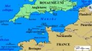
It is a wide, rectangular inlet of the English ChannelEnglish Channel
The English Channel , often referred to simply as the Channel, is an arm of the Atlantic Ocean that separates southern England from northern France, and joins the North Sea to the Atlantic. It is about long and varies in width from at its widest to in the Strait of Dover...
, approximately 100 kilometres (east-west) by 45 kilometres, bounded in the west by the Cotentin Peninsula
Cotentin Peninsula
The Cotentin Peninsula, also known as the Cherbourg Peninsula, is a peninsula in Normandy, forming part of the north-western coast of France. It juts out north-westwards into the English Channel, towards Great Britain...
, in the south by the Normandy
Normandy
Normandy is a geographical region corresponding to the former Duchy of Normandy. It is in France.The continental territory covers 30,627 km² and forms the preponderant part of Normandy and roughly 5% of the territory of France. It is divided for administrative purposes into two régions:...
coast and in the east by the estuary of the river Seine
Seine
The Seine is a -long river and an important commercial waterway within the Paris Basin in the north of France. It rises at Saint-Seine near Dijon in northeastern France in the Langres plateau, flowing through Paris and into the English Channel at Le Havre . It is navigable by ocean-going vessels...
at Le Havre
Le Havre
Le Havre is a city in the Seine-Maritime department of the Haute-Normandie region in France. It is situated in north-western France, on the right bank of the mouth of the river Seine on the English Channel. Le Havre is the most populous commune in the Haute-Normandie region, although the total...
. The coast alternates between sandy beaches and rocky promontories and, in general, it offers little shelter for shipping. At the western end of the bay are the Îles Saint-Marcouf
Îles Saint-Marcouf
Îles Saint-Marcouf are a group of two small uninhabited islands off the coast of Normandy, France. They lie in the Baie de la Seine region of the English Channel and are 6.5 kilometres east of the coast of the Cotentin peninsula at Ravenoville and 13 kilometres from the island of Tatihou...
.
Economy
Le Havre is the major port of the region; there are minor harbours at BarfleurBarfleur
Barfleur is a commune in the Manche department in the Basse-Normandie region in north-western France.-Middle Ages:In the Middle Ages Barfleur was one of the chief ports of embarkation for England....
, Port-en-Bessin
Port-en-Bessin-Huppain
Port-en-Bessin-Huppain is a commune in the Calvados department in the Basse-Normandie region in northwestern France.The commune contains the two towns of Port-en-Bessin and Huppain.-Population:-Media:...
, Courseulles-sur-Mer
Courseulles-sur-Mer
Courseulles-sur-Mer is a commune in the Calvados department in the Basse-Normandie region in northwestern France.It is a popular tourist destination not only with locals but also with international visitors who come to tour the Normandy landing beaches...
, Langrune-sur-Mer
Langrune-sur-Mer
-References:*...
, Ouistreham
Ouistreham
Ouistreham is a commune in the Calvados department' in the Basse-Normandie region in northwestern France.Ouistreham is a small port with fishing boats, leisure craft and a ferry-harbour. It serves as the port of the city of Caen. The town is about the mouth of the Canal de Caen à la...
, Trouville-sur-Mer
Trouville-sur-Mer
Trouville-sur-Mer, commonly referred to as Trouville, is a commune in the Calvados department in the Basse-Normandie region in northwestern France.Trouville-sur-Mer borders Deauville...
and Honfleur
Honfleur
Honfleur is a commune in the Calvados department in northwestern France. It is located on the southern bank of the estuary of the Seine across from le Havre and very close to the exit of the Pont de Normandie...
.
Domestic and foreign tourists visit the coast, given its World War II associations, sandy beaches and proximity to Paris. There are coastal resorts at Arromanches, Deauville
Deauville
Deauville is a commune in the Calvados département in the Basse-Normandie region in northwestern France.With its racecourse, harbour, international film festival, marinas, conference centre, villas, Grand Casino and sumptuous hotels, Deauville is regarded as the "queen of the Norman beaches" and...
, Cabourg
Cabourg
Cabourg is a commune in the Calvados department in the Basse-Normandie region of France.Cabourg belongs to the Paris Basin. The commune is located next to the sea and the back country is a plain, favourable to the cereal culture...
, Houlgate
Houlgate
Houlgate is a small tourist resort in northwestern France along the English Channel with a beach and a casino. It is a commune in the Drochon Valley, in the Calvados department in the Basse-Normandie region.-Pre-19th century:...
, Villers-sur-Mer
Villers-sur-Mer
-Places of interest:Villers-sur-Mer is known for the large topiary dinosaurs facing the sea from the garden of the office of tourism. In certain years, a baby dinosaur is added to the garden....
, Trouville-sur-Mer
Trouville-sur-Mer
Trouville-sur-Mer, commonly referred to as Trouville, is a commune in the Calvados department in the Basse-Normandie region in northwestern France.Trouville-sur-Mer borders Deauville...
and Honfleur
Honfleur
Honfleur is a commune in the Calvados department in northwestern France. It is located on the southern bank of the estuary of the Seine across from le Havre and very close to the exit of the Pont de Normandie...
.
History
The Battles of Barfleur and La Hogue were naval battles fought off Barfleur and Saint-Vaast-la-HougueSaint-Vaast-la-Hougue
Saint-Vaast-la-Hougue is a commune in the Manche department in Normandy in north-western France.-Geography:Saint-Vaast-la-Hougue is situated in the Manche département, in the Basse-Normandie région. It is in the Quettehou canton, of the Cherbourg arrondissement. The town had a population of 2,097...
in the 17th century.
The Normandy coast was the location, during World War II
World War II
World War II, or the Second World War , was a global conflict lasting from 1939 to 1945, involving most of the world's nations—including all of the great powers—eventually forming two opposing military alliances: the Allies and the Axis...
, of the main Allied landings in France
Operation Neptune
The Normandy landings, codenamed Operation Neptune, were the landing operations of the Allied invasion of Normandy, in Operation Overlord, during World War II. The landings commenced on Tuesday, 6 June 1944 , beginning at 6:30 AM British Double Summer Time...
; the unavailability of significant harbours caused the Allies to construct artificial harbours (Mulberries
Mulberry harbour
A Mulberry harbour was a British type of temporary harbour developed in World War II to offload cargo on the beaches during the Allied invasion of Normandy....
) at Arromanches and Omaha Beach
Omaha Beach
Omaha Beach is the code name for one of the five sectors of the Allied invasion of German-occupied France in the Normandy landings on 6 June 1944, during World War II...
. There are remains of these harbours at Arromanches.