
.gif)
Bad River (Wisconsin)
Encyclopedia
River
A river is a natural watercourse, usually freshwater, flowing towards an ocean, a lake, a sea, or another river. In a few cases, a river simply flows into the ground or dries up completely before reaching another body of water. Small rivers may also be called by several other names, including...
flowing to Lake Superior
Lake Superior
Lake Superior is the largest of the five traditionally-demarcated Great Lakes of North America. It is bounded to the north by the Canadian province of Ontario and the U.S. state of Minnesota, and to the south by the U.S. states of Wisconsin and Michigan. It is the largest freshwater lake in the...
in northern Wisconsin
Wisconsin
Wisconsin is a U.S. state located in the north-central United States and is part of the Midwest. It is bordered by Minnesota to the west, Iowa to the southwest, Illinois to the south, Lake Michigan to the east, Michigan to the northeast, and Lake Superior to the north. Wisconsin's capital is...
in the United States
United States
The United States of America is a federal constitutional republic comprising fifty states and a federal district...
. It flows for 76 miles (122 km) in Ashland County, draining an area of 1,061 square miles (2,748 km²) in portions of Ashland, Bayfield and Iron
Iron County, Wisconsin
Iron County is a county located in the U.S. state of Wisconsin. As of 2000, the population was 6,861. Its county seat is Hurley.-Geography:According to the U.S...
Counties.
The Bad River issues from the southwestern end of Caroline Lake, a 129 acres (52.2 ha) shallow lake on the boundary of Ashland and Iron Counties which drains an area of acidic peat
Peat
Peat is an accumulation of partially decayed vegetation matter or histosol. Peat forms in wetland bogs, moors, muskegs, pocosins, mires, and peat swamp forests. Peat is harvested as an important source of fuel in certain parts of the world...
lands to its east. The Bad River initially flows southwestwardly before turning generally to the north for most of its course, along which it passes through the city of Mellen
Mellen, Wisconsin
Mellen is a city in Ashland County in the U.S. state of Wisconsin. The population was 845 at the 2000 census.-Attractions:*Camp Eagle Ridge, a coeducational leadership summer camp, is located in Mellen.*Copper Falls State Park is also located in Mellen....
, Copper Falls State Park
Copper Falls State Park
Copper Falls State Park is a Wisconsin state park in which the Bad River and its tributary the Tylers Forks flow through a gorge and drop over several waterfalls. Old Copper Culture Indians and later European settlers mined copper in the area. The state park was created in 1929 and amenities...
, and the community of Odanah
Odanah, Wisconsin
Odanah is a census-designated place in Ashland County, Wisconsin, United States. The population was 254 at the 2000 census.Odanah is the cultural and administrative center of the Bad River Chippewa Band of the Chippewa.-Geography:...
in the Bad River Indian Reservation. In the vicinity of Mellen, the riverbed is commonly bedrock
Bedrock
In stratigraphy, bedrock is the native consolidated rock underlying the surface of a terrestrial planet, usually the Earth. Above the bedrock is usually an area of broken and weathered unconsolidated rock in the basal subsoil...
and boulder
Boulder
In geology, a boulder is a rock with grain size of usually no less than 256 mm diameter. While a boulder may be small enough to move or roll manually, others are extremely massive....
-strewn with numerous whitewater
Whitewater
Whitewater is formed in a rapid, when a river's gradient increases enough to disturb its laminar flow and create turbulence, i.e. form a bubbly, or aerated and unstable current; the frothy water appears white...
rapids; the river passes over waterfalls and through a granite
Granite
Granite is a common and widely occurring type of intrusive, felsic, igneous rock. Granite usually has a medium- to coarse-grained texture. Occasionally some individual crystals are larger than the groundmass, in which case the texture is known as porphyritic. A granitic rock with a porphyritic...
gorge
Canyon
A canyon or gorge is a deep ravine between cliffs often carved from the landscape by a river. Rivers have a natural tendency to reach a baseline elevation, which is the same elevation as the body of water it will eventually drain into. This forms a canyon. Most canyons were formed by a process of...
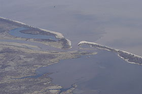
in Copper Falls State Park. In its lower course in the Bad River Reservation the river's delta
River delta
A delta is a landform that is formed at the mouth of a river where that river flows into an ocean, sea, estuary, lake, reservoir, flat arid area, or another river. Deltas are formed from the deposition of the sediment carried by the river as the flow leaves the mouth of the river...
along Lake Superior contributes to a 16000 acres (6,475 ha) complex of wetland
Wetland
A wetland is an area of land whose soil is saturated with water either permanently or seasonally. Wetlands are categorised by their characteristic vegetation, which is adapted to these unique soil conditions....
s known as slough
Swamp
A swamp is a wetland with some flooding of large areas of land by shallow bodies of water. A swamp generally has a large number of hammocks, or dry-land protrusions, covered by aquatic vegetation, or vegetation that tolerates periodical inundation. The two main types of swamp are "true" or swamp...
s.
The Bad River's largest tributary
Tributary
A tributary or affluent is a stream or river that flows into a main stem river or a lake. A tributary does not flow directly into a sea or ocean...
is the White River, which it collects near its mouth. Other principal tributaries include the Potato and Marengo Rivers in its lower course; the Tyler Forks at Copper Falls State Park; and the Iron River upstream of Mellen.
Variant names
The United States Board on Geographic NamesUnited States Board on Geographic Names
The United States Board on Geographic Names is a United States federal body whose purpose is to establish and maintain uniform usage of geographic names throughout the U.S. government.-Overview:...
issued a decision clarifying the Bad River's name and course in 1965. According to the Geographic Names Information System
Geographic Names Information System
The Geographic Names Information System is a database that contains name and locative information about more than two million physical and cultural features located throughout the United States of America and its territories. It is a type of gazetteer...
, the stream has also been known historically as:
- Mashki-Sibi
- Maskesipi
- Maskigo
- Mushkeesebe
- Swamp River