
Aybasti
Encyclopedia
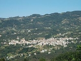
Aybastı is a town and district of Ordu Province
in the Black Sea
region of Turkey
. According to the 2000 census, population of the district is 31,071 of which 14,326 live in the town of Aybastı. The district covers an area of 423 km² (163 sq mi), and the town lies at an elevation of 664 m (2,178 ft).
coast, 54 km inland from the coastal town of Fatsa
. The climate and flora are typical of the central Black Sea region although the district is drier at high altitudes. This is good agricultural land with 192 km² (74 sq mi) of meadow and 116 km² (45 sq mi) of farmland. The road up here from the coast is slow and winding, the journey takes over an hour, and journey from here up into the mountains is even worse, some of it on dirt roads. The people of these country villages are very traditional, for example they marry between the ages of 15 and 22 by arrangement between the families.
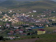
Aybastı itself is a small town providing high schools, a hospital and other basic amenities to the surrounding area. Market day is Saturday. The town is growing and today most buildings are four stories or more, the local economy is boosted by money coming from families that since the 1960s have been living and working in Istanbul
, Ankara
or abroad (especially France and Austria).
Perşembe Plateau has one of the best example of meander in Turkey even its picture is already taken place at geography textbooks.
Ordu Province
Ordu Province is a province of Turkey, located on the Black Sea coast. Its adjacent provinces are Samsun to the northwest, Tokat to the southwest, Sivas to the south, and Giresun to the east. Its traffic code is 52...
in the Black Sea
Black Sea Region
The Black Sea Region is one of Turkey's seven census-defined geographical regions . It is bordered by the Marmara Region to the west, the Central Anatolia Region to the south, the Eastern Anatolia Region to the southeast, the Republic of Georgia to the northeast, and the Black Sea to the north.-...
region of Turkey
Turkey
Turkey , known officially as the Republic of Turkey , is a Eurasian country located in Western Asia and in East Thrace in Southeastern Europe...
. According to the 2000 census, population of the district is 31,071 of which 14,326 live in the town of Aybastı. The district covers an area of 423 km² (163 sq mi), and the town lies at an elevation of 664 m (2,178 ft).
Etymology
The town was formerly known as Ibasdi (variants include Ibasda and Ibassa) and mutated to Aybastı in the 20th century.Geography
Aybastı is a rural, agricultural district in the foothills of the Canik Mountains above the Black SeaBlack Sea
The Black Sea is bounded by Europe, Anatolia and the Caucasus and is ultimately connected to the Atlantic Ocean via the Mediterranean and the Aegean seas and various straits. The Bosphorus strait connects it to the Sea of Marmara, and the strait of the Dardanelles connects that sea to the Aegean...
coast, 54 km inland from the coastal town of Fatsa
Fatsa
Fatsa is a town and a large district of Ordu Province in the central Black Sea region of Turkey.-Etymology:The name Fatsa derives from Fanizan daughter of King Pharnaces II of Pontus and has since mutated through Fanise, Phadsane, Pytane, Facha and today's Fatsa. In the Ottoman Empire records the...
. The climate and flora are typical of the central Black Sea region although the district is drier at high altitudes. This is good agricultural land with 192 km² (74 sq mi) of meadow and 116 km² (45 sq mi) of farmland. The road up here from the coast is slow and winding, the journey takes over an hour, and journey from here up into the mountains is even worse, some of it on dirt roads. The people of these country villages are very traditional, for example they marry between the ages of 15 and 22 by arrangement between the families.
Aybastı itself is a small town providing high schools, a hospital and other basic amenities to the surrounding area. Market day is Saturday. The town is growing and today most buildings are four stories or more, the local economy is boosted by money coming from families that since the 1960s have been living and working in Istanbul
Istanbul
Istanbul , historically known as Byzantium and Constantinople , is the largest city of Turkey. Istanbul metropolitan province had 13.26 million people living in it as of December, 2010, which is 18% of Turkey's population and the 3rd largest metropolitan area in Europe after London and...
, Ankara
Ankara
Ankara is the capital of Turkey and the country's second largest city after Istanbul. The city has a mean elevation of , and as of 2010 the metropolitan area in the entire Ankara Province had a population of 4.4 million....
or abroad (especially France and Austria).
Places of interest
- Perşembe Plateau is a high meadow, one of the biggest tourist attractions in the area, located 17 km from the town of Aybastı. Under snow in winter but popular with walkers and trekkers in summer, when there are folklore festivals and country fairs in the 3rd week of July.
Perşembe Plateau has one of the best example of meander in Turkey even its picture is already taken place at geography textbooks.
External links
District governor's official website Aybastı municipality-
- photographs local info website (follow "resimler" for more photos) and another one
- Road map of Aybastı and environs
- Various images of Aybastı, Ordu
- Epasa - Έπασα - Aybasti