

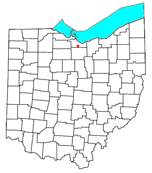
Avery, Ohio
Encyclopedia
Unincorporated area
In law, an unincorporated area is a region of land that is not a part of any municipality.To "incorporate" in this context means to form a municipal corporation, a city, town, or village with its own government. An unincorporated community is usually not subject to or taxed by a municipal government...
in western Milan Township
Milan Township, Erie County, Ohio
Milan Township is one of the nine townships of Erie County, Ohio, United States. It is part of the Sandusky, Ohio metropolitan statistical area...
, Erie County
Erie County, Ohio
As of the census of 2000, there were 79,551 people, 31,727 households, and 21,764 families residing in the county. The population density was 312 people per square mile . There were 35,909 housing units at an average density of 141 per square mile...
, Ohio
Ohio
Ohio is a Midwestern state in the United States. The 34th largest state by area in the U.S.,it is the 7th‑most populous with over 11.5 million residents, containing several major American cities and seven metropolitan areas with populations of 500,000 or more.The state's capital is Columbus...
, United States
United States
The United States of America is a federal constitutional republic comprising fifty states and a federal district...
. It is part of the Sandusky
Sandusky, Ohio
Sandusky is a city in the U.S. state of Ohio and the county seat of Erie County. It is located in northern Ohio and is situated on the shores of Lake Erie, almost exactly half-way between Toledo to the west and Cleveland to the east....
Metropolitan Statistical Area. Avery is located along US Route 250
U.S. Route 250
U.S. Route 250 is a route of the United States Numbered Highway System, and is a spur of U.S. Route 50. It currently runs for from Sandusky, Ohio to Richmond, Virginia. It passes through the states of Virginia, West Virginia, and Ohio. It goes through the cities of Richmond, Virginia,...
near that road's interchange with Interstate 80
Interstate 80
Interstate 80 is the second-longest Interstate Highway in the United States, following Interstate 90. It is a transcontinental artery running from downtown San Francisco, California to Teaneck, New Jersey in the New York City Metropolitan Area...
and Interstate 90
Interstate 90
Interstate 90 is the longest Interstate Highway in the United States at . It is the northernmost coast-to-coast interstate, and parallels US 20 for the most part. Its western terminus is in Seattle, at Edgar Martinez Drive S. near Safeco Field and CenturyLink Field, and its eastern terminus is in...
, the Ohio Turnpike
Ohio Turnpike
The Ohio Turnpike, officially the James W. Shocknessy Ohio Turnpike, is a -long, limited-access toll highway in the U.S. state of Ohio, serving as a primary corridor to Chicago and Pittsburgh...
. The area is characterized by hotels and some industry. It once had a post office
Post office
A post office is a facility forming part of a postal system for the posting, receipt, sorting, handling, transmission or delivery of mail.Post offices offer mail-related services such as post office boxes, postage and packaging supplies...
, but is now included in the Milan, Ohio
Milan, Ohio
Milan is a village in Erie and Huron counties in the U.S. state of Ohio. The population was 1,445 at the 2000 census.The Erie County portion of Milan is part of the Sandusky Metropolitan Statistical Area, while the Huron County portion is part of the Norwalk Micropolitan Statistical Area.-History...
postal zone (44846).
History
Avery was an early name given to the location of the current community and became the first county seatCounty seat
A county seat is an administrative center, or seat of government, for a county or civil parish. The term is primarily used in the United States....
of Huron County
Huron County, Ohio
As of the census of 2000, there were 59,487 people, 22,307 households, and 16,217 families residing in the county. The population density was 121 people per square mile . There were 23,594 housing units at an average density of 48 per square mile...
in 1815. Confusingly, when the plat of the proposed town was recorded by David Abbott and Kneeland Townsend at Cleveland on June 14, 1811, they named it Huron; and a copy of the plat map is to be seen at the Huron County Recorders Office {O.S. Vol. 1. Page 279]. The name had been changed to Avery by 1815. Avery/Huron was located 2 miles/3.2 kilometers east of the current location of Avery, on the east bank of the Huron River
Huron River (Ohio)
The Huron River is a waterway in the north central Ohio in the United States. The watershed drains large portions of Erie County and Huron County, the northeast corners of Seneca County and Crawford County, and northern portions of Richland County....
. An early landowner, Mr. F.W. Fowler, was elected first constable
Constable
A constable is a person holding a particular office, most commonly in law enforcement. The office of constable can vary significantly in different jurisdictions.-Etymology:...
of Huron County, and his log cabin
Log cabin
A log cabin is a house built from logs. It is a fairly simple type of log house. A distinction should be drawn between the traditional meanings of "log cabin" and "log house." Historically most "Log cabins" were a simple one- or 1½-story structures, somewhat impermanent, and less finished or less...
served as the county courthouse and jail shortly afterward. In response to increasing hostilities with the United Kingdom
United Kingdom
The United Kingdom of Great Britain and Northern IrelandIn the United Kingdom and Dependencies, other languages have been officially recognised as legitimate autochthonous languages under the European Charter for Regional or Minority Languages...
and their allies among the Native Americans
Native Americans in the United States
Native Americans in the United States are the indigenous peoples in North America within the boundaries of the present-day continental United States, parts of Alaska, and the island state of Hawaii. They are composed of numerous, distinct tribes, states, and ethnic groups, many of which survive as...
in the area, culminating with the War of 1812
War of 1812
The War of 1812 was a military conflict fought between the forces of the United States of America and those of the British Empire. The Americans declared war in 1812 for several reasons, including trade restrictions because of Britain's ongoing war with France, impressment of American merchant...
, a stockade
Stockade
A stockade is an enclosure of palisades and tall walls made of logs placed side by side vertically with the tops sharpened to provide security.-Stockade as a security fence:...
fort called "Camp Avery" or "Fort Avery" was also constructed at this location. The "old county seat" was abandoned in 1818 when the county seat was moved to Norwalk
Norwalk, Ohio
At the 2000 census, there were 16,238 people, 6,377 households and 4,234 families residing in the city. The population density was 1,950.3 per square mile . There were 6,687 housing units at an average density of 803.1 per square mile...
.
Huron County was established by the Ohio General Assembly
Ohio General Assembly
The Ohio General Assembly is the state legislature of the U.S. state of Ohio. It consists of the 99-member Ohio House of Representatives and the 33-member Ohio Senate...
on February 7, 1809 but it was administered in succession by Portage, Geauga, and Cuyahoga Counties until by act of the Legislature, passed January 31, 1815 Huron County became self- administered and, at the time, comprised present-day Erie County, Huron County, Ruggles Township
Ruggles Township, Ashland County, Ohio
Ruggles Township is one of the fifteen townships of Ashland County, Ohio, United States. The 2000 census found 857 people in the township.-Geography:Located in the northwestern corner of the county, it borders the following townships:...
in Ashland County
Ashland County, Ohio
Ashland County is a county located in the state of Ohio, United States, and was formed in 1846 from parts of Huron, Lorain, Richland and Wayne Counties. As of the 2010 census, the population was 53,139. Its county seat is Ashland...
, and Danbury Township
Danbury Township, Ottawa County, Ohio
Danbury Township is one of the twelve townships of Ottawa County, Ohio, United States. The 2000 census found 4,631 people in the township, 3,869 of whom lived in the unincorporated portions of the township.-Geography:...
in Ottawa County
Ottawa County, Ohio
Ottawa County is a county located in the state of Ohio, United States. As of the 2010 census, the population was 41,428. Its county seat is Port Clinton and is named either for the Ottawa Indians who lived there, or for an Indian word meaning "trader"....
. This region is also known as the Firelands
Firelands
The Firelands or Sufferers' Lands tract was located at the western end of the Connecticut Western Reserve in what is now the U.S. state of Ohio...
.
The area currently known as Avery was the name given to a depot built in 1882 by the New York, Chicago and St. Louis Railroad
New York, Chicago and St. Louis Railroad
The New York, Chicago and St. Louis Railroad , abbreviated NYC&St.L, was a railroad that operated in the mid-central United States. Commonly referred to as the Nickel Plate Road, the railroad served a large area, including trackage in the states of New York, Pennsylvania, Ohio, Indiana, and Illinois...
where it crossed the Norwalk-Sandusky
Sandusky, Ohio
Sandusky is a city in the U.S. state of Ohio and the county seat of Erie County. It is located in northern Ohio and is situated on the shores of Lake Erie, almost exactly half-way between Toledo to the west and Cleveland to the east....
road that became US Route 250
U.S. Route 250
U.S. Route 250 is a route of the United States Numbered Highway System, and is a spur of U.S. Route 50. It currently runs for from Sandusky, Ohio to Richmond, Virginia. It passes through the states of Virginia, West Virginia, and Ohio. It goes through the cities of Richmond, Virginia,...
. In 1893, it became a stop on the Sandusky, Milan and Norwalk interurban
Interurban
An interurban, also called a radial railway in parts of Canada, is a type of electric passenger railroad; in short a hybrid between tram and train. Interurbans enjoyed widespread popularity in the first three decades of the twentieth century in North America. Until the early 1920s, most roads were...
railroad, later becoming the Lake Shore Electric Railway.