

Australian Antarctic Territory
Encyclopedia
The Australian Antarctic Territory (AAT) is a part of Antarctica. It was claimed by the United Kingdom
and placed under the authority of the Commonwealth of Australia in 1933. It is the largest territory of Antarctica claimed by any nation. Since the Antarctic Treaty came into force in 1961, Article 1 of which states "The treaty does not recognize, dispute, nor establish territorial sovereignty claims; no new claims shall be asserted while the treaty is in force", most countries do not recognise territorial claims in Antarctica.
and between 45°E
and 160°E
, except for Adélie Land
(136°E
to 142°E
), which divides the territory into Western AAT (the larger portion) and Eastern AAT. It is bounded by Queen Maud Land
in the West and by Ross Dependency
in the East. The area is estimated at 5,896,500 km².
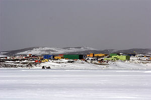
The territory is inhabited by the staff of research stations. The Australian Antarctic Division
administers the area primarily by maintaining three year-round stations (Mawson
, Davis
and Casey
), which support various research projects.
 Active and closed stations in the territory, from West to East:
first claimed Victoria Land
on 9 January 1841 and then claimed Enderby Land
in 1930. In 1933, a British imperial order transferred territory south of 60° S
and between meridians
160° E
and 45° E
to Australia.
The borders with Adélie Land
were fixed definitively in 1938. In 1947, Britain transferred Heard Island and McDonald Islands
to the territory. On 13 February 1954, Mawson Station
was established as the first Australian station on the continent proper.
, New Zealand
, France
and Norway
. Japan
does not recognise this claim, and Japan does not recognise the Australian claim to the Australian Antarctic territorial waters
in which Japanese ships conduct whaling. http://www.austlii.edu.au/cgi-bin/sinodisp/au/cases/cth/FCA/2008/3.html?query=title%28Humane%20Society%20International,%20Inc.%20%20and%20.%20Kyodo%20Senpaku%20Kaisha,%20Ltd%29
on the mineral rich continent. Several mining proposals have been taken to the ballot
, and all have been defeated.
On the 9 August 2011, influential Australian think-tank, the Lowy Institute, published a report warning Canberra against complacency when it comes to its claim. The global treaty banning resource exploitation becomes reviewable in 2041, and some states may then decide to withdraw from it considering the continent's mineral deposits. These include coal seams, manganese, iron and uranium, while Antarctica's forecast oil reserves are estimated as among the largest in the world after Saudi Arabia and Venezuela. Lowy's national security fellow Ellie Fogarty said in the paper that Australia cannot adequately patrol its claim, lacking the kind of ski-planes it needs to reach some areas. It also lacks an ice-breaking ship in the region.
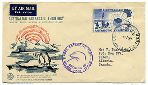 Australia issues postage stamp
s for the Australian Antarctic Territory. The first issues came in 1957, and sporadically thereafter, settling into a pattern of an annual issue by the 1990s. All have been Antarctic-themed, and all are valid for postage in Australia and its territories, including Antarctica.
United Kingdom
The United Kingdom of Great Britain and Northern IrelandIn the United Kingdom and Dependencies, other languages have been officially recognised as legitimate autochthonous languages under the European Charter for Regional or Minority Languages...
and placed under the authority of the Commonwealth of Australia in 1933. It is the largest territory of Antarctica claimed by any nation. Since the Antarctic Treaty came into force in 1961, Article 1 of which states "The treaty does not recognize, dispute, nor establish territorial sovereignty claims; no new claims shall be asserted while the treaty is in force", most countries do not recognise territorial claims in Antarctica.
Area
AAT consists of all the islands and territory south of 60°S60th parallel south
The 60th parallel south is a circle of latitude that is 60 degrees south of the Earth's equatorial plane. No land lies on the parallel—it crosses nothing but ocean...
and between 45°E
45th meridian east
The meridian 45° east of Greenwich is a line of longitude that extends from the North Pole across the Arctic Ocean, Europe, Asia, Africa, the Indian Ocean, the Southern Ocean, and Antarctica to the South Pole....
and 160°E
160th meridian east
The meridian 160° east of Greenwich is a line of longitude that extends from the North Pole across the Arctic Ocean, Asia, the Pacific Ocean, the Southern Ocean, and Antarctica to the South Pole....
, except for Adélie Land
Adélie Land
Adélie Land is the portion of the Antarctic coast between 136° E and 142° E , with a shore length of 350 km and with its hinterland extending as a sector about 2,600 km toward the South Pole. It is claimed by France as one of five districts of the French Southern and Antarctic Lands, although not...
(136°E
136th meridian east
The meridian 136° east of Greenwich is a line of longitude that extends from the North Pole across the Arctic Ocean, Asia, the Pacific Ocean, Australasia, the Indian Ocean, the Southern Ocean, and Antarctica to the South Pole....
to 142°E
142nd meridian east
The 142nd meridian east of Greenwich is a line of longitude that extends from the North Pole across the Arctic Ocean, Asia, the Pacific Ocean, Australasia, the Indian Ocean, the Southern Ocean, and Antarctica to the South Pole....
), which divides the territory into Western AAT (the larger portion) and Eastern AAT. It is bounded by Queen Maud Land
Queen Maud Land
Queen Maud Land is a c. 2.7 million-square-kilometre region of Antarctica claimed as a dependent territory by Norway. The territory lies between 20° west and 45° east, between the British Antarctic Territory to the west and the Australian Antarctic Territory to the east. The latitudinal...
in the West and by Ross Dependency
Ross Dependency
The Ross Dependency is a region of Antarctica defined by a sector originating at the South Pole, passing along longitudes 160° east to 150° west, and terminating at latitude 60° south...
in the East. The area is estimated at 5,896,500 km².
The territory is inhabited by the staff of research stations. The Australian Antarctic Division
Australian Antarctic Division
The Australian Antarctic Division is an agency of the Department of Sustainability, Environment, Water, Population and Communities . The division undertakes science programs and research projects to contribute to an understanding of Antarctica and the Southern Ocean...
administers the area primarily by maintaining three year-round stations (Mawson
Mawson Station
Mawson Station is one of three permanent Australian bases in the Australian Antarctic Territory of East Antarctica. Named after Antarctic explorer Sir Douglas Mawson, the base is managed by the Australian Antarctic Division...
, Davis
Davis Station
Davis Station is a permanent base in Antarctica managed by the Australian Antarctic Division . It is the busiest Australian scientific research station...
and Casey
Casey Station
Casey Station is a permanent base in Antarctica managed by the Australian Antarctic Division located on Vincennes Bay in the Australian Antarctic Territory.- History :...
), which support various research projects.
Subdivisions
The territory is divided into nine districts, which are from West to East:| No. | District | Area (km²) | Western Border | Eastern Border |
|---|---|---|---|---|
| 1 | Enderby Land Enderby Land Enderby Land is a projecting land mass of Antarctica, extending from Shinnan Glacier at to William Scoresby Bay at .Enderby Land was discovered in February 1831 by John Biscoe in the whaling brig Tula, and named after the Enderby Brothers of London, owners of the Tula, who encouraged their... |
045° E | 056°25' E | |
| 2 | Kemp Land Kemp Land Kemp Land is a thin sliver of Antarctica including, and lying inland from, the Kemp Coast. Part of the Australian Antarctic claim it is defined as lying between 56° 25' E and 59° 34' E, and, as with other sectors of the Antarctic, is deemed as being limited by the 60° S parallel. It is bounded in... |
056°25' E | 059°34' E | |
| 3 | Mac. Robertson Land Mac. Robertson Land Mac. Robertson Land is the portion of Antarctica lying southward of the coast between William Scoresby Bay and Cape Darnley. Mac. Robertson Land is located at . In the east, Mac. Robertson Land includes the Prince Charles Mountains. Mac... |
059°34' E | 072°35' E | |
| 4 | Princess Elizabeth Land Princess Elizabeth Land Princess Elizabeth Land is the sector of the Australian Antarctic Territory between longitude 73° east and Cape Penck 87°43' east. Princess Elizabeth Land is located between 64°56'S and 90°00'S and between 73°35' E and 87°43'E... |
072°35' E | 087°43' E | |
| 5 | Kaiser Wilhelm II Land Kaiser Wilhelm II Land Kaiser Wilhelm II Land is the part of Antarctica lying between Cape Penck, at 87°43'E, and Cape Filchner, at 91°54'E and is claimed as part of the Australian Antarctic Territory, although this claim is not universally recognized.... |
087°43' E | 091°54' E | |
| 6 | Queen Mary Land | 091°54' E | 100°30' E | |
| 7 | Wilkes Land Wilkes Land Wilkes Land is a large district of land in eastern Antarctica, formally claimed by Australia as part of the Australian Antarctic Territory, though the validity of this claim has been placed for the period of the operation of the Antarctic Treaty, to which Australia is a signatory... |
2,600,000 | 100°30' E | 136°11' E |
| 8 | George V Land George V Land George V Land is a segment of Antarctica part of the land claimed as part of the Australian Antarctic Territory, inland from the George V Coast. As with other segments of Antarctica, it is defined by two lines of longitude, 142°02' E and 153°45' E, and by the 60°S parallel.... |
142°02' E | 153°45' E | |
| 9 | Oates Land Oates Land Oates Land is a wedge-shaped segment of East Antarctica stretching along and inland from the Oates Coast. Part of the Australian claim to the Antarctic, it extends between 153°45' E and 150° E, forming a wedge between 60° S and the South Pole. It is bounded in the east by the Ross Dependency and in... |
153°45' E | 160°00' E | |
Stations
| Station | Location | District |
|---|---|---|
| Molodyozhnaya (Russian) (closed) | 67°40′S 45°51′E | Enderby Land Enderby Land Enderby Land is a projecting land mass of Antarctica, extending from Shinnan Glacier at to William Scoresby Bay at .Enderby Land was discovered in February 1831 by John Biscoe in the whaling brig Tula, and named after the Enderby Brothers of London, owners of the Tula, who encouraged their... |
| Mawson Mawson Station Mawson Station is one of three permanent Australian bases in the Australian Antarctic Territory of East Antarctica. Named after Antarctic explorer Sir Douglas Mawson, the base is managed by the Australian Antarctic Division... (Australian) |
67°36′09.7"S 62°52′25.7"E | Mac Robertson Land (Mawson Coast Mawson Coast Mawson Coast is that portion of the coast of Mac. Robertson Land lying between William Scoresby Bay, at 59° 34'E, and Murray Monolith, in 66° 54' E. The coast was sighted during the British Australian New Zealand Antarctic Research Expedition , 1929–30, under Sir Douglas Mawson. Further exploration... ) |
| Soyuz (Russian) (closed) | 70°35′S 68°47′E | Mac Robertson Land (Lars Christensen Land) |
| Druzhnaya (Russian) (closed) | 69°44′S 72°42′E | Princess Elizabeth Land Princess Elizabeth Land Princess Elizabeth Land is the sector of the Australian Antarctic Territory between longitude 73° east and Cape Penck 87°43' east. Princess Elizabeth Land is located between 64°56'S and 90°00'S and between 73°35' E and 87°43'E... (Ingrid Christensen Land) |
| Zhongshan Antarctic Zhongshan Station Zhongshan Station is the second Chinese research station in Antarctica and was opened on February 26th, 1989.It is managed by the Polar Research Institute of China... (Chinese) |
69°22′S 76°22′E | Princess Elizabeth Land Princess Elizabeth Land Princess Elizabeth Land is the sector of the Australian Antarctic Territory between longitude 73° east and Cape Penck 87°43' east. Princess Elizabeth Land is located between 64°56'S and 90°00'S and between 73°35' E and 87°43'E... (Ingrid Christensen Land) |
| Law-Racovita Station Law-Racovita Station Law-Racoviță Station is the first permanent Romanian station for research and exploration in Antarctica, named after the Romanian explorer Emil Racoviță and inaugurated on January 13, 2006 at the location of a station constructed in 1986 by Australia and donated to Romania... (Romanian) |
69°23′18.6"S 76°22′46.2"E | Princess Elizabeth Land Princess Elizabeth Land Princess Elizabeth Land is the sector of the Australian Antarctic Territory between longitude 73° east and Cape Penck 87°43' east. Princess Elizabeth Land is located between 64°56'S and 90°00'S and between 73°35' E and 87°43'E... (Ingrid Christensen Land) |
| Progress Station Progress Station Progress is a Russian research station in Antarctica. It is located at the Larsemann Hills antarctic oasis on the shore of Prydz Bay.... (Russian) |
69°23′S 76°23′E | Princess Elizabeth Land Princess Elizabeth Land Princess Elizabeth Land is the sector of the Australian Antarctic Territory between longitude 73° east and Cape Penck 87°43' east. Princess Elizabeth Land is located between 64°56'S and 90°00'S and between 73°35' E and 87°43'E... (Ingrid Christensen Land) |
| Davis Davis Station Davis Station is a permanent base in Antarctica managed by the Australian Antarctic Division . It is the busiest Australian scientific research station... (Australian) |
68°34′35.8"S 77°58′02.6"E | Princess Elizabeth Land Princess Elizabeth Land Princess Elizabeth Land is the sector of the Australian Antarctic Territory between longitude 73° east and Cape Penck 87°43' east. Princess Elizabeth Land is located between 64°56'S and 90°00'S and between 73°35' E and 87°43'E... (Ingrid Christensen Land) |
| Sovetskaya Sovetskaya (Antarctic Research Station) Sovetskaya was a Soviet research station in Antarctica at . The surface elevation was initially reported to be 3,570 m; however, it was later revised to 3,662 m. Reached on 16 February 1958 by the 3rd Soviet Antarctic Expedition for International Geophysical Year research work, it closed on 3... (Russian) (closed) |
77°58′S 89°16′E | Wilhelm II Land |
| Mirny Station Mirny Station Mirny is a Russian science station in Antarctica, located on the Antarctic coast of the Davis Sea in the Australian Antarctic Territory. Named after support vessel of the Bellingshausen's expedition.... (Russian) |
66°33′S 93°01′E | Queen Mary Land |
| Komsomolskaya (Russian) (closed) | 74°05′S 97°29′E | Queen Mary Land |
| Vostok (Russian) | 78°28′S 106°48′E | Wilkes Land Wilkes Land Wilkes Land is a large district of land in eastern Antarctica, formally claimed by Australia as part of the Australian Antarctic Territory, though the validity of this claim has been placed for the period of the operation of the Antarctic Treaty, to which Australia is a signatory... (Knox Land) |
| Wilkes Station Wilkes Station Wilkes Station was an Antarctic research station established 29 January 1957 by the United States as one of seven U.S. stations established for the International Geophysical Year program in Antarctica... (closed) |
66°15′25.6"S 110°31′32.2"E | Wilkes Land Wilkes Land Wilkes Land is a large district of land in eastern Antarctica, formally claimed by Australia as part of the Australian Antarctic Territory, though the validity of this claim has been placed for the period of the operation of the Antarctic Treaty, to which Australia is a signatory... (Budd Land) |
| Casey Casey Station Casey Station is a permanent base in Antarctica managed by the Australian Antarctic Division located on Vincennes Bay in the Australian Antarctic Territory.- History :... (Australian) |
66°16′54.5"S 110°31′39.4"E | Wilkes Land Wilkes Land Wilkes Land is a large district of land in eastern Antarctica, formally claimed by Australia as part of the Australian Antarctic Territory, though the validity of this claim has been placed for the period of the operation of the Antarctic Treaty, to which Australia is a signatory... (Budd Land) |
| Concordia Station Concordia Station Concordia Research Station, which opened in 2005, is a research facility that was built 3,233 m above sea level at a location called Dome C on the Antarctic Plateau, Antarctica... (Dome C) (European) |
75°06′S 123°23′E | Wilkes Land Wilkes Land Wilkes Land is a large district of land in eastern Antarctica, formally claimed by Australia as part of the Australian Antarctic Territory, though the validity of this claim has been placed for the period of the operation of the Antarctic Treaty, to which Australia is a signatory... (Banzare Land) |
| Leningradskaya (Russian) (closed) | 69°30′S 159°23′E | Oates Land Oates Land Oates Land is a wedge-shaped segment of East Antarctica stretching along and inland from the Oates Coast. Part of the Australian claim to the Antarctic, it extends between 153°45' E and 150° E, forming a wedge between 60° S and the South Pole. It is bounded in the east by the Ross Dependency and in... |
History
The United KingdomUnited Kingdom
The United Kingdom of Great Britain and Northern IrelandIn the United Kingdom and Dependencies, other languages have been officially recognised as legitimate autochthonous languages under the European Charter for Regional or Minority Languages...
first claimed Victoria Land
Victoria Land
Victoria Land is a region of Antarctica bounded on the east by the Ross Ice Shelf and the Ross Sea and on the west by Oates Land and Wilkes Land. It was discovered by Captain James Clark Ross in January 1841 and named after the UK's Queen Victoria...
on 9 January 1841 and then claimed Enderby Land
Enderby Land
Enderby Land is a projecting land mass of Antarctica, extending from Shinnan Glacier at to William Scoresby Bay at .Enderby Land was discovered in February 1831 by John Biscoe in the whaling brig Tula, and named after the Enderby Brothers of London, owners of the Tula, who encouraged their...
in 1930. In 1933, a British imperial order transferred territory south of 60° S
60th parallel south
The 60th parallel south is a circle of latitude that is 60 degrees south of the Earth's equatorial plane. No land lies on the parallel—it crosses nothing but ocean...
and between meridians
Meridian (geography)
A meridian is an imaginary line on the Earth's surface from the North Pole to the South Pole that connects all locations along it with a given longitude. The position of a point along the meridian is given by its latitude. Each meridian is perpendicular to all circles of latitude...
160° E
160th meridian east
The meridian 160° east of Greenwich is a line of longitude that extends from the North Pole across the Arctic Ocean, Asia, the Pacific Ocean, the Southern Ocean, and Antarctica to the South Pole....
and 45° E
45th meridian east
The meridian 45° east of Greenwich is a line of longitude that extends from the North Pole across the Arctic Ocean, Europe, Asia, Africa, the Indian Ocean, the Southern Ocean, and Antarctica to the South Pole....
to Australia.
That part of His Majesty's dominions in the Antarctic Seas which comprises all the islands and territories other than Adélie Land which are situated south of the 60th degree of South Latitude and lying between the 160th degree of East Longitude and the 45th degree of East Longitude is hereby placed under the authority of the Commonwealth of Australia.
Australian Antarctic Territory Acceptance Act 1933
That part of the territory in the Antarctic seas which comprises all the islands and territories, other than Adelie Land, situated south of the 60th degree south latitude and lying between the 160th degree east longitude and the 45th degree east longitude, is hereby declared to be accepted by the Commonwealth as a Territory under the authority of the Commonwealth, by the name of the Australian Antarctic Territory.
The borders with Adélie Land
Adélie Land
Adélie Land is the portion of the Antarctic coast between 136° E and 142° E , with a shore length of 350 km and with its hinterland extending as a sector about 2,600 km toward the South Pole. It is claimed by France as one of five districts of the French Southern and Antarctic Lands, although not...
were fixed definitively in 1938. In 1947, Britain transferred Heard Island and McDonald Islands
Heard Island and McDonald Islands
The Heard Island and McDonald Islands are an Australian external territory and volcanic group of barren Antarctic islands, about two-thirds of the way from Madagascar to Antarctica. The group's overall size is in area and it has of coastline...
to the territory. On 13 February 1954, Mawson Station
Mawson Station
Mawson Station is one of three permanent Australian bases in the Australian Antarctic Territory of East Antarctica. Named after Antarctic explorer Sir Douglas Mawson, the base is managed by the Australian Antarctic Division...
was established as the first Australian station on the continent proper.
Recognition of Australian sovereignty
Australia's claim to sovereignty over the Australian Antarctic Territory is recognised by the United KingdomUnited Kingdom
The United Kingdom of Great Britain and Northern IrelandIn the United Kingdom and Dependencies, other languages have been officially recognised as legitimate autochthonous languages under the European Charter for Regional or Minority Languages...
, New Zealand
New Zealand
New Zealand is an island country in the south-western Pacific Ocean comprising two main landmasses and numerous smaller islands. The country is situated some east of Australia across the Tasman Sea, and roughly south of the Pacific island nations of New Caledonia, Fiji, and Tonga...
, France
France
The French Republic , The French Republic , The French Republic , (commonly known as France , is a unitary semi-presidential republic in Western Europe with several overseas territories and islands located on other continents and in the Indian, Pacific, and Atlantic oceans. Metropolitan France...
and Norway
Norway
Norway , officially the Kingdom of Norway, is a Nordic unitary constitutional monarchy whose territory comprises the western portion of the Scandinavian Peninsula, Jan Mayen, and the Arctic archipelago of Svalbard and Bouvet Island. Norway has a total area of and a population of about 4.9 million...
. Japan
Japan
Japan is an island nation in East Asia. Located in the Pacific Ocean, it lies to the east of the Sea of Japan, China, North Korea, South Korea and Russia, stretching from the Sea of Okhotsk in the north to the East China Sea and Taiwan in the south...
does not recognise this claim, and Japan does not recognise the Australian claim to the Australian Antarctic territorial waters
Australian Antarctic territorial waters
Australian Antarctic territorial waters are international waters adjacent to the part of Antarctica claimed by Australia as the Australian Antarctic Territory...
in which Japanese ships conduct whaling. http://www.austlii.edu.au/cgi-bin/sinodisp/au/cases/cth/FCA/2008/3.html?query=title%28Humane%20Society%20International,%20Inc.%20%20and%20.%20Kyodo%20Senpaku%20Kaisha,%20Ltd%29
Mining in Antarctica
For the past 20 years, Australia has been in debate on whether or not to allow miningMining
Mining is the extraction of valuable minerals or other geological materials from the earth, from an ore body, vein or seam. The term also includes the removal of soil. Materials recovered by mining include base metals, precious metals, iron, uranium, coal, diamonds, limestone, oil shale, rock...
on the mineral rich continent. Several mining proposals have been taken to the ballot
Ballot
A ballot is a device used to record choices made by voters. Each voter uses one ballot, and ballots are not shared. In the simplest elections, a ballot may be a simple scrap of paper on which each voter writes in the name of a candidate, but governmental elections use pre-printed to protect the...
, and all have been defeated.
On the 9 August 2011, influential Australian think-tank, the Lowy Institute, published a report warning Canberra against complacency when it comes to its claim. The global treaty banning resource exploitation becomes reviewable in 2041, and some states may then decide to withdraw from it considering the continent's mineral deposits. These include coal seams, manganese, iron and uranium, while Antarctica's forecast oil reserves are estimated as among the largest in the world after Saudi Arabia and Venezuela. Lowy's national security fellow Ellie Fogarty said in the paper that Australia cannot adequately patrol its claim, lacking the kind of ski-planes it needs to reach some areas. It also lacks an ice-breaking ship in the region.
Postage stamps
Postage stamp
A postage stamp is a small piece of paper that is purchased and displayed on an item of mail as evidence of payment of postage. Typically, stamps are made from special paper, with a national designation and denomination on the face, and a gum adhesive on the reverse side...
s for the Australian Antarctic Territory. The first issues came in 1957, and sporadically thereafter, settling into a pattern of an annual issue by the 1990s. All have been Antarctic-themed, and all are valid for postage in Australia and its territories, including Antarctica.