

Commercial Bay
Encyclopedia
Waitemata Harbour
The quite famous Waitemata Harbour is the main access by sea to Auckland, New Zealand. For this reason it is often referred to as Auckland Harbour, despite the fact that it is only one of two harbours surrounding the city, and is crossed by the Auckland Harbour Bridge. The Waitemata forms the north...
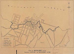
, formerly defining the original extent of the Auckland waterfront
Auckland waterfront
The Auckland waterfront is a city-side stretch of the southern Waitemata Harbour coastline in Auckland City, New Zealand...
, Auckland
Auckland
The Auckland metropolitan area , in the North Island of New Zealand, is the largest and most populous urban area in the country with residents, percent of the country's population. Auckland also has the largest Polynesian population of any city in the world...
, New Zealand
New Zealand
New Zealand is an island country in the south-western Pacific Ocean comprising two main landmasses and numerous smaller islands. The country is situated some east of Australia across the Tasman Sea, and roughly south of the Pacific island nations of New Caledonia, Fiji, and Tonga...
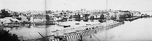
. It was framed by two substantial headlands, Smale's Point dividing it from Freemans Bay
Freemans Bay
Freemans Bay is the name of a former bay and now inner city suburb of Auckland, in the North Island of New Zealand. The historical bay was filled in to a large extent, and lost its shoreline to reclamation works...
in the west and Point Britomart
Point Britomart
Point Britomart is a former headland in the Waitemata Harbour, Auckland, New Zealand. Located between Commercial Bay and Official Bay, it was later quarried away to produce fill for land reclamation in Mechanics Bay, and no physical trace remains at street level in what is today an area of the...
dividing it from Official Bay and Mechanics Bay
Mechanics Bay
Mechanics Bay is the name of a former bay on the Waitemata Harbour in Auckland City, New Zealand. It is also the name used to describe the area of the former bay that is now mainly occupied by commercial and port facilities...
in the east.
Both headlands were quarried away roughly within the 1860-1920 period, as Auckland used their stone as fill to reclaim seashore land for the growing city and built a new waterfront with various large quays. Nowadays, the former bay and its headlands are mostly covered with high-rise buildings.
Commercial Bay was so named because from early on, it had been intended as the site for the new city's business centre.
History
John Logan Campbell
Sir John Logan Campbell was a prominent New Zealand public figure. He was the son of Doctor John Campbell and his wife Catherine. He was described by his contemporaries as "the father of Auckland".- Early life:...
erected his tent 1840 after hearing that Auckland was to become the capital of the colony. William Swainson described it thus in 1853:
- "Auckland is seen to the most advantage from the harbour. The city is built on the northern side of the isthmus which divides the Waitemata from the Manukau, and is bounded on the north by the shores of the former harbour. The site has a frontage on the water of about a mile and a half, and extends inland to the distance of about a mile. At present the greater number of the houses have been built near the water, in the bays and on the headlands with which it is indented. These bays are backed by small valleys which run inland to the distance of about half a mile, terminating in narrow gullies, and are separated from each other by spurs which run into the harbour and terminate in low headlands."
Already in 1859, a new seawall had been built running from Fort Street (previously Fore Street - along the foreshore) to the newly constructed Customs Street East, and this formed the boundary for the first 9 acres (36,421.7 m²) of infill, straightening the previously curved coastline. By this time Smale's Point was already being quarried for fill and to allow easier passage to Freemans Bay. In the 1870s and 1880s, Point Britomart followed, to provide fill for Mechanics Bay.
By 1955, around 1.6 square kilometres (390 acres) of land had been filled in, and Commercial Bay had long since ceased to exist as a recognizable landscape feature.