
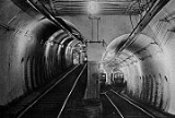
Tremont Street Subway
Encyclopedia
Boston
Boston is the capital of and largest city in Massachusetts, and is one of the oldest cities in the United States. The largest city in New England, Boston is regarded as the unofficial "Capital of New England" for its economic and cultural impact on the entire New England region. The city proper had...
's subway
Rapid transit
A rapid transit, underground, subway, elevated railway, metro or metropolitan railway system is an electric passenger railway in an urban area with a high capacity and frequency, and grade separation from other traffic. Rapid transit systems are typically located either in underground tunnels or on...
system, and is the oldest subway tunnel in North America, opening on September 1, 1897. It was originally built as a tunnel to get streetcar lines off the streets, rather than a rapid transit
Rapid transit
A rapid transit, underground, subway, elevated railway, metro or metropolitan railway system is an electric passenger railway in an urban area with a high capacity and frequency, and grade separation from other traffic. Rapid transit systems are typically located either in underground tunnels or on...
line. It now forms the central part of the Green Line
Green Line (MBTA)
The Green Line is a streetcar system run by the Massachusetts Bay Transportation Authority in the Boston, Massachusetts area of the United States. It is the oldest line of Boston's subway, which is known locally as the 'T'. The Green Line runs underground downtown and on the surface in outlying...
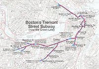
, connecting the Boylston Street
Boylston (MBTA station)
Boylston is a station on the Green Line light rail service of the MBTA rapid transport network, and is located on the southeast corner of Boston Common at the intersection of Boylston and Tremont Streets.-Location:...
station to Park Street
Park Street (MBTA station)
Park Street is a rapid transit and light rail station of the MBTA subway system in Downtown Boston. One of the four subway hub stations, Park Street is a transfer point between the Green and Red Lines. Park Street is the fourth-busiest station in the MBTA network, with an average of 19,836 entries...
and Government Center
Government Center (MBTA station)
Government Center is an MBTA subway station and a transfer point between the Green Line and the Blue Line. It is located at the intersection of Tremont, Court and Cambridge Streets in the Government Center area of Boston.-History:...
.
The tunnel originally served stations at Boylston Street, Park Street, Scollay Square
Scollay Square
Scollay Square was a vibrant city square in downtown Boston, Massachusetts. It was named for William Scollay, a prominent local developer and militia officer who bought a landmark four-story merchant building at the intersection of Cambridge and Court Streets in 1795...
, and Adams Square. The latter two stations were substantially altered when Government Center
Government Center, Boston, Massachusetts
Government Center is an area in downtown Boston, bounded by Cambridge, Court, Congress, and Sudbury Streets. Formerly the site of Scollay Square, it is now the location of Boston City Hall, two Suffolk County courthouses, two state office buildings, and two federal office buildings, a major MBTA...
and City Hall
Boston City Hall
Boston City Hall is the seat of the municipal government of Boston, Massachusetts. Architecturally, it is an example of the brutalist style. It was designed by Kallmann McKinnell & Knowles...
replaced Scollay Square and Adams Square in 1963. Adams Square was closed altogether, and Scollay Square station was completely renovated and altered, and the northbound tunnel to Haymarket
Haymarket (MBTA station)
Haymarket is a MBTA station on the Green and Orange lines, located at the corner of Congress and New Sudbury Street. Transfer between the Green and Orange Lines is possible here, although the adjacent North Station may be more convenient for some cross-platform transfers.Originally, the Orange...
was rerouted, though the southbound tunnel is still original.
Disused southern tunnel
Originally, the subway in 1897 consisted of a main line under Tremont Street that terminated at Park Street, and two forks to the south. One fork has become the extant part of the line. It veered westward along Boylston Street, toward Back Bay. The other fork continued under Tremont Street to an opening called the Pleasant Street InclinePleasant Street Incline
The Pleasant Street Incline or Pleasant Street Portal was the southern access point for the Tremont Street Subway in Boston, Massachusetts, which later became part of the Green Line .-History:...
(depicted in the photo at the right). This latter section ran streetcars that went southwest to Egleston via the South End, along Tremont Street (route 43
Boston-area streetcar lines
As with many large cities, a large number of Boston-area streetcar lines once existed. However, only a few remain, namely the four branches of the Green Line and the Ashmont-Mattapan High Speed Line, with only one running regular service on an undivided street.The Massachusetts Bay Transportation...
), and southeast to City Point
City Point
-Places:United Kingdom*CityPoint, an office tower in London, EnglandUnited States*City Point , a neighborhood in New Haven, Connecticut*City Point, Boston, a section of South Boston, Massachusetts...
in South Boston via Broadway (route 9
Boston-area streetcar lines
As with many large cities, a large number of Boston-area streetcar lines once existed. However, only a few remain, namely the four branches of the Green Line and the Ashmont-Mattapan High Speed Line, with only one running regular service on an undivided street.The Massachusetts Bay Transportation...
). While streetcar service through the southern tunnel ended in 1961, this tunnel still exists.
Entrances
The original entrances were in the Public Garden, at North Station/Canal Street, and at Pleasant Street. The other portals (at Copley SquareCopley Square
Copley Square is a public square located in the Back Bay neighborhood of Boston, Massachusetts, named for the donor of the land on which it was developed. The square is named for John Singleton Copley, a famous portrait painter of the late 18th century and native of Boston. A bronze statue of...
and directly east of Kenmore Square
Kenmore Square
Kenmore Square is a square in Boston, Massachusetts, United States, consisting of the intersection of several main avenues as well as several other cross streets, and Kenmore Station, an MBTA subway stop. Kenmore Square is close to or abuts Boston University, Fenway Park, and Lansdowne Street, a...
) have been closed as the line has been further extended.
Power
From its inception, the subway used trolleysTram
A tram is a passenger rail vehicle which runs on tracks along public urban streets and also sometimes on separate rights of way. It may also run between cities and/or towns , and/or partially grade separated even in the cities...
powered by electricity
Electricity
Electricity is a general term encompassing a variety of phenomena resulting from the presence and flow of electric charge. These include many easily recognizable phenomena, such as lightning, static electricity, and the flow of electrical current in an electrical wire...
from overhead lines
Overhead lines
Overhead lines or overhead wires are used to transmit electrical energy to trams, trolleybuses or trains at a distance from the energy supply point...
, made possible by the invention of the trolley pole
Trolley pole
A trolley pole is a tapered cylindrical pole of wood or metal, used to transfer electricity from a "live" overhead wire to the control and propulsion equipment of a tram or trolley bus. The use of overhead wire in a system of current collection is reputed to be the 1880 invention of Frank J....
in 1880 by Frank J. Sprague
Frank J. Sprague
Frank Julian Sprague was an American naval officer and inventor who contributed to the development of the electric motor, electric railways, and electric elevators...
. However, the modern line has been pantograph
Pantograph (rail)
A pantograph for rail lines is a hinged electric-rod device that collects electric current from overhead lines for electric trains or trams. The pantograph typically connects to a one-wire line, with the track acting as the ground wire...
-only since the trolley wires were modified in the 1990s.
Ownership, Landmark status
The original owner was the private West End Street Railway, later the Boston Elevated RailwayBoston Elevated Railway
The Boston Elevated Railway was a precursor first to the Metropolitan Transit Authority in Massachusetts, now the Massachusetts Bay Transportation Authority, operating rapid transit, streetcars and buses in the Boston, Massachusetts area. It was formerly known as the West End Street Railway.The...
. Public ownership began in 1947 with the Metropolitan Transit Authority, later reconstituted as the modern Massachusetts Bay Transportation Authority
Massachusetts Bay Transportation Authority
The Massachusetts Bay Transportation Authority, often referred to as the MBTA or simply The T, is the public operator of most bus, subway, commuter rail and ferry systems in the greater Boston, Massachusetts, area. Officially a "body politic and corporate, and a political subdivision" of the...
.
The Tremont Street Subway is now a National Historic Landmark
National Historic Landmark
A National Historic Landmark is a building, site, structure, object, or district, that is officially recognized by the United States government for its historical significance...
.
Further reading
- Bierman, Noah, "Transit archeology: Tour of abandoned subway network offers a glimpse of how the T was built", Boston Globe, Saturday, December 26, 2009.
- Moore, Scott, "100 Years of the Tremont Street Subway" (archived 2007)
External links
- Celebrate Boston's description and image gallery of the Tremont Street Subway
- Photos and discussion of the Tremont Street subway tunnel
- Photos of the Tremont Street subway