
Ashover
Encyclopedia
Ashover is a village in the English
county of Derbyshire
. It is in the North East Derbyshire
district of the county. It sits in a picturesque valley
, not far from the town of Matlock and the Peak District
national park
. The centre of the village is a conservation area
. The River Amber
flows through the village. Although Ashover is a small settlement, the actual ward boundaries of the village extend for many miles, including the nearby settlements of Alton
, Ashover Hay, Kelstedge, Littlemoor
, Milltown
, Spitewinter, Stone Edge and Uppertown.
times as Essovre ('beyond the ash tree
s'), Ashover was probably in existence during the first taxation survey of England by King Alfred in 893. However, the first written reference to the village occurs in the Domesday Book
of 1086, in which Ashover is owned by Ralph fitzHubert and is credited with a church, a priest, several ploughs, a mill. It had previously had a taxable value of four pounds, but it was revalued at thirty shillings.
 Ashover was the scene of a confrontation between the Royalists
and the Roundheads during the English Civil War
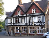
in the 17th century. The Roundheads, short of ammunition, demolished the windows of the church and used the lead to make bullets. They also reduced nearby Eastwood Hall to ruins; all that can be seen today are the ivy-clad remains. Royalists slaughtered livestock and drank all the wine and ale in the cellars of Eddlestow Hall while the owner Sir John Pershall was away. Job Wall, the landlord of the Crispin Inn public house
, refused entry to the army, telling them they had had too much to drink. But they threw him out and drank the ale, pouring what was left down the street. Outside, affixed to the front wall of the pub is a signboard with a history of the inn.
Ashover's industrial history is linked with lead mining
and quarrying, both of which date back to Roman
times. Butt's Quarry is a large disused example, previously excavated by the Clay Cross
Company for its works three miles (5 km) away. During the Second World War, prisoners of war held at Clay Cross were taken daily to the quarry to make concrete blocks. It is now home to a wide range of different species, including jackdaws
which nest on the quarry face. Part of the village was home to the stocking frame
knitting
industry, which once rivalled lead mining in importance. The area is called Rattle
, which is believed to be a reference to the noise made by the machinery.
Electricity came to the valley in the 1920s, but the village was not connected to the National Grid until a decade later. Some outlying settlements were not connected until after the Second World War. It was not until 1967 that gas street lights were replaced by electric lighting.
Until 1963, there was a hydro
in the village, sourcing its own private water supply from a tank on a hillside. Ashover had two such institutions, which were popular in the 19th century due to the belief in 'healing water'. Subsequently purchased by the electricity board, the building is today divided into private apartments, with further expensive new houses built in the grounds.
boulder and viewpoint locally known as 'The Fabrick' or 'Ashover Rock'. The Fabrick sits on an area of heathland 299 metres above sea level
. It is the highest viewpoint for a considerable distance, and the majority of the landscape east of this point to the coast is lower. Consequently, on a clear day, excellent views can be seen of nearby Chesterfield
with its famous Crooked Spire, Bolsover Castle
, Hardwick Hall
, some suburbs of the South Yorkshire
city of Sheffield
, the surrounding counties of Nottinghamshire
, Leicestershire
, Staffordshire
and, if the atmospheric conditions are right, it is possible to observe Lincoln Cathedral
, around 40 miles (64.4 km) distant, with a telescope
.
Other distant landmarks that can be seen are several power station
s by the River Trent
on the Nottinghamshire-Lincolnshire
border. These are West Burton
, near Gainsborough
, Cottam
, and High Marnham
, the latter now mothballed. Further to the north east, the cooling towers and chimneys of Drax Power Station in North Yorkshire
can be observed with binoculars, but due to the curvature of the earth
the buildings themselves cannot be viewed. Further to the south, Ratcliffe-on-Soar Power Station
can be seen, around 23 miles (37 km) away on the Nottinghamshire-Leicestershire border.
Next to The Fabrick is a disused Royal Observer Corps
monitoring station, which was abandoned in 1991. However, it is opened up occasionally by enthusiasts. For many years, The Fabrick was privately owned by the "Bassett" sisters who were descendants of the family made famous for creating "Bassetts Liquorice Allsorts", but in 2006 was donated to Derbyshire County Council. In the Victorian
period, there was a stone folly
on the top of the Fabrick, no trace of which remains today.
On important days in the pagan calendar, morris dancers gather.
The Youth Club, based at the village hall, organise night walks on Thursday evenings.
and Matlock, the village was used for a time as a location for the ITV
drama series Peak Practice
.
Ashover won the Calor Village of the Year
competition in 2005.
England
England is a country that is part of the United Kingdom. It shares land borders with Scotland to the north and Wales to the west; the Irish Sea is to the north west, the Celtic Sea to the south west, with the North Sea to the east and the English Channel to the south separating it from continental...
county of Derbyshire
Derbyshire
Derbyshire is a county in the East Midlands of England. A substantial portion of the Peak District National Park lies within Derbyshire. The northern part of Derbyshire overlaps with the Pennines, a famous chain of hills and mountains. The county contains within its boundary of approx...
. It is in the North East Derbyshire
North East Derbyshire
North East Derbyshire is a local government district in Derbyshire, England. It borders the districts of Chesterfield, Bolsover, Amber Valley and Derbyshire Dales in Derbyshire, and Sheffield and Rotherham in South Yorkshire....
district of the county. It sits in a picturesque valley
Valley
In geology, a valley or dale is a depression with predominant extent in one direction. A very deep river valley may be called a canyon or gorge.The terms U-shaped and V-shaped are descriptive terms of geography to characterize the form of valleys...
, not far from the town of Matlock and the Peak District
Peak District
The Peak District is an upland area in central and northern England, lying mainly in northern Derbyshire, but also covering parts of Cheshire, Greater Manchester, Staffordshire, and South and West Yorkshire....
national park
National park
A national park is a reserve of natural, semi-natural, or developed land that a sovereign state declares or owns. Although individual nations designate their own national parks differently A national park is a reserve of natural, semi-natural, or developed land that a sovereign state declares or...
. The centre of the village is a conservation area
Conservation area
A conservation areas is a tract of land that has been awarded protected status in order to ensure that natural features, cultural heritage or biota are safeguarded...
. The River Amber
River Amber
The River Amber is a river in Derbyshire, England which rises close to the village of Ashover, near Clay Cross, and flows southwards through Ogston Reservoir to Pentrich then westwards to join the River Derwent at Ambergate...
flows through the village. Although Ashover is a small settlement, the actual ward boundaries of the village extend for many miles, including the nearby settlements of Alton
Alton, Derbyshire
Alton is a very small village in Derbyshire, England. It is in the civil parish of Ashover, and is around 2 miles away from Clay Cross although it is not part of the town. The village does not have a church, a school or a pub, the nearest can be found in Ashover...
, Ashover Hay, Kelstedge, Littlemoor
Littlemoor, Derbyshire
Littlemoor is a small village near the town of Chesterfield. Its population is around 100. It is the closest village to Ashover Rock , Ashover....
, Milltown
Milltown, Derbyshire
Milltown is a village in Derbyshire, England. It is located 1 mile south east of Ashover and is part of Ashover civil parish. To the north of the village is Milltown Quarry, now closed. It is a small quarry, which was open for limestone extraction. The Ashover Light Railway ran through Milltown....
, Spitewinter, Stone Edge and Uppertown.
A brief history
Known in SaxonAnglo-Saxons
Anglo-Saxon is a term used by historians to designate the Germanic tribes who invaded and settled the south and east of Great Britain beginning in the early 5th century AD, and the period from their creation of the English nation to the Norman conquest. The Anglo-Saxon Era denotes the period of...
times as Essovre ('beyond the ash tree
Ash tree
Fraxinus is a genus flowering plants in the olive and lilac family, Oleaceae. It contains 45-65 species of usually medium to large trees, mostly deciduous though a few subtropical species are evergreen. The tree's common English name, ash, goes back to the Old English æsc, while the generic name...
s'), Ashover was probably in existence during the first taxation survey of England by King Alfred in 893. However, the first written reference to the village occurs in the Domesday Book
Domesday Book
Domesday Book , now held at The National Archives, Kew, Richmond upon Thames in South West London, is the record of the great survey of much of England and parts of Wales completed in 1086...
of 1086, in which Ashover is owned by Ralph fitzHubert and is credited with a church, a priest, several ploughs, a mill. It had previously had a taxable value of four pounds, but it was revalued at thirty shillings.
Cavalier
Cavalier was the name used by Parliamentarians for a Royalist supporter of King Charles I and son Charles II during the English Civil War, the Interregnum, and the Restoration...
and the Roundheads during the English Civil War
English Civil War
The English Civil War was a series of armed conflicts and political machinations between Parliamentarians and Royalists...
in the 17th century. The Roundheads, short of ammunition, demolished the windows of the church and used the lead to make bullets. They also reduced nearby Eastwood Hall to ruins; all that can be seen today are the ivy-clad remains. Royalists slaughtered livestock and drank all the wine and ale in the cellars of Eddlestow Hall while the owner Sir John Pershall was away. Job Wall, the landlord of the Crispin Inn public house
Public house
A public house, informally known as a pub, is a drinking establishment fundamental to the culture of Britain, Ireland, Australia and New Zealand. There are approximately 53,500 public houses in the United Kingdom. This number has been declining every year, so that nearly half of the smaller...
, refused entry to the army, telling them they had had too much to drink. But they threw him out and drank the ale, pouring what was left down the street. Outside, affixed to the front wall of the pub is a signboard with a history of the inn.
Ashover's industrial history is linked with lead mining
Derbyshire lead mining history
This article details some of the history of lead mining in Derbyshire, England.- Background :On one of the walls in Wirksworth church is a crude stone carving, found nearby at Bonsall and placed in the church in the 1870s. Probably executed in Anglo-Saxon times, it shows a man carrying a kibble or...
and quarrying, both of which date back to Roman
Roman Empire
The Roman Empire was the post-Republican period of the ancient Roman civilization, characterised by an autocratic form of government and large territorial holdings in Europe and around the Mediterranean....
times. Butt's Quarry is a large disused example, previously excavated by the Clay Cross
Clay Cross
Clay Cross is a former mining town and civil parish in the North East Derbyshire district of Derbyshire, England, about six miles south of Chesterfield. It is directly on the A61, the former Roman road Ryknield Street...
Company for its works three miles (5 km) away. During the Second World War, prisoners of war held at Clay Cross were taken daily to the quarry to make concrete blocks. It is now home to a wide range of different species, including jackdaws
Jackdaws
Jackdaws is a World War II spy thriller written by British novelist Ken Follett. It was published in hardcover format in 2001 by the Macmillan. It was reissued as a paperback book by Signet Books in 2002.- Plot teaser :...
which nest on the quarry face. Part of the village was home to the stocking frame
Stocking frame
A stocking frame was a mechanical knitting machine used in the textiles industry. It was invented by William Lee of Calverton near Nottingham in 1589...
knitting
Knitting
Knitting is a method by which thread or yarn may be turned into cloth or other fine crafts. Knitted fabric consists of consecutive rows of loops, called stitches. As each row progresses, a new loop is pulled through an existing loop. The active stitches are held on a needle until another loop can...
industry, which once rivalled lead mining in importance. The area is called Rattle
Rattle, Derbyshire
Rattle is a hamlet in the English county of Derbyshire. It is part of the village of Ashover. This portion of the village was the centre of stocking frame working in Ashover and probably derives its name from the noise made by the machines....
, which is believed to be a reference to the noise made by the machinery.
Electricity came to the valley in the 1920s, but the village was not connected to the National Grid until a decade later. Some outlying settlements were not connected until after the Second World War. It was not until 1967 that gas street lights were replaced by electric lighting.
Until 1963, there was a hydro
Hydrotherapy
Hydrotherapy, formerly called hydropathy, involves the use of water for pain-relief and treating illness. The term hydrotherapy itself is synonymous with the term water cure as it was originally marketed by practitioners and promoters in the 19th century...
in the village, sourcing its own private water supply from a tank on a hillside. Ashover had two such institutions, which were popular in the 19th century due to the belief in 'healing water'. Subsequently purchased by the electricity board, the building is today divided into private apartments, with further expensive new houses built in the grounds.
The Fabrick
To the east of the village is a gritstoneGritstone
Gritstone or Grit is a hard, coarse-grained, siliceous sandstone. This term is especially applied to such sandstones that are quarried for building material. British gritstone was used for millstones to mill flour, to grind wood into pulp for paper and for grindstones to sharpen blades. "Grit" is...
boulder and viewpoint locally known as 'The Fabrick' or 'Ashover Rock'. The Fabrick sits on an area of heathland 299 metres above sea level
Sea level
Mean sea level is a measure of the average height of the ocean's surface ; used as a standard in reckoning land elevation...
. It is the highest viewpoint for a considerable distance, and the majority of the landscape east of this point to the coast is lower. Consequently, on a clear day, excellent views can be seen of nearby Chesterfield
Chesterfield
Chesterfield is a market town and a borough of Derbyshire, England. It lies north of Derby, on a confluence of the rivers Rother and Hipper. Its population is 70,260 , making it Derbyshire's largest town...
with its famous Crooked Spire, Bolsover Castle
Bolsover Castle
Bolsover Castle is a castle in Bolsover, Derbyshire, England .-History:It was built by the Peverel family in the 12th century and became Crown property in 1155 when the third William Peverel fled into exile...
, Hardwick Hall
Hardwick Hall
Hardwick Hall , in Derbyshire, is one of the most significant Elizabethan country houses in England. In common with its architect Robert Smythson's other works at both Longleat House and Wollaton Hall, Hardwick Hall is one of the earliest examples of the English interpretation of the Renaissance...
, some suburbs of the South Yorkshire
South Yorkshire
South Yorkshire is a metropolitan county in the Yorkshire and the Humber region of England. It has a population of 1.29 million. It consists of four metropolitan boroughs: Barnsley, Doncaster, Rotherham, and City of Sheffield...
city of Sheffield
Sheffield
Sheffield is a city and metropolitan borough of South Yorkshire, England. Its name derives from the River Sheaf, which runs through the city. Historically a part of the West Riding of Yorkshire, and with some of its southern suburbs annexed from Derbyshire, the city has grown from its largely...
, the surrounding counties of Nottinghamshire
Nottinghamshire
Nottinghamshire is a county in the East Midlands of England, bordering South Yorkshire to the north-west, Lincolnshire to the east, Leicestershire to the south, and Derbyshire to the west...
, Leicestershire
Leicestershire
Leicestershire is a landlocked county in the English Midlands. It takes its name from the heavily populated City of Leicester, traditionally its administrative centre, although the City of Leicester unitary authority is today administered separately from the rest of Leicestershire...
, Staffordshire
Staffordshire
Staffordshire is a landlocked county in the West Midlands region of England. For Eurostat purposes, the county is a NUTS 3 region and is one of four counties or unitary districts that comprise the "Shropshire and Staffordshire" NUTS 2 region. Part of the National Forest lies within its borders...
and, if the atmospheric conditions are right, it is possible to observe Lincoln Cathedral
Lincoln Cathedral
Lincoln Cathedral is a historic Anglican cathedral in Lincoln in England and seat of the Bishop of Lincoln in the Church of England. It was reputedly the tallest building in the world for 249 years . The central spire collapsed in 1549 and was not rebuilt...
, around 40 miles (64.4 km) distant, with a telescope
Telescope
A telescope is an instrument that aids in the observation of remote objects by collecting electromagnetic radiation . The first known practical telescopes were invented in the Netherlands at the beginning of the 1600s , using glass lenses...
.
Other distant landmarks that can be seen are several power station
Power station
A power station is an industrial facility for the generation of electric energy....
s by the River Trent
River Trent
The River Trent is one of the major rivers of England. Its source is in Staffordshire on the southern edge of Biddulph Moor. It flows through the Midlands until it joins the River Ouse at Trent Falls to form the Humber Estuary, which empties into the North Sea below Hull and Immingham.The Trent...
on the Nottinghamshire-Lincolnshire
Lincolnshire
Lincolnshire is a county in the east of England. It borders Norfolk to the south east, Cambridgeshire to the south, Rutland to the south west, Leicestershire and Nottinghamshire to the west, South Yorkshire to the north west, and the East Riding of Yorkshire to the north. It also borders...
border. These are West Burton
West Burton Power Station
The West Burton power stations are a pair of power stations on the River Trent near Gainsborough, in Nottinghamshire, England, located between Bole to the north and Sturton le Steeple to the south. One is a coal-fired power station, which was commissioned in 1968, and the second is a combined cycle...
, near Gainsborough
Gainsborough, Lincolnshire
Gainsborough is a town 15 miles north-west of Lincoln on the River Trent within the West Lindsey district of Lincolnshire, England. At one time it served as an important port with trade downstream to Hull, and was the most inland in England, being more than 55 miles from the North...
, Cottam
Cottam Power Station
The Cottam power stations are a pair of power stations, located on the River Trent at Cottam near Retford in Nottinghamshire. The largest of the two is a coal-fired power station, which was commissioned in 1969 by the Central Electricity Generating Board, and has a generating capacity of 1,970...
, and High Marnham
High Marnham Power Station
High Marnham Power Station is a former coal-fired power station, currently undergoing demolition. It is located in Nottinghamshire, to the west of the River Trent, just south of the village of Dunham. It was the most southerly of three power stations which lined the River Trent, the others being...
, the latter now mothballed. Further to the north east, the cooling towers and chimneys of Drax Power Station in North Yorkshire
North Yorkshire
North Yorkshire is a non-metropolitan or shire county located in the Yorkshire and the Humber region of England, and a ceremonial county primarily in that region but partly in North East England. Created in 1974 by the Local Government Act 1972 it covers an area of , making it the largest...
can be observed with binoculars, but due to the curvature of the earth
Figure of the Earth
The expression figure of the Earth has various meanings in geodesy according to the way it is used and the precision with which the Earth's size and shape is to be defined. The actual topographic surface is most apparent with its variety of land forms and water areas. This is, in fact, the surface...
the buildings themselves cannot be viewed. Further to the south, Ratcliffe-on-Soar Power Station
Ratcliffe-on-Soar Power Station
Ratcliffe-on-Soar power station is a coal-fired power station operated by E.ON UK at Ratcliffe-on-Soar in Nottinghamshire, England. Commissioned in 1968 by the then Central Electricity Generating Board, the station has a capacity of 2,000 MW...
can be seen, around 23 miles (37 km) away on the Nottinghamshire-Leicestershire border.
Next to The Fabrick is a disused Royal Observer Corps
Royal Observer Corps
The Royal Observer Corps was a civil defence organisation operating in the United Kingdom between 29 October 1925 and 31 December 1995, when the Corps' civilian volunteers were stood down....
monitoring station, which was abandoned in 1991. However, it is opened up occasionally by enthusiasts. For many years, The Fabrick was privately owned by the "Bassett" sisters who were descendants of the family made famous for creating "Bassetts Liquorice Allsorts", but in 2006 was donated to Derbyshire County Council. In the Victorian
Victorian era
The Victorian era of British history was the period of Queen Victoria's reign from 20 June 1837 until her death on 22 January 1901. It was a long period of peace, prosperity, refined sensibilities and national self-confidence...
period, there was a stone folly
Folly
In architecture, a folly is a building constructed primarily for decoration, but either suggesting by its appearance some other purpose, or merely so extravagant that it transcends the normal range of garden ornaments or other class of building to which it belongs...
on the top of the Fabrick, no trace of which remains today.
On important days in the pagan calendar, morris dancers gather.
The Youth Club, based at the village hall, organise night walks on Thursday evenings.
Fame
The village is famous for the Ashover Light Railway, which was owned and operated by the Clay Cross Company from 1925 to 1950. Along with CrichCrich
Crich is a village in Derbyshire in England. It has the National Tramway Museum inside the Crich Tramway Village, and at the summit of Crich Hill above, a Memorial Tower for those of the Sherwood Foresters regiment who died in battle, particularly in World War I.Built in 1923 on the site of an...
and Matlock, the village was used for a time as a location for the ITV
ITV
ITV is the major commercial public service TV network in the United Kingdom. Launched in 1955 under the auspices of the Independent Television Authority to provide competition to the BBC, it is also the oldest commercial network in the UK...
drama series Peak Practice
Peak Practice
Peak Practice is a British drama series about a GP surgery in Cardale — a small fictional town in the Derbyshire Peak District — and the doctors who worked there. It ran on ITV from 10 May 1993 to 30 January 2002 and was one of their most successful series at the time...
.
Ashover won the Calor Village of the Year
Calor Village of the Year
The Calor Village of the Year comprised 4 annual competitions organised by gas provider Calor to identify the villages that best met the following criteria: "a well-balanced, pro-active, caring community which has made the best of local opportunities to maintain and enhance the quality of life for...
competition in 2005.