
Ashby-de-la-Zouch Canal
Encyclopedia
The Ashby-de-la-Zouch Canal is a 31 miles (49.9 km) long canal
in England which connected the mining district around Moira
, just outside the town of Ashby-de-la-Zouch
, with the Coventry Canal at Bedworth
in Warwickshire
. It was opened in 1804, and a number of tramways were constructed at its northern end, to service collieries. The canal was taken over by the Midland Railway
in 1846, but remained profitable until the 1890s, after which it steadily declined. Around 9 miles (14.5 km) passed through the Leicestershire coal field, and was heavily affected by subsidence, with the result that this section from Moira, southwards to Snarestone
, was progressively closed in 1944, 1957 and 1966, leaving 22 miles (35.4 km) of navigable canal.
The abandoned section is the subject of a restoration project and is the first canal where a new section has been authorised under the Transport and Works Act 1992
. The Transport and Works Order was obtained by Leicestershire County Council, as some of the original route has been infilled and built over, and restoration therefore involves construction on a new route through the centre of Measham
. It is hoped that all but the final 1 miles (1.6 km) section of the canal can be re-opened. An isolated section near Moira Furnace and the National Forest
visitor centre was opened between 1999 and 2005, and is the location for an annual trailboat festival.
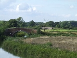
just outside Bedworth and travels north-east for about 7 miles (11 km) through the town of Hinckley
. It then continues to run north through largely rural and remote countryside for another 15 miles (24 km) until reaching its terminus at Snarestone. Near Sutton Cheney
Wharf, it passes the foot of Ambion Hill
, the site of the Battle of Bosworth Field
. At Shackerstone
, it passes the station that is the HQ of the Battlefield Line Railway
.
reserves at Ashby Wolds and lime
from the quarries north of Ashby-de-la-Zouch. The first proposal was for a canal running from Burton-on-Trent on the upper River Trent
to Marston
on the Coventry Canal
. A second suggestion was for a canal from Ashby Wolds to the Coventry Canal at Griff. Both proposals were made in December 1781. The first was opposed by the Coventry company, though the second was not. Robert Whitworth had estimated the cost of the project at £46,396, but the scheme was dropped a year later. William Jessop
proposed a canal and tramway between Breedon and the Trent, with a connecting link to the Trent and Mersey Canal
in 1787, which also came to nothing. A proposal in 1790 was well received at the time, but opposition afterwards prevented a bill being submitted to Parliament. Another proposal for a canal northwards to the Trent at Burton was actively discussed between 1791 and 1793. There was wide support for a canal to Griff in 1792, but the muted support of Penn Assheton Curzon, a local landowner and Member of Parliament, led to it being dropped.
In October 1792, Robert Whitworth revised his plan from 1781. The proposal featured a level canal from Griff, near Nuneaton
, to Ashby Wolds, which would cost £63,402. From there it would climb 139 feet (42.4 m) to a summit which would be supplied with water by a steam pumping engine. After a further 5 miles (8 km), the summit level would descend through 84 feet (25.6 m) to level branches, which would serve collieries at Ticknall
, Coleorton
, Cloud Hill, near Breedon-on-the-Hill, and Staunton Harold. The cost of this section would be £82,143. The plans were checked by Jessop, and formed the basis for a bill
to authorise a company with powers to raise £150,000 of capital. Hard negotitation with Curzon and the Coventry Canal was required, during which the junction with the Coventry Canal was moved from Griff to Marston, but the bill finally became an Act of Parliament
in May 1794. Whitworth and his son, also called Robert, were appointed as engineers in July, and construction began. (Robert Whitworth was later remembered with the naming in 2002 of Whitworth Avenue on the new George Wimpey development in Hinckley, which overlooks the Ashby Canal).
The company had been considering the option of building tramways since 1793, and finally asked Newbold to investigate the possible lines for railways which would serve the canal at Ashby Wolds in June 1798. They then asked Benjamin Outram
to advise, and he reported in September. He suggested running the lines to Willesley
Basin rather than Ashby Wolds, as this route would cost over £8,000 less. The lines as built ran from the basin through Ashby to a junction at Old Parks, where one branch ran through Lount
to Cloud Hill, replacing the proposed canal and its diversion through Coleorton. The other branch led from Old Parks to Ticknall, with branches to the quarries between Calke Abbey
and Staunton Harold
. The total length of the lines was around 12.5 miles (20 km).
In 1799, Outram had discussions with the company about the gauge of the tramways, and although lines at Crich and for the Derby Canal
used a gauge of three feet six inch (1068 mm), he recommended that it should be made wider, at four feet two inches (1322 mm), forecasting that, within a few years, railways would be the principal mode of transport for merchandise. The wider gauge would increase the cost of tunnels and bridges, but only by £785 on a final contract price of £29,500. His quotation was accepted, although repeated requests by Outram for his contract to be signed were ignored.
Outram's engineer for the line was John Hodgkinson who was experienced in the work, but problems arose because the committee insisted that it should proceed on all sections of the line simultaneously, which made supervision difficult. Moreover, perennially short of money, they were dilatory in making decisions and providing funds, which caused Outram problems at his Butterley Works
as he was having to refuse contracts, so that he could be ready to provide the canal with material, as and when it was authorised. During this period of delay, the labour costs and the price of iron also rose. Even though Outram's experience of his treatment by the canal proprietors must have spoilt his satisfaction on the completion of the lines, they were arguably a major achievement and a model for railways in the future.
 The tramways were completed towards the end of 1802, and the level section of the canal from Marston to Moira was opened on 19 April 1804. The only lock was a stop lock at Marston, to protect the water supplies. By this time, the finances were not in good shape, as failures of the shareholders to honour calls on the shares had resulted in the company borrowing £21,539 to complete the work, and the mines were still not producing coal at a rate which would have made the canal profitable. The final cost of construction was around £184,070. The main source of traffic was from the pits at Moira, which steadily expanded, particularly in the 1820s, enabling the loans to be paid off between 1820 and 1827, and the first dividend to be paid in 1828. In 1819, the company and the Coventry Canal agreed to convert the stop lock between the canals so that it was only suitable for narrow boats, and they shared the cost of conversion. The reasons for this are unclear, since wide-beamed boats continued to operate on the canal, but could not move further afield. Profitability was improved after the company sent Crossley, their engineer, on a fact-finding tour of local canals in 1822. He investigated tolls for coal, and the system of drawbacks which some of them used. Such a system was them implemented on the Ashby, whereby coal travelling the whole length of the canal was subject to a refund or drawback on the tolls. The effect was immediate, with the amount of coal qualifying for the drawback rising five-fold between 1824 and 1828, from 4,367 to 22,011 tons, and reaching 37,316 tons in 1837.
If 1823, there were calls for tramways to be built from the head of the canal to Swadlincote
and Church Gresley
. It took the committee two and a half years to decide to proceed, and the 3 miles (4.8 km) Swadlincote Railway was opened on 21 July 1827. It was built with double tracks, and used edge rails, similar to modern railways, rather than the "L"-shaped tram plates of the Willesley system. The cost of £4,262 was financed by a mortgage, which was paid off less than a year after opening. The Ticknall branch was extended in 1829, when a line from it to Dimsdale was authorised and built. The Coleorton Railway, which was run by an independent company, and used edge rails, opened in 1833. Negotiations between the two companies resulted in a connecting line being built between Cloud Hill and Worthington Rough
, which used a type of rail called a "rib rail", where the vertical flange of Outram's "L"-shaped rail was made much wider, so that wagons with flanged wheels could use it as an edge rail. The Ashby engineer was asked to prepare a quotation for the conversion of the entire Willesley system to rib rails in 1837, but there is no record as to whether this work was carried out.
were planning to build the Atherstone
, Ashby-de-la-Zouch and Burton-on-Trent railway, and offered to buy the canal for £110,000. They agreed to maintain the canal until the railway was built, but there was no longer-term agreement on its furture. Since most of the coal which used the canal travelled onwards via the Coventry Canal and the Oxford Canal, these companies faced a big drop in toll revenues, and fought hard to get the Midland Railway's bill amended. As well as a commitment to maintaining the canal, they also had a clause added which allowed the Coventry Canal to undertake maintenance and charge the railway for the work if the railway company failed in their obligations. An Act of Parliament was passed in 1846, which authorised the takeover, but the railway line as envisioned was not built. It was nearly 30 years later that serious railway competition arrived, when the London and North Western Railway
and the Midland Railway jointly opened the Ashby and Nuneaton Joint Railway
from Overseal
to Nuneaton
in 1873. The following year, the Midland reused the section of tramway from Ashby
to Worthington, Leicestershire
, enlarging the Old Parks tunnel, as part of a line that ran through Melbourne
to Derby. The remainder of the tramway lines were kept for local use, with the branch to Ticknall
closing in 1915.
The canal continued to carry significant tonnages, which gradually decreased, from 138,117 tons in 1862 to 113,659 tons in 1882. After that, the decline was more rapid, dropping to 33,329 tons by 1893. By the 1890s, the railway owners had reduced maintenance on the canal, knowing that the Coventry Canal were unlikely to invoke their powers under the 1846 Act, since they too were in trouble. On 2 January 1918, there was a major breach in the canal when an embankment some 2 miles (3.2 km) below Moira collapsed. The cost of reinstatement was £9,864, and the canal reopened on 23 July 1919. The upper section was increasingly affected by subsidence from the coal mining. Despite this, the Moira Coal Company shipped 20,807 tons along the canal in 1943, and the total tonnage on the canal that year was 43,733 tons. The owners, by now the London, Midland and Scottish Railway
(LMS), tried to give the canal to the Coventry Canal company in 1944, but they refused it unless there was money to fund the maintenance. The 2.5 miles (4 km) section from Moira to Donisthorpe was promptly abandoned, allowing the Moira Coal Company to mine under its course. Another 5 miles (8 km) were closed in 1957, under an Act of Parliament obtained by the British Transport Commission, and the Measham to Snarestone section was closed in 1966, even though coal was regularly loaded there.
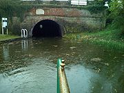
Traces of the old railway can still be seen, particularly towards Ticknall
. A low embankment, still with some stone sleeper blocks crosses a field and a tunnel passes under the drive to Calke Abbey
. There is also an arch bridge in Ticknall village where the line ran into the quarries.
 The closure of the canal north of Snarestone in 1966 led to the formation of the Ashby Canal Association
, to ensure that no more was closed and to work towards the reopening of the northern section. In 1992, the engineering consultants W. S. Atkins produced a feasibility study for the restoration of the canal between Snarestone and Moira, which concluded that there were no obstacles which could not be resolved. They also recommended that the reconstruction should be suitable for broad-beam boats, rather than 7 feet (2.1 m) narrow boats, as this would have ecological advantages. By 1997, Leicestershire County Council had bought much of the route, and had located two funding packages worth over £1 million. However, they failed to reach agreement with one landowner over the purchase of a parcel of land, and because the deadlines were not met, the funding was lost. They therefore resolved to obtain an order under the Transport and Works Act 1992
, which would allow them to use compulsory purchase powers if necessary. In order to promote and assist the restoration of the canal north of Snarestone, the Ashby Canal Trust
was set up in 2000. It is a limited company, with directors representing the Ashby Canal Association, British Waterways, Hinckley and Bosworth Borough Council, the Inland Waterways Association
, Leicestershire County Council and North West Leicestershire District Council.
Since the mining industry in the area has ceased, there have been fewer problems with subsidence, and the current plans are to re-open the canal to the National Forest
visitor centre at Moira, about 1 miles (1.6 km) short of its original terminus at Spring Cottage. Between 1999 and 2005, a stretch of the canal near Moira was restored and re-filled with water, passing the historic Moira Furnace
, a blast furnace from the 19th century which has been converted to provide visitor facilities including a craft centre, museum and cafe. The restored stretch is some 1.5 miles (2.4 km) long, and includes a new lock built to overcome the problems caused by mining subsidence. Below the restored section, the way forward has been blocked by the construction of the A42 main road
across the canal's formation. In November 2004, a public enquiry was held in connection with the application for a Transport and Works Order. Most objections were withdrawn, leaving one from English Nature
, which was accommodated by including a provision for off-line nature reserves, and the Order was granted in October 2005.
The Order allows Leicestershire County Council to purchase land and construct 2.5 miles (4 km) of canal from Snarestone to Measham. Initially, this will follow the original route, but will diverge near Measham, to use the track of a redundant railway. The new canal will pass through Measham Station and cross the High Street on an aqueduct. The Transport and Works Act Order was introduced by the British Parliament in 1992 as a way of simplifying the legal processes for railway and canal projects, and works which interfere with navigation rights. Although a number of railway projects had previously been authorised under this legislation, the Ashby Canal Order obtained by Leicestershire County Council was the first time that construction of a canal had been authorised in this way. Purchase of the land between Snarestone and Measham had been completed by 2010. Re-construction of the first 100 yards (91.4 m) of the infilled section began on 26 February 2009, after a grant from the East Midlands Development Agency was secured. The £0.5 million project involved the provision of stop gates, a new slipway, an improved winding hole and a wetland nature reserve, running parallel to the canal and connected to it. The stop lock marks the division between the part of the canal owned by British Waterways, and that owned by Leicestershire County Council.
Canal
Canals are man-made channels for water. There are two types of canal:#Waterways: navigable transportation canals used for carrying ships and boats shipping goods and conveying people, further subdivided into two kinds:...
in England which connected the mining district around Moira
Moira, Leicestershire
Moira is a former mining village about west of Ashby-de-la-Zouch in North West Leicestershire, England. The village is about miles south of the Derbyshire town of Swadlincote and is close to the county boundary....
, just outside the town of Ashby-de-la-Zouch
Ashby-de-la-Zouch
Ashby-de-la-Zouch, — Zouch being pronounced "Zoosh" — often shortened to Ashby, is a small market town and civil parish in North West Leicestershire, England, within the National Forest. It is twinned with Pithiviers in north-central France....
, with the Coventry Canal at Bedworth
Bedworth
Bedworth is a market town in the Nuneaton and Bedworth district of Warwickshire, England. It lies northwest of London, east of Birmingham, and north northeast of the county town of Warwick. It is situated between Coventry, to the south, and Nuneaton, to the north.In the 2001 census the town...
in Warwickshire
Warwickshire
Warwickshire is a landlocked non-metropolitan county in the West Midlands region of England. The county town is Warwick, although the largest town is Nuneaton. The county is famous for being the birthplace of William Shakespeare...
. It was opened in 1804, and a number of tramways were constructed at its northern end, to service collieries. The canal was taken over by the Midland Railway
Midland Railway
The Midland Railway was a railway company in the United Kingdom from 1844 to 1922, when it became part of the London, Midland and Scottish Railway....
in 1846, but remained profitable until the 1890s, after which it steadily declined. Around 9 miles (14.5 km) passed through the Leicestershire coal field, and was heavily affected by subsidence, with the result that this section from Moira, southwards to Snarestone
Snarestone
Snarestone is a small rural village in North West Leicestershire, England.It lies on the edge of the National Forest and is from the market town of Ashby-de-la-Zouch. It has a population of approximately 300 people and 120 households....
, was progressively closed in 1944, 1957 and 1966, leaving 22 miles (35.4 km) of navigable canal.
The abandoned section is the subject of a restoration project and is the first canal where a new section has been authorised under the Transport and Works Act 1992
Transport and Works Act 1992
The Transport and Works Act 1992 was established by the Parliament of the United Kingdom to provide a system by which the construction of rail transport, tramway, inland waterway and harbour infrastructure could proceed in the UK by order of the Minister of State for Transport rather than, as...
. The Transport and Works Order was obtained by Leicestershire County Council, as some of the original route has been infilled and built over, and restoration therefore involves construction on a new route through the centre of Measham
Measham
Measham is a village in Leicestershire, near the Staffordshire and Derbyshire border, located just off the A42 just south of Ashby-de-la-Zouch, and within the National Forest...
. It is hoped that all but the final 1 miles (1.6 km) section of the canal can be re-opened. An isolated section near Moira Furnace and the National Forest
National Forest, England
The National Forest is one of England’s most ambitious environmental projects. Across parts of Leicestershire, Derbyshire and Staffordshire, are being transformed, blending ancient woodland with new planting to create a new national forest...
visitor centre was opened between 1999 and 2005, and is the location for an annual trailboat festival.
Route
The canal starts at a junction with the Coventry CanalCoventry Canal
The Coventry Canal is a navigable narrow canal in the Midlands of England.It starts in Coventry and ends 38 miles north at Fradley Junction, just north of Lichfield, where it joins the Trent and Mersey Canal...
just outside Bedworth and travels north-east for about 7 miles (11 km) through the town of Hinckley
Hinckley
Hinckley is a town in southwest Leicestershire, England. It has a population of 43,246 . It is administered by Hinckley and Bosworth Borough Council...
. It then continues to run north through largely rural and remote countryside for another 15 miles (24 km) until reaching its terminus at Snarestone. Near Sutton Cheney
Sutton Cheney
Sutton Cheney is a village in Leicestershire, England, close to the location of the Battle of Bosworth Field.Sutton Cheney Wharf on the Ashby Canal gives access to the battlefield and is a tourist destination in its own right...
Wharf, it passes the foot of Ambion Hill
Ambion Hill
Ambion Hill is the hill in Leicestershire, England near the town of Market Bosworth where, traditionally, the Battle of Bosworth Field is supposed to have been fought. This has been disputed by historians and research has been started to ascertain the truth about what was called, at the time, the...
, the site of the Battle of Bosworth Field
Battle of Bosworth Field
The Battle of Bosworth Field was the penultimate battle of the Wars of the Roses, the civil war between the House of Lancaster and the House of York that raged across England in the latter half of the 15th century. Fought on 22 August 1485, the battle was won by the Lancastrians...
. At Shackerstone
Shackerstone
Shackerstone is a village and civil parish in the Hinckley and Bosworth district of Leicestershire, England. It is situated on the Ashby-de-la-Zouch Canal and the River Sence. According to the 2001 census the parish, which also includes the village of Barton in the Beans, had a population of...
, it passes the station that is the HQ of the Battlefield Line Railway
Battlefield Line Railway
The Battlefield Line Railway is a heritage railway in Leicestershire, England. It runs from Shackerstone to Shenton , via Market Bosworth, a total of...
.
Origins
In the last half of the eighteenth century there had been an increasing need for transport to exploit the coalCoal
Coal is a combustible black or brownish-black sedimentary rock usually occurring in rock strata in layers or veins called coal beds or coal seams. The harder forms, such as anthracite coal, can be regarded as metamorphic rock because of later exposure to elevated temperature and pressure...
reserves at Ashby Wolds and lime
Lime (mineral)
Lime is a general term for calcium-containing inorganic materials, in which carbonates, oxides and hydroxides predominate. Strictly speaking, lime is calcium oxide or calcium hydroxide. It is also the name for a single mineral of the CaO composition, occurring very rarely...
from the quarries north of Ashby-de-la-Zouch. The first proposal was for a canal running from Burton-on-Trent on the upper River Trent
River Trent
The River Trent is one of the major rivers of England. Its source is in Staffordshire on the southern edge of Biddulph Moor. It flows through the Midlands until it joins the River Ouse at Trent Falls to form the Humber Estuary, which empties into the North Sea below Hull and Immingham.The Trent...
to Marston
Marston
Marston is the name of several places in the United Kingdom:*Marston, Cheshire*Marston, Herefordshire*Marston, Lincolnshire*Marston, Oxfordshire*Marston, Brewood, Staffordshire*Marston, Stafford, Staffordshire*Marston, Warwickshire*Marston, Wiltshire...
on the Coventry Canal
Coventry Canal
The Coventry Canal is a navigable narrow canal in the Midlands of England.It starts in Coventry and ends 38 miles north at Fradley Junction, just north of Lichfield, where it joins the Trent and Mersey Canal...
. A second suggestion was for a canal from Ashby Wolds to the Coventry Canal at Griff. Both proposals were made in December 1781. The first was opposed by the Coventry company, though the second was not. Robert Whitworth had estimated the cost of the project at £46,396, but the scheme was dropped a year later. William Jessop
William Jessop
William Jessop was an English civil engineer, best known for his work on canals, harbours and early railways in the late 18th and early 19th centuries.-Early life:...
proposed a canal and tramway between Breedon and the Trent, with a connecting link to the Trent and Mersey Canal
Trent and Mersey Canal
The Trent and Mersey Canal is a in the East Midlands, West Midlands, and North West of England. It is a "narrow canal" for the vast majority of its length, but at the extremities—east of Burton upon Trent and west of Middlewich—it is a wide canal....
in 1787, which also came to nothing. A proposal in 1790 was well received at the time, but opposition afterwards prevented a bill being submitted to Parliament. Another proposal for a canal northwards to the Trent at Burton was actively discussed between 1791 and 1793. There was wide support for a canal to Griff in 1792, but the muted support of Penn Assheton Curzon, a local landowner and Member of Parliament, led to it being dropped.
In October 1792, Robert Whitworth revised his plan from 1781. The proposal featured a level canal from Griff, near Nuneaton
Nuneaton
Nuneaton is the largest town in the Borough of Nuneaton and Bedworth and in the English county of Warwickshire.Nuneaton is most famous for its associations with the 19th century author George Eliot, who was born on a farm on the Arbury Estate just outside Nuneaton in 1819 and lived in the town for...
, to Ashby Wolds, which would cost £63,402. From there it would climb 139 feet (42.4 m) to a summit which would be supplied with water by a steam pumping engine. After a further 5 miles (8 km), the summit level would descend through 84 feet (25.6 m) to level branches, which would serve collieries at Ticknall
Ticknall
Ticknall is a small village and civil parish in South Derbyshire, England. Situated on the A514 road, close to Melbourne, it has three pubs, several small businesses, and a primary school. Two hundred years ago it was considerably larger and noisier with lime quarries, tramways and potteries. Coal...
, Coleorton
Coleorton
Coleorton is a village and civil parish in North West Leicestershire, England. It is situated on the A512 road approximately 2 miles east of Ashby de la Zouch...
, Cloud Hill, near Breedon-on-the-Hill, and Staunton Harold. The cost of this section would be £82,143. The plans were checked by Jessop, and formed the basis for a bill
Bill (proposed law)
A bill is a proposed law under consideration by a legislature. A bill does not become law until it is passed by the legislature and, in most cases, approved by the executive. Once a bill has been enacted into law, it is called an act or a statute....
to authorise a company with powers to raise £150,000 of capital. Hard negotitation with Curzon and the Coventry Canal was required, during which the junction with the Coventry Canal was moved from Griff to Marston, but the bill finally became an Act of Parliament
Act of Parliament
An Act of Parliament is a statute enacted as primary legislation by a national or sub-national parliament. In the Republic of Ireland the term Act of the Oireachtas is used, and in the United States the term Act of Congress is used.In Commonwealth countries, the term is used both in a narrow...
in May 1794. Whitworth and his son, also called Robert, were appointed as engineers in July, and construction began. (Robert Whitworth was later remembered with the naming in 2002 of Whitworth Avenue on the new George Wimpey development in Hinckley, which overlooks the Ashby Canal).
Construction
By October 1796, it had become obvious that the costs of construction had been seriously underestimated. In addition, around one quarter of the shareholders had not honoured their pledges, and so the company had less capital than expected. The company decided that the only solution was to replace the branch canals with tramways. For a brief time at the start of 1797, the company investigated the possibility of extending the canal to the River Trent at Burton-on-Trent, and building tramways from the quarries to the river. Amalgamation with the Trent Navigation was considered, but the plans failed due to the lack of capital. In May 1797, Robert Whitworth Jr. became ill, and the Whitworths were replaced by Thomas Newbold. An investigation at that time into the state of the collieries at Ashby Wolds revealed that they were unlikely to be producing coal by the time the canal opened. By March the following year, the top section from Ashby Wolds to Market Bosworth was operational.The company had been considering the option of building tramways since 1793, and finally asked Newbold to investigate the possible lines for railways which would serve the canal at Ashby Wolds in June 1798. They then asked Benjamin Outram
Benjamin Outram
Benjamin Outram was an English civil engineer, surveyor and industrialist. He was a pioneer in the building of canals and tramways.-Personal life:...
to advise, and he reported in September. He suggested running the lines to Willesley
Willesley
Willesley is a place near Ashby-de-la-Zouch. It was in Derbyshire but is now part of Leicestershire. In the 19th century it had a population of about 60 and Willesley Hall was the home of the Abney and later the Abney-Hastings family. Willesley is so small that it would be a hamlet except that it...
Basin rather than Ashby Wolds, as this route would cost over £8,000 less. The lines as built ran from the basin through Ashby to a junction at Old Parks, where one branch ran through Lount
Lount
Lount is a small village near Ashby-De-La-Zouch in north-west Leicestershire, England. It has a population of 50 . It has no local amenities apart from a public house. The village straddles the B587 road and is situated near to the A42 road....
to Cloud Hill, replacing the proposed canal and its diversion through Coleorton. The other branch led from Old Parks to Ticknall, with branches to the quarries between Calke Abbey
Calke Abbey
Calke Abbey is a Grade I listed country house near Ticknall, Derbyshire, England, in the care of the charitable National Trust.The site was an Augustinian priory from the 12th century until its dissolution by Henry VIII...
and Staunton Harold
Staunton Harold
Staunton Harold is a civil parish in North West Leicestershire about north of Ashby-de-la-Zouch. The parish is on the county boundary with Derbyshire and about south of Derby....
. The total length of the lines was around 12.5 miles (20 km).
In 1799, Outram had discussions with the company about the gauge of the tramways, and although lines at Crich and for the Derby Canal
Derby Canal
The Derby Canal ran from the Trent and Mersey Canal at Swarkestone to Derby and Little Eaton, and to the Erewash Canal at Sandiacre, Derbyshire, England. The canal gained its Act of Parliament in 1793 and was fully completed in 1796...
used a gauge of three feet six inch (1068 mm), he recommended that it should be made wider, at four feet two inches (1322 mm), forecasting that, within a few years, railways would be the principal mode of transport for merchandise. The wider gauge would increase the cost of tunnels and bridges, but only by £785 on a final contract price of £29,500. His quotation was accepted, although repeated requests by Outram for his contract to be signed were ignored.
Outram's engineer for the line was John Hodgkinson who was experienced in the work, but problems arose because the committee insisted that it should proceed on all sections of the line simultaneously, which made supervision difficult. Moreover, perennially short of money, they were dilatory in making decisions and providing funds, which caused Outram problems at his Butterley Works
Butterley Company
Butterley Engineering was an engineering company based in Ripley, Derbyshire. The company was formed from the Butterley Company which began as Benjamin Outram and Company in 1790 and existed until 2009.-Origins:...
as he was having to refuse contracts, so that he could be ready to provide the canal with material, as and when it was authorised. During this period of delay, the labour costs and the price of iron also rose. Even though Outram's experience of his treatment by the canal proprietors must have spoilt his satisfaction on the completion of the lines, they were arguably a major achievement and a model for railways in the future.
Later history
If 1823, there were calls for tramways to be built from the head of the canal to Swadlincote
Swadlincote
Swadlincote is a town and unparished area in South Derbyshire, about southeast of Burton-upon-Trent and about south of Derby. It is the main town of South Derbyshire and the seat of South Derbyshire District Council....
and Church Gresley
Church Gresley
Church Gresley is a village and former civil parish in the South Derbyshire district of Derbyshire, England. The village is very close to the town of Swadlincote, between the town and Castle Gresley. According to the 2001 census the parish had a population of 4,805.The toponym "Gresley" is derived...
. It took the committee two and a half years to decide to proceed, and the 3 miles (4.8 km) Swadlincote Railway was opened on 21 July 1827. It was built with double tracks, and used edge rails, similar to modern railways, rather than the "L"-shaped tram plates of the Willesley system. The cost of £4,262 was financed by a mortgage, which was paid off less than a year after opening. The Ticknall branch was extended in 1829, when a line from it to Dimsdale was authorised and built. The Coleorton Railway, which was run by an independent company, and used edge rails, opened in 1833. Negotiations between the two companies resulted in a connecting line being built between Cloud Hill and Worthington Rough
Worthington, Leicestershire
Worthington is a village and civil parish in North West Leicestershire, England, about north of the town of Coalville and a similar distance north-east of the market town of Ashby-de-la-Zouch. The village is about from East Midlands Airport and junction 23a of the M1 motorway where it meets the...
, which used a type of rail called a "rib rail", where the vertical flange of Outram's "L"-shaped rail was made much wider, so that wagons with flanged wheels could use it as an edge rail. The Ashby engineer was asked to prepare a quotation for the conversion of the entire Willesley system to rib rails in 1837, but there is no record as to whether this work was carried out.
Railway ownership
In 1845, the Midland RailwayMidland Railway
The Midland Railway was a railway company in the United Kingdom from 1844 to 1922, when it became part of the London, Midland and Scottish Railway....
were planning to build the Atherstone
Atherstone
Atherstone is a town in Warwickshire, England. The town is located near the northernmost tip of Warwickshire, close to the border with Staffordshire and Leicestershire and is the administrative headquarters of the borough of North Warwickshire.-History:...
, Ashby-de-la-Zouch and Burton-on-Trent railway, and offered to buy the canal for £110,000. They agreed to maintain the canal until the railway was built, but there was no longer-term agreement on its furture. Since most of the coal which used the canal travelled onwards via the Coventry Canal and the Oxford Canal, these companies faced a big drop in toll revenues, and fought hard to get the Midland Railway's bill amended. As well as a commitment to maintaining the canal, they also had a clause added which allowed the Coventry Canal to undertake maintenance and charge the railway for the work if the railway company failed in their obligations. An Act of Parliament was passed in 1846, which authorised the takeover, but the railway line as envisioned was not built. It was nearly 30 years later that serious railway competition arrived, when the London and North Western Railway
London and North Western Railway
The London and North Western Railway was a British railway company between 1846 and 1922. It was created by the merger of three companies – the Grand Junction Railway, the London and Birmingham Railway and the Manchester and Birmingham Railway...
and the Midland Railway jointly opened the Ashby and Nuneaton Joint Railway
Ashby and Nuneaton Joint Railway
The Ashby and Nuneaton Joint Railway was a pre-grouping railway company in the English Midlands. It was jointly owned by the Midland Railway and the London and North Western Railway and linked Nuneaton and Coalville....
from Overseal
Overseal
Overseal is a village situated 3 miles south of Swadlincote, in South Derbyshire. It is sometimes locally pronounced as "Ovversale" and is the southernmost settlement in Derbyshire, on the border with Leicestershire.-Geography:...
to Nuneaton
Nuneaton railway station
Nuneaton railway station serves the large town of Nuneaton in Warwickshire, England. The station is managed by London Midland.It is situated at the point where the Birmingham - Leicester route crosses the Trent Valley Line section of the West Coast Main Line north of London Euston, with a branch...
in 1873. The following year, the Midland reused the section of tramway from Ashby
Ashby-de-la-Zouch
Ashby-de-la-Zouch, — Zouch being pronounced "Zoosh" — often shortened to Ashby, is a small market town and civil parish in North West Leicestershire, England, within the National Forest. It is twinned with Pithiviers in north-central France....
to Worthington, Leicestershire
Worthington, Leicestershire
Worthington is a village and civil parish in North West Leicestershire, England, about north of the town of Coalville and a similar distance north-east of the market town of Ashby-de-la-Zouch. The village is about from East Midlands Airport and junction 23a of the M1 motorway where it meets the...
, enlarging the Old Parks tunnel, as part of a line that ran through Melbourne
Melbourne, Derbyshire
Melbourne is a Georgian market town in South Derbyshire, England. It is about 8 miles south of Derby and 2 miles from the River Trent. In 1837 a then tiny settlement in Australia was named after William Lamb, 2nd Viscount Melbourne, Queen Victoria's first Prime Minister, and thus indirectly takes...
to Derby. The remainder of the tramway lines were kept for local use, with the branch to Ticknall
Ticknall
Ticknall is a small village and civil parish in South Derbyshire, England. Situated on the A514 road, close to Melbourne, it has three pubs, several small businesses, and a primary school. Two hundred years ago it was considerably larger and noisier with lime quarries, tramways and potteries. Coal...
closing in 1915.
The canal continued to carry significant tonnages, which gradually decreased, from 138,117 tons in 1862 to 113,659 tons in 1882. After that, the decline was more rapid, dropping to 33,329 tons by 1893. By the 1890s, the railway owners had reduced maintenance on the canal, knowing that the Coventry Canal were unlikely to invoke their powers under the 1846 Act, since they too were in trouble. On 2 January 1918, there was a major breach in the canal when an embankment some 2 miles (3.2 km) below Moira collapsed. The cost of reinstatement was £9,864, and the canal reopened on 23 July 1919. The upper section was increasingly affected by subsidence from the coal mining. Despite this, the Moira Coal Company shipped 20,807 tons along the canal in 1943, and the total tonnage on the canal that year was 43,733 tons. The owners, by now the London, Midland and Scottish Railway
London, Midland and Scottish Railway
The London Midland and Scottish Railway was a British railway company. It was formed on 1 January 1923 under the Railways Act of 1921, which required the grouping of over 120 separate railway companies into just four...
(LMS), tried to give the canal to the Coventry Canal company in 1944, but they refused it unless there was money to fund the maintenance. The 2.5 miles (4 km) section from Moira to Donisthorpe was promptly abandoned, allowing the Moira Coal Company to mine under its course. Another 5 miles (8 km) were closed in 1957, under an Act of Parliament obtained by the British Transport Commission, and the Measham to Snarestone section was closed in 1966, even though coal was regularly loaded there.
Traces of the old railway can still be seen, particularly towards Ticknall
Ticknall
Ticknall is a small village and civil parish in South Derbyshire, England. Situated on the A514 road, close to Melbourne, it has three pubs, several small businesses, and a primary school. Two hundred years ago it was considerably larger and noisier with lime quarries, tramways and potteries. Coal...
. A low embankment, still with some stone sleeper blocks crosses a field and a tunnel passes under the drive to Calke Abbey
Calke Abbey
Calke Abbey is a Grade I listed country house near Ticknall, Derbyshire, England, in the care of the charitable National Trust.The site was an Augustinian priory from the 12th century until its dissolution by Henry VIII...
. There is also an arch bridge in Ticknall village where the line ran into the quarries.
Restoration
Ashby Canal Association
The Ashby Canal Association is a waterway society and a registered charity No. 1063566, in Leicestershire and Staffordshire, England, UK, concerned with the Ashby Canal, and affiliated to the Inland Waterways Association....
, to ensure that no more was closed and to work towards the reopening of the northern section. In 1992, the engineering consultants W. S. Atkins produced a feasibility study for the restoration of the canal between Snarestone and Moira, which concluded that there were no obstacles which could not be resolved. They also recommended that the reconstruction should be suitable for broad-beam boats, rather than 7 feet (2.1 m) narrow boats, as this would have ecological advantages. By 1997, Leicestershire County Council had bought much of the route, and had located two funding packages worth over £1 million. However, they failed to reach agreement with one landowner over the purchase of a parcel of land, and because the deadlines were not met, the funding was lost. They therefore resolved to obtain an order under the Transport and Works Act 1992
Transport and Works Act 1992
The Transport and Works Act 1992 was established by the Parliament of the United Kingdom to provide a system by which the construction of rail transport, tramway, inland waterway and harbour infrastructure could proceed in the UK by order of the Minister of State for Transport rather than, as...
, which would allow them to use compulsory purchase powers if necessary. In order to promote and assist the restoration of the canal north of Snarestone, the Ashby Canal Trust
Ashby Canal Trust
The Ashby Canal Trust is a waterway society based at Measham, Swadlincote, Leicestershire, England, UK, and concerned with the restoration of a part of the Ashby Canal, also known as the Ashby-de-la-Zouch Canal....
was set up in 2000. It is a limited company, with directors representing the Ashby Canal Association, British Waterways, Hinckley and Bosworth Borough Council, the Inland Waterways Association
Inland Waterways Association
The Inland Waterways Association was formed in 1946 as a registered charity in the United Kingdom to campaign for the conservation, use, maintenance, restoration and sensitive development of British Canals and river navigations....
, Leicestershire County Council and North West Leicestershire District Council.
Since the mining industry in the area has ceased, there have been fewer problems with subsidence, and the current plans are to re-open the canal to the National Forest
National Forest, England
The National Forest is one of England’s most ambitious environmental projects. Across parts of Leicestershire, Derbyshire and Staffordshire, are being transformed, blending ancient woodland with new planting to create a new national forest...
visitor centre at Moira, about 1 miles (1.6 km) short of its original terminus at Spring Cottage. Between 1999 and 2005, a stretch of the canal near Moira was restored and re-filled with water, passing the historic Moira Furnace
Moira Furnace
Moira Furnace is a nineteenth-century iron-making blast furnace located in Moira, Leicestershire on the banks of the Ashby-de-la-Zouch Canal...
, a blast furnace from the 19th century which has been converted to provide visitor facilities including a craft centre, museum and cafe. The restored stretch is some 1.5 miles (2.4 km) long, and includes a new lock built to overcome the problems caused by mining subsidence. Below the restored section, the way forward has been blocked by the construction of the A42 main road
A42 road
The A42 is a major trunk road in the East Midlands region of the United Kingdom. It links junction 23A of the M1 motorway to junction 11 of the M42 motorway. The A42 is in effect a continuation of the M42, and its junctions are numbered accordingly....
across the canal's formation. In November 2004, a public enquiry was held in connection with the application for a Transport and Works Order. Most objections were withdrawn, leaving one from English Nature
English Nature
English Nature was the United Kingdom government agency that promoted the conservation of wildlife, geology and wild places throughout England between 1990 and 2006...
, which was accommodated by including a provision for off-line nature reserves, and the Order was granted in October 2005.
The Order allows Leicestershire County Council to purchase land and construct 2.5 miles (4 km) of canal from Snarestone to Measham. Initially, this will follow the original route, but will diverge near Measham, to use the track of a redundant railway. The new canal will pass through Measham Station and cross the High Street on an aqueduct. The Transport and Works Act Order was introduced by the British Parliament in 1992 as a way of simplifying the legal processes for railway and canal projects, and works which interfere with navigation rights. Although a number of railway projects had previously been authorised under this legislation, the Ashby Canal Order obtained by Leicestershire County Council was the first time that construction of a canal had been authorised in this way. Purchase of the land between Snarestone and Measham had been completed by 2010. Re-construction of the first 100 yards (91.4 m) of the infilled section began on 26 February 2009, after a grant from the East Midlands Development Agency was secured. The £0.5 million project involved the provision of stop gates, a new slipway, an improved winding hole and a wetland nature reserve, running parallel to the canal and connected to it. The stop lock marks the division between the part of the canal owned by British Waterways, and that owned by Leicestershire County Council.
Coordinates
See also
- Ashby Canal AssociationAshby Canal AssociationThe Ashby Canal Association is a waterway society and a registered charity No. 1063566, in Leicestershire and Staffordshire, England, UK, concerned with the Ashby Canal, and affiliated to the Inland Waterways Association....
- Ashby Canal TrustAshby Canal TrustThe Ashby Canal Trust is a waterway society based at Measham, Swadlincote, Leicestershire, England, UK, and concerned with the restoration of a part of the Ashby Canal, also known as the Ashby-de-la-Zouch Canal....
- Moira FurnaceMoira FurnaceMoira Furnace is a nineteenth-century iron-making blast furnace located in Moira, Leicestershire on the banks of the Ashby-de-la-Zouch Canal...
- WaterscapeWaterscapeWaterscape was set up in the summer of 2003 and is British Waterways leisure website, supported by the Environment Agency and the Broads Authority as an official information and leisure resource for inland waterways within the UK....