
Argostoli
Encyclopedia
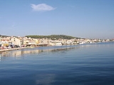
Argostoli is a town and a former municipality on the island of Kefalonia
, Ionian Islands
, Greece
. Since the 2011 local government reform it is part of the municipality Kefalonia
, of which it is a municipal unit. It has been the capital and administrative centre of Kefalonia since 1757, following a population shift down from the old capital of Agios Georgios (also known as Kastro) to take advantage of the trading opportunities provided by the sheltered bay upon which Argostoli sits. Argostoli developed in to one of the busiest ports in Greece
, leading to prosperity and growth. The 2001 census recorded a population of 12,589 in the Argostoli municipal unit. Its largest towns are Argostóli (pop. 9,037), Dilináta (739), Farakláta (411), and Kardakáta (362).
(Caretta caretta). Now a nature reserve, the Koutavos Lagoon was once an almost impassable swamp
where mosquito
es and malaria
were rife. Under the British governor of the island, General Sir Charles James Napier
, a wooden bridge was constructed across the lagoon
in 1813 by Colonel Charles Philip de Bosset, a Swiss engineer in the employ of the British army.
Four years later stone arches were added and, after some 26 years, the entire bridge was rebuilt in stone. In continuous use until 2005, this narrow bridge is now closed to traffic, awaiting renovation by the Greek Ministry of Culture. Almost halfway along the Drepano Bridge stands a stone column built by the British to celebrate their presence.
The coastal road out of Argostoli to the west was known during the Venetian period as the ‘Piccolo Gyro’. Along the Piccolo Gyro, in the Vlikha area facing Lixouri, lie the ‘Swallow Holes’ of Katovothres, a geological phenomenon. Sea water disappears underground and travels under the island, re-emerging some fourteen days later in the Karavomylos area of Sami, having passed through the nearby, underground Melissani lake. The power of this sea water was harnessed, in 1835, to power a water mill. Further along the Piccolo Gyro is the Agion Theodoron lighthouse, named after the small adjacent church. More commonly known as the Fanari lighthouse, this too was built during the British occupation, in 1829. The original building was destroyed in the earthquake of 1953, the recently restored present structure was rebuilt, complete with Doric-style columns, from the original plans.
Buildings that weren’t shattered by German bombing in 1943 were destroyed in 1953 by the earthquake
that razed virtually all of Kefalonia, apart from the Fiskardo
area, to the ground.
Opposite the Archaeological Museum of Argostoli are the law courts, originally constructed by the British with stone from the Cyclopean site at nearby Krani. Along Lithostroto, next to the Catholic Church, is a tiny museum (open some mornings and most evenings) dedicated to the soldiers of the Acqui Division. A little further along is the Bell Tower. Rebuilt in 1985 to house the original clock mechanism.
, Minies and ten former communities: Agona, Davgata, Dilinata, Zola, Thinia, Kourouklata, Nifi, Troyiannata, Faraklata and Farsa. This municipality, a municipal unit of the municipality of Kefalonia since 2011, was subdivided into the following municipal districts (communities since 2011). Constituent villages are given in brackets:
and Patras
. The old bus station, just past these market stalls, is likely to accommodate a proposed seaplane service connecting Argostoli with Patras
, due to commence Spring 2006. The main ferry port, connecting Argostoli with the mainland (via Kyllini
) and Zakynthos
(also known as Zante) is next to this building with the Lixouri ferry (once an hour in winter, twice an hour in summer) docking a little further along.
with:
Šabac
in Serbia
. Brăila
in Romania
.
Kefalonia
The island of Cephalonia, also known as Kefalonia, Cephallenia, Cephallonia, Kefallinia, or Kefallonia , is the largest of the Ionian Islands in western Greece, with an area of . It is also a separate regional unit of the Ionian Islands region, and the only municipality of the regional unit...
, Ionian Islands
Ionian Islands Periphery
Ionian Islands is one of the thirteen regions of Greece. It comprises the historical region of the Ionian Islands, except for the island of Kythera which belongs to Attica.-Administration:...
, Greece
Greece
Greece , officially the Hellenic Republic , and historically Hellas or the Republic of Greece in English, is a country in southeastern Europe....
. Since the 2011 local government reform it is part of the municipality Kefalonia
Kefalonia
The island of Cephalonia, also known as Kefalonia, Cephallenia, Cephallonia, Kefallinia, or Kefallonia , is the largest of the Ionian Islands in western Greece, with an area of . It is also a separate regional unit of the Ionian Islands region, and the only municipality of the regional unit...
, of which it is a municipal unit. It has been the capital and administrative centre of Kefalonia since 1757, following a population shift down from the old capital of Agios Georgios (also known as Kastro) to take advantage of the trading opportunities provided by the sheltered bay upon which Argostoli sits. Argostoli developed in to one of the busiest ports in Greece
Greece
Greece , officially the Hellenic Republic , and historically Hellas or the Republic of Greece in English, is a country in southeastern Europe....
, leading to prosperity and growth. The 2001 census recorded a population of 12,589 in the Argostoli municipal unit. Its largest towns are Argostóli (pop. 9,037), Dilináta (739), Farakláta (411), and Kardakáta (362).
Urban landscape
To the east of Argostoli, at the end of the bay, beneath the aforementioned Castle of St. George, sits the Koutavos Lagoon, a feeding ground for the Loggerhead turtlesLoggerhead sea turtle
The loggerhead sea turtle , or loggerhead, is an oceanic turtle distributed throughout the world. It is a marine reptile, belonging to the family Cheloniidae. The average loggerhead measures around long when fully grown, although larger specimens of up to have been discovered...
(Caretta caretta). Now a nature reserve, the Koutavos Lagoon was once an almost impassable swamp
Swamp
A swamp is a wetland with some flooding of large areas of land by shallow bodies of water. A swamp generally has a large number of hammocks, or dry-land protrusions, covered by aquatic vegetation, or vegetation that tolerates periodical inundation. The two main types of swamp are "true" or swamp...
where mosquito
Mosquito
Mosquitoes are members of a family of nematocerid flies: the Culicidae . The word Mosquito is from the Spanish and Portuguese for little fly...
es and malaria
Malaria
Malaria is a mosquito-borne infectious disease of humans and other animals caused by eukaryotic protists of the genus Plasmodium. The disease results from the multiplication of Plasmodium parasites within red blood cells, causing symptoms that typically include fever and headache, in severe cases...
were rife. Under the British governor of the island, General Sir Charles James Napier
Charles James Napier
General Sir Charles James Napier, GCB , was a general of the British Empire and the British Army's Commander-in-Chief in India, notable for conquering the Sindh Province in what is now Pakistan.- His genealogy :...
, a wooden bridge was constructed across the lagoon
Lagoon
A lagoon is a body of shallow sea water or brackish water separated from the sea by some form of barrier. The EU's habitat directive defines lagoons as "expanses of shallow coastal salt water, of varying salinity or water volume, wholly or partially separated from the sea by sand banks or shingle,...
in 1813 by Colonel Charles Philip de Bosset, a Swiss engineer in the employ of the British army.
Four years later stone arches were added and, after some 26 years, the entire bridge was rebuilt in stone. In continuous use until 2005, this narrow bridge is now closed to traffic, awaiting renovation by the Greek Ministry of Culture. Almost halfway along the Drepano Bridge stands a stone column built by the British to celebrate their presence.
The coastal road out of Argostoli to the west was known during the Venetian period as the ‘Piccolo Gyro’. Along the Piccolo Gyro, in the Vlikha area facing Lixouri, lie the ‘Swallow Holes’ of Katovothres, a geological phenomenon. Sea water disappears underground and travels under the island, re-emerging some fourteen days later in the Karavomylos area of Sami, having passed through the nearby, underground Melissani lake. The power of this sea water was harnessed, in 1835, to power a water mill. Further along the Piccolo Gyro is the Agion Theodoron lighthouse, named after the small adjacent church. More commonly known as the Fanari lighthouse, this too was built during the British occupation, in 1829. The original building was destroyed in the earthquake of 1953, the recently restored present structure was rebuilt, complete with Doric-style columns, from the original plans.
Buildings that weren’t shattered by German bombing in 1943 were destroyed in 1953 by the earthquake
1953 Ionian Earthquake
The Great 1953 Ionian Earthquake struck the southern Ionian Islands in Greece on August 12, 1953. In mid-August 1953, beginning on 8 August there were over 113 recorded earthquakes in the region between Kefalonia and Zakynthos, but the most destructive was the earthquake of August 12th...
that razed virtually all of Kefalonia, apart from the Fiskardo
Fiskardo
Fiskardo , lately, more commonly Fiscardo, is a village located about 54 km north of Argostoli and a district of the city of Erisos....
area, to the ground.
Opposite the Archaeological Museum of Argostoli are the law courts, originally constructed by the British with stone from the Cyclopean site at nearby Krani. Along Lithostroto, next to the Catholic Church, is a tiny museum (open some mornings and most evenings) dedicated to the soldiers of the Acqui Division. A little further along is the Bell Tower. Rebuilt in 1985 to house the original clock mechanism.
Subdivisions
Following the “Kapodistrias Law” of 1997, communities around the town united to form a larger municipality of Argostoli, which included the settlements of Spilia, Helmata, Kompothekrata, LassiLassi
Lassi is a popular and traditional yogurt-based drink of the Indian Subcontinent. It is made by blending yogurt with water and Indian spices...
, Minies and ten former communities: Agona, Davgata, Dilinata, Zola, Thinia, Kourouklata, Nifi, Troyiannata, Faraklata and Farsa. This municipality, a municipal unit of the municipality of Kefalonia since 2011, was subdivided into the following municipal districts (communities since 2011). Constituent villages are given in brackets:
- Agkonas
- Argostoli (Argostoli, Kokolata, Kompothekrata, Minia)
- DavgataDavgataDavgata is a small settlement in the island of Kefalonia and is also in the Potamana region in Greece. Davgata located 7 km north of Argostoli, WSW of Sami and northeast of the Argostoli-Fiskardo Road. Davgata is passed by the road linking the Argostoli-Fiskardo Road at aprooximately at the...
- DilinataDilinataDilinata is a small settlement located 9 km northeast of Argostoli, NW of Sami and north of the Argostoli-Sami Road and E of Davgata. Faraklata is passed by the road linking near Razata and Dilinata and is the point to the uneven road to Makriotika and also to Davgata and the western part...
- FaraklataFaraklataFaraklata is a small settlement located 6 km northeast of Argostoli, NW of Sami and north of the Argostoli-Sami Road . Faraklata is passed by the road linking near Razata and Dilinata and an uneven road to Makriotika. The village sits on a mountain and a valley areas and also has farmlands...
(Faraklata, Drapano, Prokopata, Razata) - FarsaFarsa, GreeceFarsa is a small settlement on the island of Kefalonia in the Potamana region in Greece. Farsata is located 8 kilometer north of Argostoli, east of Lixouri and south of Fiskardo. It is linked with the Argostoli-Fiskardo Road at approximately at the 8th km. Farsa is situated on a mountain slope and...
- Thinaia (Kardakata)
- Kourouklata
- Nyfi
- TroianataTroianataTroianata is a village located 11 km ESE of Argostoli and about 41 km W of Poros in the municipal unit of Argostoli on the island of Kefalonia...
(Troianata, DemoutsanataDemoutsanataDemoutsanata is a village in the municipal unit of Argostoli on the island of Kefalonia, Greece. It is part of the community of Troianata. It is located 10 km ESE of Argostoli and about 40 km W of Poros. Until the twentieth century, the village was known as Montesanata and was named after...
, MitakataMitakataMitakata is a village in the municipality of Argostoli, on the island of Kefalonia, Greece. Mitakata is linked with the road linking Travliata and Michata and are surrounded by the hills of Omalon with a taller one to the east and smaller hilltops elsewhere...
) - Zola
Transportation
Between the Koutavos Lagoon and the Drepano Bridge is the new bus station which connects Argostoli with the other towns and some of the villages on the island, as well as with AthensAthens
Athens , is the capital and largest city of Greece. Athens dominates the Attica region and is one of the world's oldest cities, as its recorded history spans around 3,400 years. Classical Athens was a powerful city-state...
and Patras
Patras
Patras , ) is Greece's third largest urban area and the regional capital of West Greece, located in northern Peloponnese, 215 kilometers west of Athens...
. The old bus station, just past these market stalls, is likely to accommodate a proposed seaplane service connecting Argostoli with Patras
Patras
Patras , ) is Greece's third largest urban area and the regional capital of West Greece, located in northern Peloponnese, 215 kilometers west of Athens...
, due to commence Spring 2006. The main ferry port, connecting Argostoli with the mainland (via Kyllini
Kyllini
There are several places on the Peloponnesus peninsula in Greece named Kyllíni :* Mount Kyllini , the mythological birthplace of Hermes ....
) and Zakynthos
Zakynthos
Zakynthos , also Zante, the other form often used in English and in Italian , is a Greek island in the Ionian Sea. It is the third largest of the Ionian Islands. It is also a separate regional unit of the Ionian Islands region, and the only municipality of the regional unit. It covers an area of ...
(also known as Zante) is next to this building with the Lixouri ferry (once an hour in winter, twice an hour in summer) docking a little further along.
- Car ferry service to KylliniKylliniThere are several places on the Peloponnesus peninsula in Greece named Kyllíni :* Mount Kyllini , the mythological birthplace of Hermes ....
(mainland) and ZakynthosZakynthosZakynthos , also Zante, the other form often used in English and in Italian , is a Greek island in the Ionian Sea. It is the third largest of the Ionian Islands. It is also a separate regional unit of the Ionian Islands region, and the only municipality of the regional unit. It covers an area of ...
(Zante) - Car ferry to LixouriLixouriLixouri is the main town on the peninsula of Paliki in the island of Kefalonia, one of the Ionian Islands of western Greece. Lixouri is the second largest community in Kefalonia after Argostoli and before Sami and is the capital of the small peninsula...
- KTEL Bus service to AthensAthensAthens , is the capital and largest city of Greece. Athens dominates the Attica region and is one of the world's oldest cities, as its recorded history spans around 3,400 years. Classical Athens was a powerful city-state...
, via KylliniKylliniThere are several places on the Peloponnesus peninsula in Greece named Kyllíni :* Mount Kyllini , the mythological birthplace of Hermes ....
, PatrasPatrasPatras , ) is Greece's third largest urban area and the regional capital of West Greece, located in northern Peloponnese, 215 kilometers west of Athens...
and the Corinth CanalCorinth CanalThe Corinth Canal is a canal that connects the Gulf of Corinth with the Saronic Gulf in the Aegean Sea. It cuts through the narrow Isthmus of Corinth and separates the Peloponnesian peninsula from the Greek mainland, thus effectively making the former an island. The builders dug the canal through...
bridge - Infrequent bus service to PorosPoros (Kefalonia), GreecePoros , is a picturesque small town located in the municipal unit of Eleios-Pronnoi, some 40 km SE of Argostoli, 28 km SE of Sami and 12 km NE of Skala, in the southeast of Cephalonia, one of the Ionian Islands of Greece.-Geography:...
, Sami, SkalaSkala (Kefalonia), GreeceSkala is a picturesque village located in the municipal unit of Eleios-Pronnoi, some 39 km south from the island's main town of Argostoli and 14 km SW of Poros, in the south of Cephalonia, one of the Ionian Islands of Greece....
, Fiskardo and various villages en route - Frequent summer service to LassiLassiLassi is a popular and traditional yogurt-based drink of the Indian Subcontinent. It is made by blending yogurt with water and Indian spices...
- NO bus service to Kefalonia Airport
- Scheduled flights to Zakynthos and Athens, charter flight in summer, via Kefalonia AirportKefalonia Island International AirportCephalonia International Airport is an airport on the island of Cephalonia, in Greece.The airport opened in 1971 to serve the former municipality Leivathos with improved transportation links; Cephalonia is now a single municipality. A new runway and the current terminal building were constructed...
- Seaplane service, Argostoli - Patras (due Spring 2006)
- Taxis from Plateia Valianos and seafront, car and motorcycle/scooter hire
Historical population
| Year | Town population | Municipality population |
|---|---|---|
| 1981 | 7,164 | - |
| 1991 | 7,420 | 9,918 |
| 2001 | 9,522 | 12,589 |
People
- Gerasimos ArsenisGerasimos ArsenisGerasimos Arsenis , is a Greek politician who served as a Member of the Hellenic Parliament and a Minister, in several Governments with the Panhellenic Socialist Movement.-Life:...
, politician - Aris MaliagrosAris MaliagrosAris Maliagros was a Greek actor who played several aristocratic roles as Giorgos Gavriilidis and Hristos Tsaganeas...
(1895–1984), actor - Andreas MetaxasAndreas MetaxasAndreas Metaxas was a Greek politician born on the island of Cephalonia.During the latter part of the War of Independence he accompanied Kapodistrias to Greece, and was appointed by him Minister of War...
(1786–1860), politician - Ioannis MetaxasIoannis MetaxasIoannis Metaxas was a Greek general, politician, and dictator, serving as Prime Minister of Greece from 1936 until his death in 1941...
(1871–1941), general, politician and dictator - Constantine PhaulkonConstantine PhaulkonConstantine Phaulkon was a Greek adventurer, who became first counsellor to King Narai of Ayutthaya.Born on the Ionian island of...
(1647–1688), merchant and adventurer - Antonis TritsisAntonis TritsisAntonis Tritsis was a Greek politician and urban planner, born and raised in the town of Argostoli on the island of Kefalonia.A founding member of PASOK, he was elected MP in the Greek Parliament with PASOK in 1981 and 1985 and served as Minister of Urban Planning, and Minister for National...
(1937–1992), mayor of Athens - Christian ZervosChristian ZervosChristian Zervos . French art collector, writer and publisher.Better known as a publisher of books than as an art critic in his own right, Zervos founded the magazine Cahiers d'art in Paris, and ran an art gallery.He was a connoisseur of modern painting in his time, and of Greek art and...
(1889–1970), art collector, writer and publisher
International relations
Argostoli is twinnedTown twinning
Twin towns and sister cities are two of many terms used to describe the cooperative agreements between towns, cities, and even counties in geographically and politically distinct areas to promote cultural and commercial ties.- Terminology :...
with:
Šabac
Šabac
Šabac is a city and municipality in western Serbia, along the Sava river, in the historic region of Mačva. It is the administrative center of the Mačva District. The city has a population of 52,822 , while population of the municipality is 115,347...
in Serbia
Serbia
Serbia , officially the Republic of Serbia , is a landlocked country located at the crossroads of Central and Southeast Europe, covering the southern part of the Carpathian basin and the central part of the Balkans...
. Brăila
Braila
Brăila is a city in Muntenia, eastern Romania, a port on the Danube and the capital of Brăila County, in the close vicinity of Galaţi.According to the 2002 Romanian census there were 216,292 people living within the city of Brăila, making it the 10th most populous city in Romania.-History:A...
in Romania
Romania
Romania is a country located at the crossroads of Central and Southeastern Europe, on the Lower Danube, within and outside the Carpathian arch, bordering on the Black Sea...
.