Angel Lake
Encyclopedia
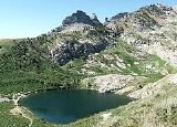
Angel Lake is a glacial tarn
in the northern part of the East Humboldt Range
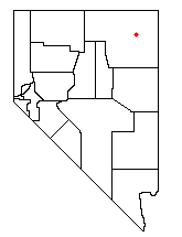
, in central Elko County
in the northeastern part of the state of Nevada
. It is located at approximately 41°01.6′N 115°05.1′W, and at an elevation of 8378 feet (2553 m). It has an area of approximately 13 acres (5.2 hectares), and a depth of up to 29 feet (9 m). A 12 miles (19.3 km) scenic highway, State Route 231
, climbs from Interstate 80's exit 351 in Wells
to the eastern shore of the lake.
Located at the base of a steep cirque
, the lake is surrounded by high granite cliffs. Greys Peak
(10,674 ft, 3253 m) rises high to the west, and to the south is a group of pinnacles
known as Chimney Rock. Far below and to the east lies Clover Valley and the community of Wells
.
Angel Lake is one of the most popular recreation sites in the area. On its shore is a 26-site campground, and an 11-site picnic area. The lake itself is available for fishing and non-motorized rafts. A paved trailhead provides access for routes to nearby Smith Lake and to the more distant Greys Lake. Down the access road can be found a trailhead for Winchell Lake, and the Angel Creek Campground.
The lake was named after Warren M. Angel, an early rancher in nearby Clover Valley.

Tarn (lake)
A tarn is a mountain lake or pool, formed in a cirque excavated by a glacier. A moraine may form a natural dam below a tarn. A corrie may be called a cirque.The word is derived from the Old Norse word tjörn meaning pond...
in the northern part of the East Humboldt Range
East Humboldt Range
The East Humboldt Range is a line of mountains in northeastern Nevada in the Great Basin region of the western United States. It located in central Elko County in the upper watershed of the Humboldt River, which flows to the southwest from its source just north of the range.The East Humboldts run...
, in central Elko County
Elko County, Nevada
-Demographics:As of the census of 2000, there were 45,291 people, 15,638 households, and 11,493 families residing in the county. The population density was 3/sq mi . There were 18,456 housing units at an average density of 1/sq mi...
in the northeastern part of the state of Nevada
Nevada
Nevada is a state in the western, mountain west, and southwestern regions of the United States. With an area of and a population of about 2.7 million, it is the 7th-largest and 35th-most populous state. Over two-thirds of Nevada's people live in the Las Vegas metropolitan area, which contains its...
. It is located at approximately 41°01.6′N 115°05.1′W, and at an elevation of 8378 feet (2553 m). It has an area of approximately 13 acres (5.2 hectares), and a depth of up to 29 feet (9 m). A 12 miles (19.3 km) scenic highway, State Route 231
Nevada State Route 231
Angel Lake Road is a state highway in Elko County, Nevada, USA. It serves to connect Interstate 80 in Wells to nearby Angel Lake in the north of the East Humboldt Range....
, climbs from Interstate 80's exit 351 in Wells
Wells, Nevada
Wells is a city in Elko County, in northeast Nevada in the western United States. The population was 1,346 at the 2000 census. Wells is located at the junction of U.S. Route 93 and Interstate 80, approximately east of Elko and is part of the Elko Micropolitan Statistical Area.-History:The site...
to the eastern shore of the lake.
Located at the base of a steep cirque
Cirque (landform)
thumb|250 px|Two cirques with semi-permanent snowpatches in [[Abisko National Park]], [[Sweden]].A cirque or corrie is an amphitheatre-like valley head, formed at the head of a valley glacier by erosion...
, the lake is surrounded by high granite cliffs. Greys Peak
Greys Peak
Greys Peak is the northernmost summit of the East Humboldt Range of Elko County in northeastern Nevada about southwest of the community of Wells. It rises over from the Humboldt Valley, making it one of the most visually prominent peaks in the area...
(10,674 ft, 3253 m) rises high to the west, and to the south is a group of pinnacles
Arete (landform)
thumb|right|[[Clouds Rest]] in [[Yosemite National Park]] is an arete.An arête is a thin, almost knife-like, ridge of rock which is typically formed when two glaciers erode parallel U-shaped valleys. The arête is a thin ridge of rock that is left separating the two valleys...
known as Chimney Rock. Far below and to the east lies Clover Valley and the community of Wells
Wells, Nevada
Wells is a city in Elko County, in northeast Nevada in the western United States. The population was 1,346 at the 2000 census. Wells is located at the junction of U.S. Route 93 and Interstate 80, approximately east of Elko and is part of the Elko Micropolitan Statistical Area.-History:The site...
.
Angel Lake is one of the most popular recreation sites in the area. On its shore is a 26-site campground, and an 11-site picnic area. The lake itself is available for fishing and non-motorized rafts. A paved trailhead provides access for routes to nearby Smith Lake and to the more distant Greys Lake. Down the access road can be found a trailhead for Winchell Lake, and the Angel Creek Campground.
The lake was named after Warren M. Angel, an early rancher in nearby Clover Valley.


