
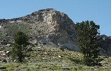
Greys Peak
Encyclopedia
Greys Peak is the northernmost summit of the East Humboldt Range
of Elko County
in northeastern Nevada
about 10 miles (16.1 km) southwest of the community of Wells
. It rises over 5000 foot from the Humboldt Valley
, making it one of the most visually prominent peaks in the area. To the west are Dennis Flats, Starr Valley, and remote Greys Lake, while to the east are Chimney Rock, Clover Valley, and popular Angel Lake
. The summit is the start of a high crest running almost 10 miles (16.1 km) to the south.
The peak is named after Enoch Grey, an early homesteader in nearby Starr Valley.
East Humboldt Range
The East Humboldt Range is a line of mountains in northeastern Nevada in the Great Basin region of the western United States. It located in central Elko County in the upper watershed of the Humboldt River, which flows to the southwest from its source just north of the range.The East Humboldts run...
of Elko County
Elko County, Nevada
-Demographics:As of the census of 2000, there were 45,291 people, 15,638 households, and 11,493 families residing in the county. The population density was 3/sq mi . There were 18,456 housing units at an average density of 1/sq mi...
in northeastern Nevada
Nevada
Nevada is a state in the western, mountain west, and southwestern regions of the United States. With an area of and a population of about 2.7 million, it is the 7th-largest and 35th-most populous state. Over two-thirds of Nevada's people live in the Las Vegas metropolitan area, which contains its...
about 10 miles (16.1 km) southwest of the community of Wells
Wells, Nevada
Wells is a city in Elko County, in northeast Nevada in the western United States. The population was 1,346 at the 2000 census. Wells is located at the junction of U.S. Route 93 and Interstate 80, approximately east of Elko and is part of the Elko Micropolitan Statistical Area.-History:The site...
. It rises over 5000 foot from the Humboldt Valley
Humboldt River
The Humboldt River runs through northern Nevada in the western United States. At approximately long it is the second longest river in the Great Basin, after the Bear River. It has no outlet to the ocean, but instead empties into the Humboldt Sink...
, making it one of the most visually prominent peaks in the area. To the west are Dennis Flats, Starr Valley, and remote Greys Lake, while to the east are Chimney Rock, Clover Valley, and popular Angel Lake
Angel Lake
Angel Lake is a glacial tarn in the northern part of the East Humboldt Range, in central Elko County in the northeastern part of the state of Nevada. It is located at approximately , and at an elevation of 8378 feet . It has an area of approximately 13 acres , and a depth of up to 29 feet...
. The summit is the start of a high crest running almost 10 miles (16.1 km) to the south.
The peak is named after Enoch Grey, an early homesteader in nearby Starr Valley.