
Anerley
Encyclopedia
Anerley is a district of South
London
, England
, located in the London Borough of Bromley
. It is situated 8.5 miles (14 km) south south-east of Charing Cross
. Anerley is geographically an outer lying area of London, although it is considered to have characteristics of an Inner city
suburb. The district is the former site of The Crystal Palace
.
and the relocation of The Crystal Palace
to Penge Place at the top of Sydenham Hill, Anerley was an unoccupied part of Penge Common
, and did not develop until the 19th Century. The government Act of 1827 stipulated that a 50 feet (15 metres) wide, new road, was to be set out from Elmers End
Road to what is now Church Road, Upper Norwood
. In 1827, a Scottish silk manufacturor named William Sanderson bought land on the former Penge Common, he built the first house in the area, which he named "Anerly", a Scottish word meaning "solitary" or "only", and the road subsequently became known as Anerley Road, also giving the name to the surrounding area.
William Sanderson's name is the first to appear in the first rate book, dated 18 June 1827, now held in the Anerley Town Hall.
was opened on 22nd October 1809, and passed through Anerley. The Canal only lasted 27 years, and proved to be a financial failure and was sold to the London and Croydon Railway Company
, for £40,250. London and Croydon Railway would use much of the former canal for the new railway line, with remnants remaining in Betts Park in Anerley and in Dacres Wood, Sydenham
. The railway deviated from the canal course entering a new cutting near what is now Anerley railway station
(opened on 5 June 1839 and named initially as Annerley Bridge Station). William Sanderson made land available in return for the creation of the railway station adjacent to his house "Anerly". Isambard Kingdom Brunel
built an atmospheric railway
along this course in 1845, but it was short lived. The inability to include points on an atmospheric railway resulted in the construction of flyovers one of which runs through Anerley between Crystal Palace railway station
and Sydenham railway station. A train collision was reported to have occurred at Anerly(sic) on 5 October 1844.
 Anerley Gardens opened in 1841, and provided entertainment to the growing 19th century leisure industry. With the new medium of rail travel and boasting its own station, Anerley become a desirable social venue. With regular dances, a boating lake, the Anerley Hotel (now the site of the Anerley Arms), Swiss cottage, Maze, or just to enjoy the “tranquil” gardens. The Gardens closed in 1868, from competition from the nearby The Crystal Palace.
, thus in 1900 becoming part of the Penge Urban District
of Kent
. The Hall was enlarged in 1911 for the sum of £3,229 and contained offices, a public hall, the council chamber, committee rooms, and a petty sessional court opened in 1925. By the beginning of the 20th Century, Anerley, like the now known area of Crystal Palace was in decline with much of the grand Victorian houses converted into flats, and by the middle of the century housing estates constructed. Anerley became part of the London Borough of Bromley
in 1965. With the demise of the local government ward of Anerley, the name Anerley is mainly applied to the area in the proximity of the railway station, to the top of Anerley Hill Road and down to the Birkbeck station
border divide with London and Kent
. The postcode SE20 postcode district was officially named Anerley but covered Anerley, Penge and parts of Beckenham
. Anerley Bicycle Club founded in 1881 was one of the first UK cycle clubs. S.F.Edge was its most famous member and national champion. It met at the now demolished Robin Hood pub for rides into the Kent and Surrey countryside. However, as London expanded the the countryside receded it moved out and is now based in Purley in the London Borough of Croydon
.
Anerley suffered extensive bomb damage, with 5 V1 Rockets
landing, a further 6 landed in Crystal Palace Park and a total of 23 in the whole SE20 district. On the 18th June 1944 it was reported a V1 Rocket was being chased by a Spitfire, and then shot down by AA gun fire. The shot down V1 fell upon Anerley Park near the junction of Anerley road. 2 People were killed and the damage to property were 3 houses destroyed with a further 20 houses severely damaged. On 11th July 1944 the third V1 Rocket strike to hit Anerley landed on Anerley Road at the Junction with Crystal Palace railway station. People had heard the rocket cut out and ran for cover, with many failing to find any, killing 11 People. The Shops on Station road were totally destroyed, on Anerley road 18 shops were demolished, 8 shops and 7 houses serverely damaged and 84 houses with minor damage. The Paxton Arms pub was also partially destroyed and would not re-open until 1955. The last rocket would strike Anerley the 24th August 1944.
routes N3
, 75
, 157
, 197
, 249, 354, 358 432 and bus 356. The 432 now terminates at Anerley Bus stand, behind the Station on Anerley Station Road.
and A214
pass through the area. During the late 1960s and 1970s the A214 was to be part of the London Ringways
project. The A214 was to become Ringway 2
and it would have passed through much of Anerley, and have followed the railway line from Birkbeck station
and travelled north. The construction of the A214 into the planned London Motorways network (much like the A2
or Hammersmith flyover London section today), would have seen a lot of destruction of property in Anerley and a great increase in noise pollution. After much consultation and Government dithering the various London Ringway projects were cancelled, including the A214 section.
In the era of street trams, a tramway ran down Anerley Road, turning into Croydon Road. It joined the main tram network at West Croydon
. In the early days a stationary engine was needed to haul trams up the steepest part of Anerley Hill. Later models were able to climb unassisted, but special gearing was designed exclusively for this route. The tramway was replaced by trolley buses on route 654 which operated until 1959.
Transport for London had proposed the extension of Tramlink
services from Harrington Road tram stop
to the bus station
on Crystal Palace Parade via Anerley Road and a consultation exercise finished in December 2006. However Mayor Boris Johnson
cancelled the 170 million pound extension in November 2008.
South London
South London is the southern part of London, England, United Kingdom.According to the 2011 official Boundary Commission for England definition, South London includes the London boroughs of Bexley, Bromley, Croydon, Greenwich, Kingston, Lambeth, Lewisham, Merton, Southwark, Sutton and...
London
London
London is the capital city of :England and the :United Kingdom, the largest metropolitan area in the United Kingdom, and the largest urban zone in the European Union by most measures. Located on the River Thames, London has been a major settlement for two millennia, its history going back to its...
, England
England
England is a country that is part of the United Kingdom. It shares land borders with Scotland to the north and Wales to the west; the Irish Sea is to the north west, the Celtic Sea to the south west, with the North Sea to the east and the English Channel to the south separating it from continental...
, located in the London Borough of Bromley
London Borough of Bromley
The London Borough of Bromley is a London borough of south east London, England and forms part of Outer London. The principal town in the borough is Bromley.-Geography:...
. It is situated 8.5 miles (14 km) south south-east of Charing Cross
Charing Cross
Charing Cross denotes the junction of Strand, Whitehall and Cockspur Street, just south of Trafalgar Square in central London, England. It is named after the now demolished Eleanor cross that stood there, in what was once the hamlet of Charing. The site of the cross is now occupied by an equestrian...
. Anerley is geographically an outer lying area of London, although it is considered to have characteristics of an Inner city
Inner city
The inner city is the central area of a major city or metropolis. In the United States, Canada, United Kingdom and Ireland, the term is often applied to the lower-income residential districts in the city centre and nearby areas...
suburb. The district is the former site of The Crystal Palace
The Crystal Palace
The Crystal Palace was a cast-iron and glass building originally erected in Hyde Park, London, England, to house the Great Exhibition of 1851. More than 14,000 exhibitors from around the world gathered in the Palace's of exhibition space to display examples of the latest technology developed in...
.
Origin & Development
Anerley has never existed as an independent entity, but rather as a general area. Prior to the enclosureEnclosure
Enclosure or inclosure is the process which ends traditional rights such as mowing meadows for hay, or grazing livestock on common land. Once enclosed, these uses of the land become restricted to the owner, and it ceases to be common land. In England and Wales the term is also used for the...
and the relocation of The Crystal Palace
The Crystal Palace
The Crystal Palace was a cast-iron and glass building originally erected in Hyde Park, London, England, to house the Great Exhibition of 1851. More than 14,000 exhibitors from around the world gathered in the Palace's of exhibition space to display examples of the latest technology developed in...
to Penge Place at the top of Sydenham Hill, Anerley was an unoccupied part of Penge Common
Penge Common
Penge Common was an area of north east Surrey and north west Kent which now forms part of London, England; covering most of Penge, all of Anerley, and parts of surrounding suburbs including South Norwood...
, and did not develop until the 19th Century. The government Act of 1827 stipulated that a 50 feet (15 metres) wide, new road, was to be set out from Elmers End
Elmers End
Elmers End is a place in London Borough of Bromley, England. It has a large green space which is the centre of a gyratory. Very close to the combined railway station and Tramlink terminus bearing its name is the old sewage farm. The remains of this industrial site can still be seen...
Road to what is now Church Road, Upper Norwood
Upper Norwood
Upper Norwood is an elevated area in south London, England within the postcode SE19. It is a residential district largely in the London Borough of Croydon although some parts extend into the London Borough of Lambeth, London Borough of Southwark and the London Borough of Bromley. Upper Norwood...
. In 1827, a Scottish silk manufacturor named William Sanderson bought land on the former Penge Common, he built the first house in the area, which he named "Anerly", a Scottish word meaning "solitary" or "only", and the road subsequently became known as Anerley Road, also giving the name to the surrounding area.
William Sanderson's name is the first to appear in the first rate book, dated 18 June 1827, now held in the Anerley Town Hall.
Canal & Railway
The Croydon CanalCroydon Canal
The Croydon Canal ran from Croydon, via Forest Hill, to the Grand Surrey Canal at New Cross in south London, England. It opened in 1809, and closed in 1836, making it the first canal to be formally abandoned by an Act of Parliament.-History:...
was opened on 22nd October 1809, and passed through Anerley. The Canal only lasted 27 years, and proved to be a financial failure and was sold to the London and Croydon Railway Company
London and Croydon Railway
The London and Croydon Railway was an early railway which operated between London and Croydon in England. It was opened in 1839 and in July 1846 it merged with other railways to form a part of the London Brighton and South Coast Railway ....
, for £40,250. London and Croydon Railway would use much of the former canal for the new railway line, with remnants remaining in Betts Park in Anerley and in Dacres Wood, Sydenham
Sydenham
Sydenham is an area and electoral ward in the London Borough of Lewisham; although some streets towards Crystal Palace Park, Forest Hill and Penge are outside the ward and in the London Borough of Bromley, and some streets off Sydenham Hill are in the London Borough of Southwark. Sydenham was in...
. The railway deviated from the canal course entering a new cutting near what is now Anerley railway station
Anerley railway station
Anerley railway station is in the London Borough of Bromley in south London. The station is operated by London Overground, with London Overground and Southern trains serving the station. It is located in Travelcard Zone 4....
(opened on 5 June 1839 and named initially as Annerley Bridge Station). William Sanderson made land available in return for the creation of the railway station adjacent to his house "Anerly". Isambard Kingdom Brunel
Isambard Kingdom Brunel
Isambard Kingdom Brunel, FRS , was a British civil engineer who built bridges and dockyards including the construction of the first major British railway, the Great Western Railway; a series of steamships, including the first propeller-driven transatlantic steamship; and numerous important bridges...
built an atmospheric railway
Atmospheric railway
An atmospheric railway uses air pressure to provide power for propulsion. In one plan a pneumatic tube is laid between the rails, with a piston running in it suspended from the train through a sealable slot in the top of the tube. Alternatively, the whole tunnel may be the pneumatic tube with the...
along this course in 1845, but it was short lived. The inability to include points on an atmospheric railway resulted in the construction of flyovers one of which runs through Anerley between Crystal Palace railway station
Crystal Palace railway station
Crystal Palace railway station is in the London Borough of Bromley in south London. It is located in the Anerley area between the town centres of Crystal Palace and Penge...
and Sydenham railway station. A train collision was reported to have occurred at Anerly(sic) on 5 October 1844.
Anerley Gardens
1860 onwards
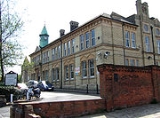
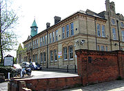
From the 1860s the residential area developed, grand Victorian houses were built along Anerley Road, and Anerley formed part of the Parish of St Paul's, forming in 1861. Anerley Vestry Hall (Anerley Town hall) was built in 1878 for the sum of £4,341, to conduct public business for the area. It become a Town hall as a result of the London Government Act 1899London Government Act 1899
The London Government Act 1899 was an Act of the Parliament of the United Kingdom that reformed the administration of the capital. The Act divided the County of London into 28 metropolitan boroughs, replacing the 41 parish vestries and District Boards of Works administering the area...
, thus in 1900 becoming part of the Penge Urban District
Penge Urban District
Penge was a civil parish and a local government district located to the southeast of London, England. It included the settlements of Penge, Anerley and part of Crystal Palace...
of Kent
Kent
Kent is a county in southeast England, and is one of the home counties. It borders East Sussex, Surrey and Greater London and has a defined boundary with Essex in the middle of the Thames Estuary. The ceremonial county boundaries of Kent include the shire county of Kent and the unitary borough of...
. The Hall was enlarged in 1911 for the sum of £3,229 and contained offices, a public hall, the council chamber, committee rooms, and a petty sessional court opened in 1925. By the beginning of the 20th Century, Anerley, like the now known area of Crystal Palace was in decline with much of the grand Victorian houses converted into flats, and by the middle of the century housing estates constructed. Anerley became part of the London Borough of Bromley
London Borough of Bromley
The London Borough of Bromley is a London borough of south east London, England and forms part of Outer London. The principal town in the borough is Bromley.-Geography:...
in 1965. With the demise of the local government ward of Anerley, the name Anerley is mainly applied to the area in the proximity of the railway station, to the top of Anerley Hill Road and down to the Birkbeck station
Birkbeck station
Birkbeck station is a railway station and light rail stop in the London Borough of Bromley in the southern suburbs of London. It is located on Elmers End Road and alongside Beckenham Crematorium.- Network rail :...
border divide with London and Kent
Kent
Kent is a county in southeast England, and is one of the home counties. It borders East Sussex, Surrey and Greater London and has a defined boundary with Essex in the middle of the Thames Estuary. The ceremonial county boundaries of Kent include the shire county of Kent and the unitary borough of...
. The postcode SE20 postcode district was officially named Anerley but covered Anerley, Penge and parts of Beckenham
Beckenham
Beckenham is a town in the London Borough of Bromley, England. It is located 8.4 miles south east of Charing Cross and 1.75 miles west of Bromley town...
. Anerley Bicycle Club founded in 1881 was one of the first UK cycle clubs. S.F.Edge was its most famous member and national champion. It met at the now demolished Robin Hood pub for rides into the Kent and Surrey countryside. However, as London expanded the the countryside receded it moved out and is now based in Purley in the London Borough of Croydon
London Borough of Croydon
The London Borough of Croydon is a London borough in South London, England and is part of Outer London. It covers an area of and is the largest London borough by population. It is the southernmost borough of London. At its centre is the historic town of Croydon from which the borough takes its name...
.
WWII
During World War IIWorld War II
World War II, or the Second World War , was a global conflict lasting from 1939 to 1945, involving most of the world's nations—including all of the great powers—eventually forming two opposing military alliances: the Allies and the Axis...
Anerley suffered extensive bomb damage, with 5 V1 Rockets
landing, a further 6 landed in Crystal Palace Park and a total of 23 in the whole SE20 district. On the 18th June 1944 it was reported a V1 Rocket was being chased by a Spitfire, and then shot down by AA gun fire. The shot down V1 fell upon Anerley Park near the junction of Anerley road. 2 People were killed and the damage to property were 3 houses destroyed with a further 20 houses severely damaged. On 11th July 1944 the third V1 Rocket strike to hit Anerley landed on Anerley Road at the Junction with Crystal Palace railway station. People had heard the rocket cut out and ran for cover, with many failing to find any, killing 11 People. The Shops on Station road were totally destroyed, on Anerley road 18 shops were demolished, 8 shops and 7 houses serverely damaged and 84 houses with minor damage. The Paxton Arms pub was also partially destroyed and would not re-open until 1955. The last rocket would strike Anerley the 24th August 1944.
Buses
Anerley is served by London busesLondon Buses
London Buses is the subsidiary of Transport for London that manages bus services within Greater London, UK. Buses are required to carry similar red colour schemes and conform to the same fare scheme...
routes N3
London Buses route 3
London Buses route 3 is a Transport for London contracted bus route in London, England, United Kingdom. The service is currently contracted to Abellio London.-History:...
, 75
London Buses route 75
London Buses route 75 is a Transport for London contracted bus route in London, United Kingdom. The service is currently contracted to Metrobus.-History:...
, 157
London Buses route 157
London Buses route 157 is a Transport for London contracted bus route in London, United Kingdom. The service is currently contracted to Abellio London.-History:...
, 197
London Buses route 197
London Buses route 197 is a Transport for London contracted bus route in London, United Kingdom. The service is currently contracted to Arriva London....
, 249, 354, 358 432 and bus 356. The 432 now terminates at Anerley Bus stand, behind the Station on Anerley Station Road.
Road
Two A roads, the A213A213 road
The A213 is an A road in South London. It runs from Sydenham to Broad Green. It crosses through 3 London Boroughs which includes the start in the London Borough of Lewisham, a small section in the London Borough of Bromley and the ending part inside the Croydon...
and A214
A214 road
The A214 is a part primary, part non-primary A road in London, England. It runs from Wandsworth to West Wickham. The section at Wandsworth, which is part of Trinity Road, was to be part of the London Ringways and is built as a three lane dual carriageway. The route runs through the London...
pass through the area. During the late 1960s and 1970s the A214 was to be part of the London Ringways
London Ringways
The London Ringways were a series of four ring roads planned in the 1960s to circle London at various distances from the city centre. They were part of a comprehensive scheme developed by the Greater London Council to alleviate traffic congestion on the city's road system by providing high speed...
project. The A214 was to become Ringway 2
Ringway 2
Ringway 2 was the second innermost of the series of four London Ringways, ring roads planned in the 1960s to circle London at various distances from the city centre...
and it would have passed through much of Anerley, and have followed the railway line from Birkbeck station
Birkbeck station
Birkbeck station is a railway station and light rail stop in the London Borough of Bromley in the southern suburbs of London. It is located on Elmers End Road and alongside Beckenham Crematorium.- Network rail :...
and travelled north. The construction of the A214 into the planned London Motorways network (much like the A2
A2 road (Great Britain)
The A2 is a major road in southern England, connecting London with the English Channel port of Dover in Kent. This route has always been of importance as a connection between the British capital of London and sea trade routes to Continental Europe...
or Hammersmith flyover London section today), would have seen a lot of destruction of property in Anerley and a great increase in noise pollution. After much consultation and Government dithering the various London Ringway projects were cancelled, including the A214 section.
Rail
- Anerley railway stationAnerley railway stationAnerley railway station is in the London Borough of Bromley in south London. The station is operated by London Overground, with London Overground and Southern trains serving the station. It is located in Travelcard Zone 4....
, SouthernSouthern (train operating company)Southern is a train operating company in the United Kingdom. Officially named Southern Railway Ltd., it is a subsidiary of Govia, a joint venture between transport groups Go-Ahead Group and Keolis, and has operated the South Central rail franchise since October 2000 and the Gatwick Express service...
operate trains to London BridgeLondon Bridge stationLondon Bridge railway station is a central London railway terminus and London Underground complex in the London Borough of Southwark, occupying a large area on two levels immediately south-east of London Bridge and 1.6 miles east of Charing Cross. It is one of the oldest railway stations in the...
and East CroydonEast Croydon stationEast Croydon station is a railway station and tram stop in Croydon, 10.35 miles south of London Bridge in Travelcard Zone 5. It is the largest and busiest station in Croydon and the busiest in London outside Travelcard Zone 1 in terms of the number of passengers entering and exiting...
or West CroydonWest Croydon stationWest Croydon station is a transport interchange for National Rail and Tramlink services, as well as London Buses. It is in the London Borough of Croydon and Travelcard Zone 5...
. London OvergroundLondon OvergroundLondon Overground is a suburban rail network in London and Hertfordshire. It has been operated by London Overground Rail Operations since 2007 as part of the National Rail network, under the franchise control and branding of Transport for London...
Also operate the East London Railway from Dalston JunctionDalston Junction railway stationDalston Junction railway station is in the Dalston area of the London Borough of Hackney at the crossroad of Dalston Lane, Kingsland Road and Balls Pond Road...
to West Croydon. - Birkbeck stationBirkbeck stationBirkbeck station is a railway station and light rail stop in the London Borough of Bromley in the southern suburbs of London. It is located on Elmers End Road and alongside Beckenham Crematorium.- Network rail :...
, SouthernSouthern (train operating company)Southern is a train operating company in the United Kingdom. Officially named Southern Railway Ltd., it is a subsidiary of Govia, a joint venture between transport groups Go-Ahead Group and Keolis, and has operated the South Central rail franchise since October 2000 and the Gatwick Express service...
also operate from Birkbeck to London Bridge and London Victoria (Mornings only).
Trams
- Birkbeck stationBirkbeck stationBirkbeck station is a railway station and light rail stop in the London Borough of Bromley in the southern suburbs of London. It is located on Elmers End Road and alongside Beckenham Crematorium.- Network rail :...
, TFLTransport for LondonTransport for London is the local government body responsible for most aspects of the transport system in Greater London in England. Its role is to implement the transport strategy and to manage transport services across London...
operate from Birkbeck to Beckenham Junction and CroydonEast Croydon stationEast Croydon station is a railway station and tram stop in Croydon, 10.35 miles south of London Bridge in Travelcard Zone 5. It is the largest and busiest station in Croydon and the busiest in London outside Travelcard Zone 1 in terms of the number of passengers entering and exiting...
.
In the era of street trams, a tramway ran down Anerley Road, turning into Croydon Road. It joined the main tram network at West Croydon
West Croydon station
West Croydon station is a transport interchange for National Rail and Tramlink services, as well as London Buses. It is in the London Borough of Croydon and Travelcard Zone 5...
. In the early days a stationary engine was needed to haul trams up the steepest part of Anerley Hill. Later models were able to climb unassisted, but special gearing was designed exclusively for this route. The tramway was replaced by trolley buses on route 654 which operated until 1959.
Transport for London had proposed the extension of Tramlink
Tramlink
Tramlink is a tramway system in south London in the United Kingdom which began operation in May 2000...
services from Harrington Road tram stop
Harrington Road tram stop
Harrington Road tram stop is a light rail stop in South Norwood in the London Borough of Croydon in the southern suburbs of London. Harrington Road is in a residential area, and along with Woodside tram stop is the nearest tram stop to the town of South Norwood...
to the bus station
Bus station
A bus station is a structure where city or intercity buses stop to pick up and drop off passengers. It is larger than a bus stop, which is usually simply a place on the roadside, where buses can stop...
on Crystal Palace Parade via Anerley Road and a consultation exercise finished in December 2006. However Mayor Boris Johnson
Boris Johnson
Alexander Boris de Pfeffel Johnson is a British journalist and Conservative Party politician, who has been the elected Mayor of London since 2008...
cancelled the 170 million pound extension in November 2008.
Notable residents
- Thomas CrapperThomas CrapperThomas Crapper was a plumber who founded Thomas Crapper & Co. in London. Contrary to widespread misconceptions, Crapper did not invent the flush toilet. He did, however, do much to increase the popularity of the toilet, and developed some important related inventions, such as the ballcock...
, notable plumber (who did not invent the toilet, but promoted it), on his retirement lived at 12 Thornsett Road. - Walter de la MareWalter de la MareWalter John de la Mare , OM CH was an English poet, short story writer and novelist, probably best remembered for his works for children and the poem "The Listeners"....
, famous poet and author of ghost stories, resided at 14 Thornsett Road during the 1920s. - James BusbyJames BusbyJames Busby is widely regarded as the "father" of the Australian wine industry, as he took the first collection of vine stock from Spain and France to Australia. Later he become a British Resident who traveled to New Zealand, involved in the drafting of the Declaration of the Independence of New...
, authored the Treaty of WaitangiTreaty of WaitangiThe Treaty of Waitangi is a treaty first signed on 6 February 1840 by representatives of the British Crown and various Māori chiefs from the North Island of New Zealand....
and introduced vines to Australia - Arthur BigsworthArthur BigsworthAir Commodore Arthur Wellesley Bigsworth CMG,DSO and bar, AFC, was a pioneer aviator who had a distinguished military career in the service of the British armed forces.-Early life:...
, aviator was born in Anerley in 1885, said to be the inspiration for W. E. JohnsW. E. JohnsWilliam Earl Johns was an English pilot and writer of adventure stories, usually written under the name Captain W. E. Johns. He is best remembered as the creator of the ace pilot and adventurer Biggles.-Early life:...
fictional hero BigglesBiggles"Biggles" , a pilot and adventurer, is the title character and main hero of the Biggles series of youth-oriented adventure books written by W. E. Johns....
.
Nearest places
- BeckenhamBeckenhamBeckenham is a town in the London Borough of Bromley, England. It is located 8.4 miles south east of Charing Cross and 1.75 miles west of Bromley town...
- PengePengePenge is a suburb of London in the London Borough of Bromley. It is located south east of Charing Cross.-History:Penge was once a small town, which was recorded under the name Penceat in a Saxon deed dating from 957...
- South NorwoodSouth NorwoodSouth Norwood is an urban town and in south London, England, in the London Borough of Croydon. It is a suburban development 7.8 miles south-east of Charing Cross. South Norwood is an electoral with a resident population in 2001 of just over 14,000...
- SydenhamSydenhamSydenham is an area and electoral ward in the London Borough of Lewisham; although some streets towards Crystal Palace Park, Forest Hill and Penge are outside the ward and in the London Borough of Bromley, and some streets off Sydenham Hill are in the London Borough of Southwark. Sydenham was in...
- Upper NorwoodUpper NorwoodUpper Norwood is an elevated area in south London, England within the postcode SE19. It is a residential district largely in the London Borough of Croydon although some parts extend into the London Borough of Lambeth, London Borough of Southwark and the London Borough of Bromley. Upper Norwood...