
Bourbon County, Kansas
Encyclopedia
Bourbon County is a county located in Southeast
Kansas
, in the Central
United States
. As of the 2010 census, the county population was 15,173. Its county seat
and most populous city is Fort Scott
.
, county until 1992, when voters approved the sale of alcoholic liquor by the individual drink with a 30% food sales requirement.
 As of the U.S. Census in 2000
, there were 15,379 people, 6,161 households, and 4,127 families residing in the county. The population density
was 24 people per square mile (9/km²). There were 7,135 housing units at an average density of 11 per square mile (4/km²). The racial makeup
of the county was 94.06% White
, 3.08% Black or African American
, 0.84% Native American
, 0.36% Asian
, 0.05% Pacific Islander
, 0.28% from other races, and 1.33% from two or more races
. Hispanic
or Latino
of any race were 1.29% of the population.
There were 6,161 household
s out of which 30.50% had children under the age of 18 living with them, 54.50% were married couples
living together, 9.20% had a female householder with no husband present, and 33.00% were non-families. 29.00% of all households were made up of individuals and 14.90% had someone living alone who was 65 years of age or older. The average household size was 2.44 and the average family size was 3.01.
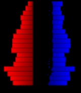
In the county the population was spread out with 25.80% under the age of 18, 9.50% from 18 to 24, 24.20% from 25 to 44, 22.30% from 45 to 64, and 18.20% who were 65 years of age or older. The median age was 38 years. For every 100 females there were 93.00 males. For every 100 females age 18 and over, there were 88.50 males.
The median income for a household
in the county was $31,199, and the median income for a family was $39,239. Males had a median income of $27,043 versus $20,983 for females. The per capita income
for the county was $16,393. About 9.50% of families and 13.50% of the population were below the poverty line, including 18.00% of those under age 18 and 13.40% of those age 65 or over.
. The city of Fort Scott
is considered governmentally independent and is excluded from the census figures for the townships. In the following table, the population center is the largest city (or cities) included in that township's population total, if it is of a significant size.
Maps
Southeast Kansas
Southeast Kansas is a region of the U.S. state of Kansas. It can be roughly defined by Woodson County in the northwest, Bourbon County in the northeast, Cherokee County in the southeast, and Montgomery County in the southwest. Geographically it is dominated by a broad rolling landscape located...
Kansas
Kansas
Kansas is a US state located in the Midwestern United States. It is named after the Kansas River which flows through it, which in turn was named after the Kansa Native American tribe, which inhabited the area. The tribe's name is often said to mean "people of the wind" or "people of the south...
, in the Central
Central United States
The Central United States is sometimes conceived as between the Eastern United States and Western United States as part of a three-region model, roughly coincident with the Midwestern United States plus the western and central portions of the Southern United States; the term is also sometimes used...
United States
United States
The United States of America is a federal constitutional republic comprising fifty states and a federal district...
. As of the 2010 census, the county population was 15,173. Its county seat
County seat
A county seat is an administrative center, or seat of government, for a county or civil parish. The term is primarily used in the United States....
and most populous city is Fort Scott
Fort Scott, Kansas
Fort Scott is a city in and the county seat of Bourbon County, Kansas, United States, south of Kansas City, on the Marmaton River. As of the 2010 census, the city population was 8,087. It is the home of the Fort Scott National Historic Site and the Fort Scott National...
.
Law and government
Following amendment to the Kansas Constitution in 1986, the county remained a prohibition, or "dry"Dry county
A dry county is a county in the United States whose government forbids the sale of alcoholic beverages. Some prohibit off-premises sale, some prohibit on-premises sale, and some prohibit both. Hundreds of dry counties exist across the United States, almost all of them in the South...
, county until 1992, when voters approved the sale of alcoholic liquor by the individual drink with a 30% food sales requirement.
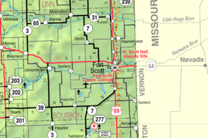
Geography
According to the 2000 census, the county has a total area of 638.82 square miles (1,654.5 km²), of which 637.09 square miles (1,650.1 km²) (or 99.73%) is land and 1.73 square miles (4.5 km²) (or 0.27%) is water.Adjacent counties
- Linn CountyLinn County, KansasLinn County is a county located in East Central Kansas, in the Central United States. As of the 2010 census, the county population was 9,656. Its county seat is Mound City, and its most populous city is Pleasanton...
(north) - Vernon County, MissouriMissouriMissouri is a US state located in the Midwestern United States, bordered by Iowa, Illinois, Kentucky, Tennessee, Arkansas, Oklahoma, Kansas and Nebraska. With a 2010 population of 5,988,927, Missouri is the 18th most populous state in the nation and the fifth most populous in the Midwest. It...
(east) - Crawford CountyCrawford County, KansasCrawford County is a county located in southeastern Kansas in the United States. As of the 2010 census, the county population was 39,134. Its county seat is Girard, and its most populous city is Pittsburg. The county was named in honor of Samuel J. Crawford, Governor of Kansas...
(south) - Neosho CountyNeosho County, KansasNeosho County is a county located in the U.S. state of Kansas. As of the 2010 census, the county population was 16,512...
(southwest) - Allen CountyAllen County, KansasAllen County is a county located in southeast Kansas, in the central United States of America. As of the 2010 census, the county population was 13,371...
(west) - Anderson CountyAnderson County, KansasAnderson County is a county located in East Central Kansas, in the Central United States. As of the 2010 census, the county population was 8,102...
(northwest)
Major highways
Sources: National Atlas, U.S. Census Bureau- U.S. Route 54U.S. Route 54U.S. Route 54 is an east–west United States highway that runs northeast-southwest for 1,197 miles from western Illinois to El Paso, Texas. It enters and leaves Texas twice...
- U.S. Route 69U.S. Route 69U.S. Route 69 is a north–south United States highway. When it was first created, it was only long, but it has since been expanded into a Minnesota to Texas cross-country route. The highway's southern terminus is in Port Arthur, Texas at an intersection with State Highway 87...
- Kansas Highway 3K-3 (Kansas highway)K-3 is a state highway in the U.S. state of Kansas. It runs through Crawford, Bourbon and Linn Counties in southeastern Kansas.-Route description:...
- Kansas Highway 7K-7 (Kansas highway)K-7 is a state highway in the U.S. state of Kansas. It is mostly a small country highway winding its way through the Osage Questas and Glaciated Regions of eastern Kansas, although a portion of the highway passes through the Kansas City metropolitan area. Significant portions of the highway overlap...
- Kansas Highway 31
- Kansas Highway 39
- Kansas Highway 65
Demographics
United States Census, 2000
The Twenty-second United States Census, known as Census 2000 and conducted by the Census Bureau, determined the resident population of the United States on April 1, 2000, to be 281,421,906, an increase of 13.2% over the 248,709,873 persons enumerated during the 1990 Census...
, there were 15,379 people, 6,161 households, and 4,127 families residing in the county. The population density
Population density
Population density is a measurement of population per unit area or unit volume. It is frequently applied to living organisms, and particularly to humans...
was 24 people per square mile (9/km²). There were 7,135 housing units at an average density of 11 per square mile (4/km²). The racial makeup
Race (United States Census)
Race and ethnicity in the United States Census, as defined by the Federal Office of Management and Budget and the United States Census Bureau, are self-identification data items in which residents choose the race or races with which they most closely identify, and indicate whether or not they are...
of the county was 94.06% White
White American
White Americans are people of the United States who are considered or consider themselves White. The United States Census Bureau defines White people as those "having origins in any of the original peoples of Europe, the Middle East, or North Africa...
, 3.08% Black or African American
African American
African Americans are citizens or residents of the United States who have at least partial ancestry from any of the native populations of Sub-Saharan Africa and are the direct descendants of enslaved Africans within the boundaries of the present United States...
, 0.84% Native American
Native Americans in the United States
Native Americans in the United States are the indigenous peoples in North America within the boundaries of the present-day continental United States, parts of Alaska, and the island state of Hawaii. They are composed of numerous, distinct tribes, states, and ethnic groups, many of which survive as...
, 0.36% Asian
Asian American
Asian Americans are Americans of Asian descent. The U.S. Census Bureau definition of Asians as "Asian” refers to a person having origins in any of the original peoples of the Far East, Southeast Asia, or the Indian subcontinent, including, for example, Cambodia, China, India, Indonesia, Japan,...
, 0.05% Pacific Islander
Pacific Islander American
Pacific Islander Americans, also known as Oceanian Americans, are residents of the United States with original ancestry from Oceania. They represent the smallest racial group counted in the United States census of 2000. They numbered 874,000 people or 0.3 percent of the United States population...
, 0.28% from other races, and 1.33% from two or more races
Multiracial
The terms multiracial and mixed-race describe people whose ancestries come from multiple races. Unlike the term biracial, which often is only used to refer to having parents or grandparents of two different races, the term multiracial may encompass biracial people but can also include people with...
. Hispanic
Hispanic
Hispanic is a term that originally denoted a relationship to Hispania, which is to say the Iberian Peninsula: Andorra, Gibraltar, Portugal and Spain. During the Modern Era, Hispanic sometimes takes on a more limited meaning, particularly in the United States, where the term means a person of ...
or Latino
Latino
The demonyms Latino and Latina , are defined in English language dictionaries as:* "a person of Latin-American descent."* "A Latin American."* "A person of Hispanic, especially Latin-American, descent, often one living in the United States."...
of any race were 1.29% of the population.
There were 6,161 household
Household
The household is "the basic residential unit in which economic production, consumption, inheritance, child rearing, and shelter are organized and carried out"; [the household] "may or may not be synonymous with family"....
s out of which 30.50% had children under the age of 18 living with them, 54.50% were married couples
Marriage
Marriage is a social union or legal contract between people that creates kinship. It is an institution in which interpersonal relationships, usually intimate and sexual, are acknowledged in a variety of ways, depending on the culture or subculture in which it is found...
living together, 9.20% had a female householder with no husband present, and 33.00% were non-families. 29.00% of all households were made up of individuals and 14.90% had someone living alone who was 65 years of age or older. The average household size was 2.44 and the average family size was 3.01.
In the county the population was spread out with 25.80% under the age of 18, 9.50% from 18 to 24, 24.20% from 25 to 44, 22.30% from 45 to 64, and 18.20% who were 65 years of age or older. The median age was 38 years. For every 100 females there were 93.00 males. For every 100 females age 18 and over, there were 88.50 males.
The median income for a household
Median household income
The median household income is commonly used to generate data about geographic areas and divides households into two equal segments with the first half of households earning less than the median household income and the other half earning more...
in the county was $31,199, and the median income for a family was $39,239. Males had a median income of $27,043 versus $20,983 for females. The per capita income
Per capita income
Per capita income or income per person is a measure of mean income within an economic aggregate, such as a country or city. It is calculated by taking a measure of all sources of income in the aggregate and dividing it by the total population...
for the county was $16,393. About 9.50% of families and 13.50% of the population were below the poverty line, including 18.00% of those under age 18 and 13.40% of those age 65 or over.
Incorporated cities
Name and population ( estimate):- Fort ScottFort Scott, KansasFort Scott is a city in and the county seat of Bourbon County, Kansas, United States, south of Kansas City, on the Marmaton River. As of the 2010 census, the city population was 8,087. It is the home of the Fort Scott National Historic Site and the Fort Scott National...
, (county seat) - BronsonBronson, KansasBronson is a city in Bourbon County, Kansas, United States. The population was 346 at the 2000 census. The community was named after Ira Bronson, a railroad official.-Geography:Bronson is located at ....
, - UniontownUniontown, KansasUniontown is a city in Bourbon County, Kansas, United States. As of the 2010 census, the city population was 272.-Geography:Uniontown is located at , along the Marmaton River...
, - FultonFulton, KansasFulton is a city in Bourbon County, Kansas, United States. The population was 184 at the 2000 census.-History:During the American Civil War, Fort Lincoln was built and operated near Fulton as part of the Fort Scott defense, mostly as a prisoner-of-war camp...
, - RedfieldRedfield, KansasRedfield is a city in Bourbon County, Kansas, United States. The population was 140 at the 2000 census.-Geography:Redfield is located at , along the Marmaton River....
, - MapletonMapleton, KansasMapleton is a city in Bourbon County, Kansas, United States. The population was 98 at the 2000 census.-Geography:Mapleton is located at . According to the United States Census Bureau, the city has a total area of , all of it land....
,
Unincorporated places
- Barnesville
- Berlin
- Devon
- Garland
- Godfrey
- Hammond
- Harding
- Hiattville
- Hidden Valley
- Hollister (no longer exists)
- Marmaton
- Pawnee Station (a/k/a Anna)
- Ronald (Walkertown)
- XeniaXenia, KansasXenia is a small unincorporated community in Franklin Township, Bourbon County, Kansas, United States. Located at an altitude of 1,040 feet , it lies along K-65 west of the confluence of the Little Osage River and Limestone Creek.It is the home of Xenia Masonic Lodge 47, which meets the first...
Townships
Bourbon County is divided into eleven townshipsCivil township
A civil township is a widely used unit of local government in the United States, subordinate to, and geographic divisions of, a county. Specific responsibilities and the degree of autonomy vary based on each state. Civil townships are distinct from survey townships, but in states that have both,...
. The city of Fort Scott
Fort Scott, Kansas
Fort Scott is a city in and the county seat of Bourbon County, Kansas, United States, south of Kansas City, on the Marmaton River. As of the 2010 census, the city population was 8,087. It is the home of the Fort Scott National Historic Site and the Fort Scott National...
is considered governmentally independent and is excluded from the census figures for the townships. In the following table, the population center is the largest city (or cities) included in that township's population total, if it is of a significant size.
| Township | FIPS | Population center |
Population | Population density /km² (/sq mi) |
Land area km² (sq mi) | Water area km² (sq mi) | Water % | Geographic coordinates |
|---|---|---|---|---|---|---|---|---|
| Drywood | 18750 | 394 | 3 (8) | 120 (47) | 0 (0) | 0.19% | 37°43′19"N 94°40′36"W | |
| Franklin | 24300 | 312 | 2 (4) | 185 (71) | 0 (0) | 0.13% | 37°59′41"N 94°59′14"W | |
| Freedom | 24600 | Fulton Fulton, Kansas Fulton is a city in Bourbon County, Kansas, United States. The population was 184 at the 2000 census.-History:During the American Civil War, Fort Lincoln was built and operated near Fulton as part of the Fort Scott defense, mostly as a prisoner-of-war camp... |
505 | 4 (12) | 113 (44) | 0 (0) | 0.17% | 38°0′4"N 94°44′45"W |
| Marion | 44650 | Bronson Bronson, Kansas Bronson is a city in Bourbon County, Kansas, United States. The population was 346 at the 2000 census. The community was named after Ira Bronson, a railroad official.-Geography:Bronson is located at .... , Uniontown Uniontown, Kansas Uniontown is a city in Bourbon County, Kansas, United States. As of the 2010 census, the city population was 272.-Geography:Uniontown is located at , along the Marmaton River... |
1,165 | 4 (12) | 259 (100) | 0 (0) | 0.19% | 37°51′14"N 95°1′12"W |
| Marmaton | 44900 | 815 | 6 (15) | 145 (56) | 0 (0) | 0.13% | 37°48′57"N 94°50′16"W | |
| Mill Creek | 46675 | 472 | 3 (9) | 136 (52) | 1 (0) | 0.42% | 37°54′45"N 94°50′14"W | |
| Osage | 53100 | 394 | 3 (8) | 125 (48) | 0 (0) | 0.16% | 37°58′40"N 94°39′33"W | |
| Pawnee | 54775 | 308 | 2 (6) | 126 (49) | 0 (0) | 0.31% | 37°43′31"N 94°50′30"W | |
| Scott | 63500 | 2,326 | 13 (34) | 179 (69) | 2 (1) | 0.94% | 37°48′35"N 94°41′30"W | |
| Timberhill | 70600 | Mapleton Mapleton, Kansas Mapleton is a city in Bourbon County, Kansas, United States. The population was 98 at the 2000 census.-Geography:Mapleton is located at . According to the United States Census Bureau, the city has a total area of , all of it land.... |
256 | 3 (7) | 93 (36) | 0 (0) | 0.05% | 38°0′31"N 94°52′57"W |
| Walnut | 74850 | 135 | 1 (2) | 154 (59) | 0 (0) | 0.13% | 37°43′10"N 94°59′0"W | |
| Sources: | ||||||||
See also
- National Register of Historic Places listings in Bourbon County, KansasNational Register of Historic Places listings in Bourbon County, KansasThis is a list of the National Register of Historic Places listings in Bourbon County, Kansas.This is intended to be a complete list of the properties and districts on the National Register of Historic Places in Bourbon County, Kansas, United States...
Further reading
- History of the State of Kansas; William G. Cutler; A.T. Andreas Publisher; 1883. (Online HTML eBook)
- Kansas : A Cyclopedia of State History, Embracing Events, Institutions, Industries, Counties, Cities, Towns, Prominent Persons, Etc; 3 Volumes; Frank W. Blackmar; Standard Publishing Co; 944 / 955 / 824 pages; 1912. (Volume1 - Download 54MB PDF eBook),(Volume2 - Download 53MB PDF eBook), (Volume3 - Download 33MB PDF eBook)
External links
County- Bourbon County - Official Website
- Bourbon County - Directory of Public Officials
- Bourbon County - Information, Skyways
Maps
- Bourbon County Map, KDOT
- Kansas Highway Map, KDOT
- Kansas Railroad Map, KDOT
- Kansas School District Boundary Map, KSDE