

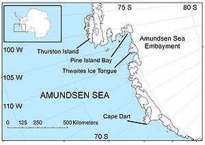
Amundsen Sea
Encyclopedia
Southern Ocean
The Southern Ocean comprises the southernmost waters of the World Ocean, generally taken to be south of 60°S latitude and encircling Antarctica. It is usually regarded as the fourth-largest of the five principal oceanic divisions...
off Marie Byrd Land
Marie Byrd Land
Marie Byrd Land is the portion of West Antarctica lying east of the Ross Ice Shelf and the Ross Sea and south of the Pacific Ocean, extending eastward approximately to a line between the head of the Ross Ice Shelf and Eights Coast. It stretches between 158°W and 103°24'W...
in western Antarctica. It is bounded by Cape Flying Fish
Cape Flying Fish
Cape Flying Fish is an ice-covered cape which forms the west extremity of Thurston Island. It was discovered by Rear Admiral Byrd and members of the US Antarctic Service in a flight from the Bear in February 1940. Named by US-SCAN for the United States Exploring Expedition ship Flying Fish,...
, the northwestern tip of Thurston Island
Thurston Island
Thurston Island is an ice-covered, glacially dissected island, long, wide and in area, lying a short way off the NW end of Ellsworth Land, Antarctica. It is the third largest island of Antarctica, after Alexander Island and Berkner Island...
to the east and Cape Dart
Cape Dart
Cape Dart is a cape at the foot of Mount Siple on the north coast of Siple Island, just southward of Lauff Island off Bakutis Coast, Marie Byrd Land. It was discovered in December 1940 by members of the United States Antarctic Service in a flight from West Base. It is named for Justin Whitlock...
on Siple Island
Siple Island
Siple Island is a long snow-covered island lying east of Wrigley Gulf along the Getz Ice Shelf off Bakutis Coast of Marie Byrd Land, Antarctica...
to the west. East of Cape Flying Fish starts the Bellingshausen Sea
Bellingshausen Sea
The Bellingshausen Sea is an area along the west side of the Antarctic Peninsula, west of Alexander Island, east of Cape Flying Fish on Thurston Island, and south of Peter I Island . In the south are, from west to east, Eights Coast, Bryan Coast and English Coast of West Antarctica...
. West of Cape Dart is no named marginal sea
Marginal sea
The term marginal sea has differing meanings. In one sense the term is equivalent to territorial waters. In another sense the term indicates a partially enclosed sea adjacent to or widely open to the open ocean, but bounded by submarine ridges...
of the Southern Ocean
Southern Ocean
The Southern Ocean comprises the southernmost waters of the World Ocean, generally taken to be south of 60°S latitude and encircling Antarctica. It is usually regarded as the fourth-largest of the five principal oceanic divisions...
between Amundsen Sea and Ross Sea
Ross Sea
The Ross Sea is a deep bay of the Southern Ocean in Antarctica between Victoria Land and Marie Byrd Land.-Description:The Ross Sea was discovered by James Ross in 1841. In the west of the Ross Sea is Ross Island with the Mt. Erebus volcano, in the east Roosevelt Island. The southern part is covered...
. Named for the Norwegian polar explorer Roald Amundsen
Roald Amundsen
Roald Engelbregt Gravning Amundsen was a Norwegian explorer of polar regions. He led the first Antarctic expedition to reach the South Pole between 1910 and 1912 and he was the first person to reach both the North and South Poles. He is also known as the first to traverse the Northwest Passage....
by the Norwegian expedition of 1928–29, under Captain Nils Larsen, while exploring this area in February, 1929.
The sea is mostly ice-covered, and the Thwaites Ice Tongue protrudes into it. The ice sheet
Ice sheet
An ice sheet is a mass of glacier ice that covers surrounding terrain and is greater than 50,000 km² , thus also known as continental glacier...
which drains into the Amundsen Sea averages about 3 km (1.9 mi) in thickness; is roughly the size of the state of Texas and the area is known as the Amundsen Sea Embayment (ASE); it forms one of the three major ice drainage basins of the West Antarctic Ice Sheet
West Antarctic Ice Sheet
The West Antarctic Ice Sheet is the segment of the continental ice sheet that covers West Antarctica, the portion of Antarctica on the side of the Transantarctic Mountains which lies in the Western Hemisphere. The WAIS is classified as a marine-based ice sheet, meaning that its bed lies well...
.
Amundsen Sea Embayment
West Antarctic Ice Sheet
The West Antarctic Ice Sheet is the segment of the continental ice sheet that covers West Antarctica, the portion of Antarctica on the side of the Transantarctic Mountains which lies in the Western Hemisphere. The WAIS is classified as a marine-based ice sheet, meaning that its bed lies well...
, the others being the Ross Sea
Ross Sea
The Ross Sea is a deep bay of the Southern Ocean in Antarctica between Victoria Land and Marie Byrd Land.-Description:The Ross Sea was discovered by James Ross in 1841. In the west of the Ross Sea is Ross Island with the Mt. Erebus volcano, in the east Roosevelt Island. The southern part is covered...
Embayment and the Weddell Sea
Weddell Sea
The Weddell Sea is part of the Southern Ocean and contains the Weddell Gyre. Its land boundaries are defined by the bay formed from the coasts of Coats Land and the Antarctic Peninsula. The easternmost point is Cape Norvegia at Princess Martha Coast, Queen Maud Land. To the east of Cape Norvegia is...
Embayment. In March 2007, scientists studying the ASE through satellite and airborne surveys announced a significant thinning of the ASE, due to shifts in wind patterns that allow warmer waters to flow beneath the ice sheet.
Some scientists have proposed that this region may be a "weak underbelly" of the West Antarctic Ice Sheet
West Antarctic Ice Sheet
The West Antarctic Ice Sheet is the segment of the continental ice sheet that covers West Antarctica, the portion of Antarctica on the side of the Transantarctic Mountains which lies in the Western Hemisphere. The WAIS is classified as a marine-based ice sheet, meaning that its bed lies well...
. The Pine Island
Pine Island Glacier
- Ice sheet drainage :The Antarctic ice sheet is the largest mass of ice on earth, containing a volume of water equivalent to of global sea level. The ice sheet forms from snow which falls onto the continent and compacts under its own weight. The ice then moves under its own weight toward the...
and Thwaites
Thwaites Glacier
Thwaites Glacier is an unusually broad and fast Antarctic glacier flowing into Pine Island Bay, part of the Amundsen Sea, east of Mount Murphy, on the Walgreen Coast of Marie Byrd Land. Its surface speeds exceed 2 km/yr near its grounding line, and its fastest flowing grounded ice is centred...
Glaciers, which both flow into the Amundsen Sea, are two of Antarctica's largest five. Scientists have found that the flow of these glaciers has increased in recent years, if they were to melt completely global sea levels would rise
Current sea level rise
Current sea level rise potentially impacts human populations and the wider natural environment . Global average sea level rose at an average rate of around 1.8 mm per year over 1961 to 2003 and at an average rate of about 3.1 mm per year from 1993 to 2003...
by about 0.9–1.9 m (1–2 yards). Scientist have suggested that the loss of these glaciers would destabilise the entire West Antarctic ice sheet and possibly sections of the East Antarctic Ice Sheet
East Antarctic Ice Sheet
The East Antarctic Ice Sheet is one of two large ice sheets in Antarctica, and the largest on the entire planet. The EAIS lies between 45° West and 168° East longitudinally....
.
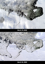
A study in October 2004 suggested that because the ice in the Amundsen Sea had been melting rapidly and became riveted with cracks, the offshore ice shelf was set to collapse "within five years". The study projected a sea level rise of 1.3 m (4.3 ft) from the West Antarctic Ice Sheet if all the sea ice in the Amundsen Sea melted.
Measurements made by the British Antarctic Survey
British Antarctic Survey
The British Antarctic Survey is the United Kingdom's national Antarctic operation and has an active role in Antarctic affairs. BAS is part of the Natural Environment Research Council and has over 400 staff. It operates five research stations, two ships and five aircraft in and around Antarctica....
in 2005 showed that the ice discharge rate into the Amundsen Sea embayment was about 250 km3 per year. Assuming a steady rate of discharge, this alone is sufficient to raise global sea levels by 0.2 mm per year.
A subglacial volcano
Volcano
2. Bedrock3. Conduit 4. Base5. Sill6. Dike7. Layers of ash emitted by the volcano8. Flank| 9. Layers of lava emitted by the volcano10. Throat11. Parasitic cone12. Lava flow13. Vent14. Crater15...
has also been detected in the area, just west of the Pine Island Glacier near the Hudson Mountains
Hudson Mountains
The Hudson Mountains is a group of parasitic cones forming nunataks just above the Antarctic ice sheet in west Ellsworth Land. They lie just east of Cranton Bay and Pine Island Bay at the eastern extremity of Amundsen Sea, and are bounded on the north by Cosgrove Ice Shelf and on the south by Pine...
. It last erupted approximately 2,200 years ago, indicated by widespread ash
Volcanic ash
Volcanic ash consists of small tephra, which are bits of pulverized rock and glass created by volcanic eruptions, less than in diameter. There are three mechanisms of volcanic ash formation: gas release under decompression causing magmatic eruptions; thermal contraction from chilling on contact...
deposits within the ice, in what was the largest known eruption in Antarctica within the past 10 millennia. Volcanic activity in the region may be contributing to the observed increase of glacial flow, although currently the most popular theory amongst the scientists studying this area is that the flow has increased due to warming ocean water. This water has warmed due to an upwelling of deep ocean water which is due to variations in pressure systems, which could have been affected by global warming
Global warming
Global warming refers to the rising average temperature of Earth's atmosphere and oceans and its projected continuation. In the last 100 years, Earth's average surface temperature increased by about with about two thirds of the increase occurring over just the last three decades...
.
In January 2010, a modelling study suggested that the "tipping point" for Pine Island Glacier may have been passed in 1996, with a retreat of 200 km possible by 2100, producing a corresponding 24 cm (0.78740157480315 ft) of sea level rise, although it was suggested that these estimates for timespan were conservative. However, the modelling study also states that "Given the complex, three-dimensional nature of the real Pine Island glacier ... it should be clear that the [...] model is a very crude representation of reality."
Pine Island Bay
Pine Island Bay (74°50′S 102°40′W) is a bay about 40 miles (64.4 km) long and 30 miles (48.3 km) wide, into which flows the ice of the Pine Island GlacierPine Island Glacier
- Ice sheet drainage :The Antarctic ice sheet is the largest mass of ice on earth, containing a volume of water equivalent to of global sea level. The ice sheet forms from snow which falls onto the continent and compacts under its own weight. The ice then moves under its own weight toward the...
at the southeast extremity of the Amundsen Sea. It was delineated from aerial photographs taken by USN Operation Highjump
Operation Highjump
Operation Highjump , officially titled The United States Navy Antarctic Developments Program, 1946-1947, was a United States Navy operation organized by RADM Richard E. Byrd Jr. USN, , Officer in Charge, Task Force 68, and led by RADM Richard H. Cruzen, USN, Commanding Officer, Task Force 68....
in December 1946, and named by the Advisory Committee on Antarctic Names
Advisory Committee on Antarctic Names
The Advisory Committee on Antarctic Names is an advisory committee of the United States Board on Geographic Names responsible for recommending names for features in Antarctica...
(US-ACAN) for the USS Pine Island
USS Pine Island (AV-12)
USS Pine Island , a Currituck-class seaplane tender, is the only ship of the United States Navy to hold this name. The ship was named after Pine Island Sound ....
, seaplane tender and flagship of the eastern task group of USN Operation Highjump which explored this area.
Russell Bay
Russell Bay (73°27′S 123°54′W) is a rather open bay in southwestern Amundsen Sea, extending along the north sides of Siple IslandSiple Island
Siple Island is a long snow-covered island lying east of Wrigley Gulf along the Getz Ice Shelf off Bakutis Coast of Marie Byrd Land, Antarctica...
, Getz Ice Shelf
Getz Ice Shelf
Getz Ice Shelf is an Antarctic ice shelf, over 480 km long and from 32 to 96 km wide, bordering the Hobbs and Bakutis Coasts of Marie Byrd Land between McDonald Heights and Martin Peninsula. Several large islands are partially or wholly embedded in the ice shelf.The ice shelf westward of Siple...
and Carney Island
Carney Island
Carney Island is an ice-covered island, long and about in area, with all but its North coast lying within the Getz Ice Shelf, Antarctica. It is located between Siple Island and Wright Island along the coast ofMarie Byrd Land....
, from Pranke Island
Pranke Island
Pranke Island is a small ice-covered island lying close to Siple Island in the west extremity of Russell Bay, off the coast of Marie Byrd Land. Mapped by United States Geological Survey from ground surveys and U.S. Navy air photos, 1959-65. Named by Advisory Committee on Antarctic Names for...
to Cape Gates
Cape Gates
Cape Gates is an ice-covered cape which marks the northwest extremity of Carney Island along the coast of Marie Byrd Land. First mapped by United States Geological Survey from aerial photographs taken by U.S. Navy Operation Highjump in January 1947. Named by Advisory Committee on Antarctic Names ...
. It was mapped by United States Geological Survey
United States Geological Survey
The United States Geological Survey is a scientific agency of the United States government. The scientists of the USGS study the landscape of the United States, its natural resources, and the natural hazards that threaten it. The organization has four major science disciplines, concerning biology,...
(USGS) from surveys and U.S. Navy air photos, 1959–66, and named by the Advisory Committee on Antarctic Names
Advisory Committee on Antarctic Names
The Advisory Committee on Antarctic Names is an advisory committee of the United States Board on Geographic Names responsible for recommending names for features in Antarctica...
(US-ACAN) for Admiral James S. Russell, USN, Vice Chief of Naval Operations
Vice Chief of Naval Operations
The Vice Chief of Naval Operations is the second highest ranking officer in the United States Navy. In the event that the Chief of Naval Operations is absent or is unable to perform his duties, the VCNO assumes the duties and responsibilities of the CNO. The VCNO may also perform other duties...
during the post 1957–58 IGY period.