
Amphoe Umphang
Encyclopedia
Umphang is the southernmost district (amphoe
) of Tak Province
, Thailand
at the Thai-Myanmar
border. It is also the name of the town center of the district.
Neighboring districts are (North from clockwise): Amphoe Phop Phra
; Amphoe Khlong Lan
and Amphoe Pang Sila Thong
of Kamphaeng Phet Province
; Amphoe Mae Wong
and King Amphoe Mae Poen
of Nakhon Sawan Province
; Amphoe Ban Rai
of Uthai Thani Province
; and Amphoe Thong Pha Phum
and Amphoe Sangkhla Buri
of Kanchanaburi Province
. The western edge of the district has a long boundary with Burma (Myanmar
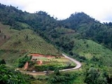
). Surrounded by national parks and wildlife reserves, it is one of the least accessible district in Thailand. Nevertheless, it has one major tourist attraction, Thi Lo Su Waterfall (น้ำตกทีลอซู), the largest waterfall of Thailand.
status.
while the central part near Umphang town is Umphang Wildlife Sanctuary. Directly east of Umphang Wildlife Sanctuary is Mae Wong National Park
(in Tak and Kamphaeng Phet Province) and Khlong Lan National Park
(in Kamphaeng Phet Province). The area, due to its difficulty of access, were used as a base of Communist Party of Thailand
.
An important river in Umphang is Klong River
(แม่น้ำกลอง) which originates here and flows southward into Kanchanaburi Province
.
making up the largest proportion. As Karens were the original settlers here before Thais began to migrate into the area, many place names are in Karen language.
 The Highway 1090 (Mae Sot
-Umphang) is the only road linking Umphang to other parts of Thailand. Another highway, Highway 1167, connect Umphang town to the Burmese border. Highway 1090, 164 km in total, has two lanes during much of the way and contains 1,219 curves, a number proudly displayed at numerous places in Umphang. It is one of the toughest roads for those who suffer from motion sickness
. The journey through this highway takes about 3 to 4 hours.
There was a Highway 1117 (Khlong Lan
-Umphang) project that would have provided a connection from Amphoe Khlong Lan
, Kamphaeng Phet Province
but the project was shelved in 1987 pending an environmental study. About 115 km of the highway beginning from Khlong Lan was already constructed, leaving the last 28 km on the Umphang side where it stopped in Umphang Wildlife Sanctuary in 1990. Suggestion to finish this project surfaced a few time but was eventually rejected due to the virgin forest the last 28 km section must cut through. Another project linking Umphang to Amphoe Sangkhla Buri
, Kanchanaburi Province
was proposed in 2004 but was immediately rejected.
Beside the highway 1090, there is a municipal airport in Umphang.
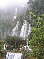
 Thi Lo Su Waterfall is one main reason people travel to Umphang. It is the largest waterfall
of Thailand, containing many smaller drops combined together for a magnificent view. Its height is about 200 meters and total width is about 400 meters. It is most beautiful during rainy season from June to November because of the larger water flow. However during this period, the road access to the waterfall is closed for safety reason and some hiking
is required. The peak season for tourism is in December and January where the water level is still high and the road to waterfall (25 km) is open for public. Only cars with four wheel drive can pass this steep and slipperly road. An alternative way to reach the waterfall is by whitewater rafting
downstream along the calm section of Klong River and then continue journey either on foot or by car for another about 12 km. Travelling this way, two waterfalls dropping into Klong River will be seen: Thi Lo Jo Waterfall (น้ำตกทีลอจ่อ), and Sai Rung Waterfall (น้ำตกสายรุ้ง). The name Thi Lo Su, in Karen language, means giant waterfall or black waterfall.
It is only recently that Thi Lo Le Waterfall (น้ำตกทีลอเล) is promoted as an attraction for those who prefer adventure. It is a waterfall dropping directly into Klong River located deep in Thungyai Naresuan Wildlife Sanctuary
with no road access. Only traveling with tour companies is possible. The journey to the waterfall typically involves white water rafting along Klong River of about 40 km through rapids of Class 4 or 5 while the journey back is usually by riding elephants. The trip takes 2 or 3 days.
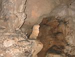
Some other places of interests are Ta Ko Bi Cave (ถ้ำตะโค๊ะบิ), a cave formerly used by Communist Party of Thailand
; Doi Hua Mot (ดอยหัวหมด), view point above cloud attitude; Ban Pa La Ta (บ้านปะละทะ), a Karen village dated back to over 250 years ago.
), which are further subdivided into 38 villages (Muban
). The township (thesaban tambon) Umphang covers parts of the tambon Umphang.
Amphoe
An amphoe is the second level administrative subdivision of Thailand. Usually translated as district, amphoe make up the provinces, and are analogous to a county seat...
) of Tak Province
Tak Province
Tak is one of the northern provinces of Thailand. Neighboring provinces are Mae Hong Son, Chiang Mai, Lamphun, Lampang, Sukhothai, Kamphaeng Phet, Nakhon Sawan, Uthai Thani and Kanchanaburi...
, Thailand
Thailand
Thailand , officially the Kingdom of Thailand , formerly known as Siam , is a country located at the centre of the Indochina peninsula and Southeast Asia. It is bordered to the north by Burma and Laos, to the east by Laos and Cambodia, to the south by the Gulf of Thailand and Malaysia, and to the...
at the Thai-Myanmar
Myanmar
Burma , officially the Republic of the Union of Myanmar , is a country in Southeast Asia. Burma is bordered by China on the northeast, Laos on the east, Thailand on the southeast, Bangladesh on the west, India on the northwest, the Bay of Bengal to the southwest, and the Andaman Sea on the south....
border. It is also the name of the town center of the district.
Neighboring districts are (North from clockwise): Amphoe Phop Phra
Amphoe Phop Phra
Phop Phra is a district in the southwestern part of Tak Province, northern Thailand.-History:The whole area of Phop Phra was originally Tambon Chong Khaep of Mae Sot district. Due to the large size of Mae Sot and problems with communist insurgents, the government created a separate administration...
; Amphoe Khlong Lan
Amphoe Khlong Lan
Khlong Lan is the westernmost district of Kamphaeng Phet Province, northern Thailand.-History:The area was originally part of Mueang Kamphaeng Phet district, then named Tambon Pong Nam Ron. The tambon Khlong Lan and Pong Nam Ron were upgraded to a minor district on June 1 1977...
and Amphoe Pang Sila Thong
Amphoe Pang Sila Thong
Pang Sila Thong is the southwesternmost district of Kamphaeng Phet Province, northern Thailand.-History:The government split Tambon Pang Ta Wai, Hin Dat and Pho Thong from Khlong Khlung district and created the minor district Pang Sila Thong on May 31, 1993...
of Kamphaeng Phet Province
Kamphaeng Phet Province
Kamphaeng Phet is one of the provinces of Thailand, located in the north of the country. Neighboring provinces are Sukhothai, Phitsanulok, Phichit, Nakhon Sawan and Tak.- Etymology :...
; Amphoe Mae Wong
Amphoe Mae Wong
Mae Wong is a district in the western part of Nakhon Sawan Province, northern Thailand.-History:The minor district Mae Wong was created on April 1 1992, when the six tambon Mae Wong, Mae Le, Wang San, Khao Chon Kan, Pang Sawan and Huai Nam Hom were split off from Lat Yao district...
and King Amphoe Mae Poen
King Amphoe Mae Poen
Mae Poen is a district in the western part of Nakhon Sawan Province, northern Thailand.-History:Tambon Mae Poen was separated from Lat Yao district to become a minor district on July 15, 1996....
of Nakhon Sawan Province
Nakhon Sawan Province
Nakhon Sawan is one of the provinces of Thailand. Neighboring provinces are Kamphaeng Phet, Phichit, Phetchabun, Lop Buri, Sing Buri, Chai Nat, Uthai Thani and Tak.- Etymology :...
; Amphoe Ban Rai
Amphoe Ban Rai
Ban Rai is a district in the Uthai Thani Province in western Thailand.-Geography:The district covers more than half of the whole province Uthai Thani, and is also the third-largest district of Thailand areawise...
of Uthai Thani Province
Uthai Thani Province
Uthai Thani is one of the provinces of Thailand. Neighboring provinces are Nakhon Sawan, Chai Nat, Suphan Buri, Kanchanaburi and Tak.-Geography:...
; and Amphoe Thong Pha Phum
Amphoe Thong Pha Phum
Thong Pha Phum is a district in the northern part of Kanchanaburi Province, central Thailand.-History:At first Thong Pha Phum was the minor district Sangkhla Buri, a subordinate of Wang Ka district. In 1939 the name Sangkhla Buri was assigned to Wang Ka, while the minor district was renamed to...
and Amphoe Sangkhla Buri
Amphoe Sangkhla Buri
Sangkhla Buri is a district in the Kanchanaburi Province in western Thailand.-Geography:Sangkhla Buri is located in the far west of the province, at the boundary to Myanmar. The Three Pagodas Pass is the border crossing station to Myanmar...
of Kanchanaburi Province
Kanchanaburi Province
- History :Archaeology found in Kanchanaburi dates back to the 4th century which proves of trade with surrounding countries even in that time. Very little is also historically known about the actual Khmer influence in Kanchanaburi but there is evidence of their occupation with Prasat Muang Singh –...
. The western edge of the district has a long boundary with Burma (Myanmar
Myanmar
Burma , officially the Republic of the Union of Myanmar , is a country in Southeast Asia. Burma is bordered by China on the northeast, Laos on the east, Thailand on the southeast, Bangladesh on the west, India on the northwest, the Bay of Bengal to the southwest, and the Andaman Sea on the south....
). Surrounded by national parks and wildlife reserves, it is one of the least accessible district in Thailand. Nevertheless, it has one major tourist attraction, Thi Lo Su Waterfall (น้ำตกทีลอซู), the largest waterfall of Thailand.
History
Umphang was established as a district in 1898. It was named Amphoe Mae Klong (อำเภอแม่กลอง) back then and part of Uthai Thani Province. In 1906 it was renamed Amphoe Umphang and moved to Kamphaeng Phet Province. Its status was changed to King Amphoe and moved to Tak Province effective January 1 1926. Finally in 1959 it is promoted back to AmphoeAmphoe
An amphoe is the second level administrative subdivision of Thailand. Usually translated as district, amphoe make up the provinces, and are analogous to a county seat...
status.
Etymology
It was speculated that the name Umphang came from Karen word Umpa, meaning the act of opening bamboo container, this was performed by Burmese to show passport stored in the bamboo to Thai immigration officers.Geography
Most of Umphang is mountainous, geographically separated from the east part of Tak Province via Thanon Thongchai Mountain Range (ทิวเขาถนนธงชัย). The southern part of Umphang belongs to Thungyai Naresuan Wildlife SanctuaryThungyai Naresuan Wildlife Sanctuary
The Wildlife Sanctuary Thung Yai Naresuan is a protected area in Thailand in the northern part of Kanchanaburi province and the southern part of Tak province...
while the central part near Umphang town is Umphang Wildlife Sanctuary. Directly east of Umphang Wildlife Sanctuary is Mae Wong National Park
Mae Wong National Park
Mae Wong National Park is a national park in Thailand.-Description:Mae Wong National Park is situated in the Thanon Thong Chai Mountain Range....
(in Tak and Kamphaeng Phet Province) and Khlong Lan National Park
Khlong Lan National Park
Khlong Lan National Park is a national park in Thailand.-Description:Khlong Lan National Park is situated in the Thanon Thong Chai Mountain Range....
(in Kamphaeng Phet Province). The area, due to its difficulty of access, were used as a base of Communist Party of Thailand
Communist Party of Thailand
The Communist Party of Thailand - CPT was a Marxist-Leninist, Communist political party in Thailand, active from 1942 until the 1990s. Initially known as Communist Party of Siam the party was founded officially on the 1st of December 1942, although communist activism in the country began as early...
.
An important river in Umphang is Klong River
Mae Klong
The Mae Klong is a river in western Thailand. The river begins at the confluence of the Khwae Noi or Khwae Sai Yok and the Khwae Yai River or Khwae Si Sawat in Kanchanaburi, pass Ratchaburi Province and empties into the Gulf of Thailand in Samut Songkhram....
(แม่น้ำกลอง) which originates here and flows southward into Kanchanaburi Province
Kanchanaburi Province
- History :Archaeology found in Kanchanaburi dates back to the 4th century which proves of trade with surrounding countries even in that time. Very little is also historically known about the actual Khmer influence in Kanchanaburi but there is evidence of their occupation with Prasat Muang Singh –...
.
Demographics
A large number of the population are hill tribes with Karen peopleKaren people
The Karen or Kayin people , are a Sino-Tibetan language speaking ethnic group which resides primarily in southern and southeastern Burma . The Karen make up approximately 7 percent of the total Burmese population of approximately 50 million people...
making up the largest proportion. As Karens were the original settlers here before Thais began to migrate into the area, many place names are in Karen language.
Transportation
Mae Sot
- External links :* * : an audio documentary.* *...
-Umphang) is the only road linking Umphang to other parts of Thailand. Another highway, Highway 1167, connect Umphang town to the Burmese border. Highway 1090, 164 km in total, has two lanes during much of the way and contains 1,219 curves, a number proudly displayed at numerous places in Umphang. It is one of the toughest roads for those who suffer from motion sickness
Motion sickness
Motion sickness or kinetosis, also known as travel sickness, is a condition in which a disagreement exists between visually perceived movement and the vestibular system's sense of movement...
. The journey through this highway takes about 3 to 4 hours.
There was a Highway 1117 (Khlong Lan
Amphoe Khlong Lan
Khlong Lan is the westernmost district of Kamphaeng Phet Province, northern Thailand.-History:The area was originally part of Mueang Kamphaeng Phet district, then named Tambon Pong Nam Ron. The tambon Khlong Lan and Pong Nam Ron were upgraded to a minor district on June 1 1977...
-Umphang) project that would have provided a connection from Amphoe Khlong Lan
Amphoe Khlong Lan
Khlong Lan is the westernmost district of Kamphaeng Phet Province, northern Thailand.-History:The area was originally part of Mueang Kamphaeng Phet district, then named Tambon Pong Nam Ron. The tambon Khlong Lan and Pong Nam Ron were upgraded to a minor district on June 1 1977...
, Kamphaeng Phet Province
Kamphaeng Phet Province
Kamphaeng Phet is one of the provinces of Thailand, located in the north of the country. Neighboring provinces are Sukhothai, Phitsanulok, Phichit, Nakhon Sawan and Tak.- Etymology :...
but the project was shelved in 1987 pending an environmental study. About 115 km of the highway beginning from Khlong Lan was already constructed, leaving the last 28 km on the Umphang side where it stopped in Umphang Wildlife Sanctuary in 1990. Suggestion to finish this project surfaced a few time but was eventually rejected due to the virgin forest the last 28 km section must cut through. Another project linking Umphang to Amphoe Sangkhla Buri
Amphoe Sangkhla Buri
Sangkhla Buri is a district in the Kanchanaburi Province in western Thailand.-Geography:Sangkhla Buri is located in the far west of the province, at the boundary to Myanmar. The Three Pagodas Pass is the border crossing station to Myanmar...
, Kanchanaburi Province
Kanchanaburi Province
- History :Archaeology found in Kanchanaburi dates back to the 4th century which proves of trade with surrounding countries even in that time. Very little is also historically known about the actual Khmer influence in Kanchanaburi but there is evidence of their occupation with Prasat Muang Singh –...
was proposed in 2004 but was immediately rejected.
Beside the highway 1090, there is a municipal airport in Umphang.
Places
Waterfall
A waterfall is a place where flowing water rapidly drops in elevation as it flows over a steep region or a cliff.-Formation:Waterfalls are commonly formed when a river is young. At these times the channel is often narrow and deep. When the river courses over resistant bedrock, erosion happens...
of Thailand, containing many smaller drops combined together for a magnificent view. Its height is about 200 meters and total width is about 400 meters. It is most beautiful during rainy season from June to November because of the larger water flow. However during this period, the road access to the waterfall is closed for safety reason and some hiking
Hiking
Hiking is an outdoor activity which consists of walking in natural environments, often in mountainous or other scenic terrain. People often hike on hiking trails. It is such a popular activity that there are numerous hiking organizations worldwide. The health benefits of different types of hiking...
is required. The peak season for tourism is in December and January where the water level is still high and the road to waterfall (25 km) is open for public. Only cars with four wheel drive can pass this steep and slipperly road. An alternative way to reach the waterfall is by whitewater rafting
Whitewater
Whitewater is formed in a rapid, when a river's gradient increases enough to disturb its laminar flow and create turbulence, i.e. form a bubbly, or aerated and unstable current; the frothy water appears white...
downstream along the calm section of Klong River and then continue journey either on foot or by car for another about 12 km. Travelling this way, two waterfalls dropping into Klong River will be seen: Thi Lo Jo Waterfall (น้ำตกทีลอจ่อ), and Sai Rung Waterfall (น้ำตกสายรุ้ง). The name Thi Lo Su, in Karen language, means giant waterfall or black waterfall.
It is only recently that Thi Lo Le Waterfall (น้ำตกทีลอเล) is promoted as an attraction for those who prefer adventure. It is a waterfall dropping directly into Klong River located deep in Thungyai Naresuan Wildlife Sanctuary
Thungyai Naresuan Wildlife Sanctuary
The Wildlife Sanctuary Thung Yai Naresuan is a protected area in Thailand in the northern part of Kanchanaburi province and the southern part of Tak province...
with no road access. Only traveling with tour companies is possible. The journey to the waterfall typically involves white water rafting along Klong River of about 40 km through rapids of Class 4 or 5 while the journey back is usually by riding elephants. The trip takes 2 or 3 days.
Some other places of interests are Ta Ko Bi Cave (ถ้ำตะโค๊ะบิ), a cave formerly used by Communist Party of Thailand
Communist Party of Thailand
The Communist Party of Thailand - CPT was a Marxist-Leninist, Communist political party in Thailand, active from 1942 until the 1990s. Initially known as Communist Party of Siam the party was founded officially on the 1st of December 1942, although communist activism in the country began as early...
; Doi Hua Mot (ดอยหัวหมด), view point above cloud attitude; Ban Pa La Ta (บ้านปะละทะ), a Karen village dated back to over 250 years ago.
Administration
The district is subdivided into 6 subdistricts (TambonTambon
Tambon is a local government unit in Thailand. Below district and province , they form the third administrative subdivision level. As of the 2009 there are 7255 tambon, not including the 169 khwaeng of Bangkok, which are set at the same administrative level, thus every district contains 8-10 tambon...
), which are further subdivided into 38 villages (Muban
Muban
Muban is the lowest administrative subdivision of Thailand. Usually translated as village, they are the subdivision of tambon. As of 2008, there are 74944 administrative villages in Thailand. As of the 1990 census, the average village consisted of 144 households or 746 persons.A muban does not...
). The township (thesaban tambon) Umphang covers parts of the tambon Umphang.
| No. | Name | Thai name | Villages | Inh. Population A population is all the organisms that both belong to the same group or species and live in the same geographical area. The area that is used to define a sexual population is such that inter-breeding is possible between any pair within the area and more probable than cross-breeding with individuals... |
|
|---|---|---|---|---|---|
| 1. | Umphang | อุ้มผาง | 6 | 4138 | |
| 2. | Nong Luang | หนองหลวง | 4 | 2013 | |
| 3. | Mokro | โมโกร | 7 | 5488 | |
| 4. | Mae Chan | แม่จัน | 12 | 10246 | |
| 5. | Mae Lamung | แม่ละมุ้ง | 5 | 1650 | |
| 6. | Mae Khlong | แม่กลอง | 4 | 2222 |