
Amphoe Sai Yok
Encyclopedia
Sai Yok is a district (Amphoe
) in the Kanchanaburi province
in western Thailand
.
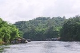
 The district is located in the valley of the Khwae Noi river. It borders to Myanmar
to the south. Along the river the Death Railway
runs till Nam Tok. The Sai Yok National Park was created on October 27, 1980 and covers an area of about 500 km². The most famous sight in the park is the Sai Yok waterfall
.
Neighboring are (from north clockwise) Thong Pha Phum
, Si Sawat
, Mueang Kanchanaburi
of Kanchanaburi Province and Tanintharyi Division
of Myanmar
.
, which shows the westernmost Khmer
style temple complex. Also popular for tourists is the Tiger Temple
.
), which are further subdivided into 55 villages (muban
). There are two townships (thesaban tambon) - Lum Sum covers parts of tambon Lum Sum, and Nam Tok Sai Yok Noi parts of tambon Tha Sao. There are further 7 Tambon administrative organizations (TAO).
Amphoe
An amphoe is the second level administrative subdivision of Thailand. Usually translated as district, amphoe make up the provinces, and are analogous to a county seat...
) in the Kanchanaburi province
Kanchanaburi Province
- History :Archaeology found in Kanchanaburi dates back to the 4th century which proves of trade with surrounding countries even in that time. Very little is also historically known about the actual Khmer influence in Kanchanaburi but there is evidence of their occupation with Prasat Muang Singh –...
in western Thailand
Thailand
Thailand , officially the Kingdom of Thailand , formerly known as Siam , is a country located at the centre of the Indochina peninsula and Southeast Asia. It is bordered to the north by Burma and Laos, to the east by Laos and Cambodia, to the south by the Gulf of Thailand and Malaysia, and to the...
.
Geography
Myanmar
Burma , officially the Republic of the Union of Myanmar , is a country in Southeast Asia. Burma is bordered by China on the northeast, Laos on the east, Thailand on the southeast, Bangladesh on the west, India on the northwest, the Bay of Bengal to the southwest, and the Andaman Sea on the south....
to the south. Along the river the Death Railway
Death Railway
The Burma Railway, also known as the Death Railway, the Thailand–Burma Railway and similar names, was a railway between Bangkok, Thailand, and Rangoon, Burma , built by the Empire of Japan during World War II, to support its forces in the Burma campaign.Forced labour was used in its construction...
runs till Nam Tok. The Sai Yok National Park was created on October 27, 1980 and covers an area of about 500 km². The most famous sight in the park is the Sai Yok waterfall
Sai Yok waterfall
Sai Yok Noi is a waterfall in the Sai Yok district of Kanchanaburi Province, Thailand, near the small town Nam Tok Sai Yok Noi. It is the most popular attraction of the Sai Yok National Park for domestic and foreign tourists alike, in part because it lies next to the province's trunk road alongside...
.
Neighboring are (from north clockwise) Thong Pha Phum
Amphoe Thong Pha Phum
Thong Pha Phum is a district in the northern part of Kanchanaburi Province, central Thailand.-History:At first Thong Pha Phum was the minor district Sangkhla Buri, a subordinate of Wang Ka district. In 1939 the name Sangkhla Buri was assigned to Wang Ka, while the minor district was renamed to...
, Si Sawat
Amphoe Si Sawat
Si Sawat is a district in the Kanchanaburi Province in western Thailand.- Geography :Neighboring districts are Ban Rai of Uthai Thani Province, Dan Chang of Suphanburi Province, Nong Prue, Bo Phloi, Kanchanaburi, Sai Yok and Thong Pha Phum of Kanchanburi Province.The district is dominated by the...
, Mueang Kanchanaburi
Amphoe Mueang Kanchanaburi
Mueang Kanchanaburi is the capital district of Kanchanaburi Province, central Thailand.-History:Mueang Kanchanaburi was changed status to be the capital district of Kanchanaburi province in 1913....
of Kanchanaburi Province and Tanintharyi Division
Tanintharyi Division
Tanintharyi Region , is an administrative region of Myanmar, covering the long narrow southern part of the country on the Kra Isthmus. It borders with the Andaman Sea to the west and with the Tenasserim Hills, beyond which lies Thailand, to the east. To the north is the Mon State. The capital of...
of Myanmar
Myanmar
Burma , officially the Republic of the Union of Myanmar , is a country in Southeast Asia. Burma is bordered by China on the northeast, Laos on the east, Thailand on the southeast, Bangladesh on the west, India on the northwest, the Bay of Bengal to the southwest, and the Andaman Sea on the south....
.
Sights
Apart from the nature of the Kwae Noi river valley, the other main attraction is the Mueang Sing historical parkMueang Sing historical park
Mueang Sing ) is a historical park in the Sai Yok district, Kanchanaburi province, Thailand. The remains of two Khmer temples date to the 13th and 14th century. It was declared a historical park in 1987....
, which shows the westernmost Khmer
Khmer Empire
The Khmer Empire was one of the most powerful empires in Southeast Asia. The empire, which grew out of the former kingdom of Chenla, at times ruled over and/or vassalized parts of modern-day Laos, Thailand, Vietnam, Burma, and Malaysia. Its greatest legacy is Angkor, the site of the capital city...
style temple complex. Also popular for tourists is the Tiger Temple
Tiger Temple
Tiger Temple, or Wat Pha Luang Ta Bua, is a Theravada Buddhist temple in western Thailand that was founded in 1994 as a forest temple and sanctuary for wild animals, among them several tigers.-Location:...
.
Administration
The district is subdivided into 7 subdistricts (tambonTambon
Tambon is a local government unit in Thailand. Below district and province , they form the third administrative subdivision level. As of the 2009 there are 7255 tambon, not including the 169 khwaeng of Bangkok, which are set at the same administrative level, thus every district contains 8-10 tambon...
), which are further subdivided into 55 villages (muban
Muban
Muban is the lowest administrative subdivision of Thailand. Usually translated as village, they are the subdivision of tambon. As of 2008, there are 74944 administrative villages in Thailand. As of the 1990 census, the average village consisted of 144 households or 746 persons.A muban does not...
). There are two townships (thesaban tambon) - Lum Sum covers parts of tambon Lum Sum, and Nam Tok Sai Yok Noi parts of tambon Tha Sao. There are further 7 Tambon administrative organizations (TAO).
| No. | Name | Thai name | Villages | Inh. Population A population is all the organisms that both belong to the same group or species and live in the same geographical area. The area that is used to define a sexual population is such that inter-breeding is possible between any pair within the area and more probable than cross-breeding with individuals... |
|
|---|---|---|---|---|---|
| 1. | Lum Sum | ลุ่มสุ่ม | 10 | 8,715 | |
| 2. | Tha Sao | ท่าเสา | 11 | 11,331 | |
| 3. | Sing | สิงห์ | 6 | 4,478 | |
| 4. | Sai Yok | ไทรโยค | 9 | 8,847 | |
| 5. | Wang Krachae | วังกระแจะ | 9 | 7,283 | |
| 6. | Si Mongkhon | ศรีมงคล | 6 | 7,144 | |
| 7. | Bongti | บ้องตี้ | 4 | 3,894 |
Trivia
- Sai Yok was the location of shooting the Vietnam scenes of the 1978 film The Deer HunterThe Deer HunterThe Deer Hunter is a 1978 drama film co-written and directed by Michael Cimino about a trio of Russian American steel worker friends and their infantry service in the Vietnam War. The film stars Robert De Niro, Christopher Walken, Meryl Streep, John Savage, John Cazale, and George Dzundza...
.
- Sai Yok was mention in song "Mon Sai Yok" (มนต์ไทรโยค - Magic Of Sai Yok) By The Famous Thai Pop rockPop rockPop rock is a music genre which mixes a catchy pop style and light lyrics in its guitar-based rock songs. There are varying definitions of the term, ranging from a slower and mellower form of rock music to a subgenre of pop music...
Band "The Innocent" from an album "Yu Hor" (อยู่หอ - Stay Dorm) in 1982. The song is about how delight time and trip while being at Sai Yok.