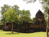
Mueang Sing historical park
Encyclopedia
Mueang Sing is a historical park
in the Sai Yok district
, Kanchanaburi province
, Thailand
. The remains of two Khmer
temples date to the 13th and 14th century. It was declared a historical park in 1987.
Built in the Bayon
style, the temple relates to the Khmer kingdom in the reign of King Jayavarman VII
(1180 to 1219). A stone inscription of Prince Vira Kumara praising his father, 23 cities are named. One of these cities was named Srichaiya Singhapura, which some scholars identify with Mueang Sing.
The name Mueang Sing first showed in the chronicles of the reign of King Rama I (1782-1809), when it was a fortified town protecting the town Kanchanaburi
. In the reform of provincial administration at the end of the 19th century its status was reduced from Mueang to Tambon
(commune).
Four monuments are existing inside the area of 736,000 m² enclosed by a laterite
wall. The southern wall winds along the Khwae Noi river course, while the other three sides are quadratic. The main monument is in the center of the area, northwest of this is are the foundations of a second temple building. The other two monuments are of much smaller scale.
Historical parks of Thailand
Historical parks in Thailand are managed by the Fine Arts Department, a sub-division of the Ministry of Education. There are currently ten parks, with four them registered as World Heritage Sites by the UNESCO....
in the Sai Yok district
Amphoe Sai Yok
Sai Yok ) is a district in the Kanchanaburi province in western Thailand.- Geography :The district is located in the valley of the Khwae Noi river. It borders to Myanmar to the south. Along the river the Death Railway runs till Nam Tok. The Sai Yok National Park was created on October 27, 1980...
, Kanchanaburi province
Kanchanaburi Province
- History :Archaeology found in Kanchanaburi dates back to the 4th century which proves of trade with surrounding countries even in that time. Very little is also historically known about the actual Khmer influence in Kanchanaburi but there is evidence of their occupation with Prasat Muang Singh –...
, Thailand
Thailand
Thailand , officially the Kingdom of Thailand , formerly known as Siam , is a country located at the centre of the Indochina peninsula and Southeast Asia. It is bordered to the north by Burma and Laos, to the east by Laos and Cambodia, to the south by the Gulf of Thailand and Malaysia, and to the...
. The remains of two Khmer
Khmer Empire
The Khmer Empire was one of the most powerful empires in Southeast Asia. The empire, which grew out of the former kingdom of Chenla, at times ruled over and/or vassalized parts of modern-day Laos, Thailand, Vietnam, Burma, and Malaysia. Its greatest legacy is Angkor, the site of the capital city...
temples date to the 13th and 14th century. It was declared a historical park in 1987.
Built in the Bayon
Bayon
The Bayon is a well-known and richly decorated Khmer temple at Angkor in Cambodia. Built in the late 12th century or early 13th century as the official state temple of the Mahayana Buddhist King Jayavarman VII, the Bayon stands at the centre of Jayavarman's capital, Angkor Thom...
style, the temple relates to the Khmer kingdom in the reign of King Jayavarman VII
Jayavarman VII
Jayavarman VII was a king of the Khmer Empire in present day Siem Reap, Cambodia. He was the son of King Dharanindravarman II and Queen Sri Jayarajacudamani. He married Jayarajadevi and then, after her death, married her sister Indradevi...
(1180 to 1219). A stone inscription of Prince Vira Kumara praising his father, 23 cities are named. One of these cities was named Srichaiya Singhapura, which some scholars identify with Mueang Sing.
The name Mueang Sing first showed in the chronicles of the reign of King Rama I (1782-1809), when it was a fortified town protecting the town Kanchanaburi
Kanchanaburi
Kanchanaburi ) is a town in the west of Thailand and the capital of Kanchanaburi province. In 2006 it had a population of 31,327...
. In the reform of provincial administration at the end of the 19th century its status was reduced from Mueang to Tambon
Tambon
Tambon is a local government unit in Thailand. Below district and province , they form the third administrative subdivision level. As of the 2009 there are 7255 tambon, not including the 169 khwaeng of Bangkok, which are set at the same administrative level, thus every district contains 8-10 tambon...
(commune).
Four monuments are existing inside the area of 736,000 m² enclosed by a laterite
Laterite
Laterites are soil types rich in iron and aluminium, formed in hot and wet tropical areas. Nearly all laterites are rusty-red because of iron oxides. They develop by intensive and long-lasting weathering of the underlying parent rock...
wall. The southern wall winds along the Khwae Noi river course, while the other three sides are quadratic. The main monument is in the center of the area, northwest of this is are the foundations of a second temple building. The other two monuments are of much smaller scale.

