
Amphoe Si Sawat
Encyclopedia
Si Sawat is a district (Amphoe
) in the Kanchanaburi Province
in western Thailand
.
of Uthai Thani Province
, Dan Chang
of Suphanburi Province
, Nong Prue
, Bo Phloi
, Kanchanaburi
, Sai Yok
and Thong Pha Phum
of Kanchanburi Province.
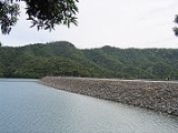
 The district is dominated by the Si Nakharin reservoir, which is also part of the Khuean Sri Nakarin National Park. The 140-metre high Si Nakharin Dam was finished in 1980 and creates a 419-square-kilometre lake of the Kwae Yai River. The dam has received criticism for being built on the Si Sawat fault line.
 To the south of the district is the Erawan National Park
, most famous for the Erawan waterfall.
), which are further subdivided into 33 villages (muban
). The township (thesaban tambon) Erawan covers parts of tambon Tha Kradan. There are six further Tambon administrative organizations (TAO).
Amphoe
An amphoe is the second level administrative subdivision of Thailand. Usually translated as district, amphoe make up the provinces, and are analogous to a county seat...
) in the Kanchanaburi Province
Kanchanaburi Province
- History :Archaeology found in Kanchanaburi dates back to the 4th century which proves of trade with surrounding countries even in that time. Very little is also historically known about the actual Khmer influence in Kanchanaburi but there is evidence of their occupation with Prasat Muang Singh –...
in western Thailand
Thailand
Thailand , officially the Kingdom of Thailand , formerly known as Siam , is a country located at the centre of the Indochina peninsula and Southeast Asia. It is bordered to the north by Burma and Laos, to the east by Laos and Cambodia, to the south by the Gulf of Thailand and Malaysia, and to the...
.
Geography
Neighboring districts are (from the north clockwise) Ban RaiAmphoe Ban Rai
Ban Rai is a district in the Uthai Thani Province in western Thailand.-Geography:The district covers more than half of the whole province Uthai Thani, and is also the third-largest district of Thailand areawise...
of Uthai Thani Province
Uthai Thani Province
Uthai Thani is one of the provinces of Thailand. Neighboring provinces are Nakhon Sawan, Chai Nat, Suphan Buri, Kanchanaburi and Tak.-Geography:...
, Dan Chang
Amphoe Dan Chang
Dan Chang is the northwesternmost district of Suphanburi Province, central Thailand.- History :Dan Chang was created as a minor district on August 30, 1974 by splitting off the three tambon Dan Chang, Ong Phra and Huai Khamin from Doem Bang Nang Buat district...
of Suphanburi Province
Suphanburi Province
Suphan Buri is one of the central provinces of Thailand. Neighboring provinces are Uthai Thani, Chai Nat, Sing Buri, Ang Thong, Phra Nakhon Si Ayutthaya, Nakhon Pathom and Kanchanaburi.- Etymology :...
, Nong Prue
Amphoe Nong Prue
Nong Prue is a district in the northeastern part of Kanchanaburi Province, central Thailand.The district is named after the Prue plant, Cyperus sp.-History:...
, Bo Phloi
Amphoe Bo Phloi
-History:The minor district Bo Phloi was created by splitting some part of Mueang Kanchanaburi district. It was upgraded to a full district on July 16 1963.-Geography:...
, Kanchanaburi
Amphoe Mueang Kanchanaburi
Mueang Kanchanaburi is the capital district of Kanchanaburi Province, central Thailand.-History:Mueang Kanchanaburi was changed status to be the capital district of Kanchanaburi province in 1913....
, Sai Yok
Amphoe Sai Yok
Sai Yok ) is a district in the Kanchanaburi province in western Thailand.- Geography :The district is located in the valley of the Khwae Noi river. It borders to Myanmar to the south. Along the river the Death Railway runs till Nam Tok. The Sai Yok National Park was created on October 27, 1980...
and Thong Pha Phum
Amphoe Thong Pha Phum
Thong Pha Phum is a district in the northern part of Kanchanaburi Province, central Thailand.-History:At first Thong Pha Phum was the minor district Sangkhla Buri, a subordinate of Wang Ka district. In 1939 the name Sangkhla Buri was assigned to Wang Ka, while the minor district was renamed to...
of Kanchanburi Province.
Erawan National Park
Erawan National Park is a 550-square-kilometer park in western Thailand located in Kanchanaburi Province, Amphoe Si Sawat in the tambon Tha Kradan. Founded in 1975, it is Thailand's 12th national park....
, most famous for the Erawan waterfall.
Administration
The district is subdivided into six subdistricts (tambonTambon
Tambon is a local government unit in Thailand. Below district and province , they form the third administrative subdivision level. As of the 2009 there are 7255 tambon, not including the 169 khwaeng of Bangkok, which are set at the same administrative level, thus every district contains 8-10 tambon...
), which are further subdivided into 33 villages (muban
Muban
Muban is the lowest administrative subdivision of Thailand. Usually translated as village, they are the subdivision of tambon. As of 2008, there are 74944 administrative villages in Thailand. As of the 1990 census, the average village consisted of 144 households or 746 persons.A muban does not...
). The township (thesaban tambon) Erawan covers parts of tambon Tha Kradan. There are six further Tambon administrative organizations (TAO).
| 1. | Na Suan | นาสวน | 4,119 | ||
| 2. | Dan Mae Chalaep | ด่านแม่แฉลบ | 4,431 | ||
| 3. | Nong Pet | หนองเป็ด | 2,430 | ||
| 4. | Tha Kradan | ท่ากระดาน | 5,716 | ||
| 5. | Khao Chot | เขาโจด | 3,770 | ||
| 6. | Mae Krabung | แม่กระบุง | 3,234 |