
Amphoe Don Sak
Encyclopedia
Don Sak is a district (Amphoe
) in eastern Surat Thani Province
. The ferry port to Samui
Island is located in the district.
Neighboring districts are (from the east clockwise) Khanom
and Sichon
(both in Nakhon Si Thammarat Province
) and the district Kanchanadit
. To the north is the Gulf of Thailand
, with islands belonging to the Ko Samui
district.
, Nakhon Si Thammarat province. In 1929 the two subdistricts Don Sak and Chaiyakhram were reassigned to Kanchanadit district. The district was created as a minor district (King Amphoe) on March 24, 1969 by splitting the two tambon Don Sak and Chonlakhram from Kanchanadit district. The citizen of tambon Chaiyakhram then asked to be included into the new district as well, which was done on September 1 of the same year. On November 16, 1971 it was promoted to full district status. The fourth tambon Pak Prak was created on July 14 1978 from tambon Don Sak and Chaiyakhram.
), which are further subdivided into 40 villages (muban
). All four tambon are administrated by a Tambon Administrative Organization (TAO); Don Sak itself has township (thesaban tambon) status and covers part of the tambon Don Sak.
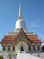 Wat Khao Suwan Pradit (Thai: วัดเขาสุวรรณประดิษฐ์) is a buddhist temple
located on a hill about 1 kilometer from the town Don Sak. The temple was founded in 1982 by Luang Pho Choi, a highly revered monk of southern Thailand. On top of the hill is a 45 meter high chedi
, which also contains Buddha relics which came from Wat Phra Kiat (Amphoe Hot
, Chiang Mai Province
); the platform around the chedi also offers a great view over the town and the Gulf of Thailand.
Amphoe
An amphoe is the second level administrative subdivision of Thailand. Usually translated as district, amphoe make up the provinces, and are analogous to a county seat...
) in eastern Surat Thani Province
Surat Thani Province
Surat Thani is the largest of the southern provinces of Thailand, on the eastern shore of the Gulf of Thailand. Surat Thani means City of Good People, the title given to the city by King Vajiravudh ....
. The ferry port to Samui
Ko Samui
Ko Samui island of Surat Thani Province , or often, simply Samui as it is referred to by locals, is an island off the east coast of the Kra Isthmus in Thailand, close to the mainland Surat Thani town. It is Thailand's second largest island, with an area of 228.7 km2 and a population of over...
Island is located in the district.
Neighboring districts are (from the east clockwise) Khanom
Amphoe Khanom
Khanom is the northernmost district of Nakhon Si Thammarat Province, southern Thailand.-Geography:The district is located in the north of the province. To the west is Surat Thani Province, while to the north and east is the Gulf of Thailand...
and Sichon
Amphoe Sichon
Sichon is a district of Nakhon Si Thammarat Province, southern Thailand.-Geography:The district is located in the northern part of the province. Neighboring districts are Tha Sala and Nopphitam of Nakhon Si Thammarat Province, Kanchanadit and Don Sak of Surat Thani Province, and Khanom of Nakhon...
(both in Nakhon Si Thammarat Province
Nakhon Si Thammarat Province
Nakhon Si Thammarat is one of the southern provinces of Thailand, at the eastern shore of the Gulf of Thailand...
) and the district Kanchanadit
Amphoe Kanchanadit
Kanchanadit is a district in the province Surat Thani in the south of Thailand.-History:Originally the town was named Thathong and was located at the shore of Khlong Thathong Mai . During the reign of King Nangklao the town was moved because its location was malaria-infested, and renamed to...
. To the north is the Gulf of Thailand
Gulf of Thailand
The Gulf of Thailand , also known in to Malays as Teluk Siam literally meant Gulf of Siam, is a shallow arm of the South China Sea.-Geography:...
, with islands belonging to the Ko Samui
Ko Samui
Ko Samui island of Surat Thani Province , or often, simply Samui as it is referred to by locals, is an island off the east coast of the Kra Isthmus in Thailand, close to the mainland Surat Thani town. It is Thailand's second largest island, with an area of 228.7 km2 and a population of over...
district.
History
Originally, the area of the district was part of Sichon districtAmphoe Sichon
Sichon is a district of Nakhon Si Thammarat Province, southern Thailand.-Geography:The district is located in the northern part of the province. Neighboring districts are Tha Sala and Nopphitam of Nakhon Si Thammarat Province, Kanchanadit and Don Sak of Surat Thani Province, and Khanom of Nakhon...
, Nakhon Si Thammarat province. In 1929 the two subdistricts Don Sak and Chaiyakhram were reassigned to Kanchanadit district. The district was created as a minor district (King Amphoe) on March 24, 1969 by splitting the two tambon Don Sak and Chonlakhram from Kanchanadit district. The citizen of tambon Chaiyakhram then asked to be included into the new district as well, which was done on September 1 of the same year. On November 16, 1971 it was promoted to full district status. The fourth tambon Pak Prak was created on July 14 1978 from tambon Don Sak and Chaiyakhram.
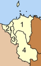
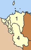
Administrative divisions
The district Don Sak is subdivided into 4 subdistricts (tambonTambon
Tambon is a local government unit in Thailand. Below district and province , they form the third administrative subdivision level. As of the 2009 there are 7255 tambon, not including the 169 khwaeng of Bangkok, which are set at the same administrative level, thus every district contains 8-10 tambon...
), which are further subdivided into 40 villages (muban
Muban
Muban is the lowest administrative subdivision of Thailand. Usually translated as village, they are the subdivision of tambon. As of 2008, there are 74944 administrative villages in Thailand. As of the 1990 census, the average village consisted of 144 households or 746 persons.A muban does not...
). All four tambon are administrated by a Tambon Administrative Organization (TAO); Don Sak itself has township (thesaban tambon) status and covers part of the tambon Don Sak.
|
 |
Sights
Wat
A wat is a monastery temple in Cambodia, Thailand, or Laos. The word "wat" means "school".- Introduction :...
located on a hill about 1 kilometer from the town Don Sak. The temple was founded in 1982 by Luang Pho Choi, a highly revered monk of southern Thailand. On top of the hill is a 45 meter high chedi
Stupa
A stupa is a mound-like structure containing Buddhist relics, typically the remains of Buddha, used by Buddhists as a place of worship....
, which also contains Buddha relics which came from Wat Phra Kiat (Amphoe Hot
Amphoe Hot
Hot is a district in the southern part of Chiang Mai Province in northern Thailand.-Geography:Neighboring districts are Mae Chaem, Chom Thong of Chiang Mai Province, Ban Hong, Li of Lamphun Province, Doi Tao, Omkoi of Chiang Mai Province again, Sop Moei and Mae Sariang of Mae Hong Son...
, Chiang Mai Province
Chiang Mai Province
Chiang Mai is the second-largest province of Thailand, located in the north of the country. Neighboring provinces are Chiang Rai, Lampang, Lamphun, Tak, and Mae Hong Son. In the north it borders Shan State of Burma...
); the platform around the chedi also offers a great view over the town and the Gulf of Thailand.
External links
- amphoe.com (Thai)
- http://donsak.org Website of district (Thai)
- http://www.donsakcity.go.th Website of Don Sak municipality (Thai)