
Amphoe Bang Krathum
Encyclopedia
Bang Krathum is a district (amphoe
) in the Phitsanulok Province
, Thailand
.
and Wang Thong
of Phitsanulok Province, Sak Lek
, Mueang Phichit
, Sam Ngam
of Phichit Province. Most of Bang Krathum lies within the Nan Basin, although a narrow strip of land on the west side of the district lies within the Yom Basin. Both basins are part of the Chao Phraya Watershed. The Nan
, Wang Thong
and Wat Ta Yom
Rivers flow through Bang Krathum, and the Yom River
forms part of the border between Bang Krathum and Phichit.
), which are further subdivided into 87 muban
, which are divisions at the village level. Many villages occupy more than one muban. There are two subdistrict municipalities (thesaban tambon) - Bang Krathum covering parts of the tambon Bang Krathum, and Noen Kum which covers the complete tambon Noen Kum and Wat Ta Yom. There are further 7 Tambon administrative organizations (TAO).
, sugar cane, fruits, oranges
, tamarind
s, cassava
s, soy beans and mung bean
s.
In Bang Krathum, there are a number of "banana factories" that package an assortment of dried fruits including dried bananas and tamarinds that are sold within Thailand and exported throughout the world. There is also a rather large sugar cane production plant in the district owned by Phitsanulok Sugar Co., Ltd.
Buddhist temples in the district. At least one, Wat Grung See Jayrin
, has a historic chedi.
among residents of Bang Krathum, contracted due to the amount of standing water.
Amphoe
An amphoe is the second level administrative subdivision of Thailand. Usually translated as district, amphoe make up the provinces, and are analogous to a county seat...
) in the Phitsanulok Province
Phitsanulok Province
Phitsanulok is a provinces of Thailand, located in the north. Neighboring provinces are Loei, Phetchabun, Phichit, Kamphaeng Phet, Sukhothai, Uttaradit. In the north-east it also has a short border with Xaignabouli of Laos....
, Thailand
Thailand
Thailand , officially the Kingdom of Thailand , formerly known as Siam , is a country located at the centre of the Indochina peninsula and Southeast Asia. It is bordered to the north by Burma and Laos, to the east by Laos and Cambodia, to the south by the Gulf of Thailand and Malaysia, and to the...
.
Etymology
The first element bang means village or settlement. The second element krathum means bur-flower tree (Anthocephalus chinensis).Geography
Neighboring districts are (from the north clockwise) Mueang PhitsanulokAmphoe Mueang Phitsanulok
Mueang Phitsanulok is the capital district of Phitsanulok Province, northern Thailand.- History :Mueang Phitsanulok was the first class city in the northern part of Ayutthaya kingdom till the end of the kingdom in 1767. Also in the reign of King Taksin the Great, Phitsanulok was the first class...
and Wang Thong
Amphoe Wang Thong
Wang Thong is a district of Phitsanulok Province, northern Thailand.-History:The district was established in 1895 in the name Nakhon Pa Mak district after the name of the central tambon, with the district office located at Ban Sam Ruen...
of Phitsanulok Province, Sak Lek
Amphoe Sak Lek
Sak Lek is a district in the northeastern part of Phichit Province, northern Thailand.-Geography:Neighboring districts are Wang Sai Phun and Mueang Phichit of Phichit Province, Bang Krathum, Wang Thong and Noen Maprang of Phitsanulok Province.-History:The minor district was established on April...
, Mueang Phichit
Amphoe Mueang Phichit
Mueang Phichit is the capital district of Phichit Province, northern Thailand.-Geography:Neighboring districts are Sak Lek, Wang Sai Phun, Taphan Hin, Pho Prathap Chang, Sam Ngam of Phichit Province and Bang Krathum of Phitsanulok Province.-History:1917 the district was renamed from Mueang to...
, Sam Ngam
Amphoe Sam Ngam
Sam Ngam is a district in the northwestern part of Phichit Province, northern Thailand.-History:Originally Sam Ngam was a tambon of Tha Luang district...
of Phichit Province. Most of Bang Krathum lies within the Nan Basin, although a narrow strip of land on the west side of the district lies within the Yom Basin. Both basins are part of the Chao Phraya Watershed. The Nan
Nan River
The Nan River is a river in Thailand. It is one of the most important tributaries of the Chao Phraya River.-Geography:The Nan River originates in Nan Province. The provinces along the river after Nan Province are Uttaradit, Phitsanulok and Phichit. The Yom River joins the Nan River at Chum Saeng...
, Wang Thong
Wang Thong River
The Wang Thong River is a river in Thailand. Its source lies in the Phetchabun Mountains in the Khao Kho District, Thailand.It flows through Thung Salaeng Luang National Park and forms Namtok Sri Dit and Namtok Kaeng Sopha in the Wang Thong District of Phitsanulok Province, and finally flows...
and Wat Ta Yom
Wat Ta Yom River
-Geography:This river of many names originates in the mountains of the Noen Maprang District of Phitsanulok Province where it is referred to as the Chomphu River ,...
Rivers flow through Bang Krathum, and the Yom River
Yom River
The Yom River is the dime main tributary of the Nan River . The Yom originates in Pong district, Phayao Province, Thailand...
forms part of the border between Bang Krathum and Phichit.
History
The minor district (King Amphoe) Bang Krathum was created in 1927 by combining three subdistrict from Mueang Phitsanulok district and three subdistrict from Pa Mak district, the present-day Wang Thong district. Originally a subordinate of Mueang Phitsanulok district, it was upgraded to a full district in 1946.Administration
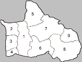
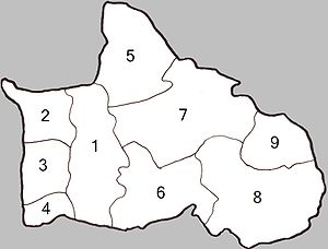
The district is subdivided into 9 subdistricts (tambonTambon
Tambon is a local government unit in Thailand. Below district and province , they form the third administrative subdivision level. As of the 2009 there are 7255 tambon, not including the 169 khwaeng of Bangkok, which are set at the same administrative level, thus every district contains 8-10 tambon...
), which are further subdivided into 87 muban
Muban
Muban is the lowest administrative subdivision of Thailand. Usually translated as village, they are the subdivision of tambon. As of 2008, there are 74944 administrative villages in Thailand. As of the 1990 census, the average village consisted of 144 households or 746 persons.A muban does not...
, which are divisions at the village level. Many villages occupy more than one muban. There are two subdistrict municipalities (thesaban tambon) - Bang Krathum covering parts of the tambon Bang Krathum, and Noen Kum which covers the complete tambon Noen Kum and Wat Ta Yom. There are further 7 Tambon administrative organizations (TAO).
| No. | Name | Thai | Villages | Inh. Population A population is all the organisms that both belong to the same group or species and live in the same geographical area. The area that is used to define a sexual population is such that inter-breeding is possible between any pair within the area and more probable than cross-breeding with individuals... |
|---|---|---|---|---|
| 1. | Bang Krathum Bang Krathum Bang Krathum is a subdistrict in the Bang Krathum district of Phitsanulok Province, Thailand.-Etymology:The first element bang means village or settlement. The second element krathum means bur-flower tree .-Geography:Bang Krathum's topography consists of flat, fertile lowlands... |
บางกระทุ่ม | 9 | 6,823 |
| 2. | Ban Rai Ban Rai Ban Rai is a subdistrict in the Bang Krathum district of Phitsanulok Province, Thailand.-Geography:Ban Rai borders Amphoe Bang Rakam and Wang Nam Khu of Amphoe Mueang Phitsanulok to the north, Bang Krathum to the east, Khok Salut to the south and Phichit Province to the west.Most of Ban Rai lies... |
บ้านไร่ | 10 | 4,558 |
| 3. | Khok Salut Khok Salut Khok Salut is a subdistrict in the Bang Krathum district of Phitsanulok Province, Thailand.-Geography:Khok Salut is bounded to the north by Ban Rai, to the east by Bang Krathum, to the south by Sanam Khli and to the west by Phichit Province.... |
โคกสลุด | 10 | 3,265 |
| 4. | Sanam Khli Sanam Khli Sanam Khli is a subdistrict in the Bang Krathum district of Phitsanulok Province , Thailand.-Geography:Sanam Khli borders Khok Salut to the north, Bang Krathum to the east, and Phichit Province to the south and west.... |
สนามคลี | 6 | 2,519 |
| 5. | Tha Tan Tha Tan Tha Tan is a subdistrict in the Bang Krathum district of Phitsanulok Province, Thailand.-Geography:Tha Tan is the northernmost subdistrict in Bang Krathum, bordering Wang Nam Khu of Amphoe Mueang Phitsanulok to the northwest, Amphoe Wang Thong to the northeast, Nakhon Pa Mak to the south and Bang... |
ท่าตาล | 9 | 6,868 |
| 6. | Phai Lom Phai Lom Phai Lom is a subdistrict in the Bang Krathum district of Phitsanulok Province, Thailand.-Geography:Phai Lom borders Nakhon Pa Mak to the north, Noen Kum to the east, Phichit Province to the south and Bang Krathum to the west.... |
ไผ่ล้อม | 11 | 4,681 |
| 7. | Nakhon Pa Mak Nakhon Pa Mak Nakhon Pa Mak is a rural subdistrict in the Bang Krathum district of Phitsanulok Province, Thailand.-Etymology:The first element nakhon means town or city. The second element pa means forest. The third element mak means betel palm... |
นครป่าหมาก | 13 | 6,472 |
| 8. | Noen Kum Noen Kum Noen Kum is a subdistrict in the Bang Krathum district of Phitsanulok Province, Thailand.-Geography:Noen Kum borders Wat Ta Yom to the north, Amphoe Wang Thong to the northeast, Phichit Province to the south and southeast, Phai Lom to the west and Nakhon Pa Mak to the northwest.Noen Kum lies... |
เนินกุ่ม | 11 | 8,968 |
| 9. | Wat Ta Yom Wat Ta Yom Wat Ta Yom is a subdistrict in the Bang Krathum district of Phitsanulok Province, Thailand.-Etymology:The first element wat means temple; the second element ta means eye; the third element yom means weep, hence Weeping Eye Temple.-Geography:Wat Ta Yom is bordered to the north by Nong Phra in... |
วัดตายม | 8 | 4,513 |
Economy
Bang Krathum's chief crops are riceRice
Rice is the seed of the monocot plants Oryza sativa or Oryza glaberrima . As a cereal grain, it is the most important staple food for a large part of the world's human population, especially in East Asia, Southeast Asia, South Asia, the Middle East, and the West Indies...
, sugar cane, fruits, oranges
Orange (fruit)
An orange—specifically, the sweet orange—is the citrus Citrus × sinensis and its fruit. It is the most commonly grown tree fruit in the world....
, tamarind
Tamarind
Tamarind is a tree in the family Fabaceae. The genus Tamarindus is monotypic .-Origin:...
s, cassava
Cassava
Cassava , also called yuca or manioc, a woody shrub of the Euphorbiaceae native to South America, is extensively cultivated as an annual crop in tropical and subtropical regions for its edible starchy tuberous root, a major source of carbohydrates...
s, soy beans and mung bean
Mung bean
The mung bean is the seed of Vigna radiata. It is native to the Indian subcontinent.-Description:They are small, ovoid in shape, and green in color...
s.
In Bang Krathum, there are a number of "banana factories" that package an assortment of dried fruits including dried bananas and tamarinds that are sold within Thailand and exported throughout the world. There is also a rather large sugar cane production plant in the district owned by Phitsanulok Sugar Co., Ltd.
Settlements
Of the 51 villages that comprise Bang Krathum District, those significant in size as to occupy multiple muban are as follows:- Ban Bang KrathumBan Bang KrathumBan Bang Krathum is a town in the Bang Krathum Subdistrict of Bang Krathum District of Phitsanulok Province, Thailand.-Etymology:The first element ban means village.The second element bang means village or settlement...
- Ban Dong Mee
- Ban Grong GrengBan Grong GrengBan Grong Greng is a rural village in the northwest portion of the Nakhon Pa Mak subdistrict of Bang Krathum District of Phitsanulok Province, Thailand.-Etymology:The first element ban means village....
- Ban Khok Salut
- Ban Khok Sanam
- Ban Noen Kum
- Ban Sam RuenBan Sam RuenBan Sam Ruen is a village in the Nakhon Pa Mak subdistrict of Amphoe Bang Krathum District of Phitsanulok Province, Thailand.-Etymology:The first element ban means village. The second element sam means three...
- Ban Sanam Khli
- Ban Tha Makam
- Ban Tha Na
- Ban Tha Tan
- Ban Wat Kwang
- Ban Wat Ta Yom
- Ban Yan Yao
Temples
There are 44 TheravadaTheravada
Theravada ; literally, "the Teaching of the Elders" or "the Ancient Teaching", is the oldest surviving Buddhist school. It was founded in India...
Buddhist temples in the district. At least one, Wat Grung See Jayrin
Ban Grong Greng
Ban Grong Greng is a rural village in the northwest portion of the Nakhon Pa Mak subdistrict of Bang Krathum District of Phitsanulok Province, Thailand.-Etymology:The first element ban means village....
, has a historic chedi.
Flooding
In 2006, there were reported cases of leptospirosisLeptospirosis
Leptospirosis is caused by infection with bacteria of the genus Leptospira, and affects humans as well as other mammals, birds, amphibians, and reptiles.The...
among residents of Bang Krathum, contracted due to the amount of standing water.