

Alberta Township System
Encyclopedia
The Alberta Township System (ATS) is a land surveying
system used in the Canadian
province
of Alberta
and other parts of western Canada
.
(DLS) system as implemented in Canada
. In fact, the implementation in western Canada reflects a number of slightly different approaches, as well as a large number of errors.
Long before the Dominion Land Surveyor (DLS) first came into official existence in 1872, licensed surveyors known as Provincial Land Surveyors had been functioning in the Provinces of Ontario
and Quebec
(then called Canada West and Canada East) under an Act of 1849. Establishing a system of examination for new aspirants to the title of “Dominion Land Surveyor” was officially adopted in 1874. In 1910 The Alberta Surveyors Act prescribed the system and the methods whereby land surveys were to be carried out under the general purview of a provincial Director of Surveys whose responsibility it was to see that all survey work was performed in accordance with the provisions of that Act.
The system is also used by provincial governments when selling exploration rights, and oil and gas wells are referenced by their location as defined within the Alberta Township System.
 Below is a brief description of how to lay out the DLS
grid for Alberta
.
Lay off 6.0375 miles (9.7 km) ticks from the 49th parallel
of latitude to the 60th parallel
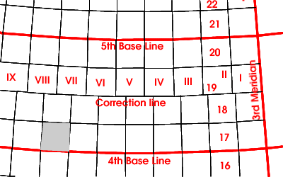
. This gives 127 township
lines.
The 49th parallel of latitude
is the first base line of the ATS system. On it lay off 6.075 miles (9.8 km) ticks westwards starting at the 110th line
of longitude
(4th DLS meridian). Start over at the 114th
and 118th
lines of longitude (5th and 6th DLS meridians). Extend these ticks 12.075 miles (19.4 km) due north (following a line of constant longitude) to the first correction line. This gets you your first set of range lines.
Starting at the 49th parallel (first base line) go 24.15 miles (38.9 km) directly north. This gets you to the second base line. At the latitude corresponding to this distance from the 49th parallel lay off 6.075 miles (9.8 km) ticks westwards from 110th meridian
as you did at the 1st base line. The circumference of the earth has decreased as you went northwards, so there will be fewer full ticks than there were one base line south. Extend 12.075 miles (19.4 km) north and 12.075 miles (19.4 km) south from these ticks. This gets you your next set of range lines. You will note there is an offset between the range lines extending north from the lower base line and those extending south from the current ones. This offset occurs along what is called a correction line.
Repeat the base line process every 24.15 miles (38.9 km) northwards (to the 32nd).
All this will result in a mesh of cells nominally six miles (plus 3 or 6 chain
s for road allowances) on a side. Each such cell is called a township (not to be confused with the township lines laid off earlier). Subdivide the township into 36 sections by laying off ticks of one-sixth of each township side and connecting them by north-south and east-west lines. The sections are numbered sinusoidally starting from the southeast corner of the township.
Sections can be similarly subdivided into quarters by placing and connecting ticks at the halfway point on each section side. Use the same process to subdivide sections into legal subdivisions (LSD) except place the tick at the one-quarter waypoints. LSDs are numbered sinusoidally starting at the southeast corner of the section.
While the ATS format is still proprietary
, online conversion tools have been developed.
Surveying
See Also: Public Land Survey SystemSurveying or land surveying is the technique, profession, and science of accurately determining the terrestrial or three-dimensional position of points and the distances and angles between them...
system used in the Canadian
Canada
Canada is a North American country consisting of ten provinces and three territories. Located in the northern part of the continent, it extends from the Atlantic Ocean in the east to the Pacific Ocean in the west, and northward into the Arctic Ocean...
province
Provinces and territories of Canada
The provinces and territories of Canada combine to make up the world's second-largest country by area. There are ten provinces and three territories...
of Alberta
Alberta
Alberta is a province of Canada. It had an estimated population of 3.7 million in 2010 making it the most populous of Canada's three prairie provinces...
and other parts of western Canada
Western Canada
Western Canada, also referred to as the Western provinces and commonly as the West, is a region of Canada that includes the four provinces west of the province of Ontario.- Provinces :...
.
History and background
In principle there is a mathematical basis for the Alberta Township System (ATS) variant of the Dominion Land SurveyDominion Land Survey
The Dominion Land Survey is the method used to divide most of Western Canada into one-square-mile sections for agricultural and other purposes. It is based on the layout of the Public Land Survey System used in the United States, but has several differences...
(DLS) system as implemented in Canada
Canada
Canada is a North American country consisting of ten provinces and three territories. Located in the northern part of the continent, it extends from the Atlantic Ocean in the east to the Pacific Ocean in the west, and northward into the Arctic Ocean...
. In fact, the implementation in western Canada reflects a number of slightly different approaches, as well as a large number of errors.
Long before the Dominion Land Surveyor (DLS) first came into official existence in 1872, licensed surveyors known as Provincial Land Surveyors had been functioning in the Provinces of Ontario
Ontario
Ontario is a province of Canada, located in east-central Canada. It is Canada's most populous province and second largest in total area. It is home to the nation's most populous city, Toronto, and the nation's capital, Ottawa....
and Quebec
Quebec
Quebec or is a province in east-central Canada. It is the only Canadian province with a predominantly French-speaking population and the only one whose sole official language is French at the provincial level....
(then called Canada West and Canada East) under an Act of 1849. Establishing a system of examination for new aspirants to the title of “Dominion Land Surveyor” was officially adopted in 1874. In 1910 The Alberta Surveyors Act prescribed the system and the methods whereby land surveys were to be carried out under the general purview of a provincial Director of Surveys whose responsibility it was to see that all survey work was performed in accordance with the provisions of that Act.
The system is also used by provincial governments when selling exploration rights, and oil and gas wells are referenced by their location as defined within the Alberta Township System.
How it works
Dominion Land Survey
The Dominion Land Survey is the method used to divide most of Western Canada into one-square-mile sections for agricultural and other purposes. It is based on the layout of the Public Land Survey System used in the United States, but has several differences...
grid for Alberta
Alberta
Alberta is a province of Canada. It had an estimated population of 3.7 million in 2010 making it the most populous of Canada's three prairie provinces...
.
Lay off 6.0375 miles (9.7 km) ticks from the 49th parallel
49th parallel north
The 49th parallel north is a circle of latitude that is 49 degrees north of the Earth's equatorial plane. It crosses Europe, Asia, the Pacific Ocean, North America, and the Atlantic Ocean....
of latitude to the 60th parallel
60th parallel north
The 60th parallel north is a circle of latitude that is 60 degrees north of the Earth's equatorial plane. It crosses Europe, Asia, the Pacific Ocean, North America, and the Atlantic Ocean....
. This gives 127 township
Township
The word township is used to refer to different kinds of settlements in different countries. Township is generally associated with an urban area. However there are many exceptions to this rule. In Australia, the United States, and Canada, they may be settlements too small to be considered urban...
lines.
The 49th parallel of latitude
Latitude
In geography, the latitude of a location on the Earth is the angular distance of that location south or north of the Equator. The latitude is an angle, and is usually measured in degrees . The equator has a latitude of 0°, the North pole has a latitude of 90° north , and the South pole has a...
is the first base line of the ATS system. On it lay off 6.075 miles (9.8 km) ticks westwards starting at the 110th line
110th meridian west
The meridian 110° west of Greenwich is a line of longitude that extends from the North Pole across the Arctic Ocean, North America, the Pacific Ocean, the Southern Ocean, and Antarctica to the South Pole....
of longitude
Longitude
Longitude is a geographic coordinate that specifies the east-west position of a point on the Earth's surface. It is an angular measurement, usually expressed in degrees, minutes and seconds, and denoted by the Greek letter lambda ....
(4th DLS meridian). Start over at the 114th
114th meridian west
The meridian 114° west of Greenwich is a line of longitude that extends from the North Pole across the Arctic Ocean, North America, the Pacific Ocean, the Southern Ocean, and Antarctica to the South Pole....
and 118th
118th meridian west
The meridian 118° west of Greenwich is a line of longitude that extends from the North Pole across the Arctic Ocean, North America, the Pacific Ocean, the Southern Ocean, and Antarctica to the South Pole....
lines of longitude (5th and 6th DLS meridians). Extend these ticks 12.075 miles (19.4 km) due north (following a line of constant longitude) to the first correction line. This gets you your first set of range lines.
Starting at the 49th parallel (first base line) go 24.15 miles (38.9 km) directly north. This gets you to the second base line. At the latitude corresponding to this distance from the 49th parallel lay off 6.075 miles (9.8 km) ticks westwards from 110th meridian
Meridian (geography)
A meridian is an imaginary line on the Earth's surface from the North Pole to the South Pole that connects all locations along it with a given longitude. The position of a point along the meridian is given by its latitude. Each meridian is perpendicular to all circles of latitude...
as you did at the 1st base line. The circumference of the earth has decreased as you went northwards, so there will be fewer full ticks than there were one base line south. Extend 12.075 miles (19.4 km) north and 12.075 miles (19.4 km) south from these ticks. This gets you your next set of range lines. You will note there is an offset between the range lines extending north from the lower base line and those extending south from the current ones. This offset occurs along what is called a correction line.
Repeat the base line process every 24.15 miles (38.9 km) northwards (to the 32nd).
All this will result in a mesh of cells nominally six miles (plus 3 or 6 chain
Chain (unit)
A chain is a unit of length; it measures 66 feet or 22 yards or 100 links . There are 10 chains in a furlong, and 80 chains in one statute mile. An acre is the area of 10 square chains...
s for road allowances) on a side. Each such cell is called a township (not to be confused with the township lines laid off earlier). Subdivide the township into 36 sections by laying off ticks of one-sixth of each township side and connecting them by north-south and east-west lines. The sections are numbered sinusoidally starting from the southeast corner of the township.
Sections can be similarly subdivided into quarters by placing and connecting ticks at the halfway point on each section side. Use the same process to subdivide sections into legal subdivisions (LSD) except place the tick at the one-quarter waypoints. LSDs are numbered sinusoidally starting at the southeast corner of the section.
While the ATS format is still proprietary
Property
Property is any physical or intangible entity that is owned by a person or jointly by a group of people or a legal entity like a corporation...
, online conversion tools have been developed.
- Alberta Geological Survey converts the system to geographical coordinates
External links
- LSD + GPS + UTM coordinates (batch) conversion Free map convertors & tools
- Map converters by Alberta Geological Survey