

Alamo, California
Encyclopedia
Alamo is an unincorporated community and census-designated place
(CDP) in Contra Costa County
, California
, in the United States
. It is located in the East Bay
region of the San Francisco Bay Area
. As of the 2010 census
, the population was 14,750.
Alamo was named by the Spanish in 1850 for the poplar trees that lined San Ramon Creek.
As an unincorporated community, Alamo does not have a government of its own. Police services are provided by the Contra Costa County Office of the Sheriff. Fire and EMS
services are provided by the San Ramon Valley Fire Protection District
.
In August, 2007, a group of citizens launched a new initiative to incorporate the community, the latest in a series of attempts that go back to the early 1960s or before.http://www.alamoinc.org/ Previous failed Alamo incorporation efforts always included parts of other nearby unincorporated areas: Alamo-Danville (1964)http://www.museumsrv.org/srvm_History_HomeRuleII.html and Alamo-Danville-San Ramon (1976). http://www.museumsrv.org/srvm_History_HomeRuleII.html http://www.museumsrv.org/srvm_history_HomeRuleIII.html
The latest Alamo incorporation came to a vote on March 3, 2009 when the measure was defeated.http://www.danvilleweekly.com/story.php?story_id=5718
In 1985, Alamo almost had a chance to vote on its own incorporation, but Contra Costa County turned down the effort. Alamo has never had an opportunity to vote on incorporation by itself. http://www.yourmonthlypaper.com/pdfs/AT/2007/AT2007.Oct.full.pdf
tribe closely connected to the Saclans of Walnut Creek
, lived in Alamo in the eighteenth century.
After Mission San José was founded in 1797, its grazing area stretched throughout the San Ramon Valley
. The Mexican land grant Rancho San Ramon
was deeded to Mariano Castro and his uncle Bartolo Pacheco in 1833. It covered today's Danville
and Alamo. Castro owned the northern half, which included Alamo.
In 1843 much of the Alamo, Las Trampas and Tice Valley areas were granted to brothers Inocencio and Jose Romero. It was called Rancho El Sobrante de San Ramon. Because of missing title papers, the brothers lost their ranch in American courts in 1857.
Pioneers Mary Ann and John Jones traveled through Alamo in 1847. she provided the earliest English description of the area in her diary. Her husband stopped the wagon saying, "Mary, look! Did you ever see anything so beautiful?" She wrote later:
The Jones family returned to Alamo in 1851, after California had become a state. John became the first postmaster in 1852 and she applied her considerable energies to schooling children and beginning a Cumberland Presbyterian church. Other early Alamo founders included David Glass, George Engelmeyer, Silas and Susanna Stone, Captain Wall, Joshua Bollinger, and James Foster.
The area was named Alamo, which means "poplar" or "cottonwood" in Spanish. Because of its location and fine weather, Alamo grew quickly. An early road from the redwoods near Moraga ran through Tice Valley to Alamo, since Americans preferred redwood for building materials instead of Mexican adobe brick.
The Hemme, Bollinger, Jones and Stone ranches began by grazing cattle and raising wheat and other grains. In 1891 the Hemme train station was placed near today's Hemme Avenue; later it was re-named the Alamo station.
Eventually orchards and vineyards spread across the area. Almonds, walnuts, pears, grapes and other fruit thrived in the mild climate. In 1873, Alamo pioneer Myron Hall grafted Persian cuttings to native walnut
trees and helped start the prosperous walnut industry in Contra Costa County. This "mother tree" was tended for over 100 years.
The Alamo post office is the oldest continuously operated one in the valley. It was always an important community gathering place. According to longtime postmaster Bertha Linhares, when the mail was expected the men
Her father, brother and sister were also postmasters from 1905 to 1960.
On September 5, 2008, a 4.0 earthquake occurred in the area of Round Hill North.
, an Alamo air watch tower was built by the community. Volunteers watched for Japan
ese war planes round the clock from 1942 to 1945. San Ramon Valley's population totaled 2,126 at that time.
The Alamo Improvement Association (AIA) began in 1953. For 50 years its purpose has been to advance and improve the welfare of properties in Alamo and to preserve the established character of Alamo as an agricultural and semi-rural residential area.
After the war, hundreds and then thousands of new people arrived. Round Hill Country Club opened in 1960 on land that had belonged to the Mott sisters and Grover Squire. In 1964, Interstate 680
was completed through San Ramon Valley, which encouraged even more growth.
Rapid valley growth fueled controversies. In the mid-'60s, one controversy focused on the philosophy of a new, visionary superintendent of the San Ramon Unified School District, Richard L. Foster. The Superintendent of the Alamo School District, John "Jock" Waugh, strongly supported Richard Foster and his visionary educational philosophy. Also, debates about the pace of development led to several votes on cityhood, spearheaded by residents who wanted more local control. An Alamo-Danville incorporation election in 1964 lost 2,086 to 1,958 with "loss of identity for Alamo" a main concern.
Today Alamo is an enclave of green with many homes on lots of 0.5 acres (2,023.4 m²) between Walnut Creek and Danville. Its population in 2000 was 15,626. It is governed by the County Board of Supervisors, with the AIA and several active county service areas advising on police, landscape and park issues.
St. Louis Cardinals
manager Tony La Russa
resides in Alamo.
Olympic
gold medalist Kristi Yamaguchi
resides in Alamo.
Denver Broncos
Kansas City Chiefs
Carolina Panthers
ex NFL player Greg Kragen
resides in Alamo
Safeway Inc.
supermarket president and CEO Steven Burd
resides in Alamo
Former Metallica
bassist Jason Newsted
resides in Alamo
 Alamo is located in Contra Costa County
. Adjoining towns and cities are Walnut Creek
to the north, Danville
, Dublin
, and San Ramon
to the south, and Diablo
plus Blackhawk
to the southeast.
Interstate 680
serves as the main means of transport out of the town.
According to the United States Census Bureau
, the CDP has a total area of 9.7 square miles (25.1 km²), all of it land.
Livorna Park is at the corner of Livorna Road & Miranda Avenue. It features a large open-air gazebo, a sand volleyball court, a multi-use sports court, playground structures, large play areas, drinking fountain, restrooms and off-street parking.
Alamo School Sports Field located at 100 Wilson Road offers soccer and baseball fields, batting cages, and a picnic and barbecue
area.
Hap Magee Ranch Park is on the Alamo-Danville Border on La Gonda Way. This park has several historic structures. There are picnic facilities, children's water play area, a large meadow with a spectacular heritage oak, dog parks and off-street parking. The park sits near the intersection of the Iron Horse Trail and the Las Trampas to Mt. Diablo Regional Trail.
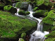
Las Trampas Regional Wilderness is a 5342 acres (21.6 km²) park located to the immediate southwest of the town. The wilderness contains numerous plant and animal communities, including forested hillsides and riparian woods. The park is also host to several secluded waterfalls, many of which are difficult to reach.
runs through Alamo releasing small tremors about every other month. The fault line has never had a history of being dangerous. However, the Hayward Fault, a close neighbor, is extremely active.
was 1,507.2 people per square mile (581.9/km²). The racial makeup of Alamo was 12,662 (86.9%) White, 1,190 (8.2%) Asian, Hispanic or Latino of any race were 839 persons (5.8%), 479 (3.3%) from two or more races, 126 (0.9%) from other races
, 73 (0.5%) African American, 22 (0.2%) Pacific Islander and 18 (0.1%) Native American.
The Census reported that 14,539 people (99.8% of the population) lived in households, 22 (0.2%) lived in non-institutionalized group quarters, and 9 (0.1%) were institutionalized.
There were 5,152 households, out of which 1,921 (37.3%) had children under the age of 18 living in them, 3,982 (77.3%) were opposite-sex married couples
living together, 274 (5.3%) had a female householder with no husband present, 141 (2.7%) had a male householder with no wife present. There were 111 (2.2%) unmarried opposite-sex partnerships
, and 43 (0.8%) same-sex married couples or partnerships. 598 households (11.6%) were made up of individuals and 341 (6.6%) had someone living alone who was 65 years of age or older. The average household size was 2.82. There were 4,397 families
(85.3% of all households); the average family size was 3.05.
The population was spread out with 3,739 people (25.7%) under the age of 18, 695 people (4.8%) aged 18 to 24, 2,095 people (14.4%) aged 25 to 44, 5,470 people (37.5%) aged 45 to 64, and 2,571 people (17.6%) who were 65 years of age or older. The median age was 47.7 years. For every 100 females there were 98.6 males. For every 100 females age 18 and over, there were 94.9 males.
There were 5,378 housing units at an average density of 556.3 per square mile (214.8/km²), of which 4,709 (91.4%) were owner-occupied, and 443 (8.6%) were occupied by renters. The homeowner vacancy rate was 1.2%; the rental vacancy rate was 6.5%. 13,340 people (91.6% of the population) lived in owner-occupied housing units and 1,199 people (8.2%) lived in rental housing units.
of 2000, there were 15,626 people, 5,406 households, and 4,573 families residing in the CDP. The population density
was 759.5 people per square mile (293.3/km²). There were 5,497 housing units at an average density of 267.2/sq mi (103.2/km²). The racial makeup of the CDP was 90.36% White
, 0.47% Black
or African American
, 0.22% Native American
, 6.10% Asian
, 0.12% Pacific Islander
, 0.64% from other races
, and 2.21% from two or more races. 3.94% of the population were Hispanic
or Latino
of any race.
There were 5,406 households out of which 40.1% had children under the age of 18 living with them, 78.1% were married couples
living together, 4.4% had a female householder with no husband present, and 15.4% were non-families. 11.5% of all households were made up of individuals and 5.2% had someone living alone who was 65 years of age or older. The average household size was 2.87 and the average family size was 3.10.
In the CDP the population was spread out with 27.6% under the age of 18, 3.9% from 18 to 24, 21.9% from 25 to 44, 34.4% from 45 to 64, and 12.2% who were 65 years of age or older. The median age was 43 years. For every 100 females there were 98.5 males. For every 100 females age 18 and over, there were 94.3 males.
The median income for a household in the CDP was $137,105, and the median income for a family was $147,643. Males had a median income of $100,000 versus $59,205 for females. The per capita income
for the CDP was $65,705. About 2.6% of families and 3.8% of the population were below the poverty line, including 5.2% of those under age 18 and 5.3% of those age 65 or over.
ESRI lists more recent statistics (2006).
The racial makeup of Alamo is listed as 87.7% White, 0.6% Black, 0.2% American Indian, 7.7% Asian or Pacific Islander, 0.8% Other. 3.0% were two or more races, with 5.4% being of Hispanic origin.
The Median Household Income was listed as $169,918 and the average home value was listed as $1,163,436.
Source ESRI Business Analyst Online
Census-designated place
A census-designated place is a concentration of population identified by the United States Census Bureau for statistical purposes. CDPs are delineated for each decennial census as the statistical counterparts of incorporated places such as cities, towns and villages...
(CDP) in Contra Costa County
Contra Costa County, California
Contra Costa County is a primarily suburban county in the San Francisco Bay Area of the U.S. state of California. As of the 2010 census, it had a population of 1,049,025...
, California
California
California is a state located on the West Coast of the United States. It is by far the most populous U.S. state, and the third-largest by land area...
, in the United States
United States
The United States of America is a federal constitutional republic comprising fifty states and a federal district...
. It is located in the East Bay
East Bay (San Francisco Bay Area)
The East Bay is a commonly used, informal term for the lands on the eastern side of the San Francisco Bay, in the San Francisco Bay Area, in California, United States...
region of the San Francisco Bay Area
San Francisco Bay Area
The San Francisco Bay Area, commonly known as the Bay Area, is a populated region that surrounds the San Francisco and San Pablo estuaries in Northern California. The region encompasses metropolitan areas of San Francisco, Oakland, and San Jose, along with smaller urban and rural areas...
. As of the 2010 census
United States Census, 2010
The Twenty-third United States Census, known as Census 2010 or the 2010 Census, is the current national census of the United States. National Census Day was April 1, 2010 and is the reference date used in enumerating individuals...
, the population was 14,750.
Alamo was named by the Spanish in 1850 for the poplar trees that lined San Ramon Creek.
As an unincorporated community, Alamo does not have a government of its own. Police services are provided by the Contra Costa County Office of the Sheriff. Fire and EMS
Emergency medical services
Emergency medical services are a type of emergency service dedicated to providing out-of-hospital acute medical care and/or transport to definitive care, to patients with illnesses and injuries which the patient, or the medical practitioner, believes constitutes a medical emergency...
services are provided by the San Ramon Valley Fire Protection District
San Ramon Valley Fire Protection District
The San Ramon Valley Fire Protection District is an autonomous Special District as defined under the Fire Protection District Law of 1987, California Health and Safety Code, Section 13800...
.
In August, 2007, a group of citizens launched a new initiative to incorporate the community, the latest in a series of attempts that go back to the early 1960s or before.http://www.alamoinc.org/ Previous failed Alamo incorporation efforts always included parts of other nearby unincorporated areas: Alamo-Danville (1964)http://www.museumsrv.org/srvm_History_HomeRuleII.html and Alamo-Danville-San Ramon (1976). http://www.museumsrv.org/srvm_History_HomeRuleII.html http://www.museumsrv.org/srvm_history_HomeRuleIII.html
The latest Alamo incorporation came to a vote on March 3, 2009 when the measure was defeated.http://www.danvilleweekly.com/story.php?story_id=5718
In 1985, Alamo almost had a chance to vote on its own incorporation, but Contra Costa County turned down the effort. Alamo has never had an opportunity to vote on incorporation by itself. http://www.yourmonthlypaper.com/pdfs/AT/2007/AT2007.Oct.full.pdf
History
People have lived in this area for over 5,000 years. The Tatcan Indians, a Bay MiwokBay Miwok
The Bay Miwok were a cultural and linguistic group of Miwok, a Native American people in Northern California who lived in Contra Costa County. They joined the Franciscan mission system during the early nineteenth century, suffered a devastating population decline, and lost their language as they...
tribe closely connected to the Saclans of Walnut Creek
Walnut Creek, California
Walnut Creek is an incorporated city located east of the city of Oakland. It lies in the East Bay region of the San Francisco Bay Area. While not as large as neighboring Concord, Walnut Creek serves as the business and entertainment hub for the neighboring cities within central Contra Costa...
, lived in Alamo in the eighteenth century.
After Mission San José was founded in 1797, its grazing area stretched throughout the San Ramon Valley
San Ramon Valley
The San Ramon Valley is a region in Contra Costa County and Alameda County, California, east of Oakland. The cities of San Ramon, Danville and Alamo as well as the southern edge of Walnut Creek are located in the valley. Interstate 680 serves as the primary transportation route for the...
. The Mexican land grant Rancho San Ramon
Rancho San Ramon (Pacheco-Castro)
Rancho San Ramon was a Mexican land grant in present day Contra Costa County, California given in 1833 by Governor Jose Figueroa to Mariano Castro and Bartolome Pacheco. Governor Figueroa granted Castro and Pacheco two square leagues of San Ramon Valley from the crest of the western ridge to the...
was deeded to Mariano Castro and his uncle Bartolo Pacheco in 1833. It covered today's Danville
Danville, California
The Town of Danville is located in the San Ramon Valley in Contra Costa County, California. It is one of the incorporated municipalities in California that uses "town" in its name instead of "city". The population was 42,039 in 2010. Danville is one of the wealthiest suburbs of Oakland and San...
and Alamo. Castro owned the northern half, which included Alamo.
In 1843 much of the Alamo, Las Trampas and Tice Valley areas were granted to brothers Inocencio and Jose Romero. It was called Rancho El Sobrante de San Ramon. Because of missing title papers, the brothers lost their ranch in American courts in 1857.
Pioneers Mary Ann and John Jones traveled through Alamo in 1847. she provided the earliest English description of the area in her diary. Her husband stopped the wagon saying, "Mary, look! Did you ever see anything so beautiful?" She wrote later:
On every side, the valley and surrounding hills were covered with thick, velvety clover, and with wild oats standing waist high waving and rippling in the summer breeze, like the bosom of a lake.
The Jones family returned to Alamo in 1851, after California had become a state. John became the first postmaster in 1852 and she applied her considerable energies to schooling children and beginning a Cumberland Presbyterian church. Other early Alamo founders included David Glass, George Engelmeyer, Silas and Susanna Stone, Captain Wall, Joshua Bollinger, and James Foster.
The area was named Alamo, which means "poplar" or "cottonwood" in Spanish. Because of its location and fine weather, Alamo grew quickly. An early road from the redwoods near Moraga ran through Tice Valley to Alamo, since Americans preferred redwood for building materials instead of Mexican adobe brick.
The Hemme, Bollinger, Jones and Stone ranches began by grazing cattle and raising wheat and other grains. In 1891 the Hemme train station was placed near today's Hemme Avenue; later it was re-named the Alamo station.
Eventually orchards and vineyards spread across the area. Almonds, walnuts, pears, grapes and other fruit thrived in the mild climate. In 1873, Alamo pioneer Myron Hall grafted Persian cuttings to native walnut
Walnut
Juglans is a plant genus of the family Juglandaceae, the seeds of which are known as walnuts. They are deciduous trees, 10–40 meters tall , with pinnate leaves 200–900 millimetres long , with 5–25 leaflets; the shoots have chambered pith, a character shared with the wingnuts , but not the hickories...
trees and helped start the prosperous walnut industry in Contra Costa County. This "mother tree" was tended for over 100 years.
The Alamo post office is the oldest continuously operated one in the valley. It was always an important community gathering place. According to longtime postmaster Bertha Linhares, when the mail was expected the men
sat in the post office-store in the winter … the women went into our sitting room and visited with my mother … We always heard all the news and troubles of the Alamo residents.
Her father, brother and sister were also postmasters from 1905 to 1960.
On September 5, 2008, a 4.0 earthquake occurred in the area of Round Hill North.
Alamo in modern times
During World War IIWorld War II
World War II, or the Second World War , was a global conflict lasting from 1939 to 1945, involving most of the world's nations—including all of the great powers—eventually forming two opposing military alliances: the Allies and the Axis...
, an Alamo air watch tower was built by the community. Volunteers watched for Japan
Japan
Japan is an island nation in East Asia. Located in the Pacific Ocean, it lies to the east of the Sea of Japan, China, North Korea, South Korea and Russia, stretching from the Sea of Okhotsk in the north to the East China Sea and Taiwan in the south...
ese war planes round the clock from 1942 to 1945. San Ramon Valley's population totaled 2,126 at that time.
The Alamo Improvement Association (AIA) began in 1953. For 50 years its purpose has been to advance and improve the welfare of properties in Alamo and to preserve the established character of Alamo as an agricultural and semi-rural residential area.
After the war, hundreds and then thousands of new people arrived. Round Hill Country Club opened in 1960 on land that had belonged to the Mott sisters and Grover Squire. In 1964, Interstate 680
Interstate 680 (California)
Interstate 680 is a north–south Interstate Highway in Northern California. It curves around the eastern cities of the San Francisco Bay Area from San Jose to Interstate 80 at Cordelia, bypassing cities along the eastern shore of San Francisco Bay such as Oakland and Richmond while serving...
was completed through San Ramon Valley, which encouraged even more growth.
Rapid valley growth fueled controversies. In the mid-'60s, one controversy focused on the philosophy of a new, visionary superintendent of the San Ramon Unified School District, Richard L. Foster. The Superintendent of the Alamo School District, John "Jock" Waugh, strongly supported Richard Foster and his visionary educational philosophy. Also, debates about the pace of development led to several votes on cityhood, spearheaded by residents who wanted more local control. An Alamo-Danville incorporation election in 1964 lost 2,086 to 1,958 with "loss of identity for Alamo" a main concern.
Today Alamo is an enclave of green with many homes on lots of 0.5 acres (2,023.4 m²) between Walnut Creek and Danville. Its population in 2000 was 15,626. It is governed by the County Board of Supervisors, with the AIA and several active county service areas advising on police, landscape and park issues.
St. Louis Cardinals
St. Louis Cardinals
The St. Louis Cardinals are a professional baseball team based in St. Louis, Missouri. They are members of the Central Division in the National League of Major League Baseball. The Cardinals have won eleven World Series championships, the most of any National League team, and second overall only to...
manager Tony La Russa
Tony La Russa
Anthony "Tony" La Russa, Jr. is a former Major League Baseball manager and infielder, best known for his tenures as manager of the Chicago White Sox, Oakland Athletics, and St. Louis Cardinals...
resides in Alamo.
Olympic
Olympic Games
The Olympic Games is a major international event featuring summer and winter sports, in which thousands of athletes participate in a variety of competitions. The Olympic Games have come to be regarded as the world’s foremost sports competition where more than 200 nations participate...
gold medalist Kristi Yamaguchi
Kristi Yamaguchi
Kristine Tsuya "Kristi" Yamaguchi-Hedican is an American figure skater. She is the 1992 Olympic Champion in ladies' singles. Yamaguchi also won two World Figure Skating Championships in 1991 and 1992 and a U.S. Figure Skating Championships in 1992. She won one junior world title in 1988 and two...
resides in Alamo.
Denver Broncos
Denver Broncos
The Denver Broncos are a professional American football team based in Denver, Colorado. They are currently members of the West Division of the American Football Conference in the National Football League...
Kansas City Chiefs
Kansas City Chiefs
The Kansas City Chiefs are a professional American football team based in Kansas City, Missouri. They are a member of the Western Division of the American Football Conference in the National Football League . Originally named the Dallas Texans, the club was founded by Lamar Hunt in 1960 as a...
Carolina Panthers
Carolina Panthers
The Carolina Panthers are a professional American football team based in Charlotte, North Carolina. They are currently members of the South Division of the National Football Conference in the National Football League . The Panthers, along with the Jacksonville Jaguars, joined the NFL as expansion...
ex NFL player Greg Kragen
Greg Kragen
Gregory John Kragen is a former American football defensive lineman in the National Football League including three Super Bowls and five championship games. He was selected for the Pro Bowl in 1989 and made the All-Madden team twice...
resides in Alamo
Safeway Inc.
Safeway Inc.
Safeway Inc. , a Fortune 500 company, is North America's second largest supermarket chain after The Kroger Co., with, as of December 2010, 1,694 stores located throughout the western and central United States and western Canada. It also operates some stores in the Mid-Atlantic region of the Eastern...
supermarket president and CEO Steven Burd
Steven Burd
Steven A. Burd is the President and CEO of Safeway Inc. He has been President of the company since October 26, 1992.Mr. Burd spearheaded the innovative "Healthy Measures" insurance plan offered to Safeway employees...
resides in Alamo
Former Metallica
Metallica
Metallica is an American heavy metal band from Los Angeles, California. Formed in 1981 when James Hetfield responded to an advertisement that drummer Lars Ulrich had posted in a local newspaper. The current line-up features long-time lead guitarist Kirk Hammett and bassist Robert Trujillo ...
bassist Jason Newsted
Jason Newsted
Jason Curtis Newsted is an American bassist known for his work with Metallica, Voivod and Flotsam and Jetsam. Joining Metallica in 1986 after Cliff Burton's death, Newsted remained a member until 2001, making him the band's longest-serving bassist...
resides in Alamo
Geography
Contra Costa County, California
Contra Costa County is a primarily suburban county in the San Francisco Bay Area of the U.S. state of California. As of the 2010 census, it had a population of 1,049,025...
. Adjoining towns and cities are Walnut Creek
Walnut Creek, California
Walnut Creek is an incorporated city located east of the city of Oakland. It lies in the East Bay region of the San Francisco Bay Area. While not as large as neighboring Concord, Walnut Creek serves as the business and entertainment hub for the neighboring cities within central Contra Costa...
to the north, Danville
Danville, California
The Town of Danville is located in the San Ramon Valley in Contra Costa County, California. It is one of the incorporated municipalities in California that uses "town" in its name instead of "city". The population was 42,039 in 2010. Danville is one of the wealthiest suburbs of Oakland and San...
, Dublin
Dublin, California
Dublin is a suburban city of the East Bay region of Alameda County, California, United States. Located along the north side of Interstate 580 at the intersection with Interstate 680, roughly east of Hayward, west of Livermore and north of San Jose, it was named after the city of Dublin in...
, and San Ramon
San Ramon, California
-2010 census:The 2010 United States Census reported that San Ramon had a population of 72,148. The population density was 3,991.1 people per square mile...
to the south, and Diablo
Diablo, California
Diablo is a census-designated place in Contra Costa County, California, United States. The population was 1,158 at the 2010 census. It is located east-northeast of Danville...
plus Blackhawk
Blackhawk, California
Blackhawk is an unincorporated master planned community and census-designated place located in Contra Costa County, California, east of Danville and Oakland. The ZIP Code is 94506. The community is inside area code 925.-Blackhawk Ranch, 1917 to 1979:...
to the southeast.
Interstate 680
Interstate 680 (California)
Interstate 680 is a north–south Interstate Highway in Northern California. It curves around the eastern cities of the San Francisco Bay Area from San Jose to Interstate 80 at Cordelia, bypassing cities along the eastern shore of San Francisco Bay such as Oakland and Richmond while serving...
serves as the main means of transport out of the town.
According to the United States Census Bureau
United States Census Bureau
The United States Census Bureau is the government agency that is responsible for the United States Census. It also gathers other national demographic and economic data...
, the CDP has a total area of 9.7 square miles (25.1 km²), all of it land.
Parks
Andrew H. Young Park is located at the corner of Danville Blvd. & Jackson Way. This park is named in memory of Alamo resident Andrew H. Young who was instrumental in preserving the charm of Alamo.Livorna Park is at the corner of Livorna Road & Miranda Avenue. It features a large open-air gazebo, a sand volleyball court, a multi-use sports court, playground structures, large play areas, drinking fountain, restrooms and off-street parking.
Alamo School Sports Field located at 100 Wilson Road offers soccer and baseball fields, batting cages, and a picnic and barbecue
Barbecue
Barbecue or barbeque , used chiefly in the United States, Canada, the United Kingdom, New Zealand and Australia is a method and apparatus for cooking meat, poultry and occasionally fish with the heat and hot smoke of a fire, smoking wood, or hot coals of...
area.
Hap Magee Ranch Park is on the Alamo-Danville Border on La Gonda Way. This park has several historic structures. There are picnic facilities, children's water play area, a large meadow with a spectacular heritage oak, dog parks and off-street parking. The park sits near the intersection of the Iron Horse Trail and the Las Trampas to Mt. Diablo Regional Trail.
Las Trampas Regional Wilderness is a 5342 acres (21.6 km²) park located to the immediate southwest of the town. The wilderness contains numerous plant and animal communities, including forested hillsides and riparian woods. The park is also host to several secluded waterfalls, many of which are difficult to reach.
Geology
The Mount Diablo thrust faultThrust fault
A thrust fault is a type of fault, or break in the Earth's crust across which there has been relative movement, in which rocks of lower stratigraphic position are pushed up and over higher strata. They are often recognized because they place older rocks above younger...
runs through Alamo releasing small tremors about every other month. The fault line has never had a history of being dangerous. However, the Hayward Fault, a close neighbor, is extremely active.
Demographics
2010
The 2010 United States Census reported that Alamo had a population of 14,570. The population densityPopulation density
Population density is a measurement of population per unit area or unit volume. It is frequently applied to living organisms, and particularly to humans...
was 1,507.2 people per square mile (581.9/km²). The racial makeup of Alamo was 12,662 (86.9%) White, 1,190 (8.2%) Asian, Hispanic or Latino of any race were 839 persons (5.8%), 479 (3.3%) from two or more races, 126 (0.9%) from other races
Race (United States Census)
Race and ethnicity in the United States Census, as defined by the Federal Office of Management and Budget and the United States Census Bureau, are self-identification data items in which residents choose the race or races with which they most closely identify, and indicate whether or not they are...
, 73 (0.5%) African American, 22 (0.2%) Pacific Islander and 18 (0.1%) Native American.
The Census reported that 14,539 people (99.8% of the population) lived in households, 22 (0.2%) lived in non-institutionalized group quarters, and 9 (0.1%) were institutionalized.
There were 5,152 households, out of which 1,921 (37.3%) had children under the age of 18 living in them, 3,982 (77.3%) were opposite-sex married couples
Marriage
Marriage is a social union or legal contract between people that creates kinship. It is an institution in which interpersonal relationships, usually intimate and sexual, are acknowledged in a variety of ways, depending on the culture or subculture in which it is found...
living together, 274 (5.3%) had a female householder with no husband present, 141 (2.7%) had a male householder with no wife present. There were 111 (2.2%) unmarried opposite-sex partnerships
POSSLQ
POSSLQ is an abbreviation for "Persons of Opposite Sex Sharing Living Quarters," a term coined in the late 1970s by the United States Census Bureau as part of an effort to more accurately gauge the prevalence of cohabitation in American households....
, and 43 (0.8%) same-sex married couples or partnerships. 598 households (11.6%) were made up of individuals and 341 (6.6%) had someone living alone who was 65 years of age or older. The average household size was 2.82. There were 4,397 families
Family (U.S. Census)
A family or family household is defined by the United States Census Bureau for statistical purposes as "a householder and one or more other people related to the householder by birth, marriage, or adoption. They do not include same-sex married couples even if the marriage was performed in a state...
(85.3% of all households); the average family size was 3.05.
The population was spread out with 3,739 people (25.7%) under the age of 18, 695 people (4.8%) aged 18 to 24, 2,095 people (14.4%) aged 25 to 44, 5,470 people (37.5%) aged 45 to 64, and 2,571 people (17.6%) who were 65 years of age or older. The median age was 47.7 years. For every 100 females there were 98.6 males. For every 100 females age 18 and over, there were 94.9 males.
There were 5,378 housing units at an average density of 556.3 per square mile (214.8/km²), of which 4,709 (91.4%) were owner-occupied, and 443 (8.6%) were occupied by renters. The homeowner vacancy rate was 1.2%; the rental vacancy rate was 6.5%. 13,340 people (91.6% of the population) lived in owner-occupied housing units and 1,199 people (8.2%) lived in rental housing units.
2000
As of the censusCensus
A census is the procedure of systematically acquiring and recording information about the members of a given population. It is a regularly occurring and official count of a particular population. The term is used mostly in connection with national population and housing censuses; other common...
of 2000, there were 15,626 people, 5,406 households, and 4,573 families residing in the CDP. The population density
Population density
Population density is a measurement of population per unit area or unit volume. It is frequently applied to living organisms, and particularly to humans...
was 759.5 people per square mile (293.3/km²). There were 5,497 housing units at an average density of 267.2/sq mi (103.2/km²). The racial makeup of the CDP was 90.36% White
Race (United States Census)
Race and ethnicity in the United States Census, as defined by the Federal Office of Management and Budget and the United States Census Bureau, are self-identification data items in which residents choose the race or races with which they most closely identify, and indicate whether or not they are...
, 0.47% Black
Race (United States Census)
Race and ethnicity in the United States Census, as defined by the Federal Office of Management and Budget and the United States Census Bureau, are self-identification data items in which residents choose the race or races with which they most closely identify, and indicate whether or not they are...
or African American
Race (United States Census)
Race and ethnicity in the United States Census, as defined by the Federal Office of Management and Budget and the United States Census Bureau, are self-identification data items in which residents choose the race or races with which they most closely identify, and indicate whether or not they are...
, 0.22% Native American
Race (United States Census)
Race and ethnicity in the United States Census, as defined by the Federal Office of Management and Budget and the United States Census Bureau, are self-identification data items in which residents choose the race or races with which they most closely identify, and indicate whether or not they are...
, 6.10% Asian
Race (United States Census)
Race and ethnicity in the United States Census, as defined by the Federal Office of Management and Budget and the United States Census Bureau, are self-identification data items in which residents choose the race or races with which they most closely identify, and indicate whether or not they are...
, 0.12% Pacific Islander
Race (United States Census)
Race and ethnicity in the United States Census, as defined by the Federal Office of Management and Budget and the United States Census Bureau, are self-identification data items in which residents choose the race or races with which they most closely identify, and indicate whether or not they are...
, 0.64% from other races
Race (United States Census)
Race and ethnicity in the United States Census, as defined by the Federal Office of Management and Budget and the United States Census Bureau, are self-identification data items in which residents choose the race or races with which they most closely identify, and indicate whether or not they are...
, and 2.21% from two or more races. 3.94% of the population were Hispanic
Race (United States Census)
Race and ethnicity in the United States Census, as defined by the Federal Office of Management and Budget and the United States Census Bureau, are self-identification data items in which residents choose the race or races with which they most closely identify, and indicate whether or not they are...
or Latino
Race (United States Census)
Race and ethnicity in the United States Census, as defined by the Federal Office of Management and Budget and the United States Census Bureau, are self-identification data items in which residents choose the race or races with which they most closely identify, and indicate whether or not they are...
of any race.
There were 5,406 households out of which 40.1% had children under the age of 18 living with them, 78.1% were married couples
Marriage
Marriage is a social union or legal contract between people that creates kinship. It is an institution in which interpersonal relationships, usually intimate and sexual, are acknowledged in a variety of ways, depending on the culture or subculture in which it is found...
living together, 4.4% had a female householder with no husband present, and 15.4% were non-families. 11.5% of all households were made up of individuals and 5.2% had someone living alone who was 65 years of age or older. The average household size was 2.87 and the average family size was 3.10.
In the CDP the population was spread out with 27.6% under the age of 18, 3.9% from 18 to 24, 21.9% from 25 to 44, 34.4% from 45 to 64, and 12.2% who were 65 years of age or older. The median age was 43 years. For every 100 females there were 98.5 males. For every 100 females age 18 and over, there were 94.3 males.
The median income for a household in the CDP was $137,105, and the median income for a family was $147,643. Males had a median income of $100,000 versus $59,205 for females. The per capita income
Per capita income
Per capita income or income per person is a measure of mean income within an economic aggregate, such as a country or city. It is calculated by taking a measure of all sources of income in the aggregate and dividing it by the total population...
for the CDP was $65,705. About 2.6% of families and 3.8% of the population were below the poverty line, including 5.2% of those under age 18 and 5.3% of those age 65 or over.
ESRI lists more recent statistics (2006).
The racial makeup of Alamo is listed as 87.7% White, 0.6% Black, 0.2% American Indian, 7.7% Asian or Pacific Islander, 0.8% Other. 3.0% were two or more races, with 5.4% being of Hispanic origin.
The Median Household Income was listed as $169,918 and the average home value was listed as $1,163,436.
Source ESRI Business Analyst Online