
Airport Loop
Encyclopedia
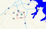
Airport Loop is the designation for the portions of state highways
that form a circumferential highway
around Baltimore/Washington International Thurgood Marshall Airport (BWI Airport) in Anne Arundel County
in the U.S. state
of Maryland
. The loop runs 8.44 miles (13.6 km) through the communities of Linthicum
, Ferndale
, and Hanover
. Airport Loop consists of a 3.47 miles (5.6 km) section of Maryland Route 170
(MD 170) along the western and northern sides of the loop; the entire 2.31 miles (3.7 km) length of MD 162
on the eastern side of the loop; and a 2.66 miles (4.3 km) segment of MD 176
on the southern side of the loop. Airport Loop intersects Interstate 195
, which provides freeway access to the airport terminal, and is connected to I-695
, I-97
, and MD 100
via connecting highways. The MD 170 and MD 162 sections of Airport Loop are part of the National Highway System
.
, which connect BWI Airport with Baltimore and Washington. Airport Loop passes under the BWI Trail and heads east as a four-lane divided highway. At the next intersection, the loop meets Elm Road, which heads south toward the airport terminal and hourly, daily, and express parking lots, and north toward Elkridge Landing Road, which passes through the BWI Hotel District and leads to off-site parking. Immediately east of the intersection, Airport Loop crosses at-grade the Baltimore Light Rail
. The loop passes to the south of the BWI Business District
station, whose kiss and ride and park and ride facilities can be accessed via Elkridge Landing Road at the next intersection. The air cargo facility is also accessed from that intersection. Airport Loop continues east, paralleling the light rail until the first route change occurs where MD 170 leaves the loop to the north as Camp Meade Road toward I-695
and the loop continues east as MD 162 (Aviation Boulevard).
Airport Loop passes the entrance to both long-term parking lots before intersecting Andover Road, which is unsigned MD 762 and connects with MD 170 in Linthicum. At this point, the loop turns south and is flanked by residential subdivisions to the east and the BWI Trail on the west. The next intersection features Ferndale Road heading east and the entrance to BWI Airport's general aviation facility. Airport Loop passes the offices of the Maryland Aviation Administration
before reaching Cromwell Drive, which serves an industrial park and leads to ramps to and from southbound I-97. Airport Loop continues south to an intersection with MD 176 (Dorsey Road) and Stewart Avenue. MD 176 east leads to an interchange with access to northbound I-97. Airport Loop turns west onto westbound MD 176.
Airport Loop heads west as a four-lane divided highway that reduces to a four-lane undivided highway with intermittent center turn lane as the highway passes the aircraft observation park, where the BWI Trail again parallels the loop. The loop passes the overflow parking facility on the north as it passes an industrial park on the south before reaching MD 652 (Old Telegraph Road). A long ramp for northbound MD 170, designated MD 170A, exits westbound MD 176 before MD 176 intersects MD 170, which heads south as Telegraph Road toward an interchange with MD 100 and north as Aviation Boulevard. Airport Loop turns north onto MD 170.
Airport Loop heads north as a four-lane undivided highway paralleled by the BWI Trail on the east and the Amtrak Northeast Corridor to the west through the trees. The loop intersects Stoney Run Road, which provides access to multiple rental car facilities and a business park. Stoney Run Road heads east then loops around to cross over Airport Loop; this is where the BWI Trail switches to the west side of the highway. At the intersection with Amtrak Way, which is unsigned MD 995 and leads to the BWI Rail Station
, the BWI Trail splits to the north to follow Amtrak Way as Airport Loop curves to the northeast. Airport Loop completes its circuit of BWI Airport at the interchange with I-195.
.
{| class=wikitable
!Location
!Mile
!Destinations
!Notes
|-
|rowspan=6|Linthicum
|0.00
| Washington
, Terminal
|I-195 Exit 1; partial cloverleaf interchange between MD 170 and I-195
|-
|0.41
|Elm Road south / To Elkridge Landing Road west
|Hotel District to west; Airport Hotel, Hourly, Daily, and Express Parking, TERMINAL to east
|-
|0.69
|Elkridge Landing Road west / Air Cargo Drive south
|North Cargo to south; Light Rail, Hotel District, Off-site Parking to north
|-
|1.16
|
|MD 170 leaves Airport Loop; northern terminus of MD 162
|-
|1.32
|Long Term Parking
|Long Term A to north; Long Term B to south
|-
|1.64
|
|MD 762 is unsigned
|-
|rowspan=3|Ferndale
|1.89
|Ferndale Road east / General Aviation
|General Aviation to the west
|-
|3.15
|Cromwell Park Drive east to
|Cromwell Park Drive is unsigned MD 162A
|-
|3.47
|
|Southern terminus of MD 162; MD 176 joins Airport Loop; ramp from MD 176 west to MD 170 north is unsigned MD 170A
|-
|rowspan=6|Hanover
|4.77
|Overflow Parking
|
|-
|5.49
|
|Old alignment of MD 170
|-
|6.13
|
|MD 176 leaves Airport Loop; MD 170 joins Airport Loop
|-
|7.41
|Stoney Run Road
|Car Rentals
|-
|8.00
|Amtrak Way – BWI Rail Station
|Unsigned MD 995
|-
|8.44
| Washington
, Terminal
|I-195 Exit 1; partial cloverleaf interchange between MD 170 and I-195
. The first 4.4 miles (7.1 km) section of the trail opened in July 1994 and was eventually completed in 1999. Described as a "linear park" circling BWI airport, the trail is believed to be the only one of its type in the entire United States.
State highway
State highway, state road or state route can refer to one of three related concepts, two of them related to a state or provincial government in a country that is divided into states or provinces :#A...
that form a circumferential highway
Circumferential Highway
Circumferential Highway may refer to one of the following beltways/orbital roads/ring roads:- Canada :* Nova Scotia Highway 111, known as the Dartmouth Circumferential Highway-Philippines:...
around Baltimore/Washington International Thurgood Marshall Airport (BWI Airport) in Anne Arundel County
Anne Arundel County, Maryland
Anne Arundel County is a county located in the U.S. state of Maryland. It is named for Anne Arundell , a member of the ancient family of Arundells in Cornwall, England and the wife of Cæcilius Calvert, 2nd Baron Baltimore. Its county seat is Annapolis, which is also the capital of the state...
in the U.S. state
U.S. state
A U.S. state is any one of the 50 federated states of the United States of America that share sovereignty with the federal government. Because of this shared sovereignty, an American is a citizen both of the federal entity and of his or her state of domicile. Four states use the official title of...
of Maryland
Maryland
Maryland is a U.S. state located in the Mid Atlantic region of the United States, bordering Virginia, West Virginia, and the District of Columbia to its south and west; Pennsylvania to its north; and Delaware to its east...
. The loop runs 8.44 miles (13.6 km) through the communities of Linthicum
Linthicum, Maryland
Linthicum is a census-designated place and an unincorporated community in Anne Arundel County, Maryland, United States. The population was 7,539 at the 2000 census. It is the approximate location of Baltimore-Washington International Thurgood Marshall Airport...
, Ferndale
Ferndale, Maryland
Ferndale is a census-designated place in Anne Arundel County, Maryland, in the United States. As of the 2000 census, the CDP population was 16,056.-Geography:Ferndale is located at ....
, and Hanover
Hanover, Maryland
Hanover, Maryland is a locality in unincorporated northwestern Anne Arundel County, Maryland in the United States, located south of Baltimore near the Howard County line....
. Airport Loop consists of a 3.47 miles (5.6 km) section of Maryland Route 170
Maryland Route 170
Maryland Route 170 is a roughly 13-mile-long road in Anne Arundel County.-Route description:MD 170 begins at the intersection of MD 175 Annapolis Road and Piney Orchard Parkway, in Odenton. It runs north towards Severn, interchanging with MD 32 northwest of the town...
(MD 170) along the western and northern sides of the loop; the entire 2.31 miles (3.7 km) length of MD 162
Maryland Route 162
Maryland Route 162 forms the eastern part of the Airport Loop around Baltimore-Washington International Thurgood Marshall Airport designated as Aviation Boulevard. It is long and Links Telegraph and Camp Meade Road with North Dorsey Road . Maryland Route 162 also provides access to Interstate 97...
on the eastern side of the loop; and a 2.66 miles (4.3 km) segment of MD 176
Maryland Route 176
Maryland Route 176 is an east–west route in Anne Arundel County.-Route description:MD 176 begins at a cul-de-sac near Wright Rd., a local neighborhood street, within sight of its old interchange with MD 295, now used by MD 100. Continuing east it intersects the northern end of MD 713 north of...
on the southern side of the loop. Airport Loop intersects Interstate 195
Interstate 195 (Maryland)
Interstate 195 is an Interstate highway in the U.S. state of Maryland. Known as Metropolitan Boulevard, the highway runs from Baltimore/Washington International Thurgood Marshall Airport in Linthicum north to I-95 in Arbutus, where Metropolitan Boulevard continues north as Maryland Route 166 ,...
, which provides freeway access to the airport terminal, and is connected to I-695
Interstate 695 (Maryland)
Interstate 695 is a -long full beltway Interstate Highway extending around Baltimore, Maryland, USA. I-695 is officially designated the McKeldin Beltway, but is colloquially referred to as either the Baltimore Beltway or 695...
, I-97
Interstate 97
Interstate 97 is an intrastate Interstate Highway located entirely within Anne Arundel County, Maryland, United States. It runs from Annapolis at the overlapped section of US 50, US 301, and the unsigned I-595 to Baltimore at the city's beltway...
, and MD 100
Maryland Route 100
Maryland Route 100 is a major east–west highway connecting U.S. Route 29 in Ellicott City and MD 177 in Pasadena. MD 100 also connects to Interstate 95 , US 1, the Baltimore-Washington Parkway , and I-97...
via connecting highways. The MD 170 and MD 162 sections of Airport Loop are part of the National Highway System
National Highway System (United States)
The National Highway System is a network of strategic highways within the United States, including the Interstate Highway System and other roads serving major airports, ports, rail or truck terminals, railway stations, pipeline terminals and other strategic transport facilities.Individual states...
.
Route description
Airport Loop begins at I-195 (Metropolitan Boulevard) signed as part of MD 170 (Aviation Boulevard). Airport Loop meets the Interstate highway at a partial cloverleaf interchange at the northwest corner of the loop. I-195 heads south to the airport terminal and north toward MD 295 (Baltimore–Washington Parkway) and I-95Interstate 95 in Maryland
Interstate 95 in Maryland is a major highway that runs diagonally from northeast to southwest, from Maryland's border with Delaware, to the Woodrow Wilson Bridge, briefly entering the District of Columbia before reaching Virginia...
, which connect BWI Airport with Baltimore and Washington. Airport Loop passes under the BWI Trail and heads east as a four-lane divided highway. At the next intersection, the loop meets Elm Road, which heads south toward the airport terminal and hourly, daily, and express parking lots, and north toward Elkridge Landing Road, which passes through the BWI Hotel District and leads to off-site parking. Immediately east of the intersection, Airport Loop crosses at-grade the Baltimore Light Rail
Baltimore Light Rail
The Maryland Transit Administration Light Rail is a light rail system serving Baltimore, Maryland, United States, and the surrounding suburbs.In downtown Baltimore it uses city streets...
. The loop passes to the south of the BWI Business District
BWI Business District (Baltimore Light Rail station)
BWI Business District is a stop on the Baltimore Light Rail system. There are currently 36 free public parking space and connections can be made to MTA Maryland's Route 17 and 99 buses, WMATA's B30 express bus, and Howard Transit's Silver Route from this station. Additionally, portions of the BWI...
station, whose kiss and ride and park and ride facilities can be accessed via Elkridge Landing Road at the next intersection. The air cargo facility is also accessed from that intersection. Airport Loop continues east, paralleling the light rail until the first route change occurs where MD 170 leaves the loop to the north as Camp Meade Road toward I-695
Interstate 695 (Maryland)
Interstate 695 is a -long full beltway Interstate Highway extending around Baltimore, Maryland, USA. I-695 is officially designated the McKeldin Beltway, but is colloquially referred to as either the Baltimore Beltway or 695...
and the loop continues east as MD 162 (Aviation Boulevard).
Airport Loop passes the entrance to both long-term parking lots before intersecting Andover Road, which is unsigned MD 762 and connects with MD 170 in Linthicum. At this point, the loop turns south and is flanked by residential subdivisions to the east and the BWI Trail on the west. The next intersection features Ferndale Road heading east and the entrance to BWI Airport's general aviation facility. Airport Loop passes the offices of the Maryland Aviation Administration
Maryland Aviation Administration
The Maryland Aviation Administration is a state agency of Maryland and an airport authority under the jurisdiction of the Maryland Department of Transportation. The agency controls Baltimore/Washington International Thurgood Marshall Airport and Martin State Airport...
before reaching Cromwell Drive, which serves an industrial park and leads to ramps to and from southbound I-97. Airport Loop continues south to an intersection with MD 176 (Dorsey Road) and Stewart Avenue. MD 176 east leads to an interchange with access to northbound I-97. Airport Loop turns west onto westbound MD 176.
Airport Loop heads west as a four-lane divided highway that reduces to a four-lane undivided highway with intermittent center turn lane as the highway passes the aircraft observation park, where the BWI Trail again parallels the loop. The loop passes the overflow parking facility on the north as it passes an industrial park on the south before reaching MD 652 (Old Telegraph Road). A long ramp for northbound MD 170, designated MD 170A, exits westbound MD 176 before MD 176 intersects MD 170, which heads south as Telegraph Road toward an interchange with MD 100 and north as Aviation Boulevard. Airport Loop turns north onto MD 170.
Airport Loop heads north as a four-lane undivided highway paralleled by the BWI Trail on the east and the Amtrak Northeast Corridor to the west through the trees. The loop intersects Stoney Run Road, which provides access to multiple rental car facilities and a business park. Stoney Run Road heads east then loops around to cross over Airport Loop; this is where the BWI Trail switches to the west side of the highway. At the intersection with Amtrak Way, which is unsigned MD 995 and leads to the BWI Rail Station
BWI Rail Station
The Baltimore/Washington International Thurgood Marshall Airport Rail Station is an Amtrak and MARC commuter rail train station in Linthicum, an unincorporated area in Anne Arundel County, Maryland, United States....
, the BWI Trail splits to the north to follow Amtrak Way as Airport Loop curves to the northeast. Airport Loop completes its circuit of BWI Airport at the interchange with I-195.
Junction list
Airport Loop runs clockwise around BWI Airport. For purposes of this list, mile 0 is located at the I-195 interchange. The entire route is in Anne Arundel CountyAnne Arundel County, Maryland
Anne Arundel County is a county located in the U.S. state of Maryland. It is named for Anne Arundell , a member of the ancient family of Arundells in Cornwall, England and the wife of Cæcilius Calvert, 2nd Baron Baltimore. Its county seat is Annapolis, which is also the capital of the state...
.
{| class=wikitable
!Location
!Mile
!Destinations
!Notes
|-
|rowspan=6|Linthicum
Linthicum, Maryland
Linthicum is a census-designated place and an unincorporated community in Anne Arundel County, Maryland, United States. The population was 7,539 at the 2000 census. It is the approximate location of Baltimore-Washington International Thurgood Marshall Airport...
|0.00
| Washington
Washington, D.C.
Washington, D.C., formally the District of Columbia and commonly referred to as Washington, "the District", or simply D.C., is the capital of the United States. On July 16, 1790, the United States Congress approved the creation of a permanent national capital as permitted by the U.S. Constitution....
, Terminal
|I-195 Exit 1; partial cloverleaf interchange between MD 170 and I-195
|-
|0.41
|Elm Road south / To Elkridge Landing Road west
|Hotel District to west; Airport Hotel, Hourly, Daily, and Express Parking, TERMINAL to east
|-
|0.69
|Elkridge Landing Road west / Air Cargo Drive south
|North Cargo to south; Light Rail, Hotel District, Off-site Parking to north
|-
|1.16
|
|MD 170 leaves Airport Loop; northern terminus of MD 162
|-
|1.32
|Long Term Parking
|Long Term A to north; Long Term B to south
|-
|1.64
|
|MD 762 is unsigned
|-
|rowspan=3|Ferndale
Ferndale, Maryland
Ferndale is a census-designated place in Anne Arundel County, Maryland, in the United States. As of the 2000 census, the CDP population was 16,056.-Geography:Ferndale is located at ....
|1.89
|Ferndale Road east / General Aviation
|General Aviation to the west
|-
|3.15
|Cromwell Park Drive east to
|Cromwell Park Drive is unsigned MD 162A
|-
|3.47
|
|Southern terminus of MD 162; MD 176 joins Airport Loop; ramp from MD 176 west to MD 170 north is unsigned MD 170A
|-
|rowspan=6|Hanover
Hanover, Maryland
Hanover, Maryland is a locality in unincorporated northwestern Anne Arundel County, Maryland in the United States, located south of Baltimore near the Howard County line....
|4.77
|Overflow Parking
|
|-
|5.49
|
|Old alignment of MD 170
|-
|6.13
|
|MD 176 leaves Airport Loop; MD 170 joins Airport Loop
|-
|7.41
|Stoney Run Road
|Car Rentals
|-
|8.00
|Amtrak Way – BWI Rail Station
BWI Rail Station
The Baltimore/Washington International Thurgood Marshall Airport Rail Station is an Amtrak and MARC commuter rail train station in Linthicum, an unincorporated area in Anne Arundel County, Maryland, United States....
|Unsigned MD 995
|-
|8.44
| Washington
Washington, D.C.
Washington, D.C., formally the District of Columbia and commonly referred to as Washington, "the District", or simply D.C., is the capital of the United States. On July 16, 1790, the United States Congress approved the creation of a permanent national capital as permitted by the U.S. Constitution....
, Terminal
|I-195 Exit 1; partial cloverleaf interchange between MD 170 and I-195
BWI Trail
The pedestrian companion to the Airport Loop is the BWI Trail, a 13.3 miles (21.4 km) biking/hiking trail that completely encircles BWI Airport and is reachable from the Baltimore & Annapolis TrailBaltimore & Annapolis Trail
The Baltimore & Annapolis Trail is a rail trail in Anne Arundel County, Maryland. The trail starts at Boulter's Way in Arnold and ends near Baltimore Light Rail's Cromwell Station in Glen Burnie. Starting near Annapolis at Jonas Green State Park, the trail passes through Arnold, Severna Park,...
. The first 4.4 miles (7.1 km) section of the trail opened in July 1994 and was eventually completed in 1999. Described as a "linear park" circling BWI airport, the trail is believed to be the only one of its type in the entire United States.
External links
- Maryland 170
- BWI Airport: The BWI Trail
- Good map of the BWI Trail
- "The BWI Trail" Maryland Department of Natural Resources