
Meiktila
Encyclopedia
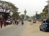
Meiktila is a city in central Myanmar
, located on the banks of Lake Meiktila
in Mandalay Division
, at the junctions of the Bagan
-Taunggyi
, Yangon
-Mandalay
and Meiktila-Myingyan
highways. Because of its strategic position, Meiktila is home to Myanmar Air Force's central command and Meiktila Air Force Base. The country's main aerospace engineering university, Myanmar Aerospace Engineering University
is also located in Meiktila.
(Burmans). The region had been part of various Burman kingdoms at least from 11th century CE to 19th century CE before the British
took over all of Upper Myanmar in 1885.
Meiktila was the site of the 1945 battle of Meiktila, in which the Allies
forces under William Slim defeated the Japanese
forces. Soon after Myanmar's independence from Britain in 1948, Meiktila briefly fell under the insurgent Karen forces.
, Myingyan, Yamethin
, and touches Shan State
on the east. The chief feature of the region Lake Meiktila, an artificial irrigation
and water reservoir
, 7 miles (11.3 km) long, 0.5 mile (0.80467 km) wide. Mondai dam supplies water to the lake.
, and regional universities and colleges such as Meiktila University, Meiktila Institute of Economics
, Computer University, Meiktila
, Technological University, Meiktila and Meiktila Education College.
Of the city's six public Basic Education High Schools
, BEHS 1 Meiktila or Royal High School is considered the most selective.
Myanmar
Burma , officially the Republic of the Union of Myanmar , is a country in Southeast Asia. Burma is bordered by China on the northeast, Laos on the east, Thailand on the southeast, Bangladesh on the west, India on the northwest, the Bay of Bengal to the southwest, and the Andaman Sea on the south....
, located on the banks of Lake Meiktila
Lake Meiktila
Lake Meiktila is a lake located near Meiktila, Myanmar . It is 7 miles long, averages half a mile across, and covers an area of 3.5 sq. mile. Mone-Dai dam supplies water to the lake. It is divided into two parts, north lake and south lake. It is divided by a bridge across the lake.The lake is an...
in Mandalay Division
Mandalay Division
Mandalay Region is an administrative division of Myanmar. It is located in the center of the country, bordering Sagaing Region and Magway Region to the west, Shan State to the east, and Bago Region and Kayin State to the south. The regional capital is Mandalay. In the south of the division lies...
, at the junctions of the Bagan
Bagan
Bagan , formerly Pagan, is an ancient city in the Mandalay Region of Burma. Formally titled Arimaddanapura or Arimaddana and also known as Tambadipa or Tassadessa , it was the capital of several ancient kingdoms in Burma...
-Taunggyi
Taunggyi
-Transportation:The main access to Taunggyi is by road. A railway line that passes through Taunggyi was recently built in 1995, but at the moment it offers no passenger service. Regular railway passenger service to the rest of the country is through the town of Shwenyaung, twelve miles to the...
, Yangon
Yangon
Yangon is a former capital of Burma and the capital of Yangon Region . Although the military government has officially relocated the capital to Naypyidaw since March 2006, Yangon, with a population of over four million, continues to be the country's largest city and the most important commercial...
-Mandalay
Mandalay
Mandalay is the second-largest city and the last royal capital of Burma. Located north of Yangon on the east bank of the Irrawaddy River, the city has a population of one million, and is the capital of Mandalay Region ....
and Meiktila-Myingyan
Myingyan
Myingyan is a city and district in the Mandalay Division of central Myanmar, previously, it was a district in the Meiktila Division of Upper Burma. It is currently the capital of Myingyan Township and lies along the National Highway 2. , the city had a population of 123,700 and the district had...
highways. Because of its strategic position, Meiktila is home to Myanmar Air Force's central command and Meiktila Air Force Base. The country's main aerospace engineering university, Myanmar Aerospace Engineering University
Myanmar Aerospace Engineering University
Myanmar Aerospace Engineering University is a specialized public university of aerospace engineering, located in Meiktila, Myanmar. The university offers undergraduate diploma, bachelor's degree and post-graduate diploma programs in several aerospace engineering specializations and...
is also located in Meiktila.
History
The history of Meiktila is closely tied to that of central Myanmar's dry zone, home of the BamarBamar
The Bamar are the dominant ethnic group of Burma , constituting approximately two-thirds of the population. The Bamar live primarily in the Irrawaddy basin, and speak the Burmese language, which is also the official language of Burma. Bamar customs and identity are closely intertwined with general...
(Burmans). The region had been part of various Burman kingdoms at least from 11th century CE to 19th century CE before the British
British Empire
The British Empire comprised the dominions, colonies, protectorates, mandates and other territories ruled or administered by the United Kingdom. It originated with the overseas colonies and trading posts established by England in the late 16th and early 17th centuries. At its height, it was the...
took over all of Upper Myanmar in 1885.
Meiktila was the site of the 1945 battle of Meiktila, in which the Allies
Allies
In everyday English usage, allies are people, groups, or nations that have joined together in an association for mutual benefit or to achieve some common purpose, whether or not explicit agreement has been worked out between them...
forces under William Slim defeated the Japanese
Empire of Japan
The Empire of Japan is the name of the state of Japan that existed from the Meiji Restoration on 3 January 1868 to the enactment of the post-World War II Constitution of...
forces. Soon after Myanmar's independence from Britain in 1948, Meiktila briefly fell under the insurgent Karen forces.
Geography
Meiktila district is the most easterly of the districts in Myanmar's central dry zone. It lies between WundwinWundwin
-External links:*...
, Myingyan, Yamethin
Yamethin
Yamethin is a town in central Burma in Yamethin District, Mandalay Region. Yamethin provides a market and processing for local agriculture production of rice and beans, as well having a small textile industry, and serving as a railroad shipping point on the Rangoon – Mandalay...
, and touches Shan State
Shan State
Shan State is a state of Burma . Shan State borders China to the north, Laos to the east, and Thailand to the south, and five administrative divisions of Burma in the west. Largest of the 14 administrative divisions by land area, Shan State covers 155,800 km², almost a quarter of the total...
on the east. The chief feature of the region Lake Meiktila, an artificial irrigation
Irrigation
Irrigation may be defined as the science of artificial application of water to the land or soil. It is used to assist in the growing of agricultural crops, maintenance of landscapes, and revegetation of disturbed soils in dry areas and during periods of inadequate rainfall...
and water reservoir
Water reservoir
A reservoir , artificial lake or dam is used to store water.Reservoirs may be created in river valleys by the construction of a dam or may be built by excavation in the ground or by conventional construction techniques such as brickwork or cast concrete.The term reservoir may also be used to...
, 7 miles (11.3 km) long, 0.5 mile (0.80467 km) wide. Mondai dam supplies water to the lake.
Education
Meiktila is home to a national university in Myanmar Aerospace Engineering UniversityMyanmar Aerospace Engineering University
Myanmar Aerospace Engineering University is a specialized public university of aerospace engineering, located in Meiktila, Myanmar. The university offers undergraduate diploma, bachelor's degree and post-graduate diploma programs in several aerospace engineering specializations and...
, and regional universities and colleges such as Meiktila University, Meiktila Institute of Economics
Meiktila Institute of Economics
The Meiktila Institute of Economics , located in Meiktila, Mandalay Region, is one of three universities of economics and business in Myanmar. The institute offers undergraduate and graduate degrees and diplomas, mostly in commerce, statistics and economics. It also has a small number of graduate...
, Computer University, Meiktila
Computer University, Meiktila
Computer University, Meiktila is a university located in Meiktila , Mandalay Division, Myanmar....
, Technological University, Meiktila and Meiktila Education College.
Of the city's six public Basic Education High Schools
High schools in Burma
High schools in Myanmar are operated by the Department of Basic Education under the Ministry of Education in Myanmar. The present education system has not changed since the re-opening of the schools in 1989, under the SLORC...
, BEHS 1 Meiktila or Royal High School is considered the most selective.