Adelaide Island
Encyclopedia
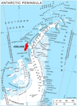
Adelaide Island or Isla Adelaida or Isla Belgrano is a large, mainly ice-covered island
, 75 miles (120.7 km) long and 20 miles (32.2 km) wide, lying at the north side of Marguerite Bay
off the west coast of the Antarctic Peninsula
. The island lies within the Argentine
, British
and Chilean Antarctic claims, at 67.25°S 68.5°W.
Adelaide Island was discovered in 1832 by a British
expedition under John Biscoe
. The island was first surveyed by the French Antarctic Expedition
(1908–1910) under Jean-Baptiste Charcot.
The source of the island's name is unknown. British Antarctic Survey
records state that Charcot named the island "Adelie Land" after the huge number of Adelie Penguin
s that lived on its coast (the penguins being named after the wife of Dumont d'Urville). This in turn was turned into Adelaide Island by the British Graham Land Expedition
(1934–37). It has also been supposed that the island was in fact named by Biscoe himself for Queen Adelaide of the United Kingdom
.
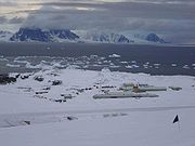
 The Island has 2 bases on it. The old Adelaide Island base (also known as Base T) was set up by the Falkland Islands Dependent Survey (FIDS), which became the British Antarctic Survey. The Base was closed due to an unstable skiway and operations were moved to the new Rothera Station during 1976 / 1977, this base remains open to this day. The old BAS base was transferred to the Chile
an authorities in 1984, when it was renamed Teniente Luis Carvajal Villaroel Antarctic Base
. The station was then used as a summer only station by the Chileans. However the skiway, and 'ramp' to the station from the plateau have all become so unstable, that the Chilean Air Force
(FACh) have stopped all their activities there. The Chilean Navy
have visited the station almost every summer to ensure it is in good keeping. BAS employees also visit the station during the winter when access from the plateau is easier.
Due to the length of time that it has been inhabited the island is well mapped by Antarctic standards.
Island
An island or isle is any piece of sub-continental land that is surrounded by water. Very small islands such as emergent land features on atolls can be called islets, cays or keys. An island in a river or lake may be called an eyot , or holm...
, 75 miles (120.7 km) long and 20 miles (32.2 km) wide, lying at the north side of Marguerite Bay
Marguerite Bay
Marguerite Bay or Margaret Bay is an extensive bay on the west side of the Antarctic Peninsula, which is bounded on the north by Adelaide Island and on the south by Wordie Ice Shelf, George VI Sound and Alexander Island. The mainland coast on the Antarctic Peninsula is Fallières Coast. Islands...
off the west coast of the Antarctic Peninsula
Antarctic Peninsula
The Antarctic Peninsula is the northernmost part of the mainland of Antarctica. It extends from a line between Cape Adams and a point on the mainland south of Eklund Islands....
. The island lies within the Argentine
Argentine Antarctica
Argentine Antarctica is a sector of Antarctica claimed by Argentina as part of its national territory. The Argentine Antarctic region, consisting of the Antarctic Peninsula and a triangular section extending to the South Pole, is delimited by the 25° West and 74° West meridians and the 60° South...
, British
British Antarctic Territory
The British Antarctic Territory is a sector of Antarctica claimed by the United Kingdom as one of its 14 British Overseas Territories. It comprises the region south of 60°S latitude and between longitudes and , forming a wedge shape that extends to the South Pole...
and Chilean Antarctic claims, at 67.25°S 68.5°W.
Adelaide Island was discovered in 1832 by a British
United Kingdom of Great Britain and Ireland
The United Kingdom of Great Britain and Ireland was the formal name of the United Kingdom during the period when what is now the Republic of Ireland formed a part of it....
expedition under John Biscoe
John Biscoe
John Biscoe was an English mariner and explorer who commanded the first expedition known to have sighted the areas named Enderby Land and Graham Land along the coast of Antarctica...
. The island was first surveyed by the French Antarctic Expedition
French Antarctic Expedition
French Antarctic Expedition refers to several French expeditions in Antarctica.-First expedition:Yves-Joseph de Kerguelen-Trémarec was a French explorer....
(1908–1910) under Jean-Baptiste Charcot.
The source of the island's name is unknown. British Antarctic Survey
British Antarctic Survey
The British Antarctic Survey is the United Kingdom's national Antarctic operation and has an active role in Antarctic affairs. BAS is part of the Natural Environment Research Council and has over 400 staff. It operates five research stations, two ships and five aircraft in and around Antarctica....
records state that Charcot named the island "Adelie Land" after the huge number of Adelie Penguin
Adelie Penguin
The Adélie Penguin, Pygoscelis adeliae, is a species of penguin common along the entire Antarctic coast. They are among the most southerly distributed of all seabirds, as are the Emperor Penguin, the South Polar Skua, the Wilson's Storm Petrel, the Snow Petrel, and the Antarctic Petrel...
s that lived on its coast (the penguins being named after the wife of Dumont d'Urville). This in turn was turned into Adelaide Island by the British Graham Land Expedition
British Graham Land Expedition
A British expedition to Graham Land led by John Lachlan Cope took place between 1920 and 1922. The British Graham Land Expedition was a geophysical and exploration expedition to Graham Land in Antarctica between 1934 to 1937. Under the leadership of John Riddoch Rymill, the expedition spent two...
(1934–37). It has also been supposed that the island was in fact named by Biscoe himself for Queen Adelaide of the United Kingdom
Adelaide of Saxe-Meiningen
Princess Adelaide of Saxe-Meiningen was the queen consort of the United Kingdom and of Hanover as spouse of William IV of the United Kingdom. Adelaide, the capital city of South Australia, is named after her.-Early life:Adelaide was born on 13 August 1792 at Meiningen, Thuringia, Germany...
.

Chile
Chile ,officially the Republic of Chile , is a country in South America occupying a long, narrow coastal strip between the Andes mountains to the east and the Pacific Ocean to the west. It borders Peru to the north, Bolivia to the northeast, Argentina to the east, and the Drake Passage in the far...
an authorities in 1984, when it was renamed Teniente Luis Carvajal Villaroel Antarctic Base
Teniente Luis Carvajal Villaroel Antarctic Base
Previously the British Antarctic Survey Station T - Adelaide Base . The base was established by Falkland Islands Dependencies Survey in 1961....
. The station was then used as a summer only station by the Chileans. However the skiway, and 'ramp' to the station from the plateau have all become so unstable, that the Chilean Air Force
Chilean Air Force
The Chilean Air Force is the air force of Chile, a branch of the Chilean military.-History:The first step towards the current FACh was taken by Teniente Coronel Pedro Pablo Dartnell, when he founded the Servicio de Aviación Militar de Chile on December 20, 1910, being trained as a pilot in France...
(FACh) have stopped all their activities there. The Chilean Navy
Chilean Navy
-Independence Wars of Chile and Peru :The Chilean Navy dates back to 1817. A year before, following the Battle of Chacabuco, General Bernardo O'Higgins prophetically declared "this victory and another hundred shall be of no significance if we do not gain control of the sea".This led to the...
have visited the station almost every summer to ensure it is in good keeping. BAS employees also visit the station during the winter when access from the plateau is easier.
Due to the length of time that it has been inhabited the island is well mapped by Antarctic standards.
See also
- BASBritish Antarctic SurveyThe British Antarctic Survey is the United Kingdom's national Antarctic operation and has an active role in Antarctic affairs. BAS is part of the Natural Environment Research Council and has over 400 staff. It operates five research stations, two ships and five aircraft in and around Antarctica....
- Composite Antarctic Gazetteer
- List of Antarctic islands south of 60° S
- SCARScarScars are areas of fibrous tissue that replace normal skin after injury. A scar results from the biological process of wound repair in the skin and other tissues of the body. Thus, scarring is a natural part of the healing process. With the exception of very minor lesions, every wound results in...
- Territorial claims in Antarctica

