
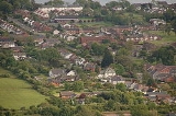
Greenisland
Encyclopedia
Greenisland is a village in County Antrim
, Northern Ireland
. It lies 7 miles north-east of Belfast and 3 miles south-west of Carrickfergus
. The village is on the coast of Belfast Lough
and is named after a tiny islet
to the west, the Green Island.
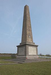
It is a semi-rural community located at the foot of Carn Hill, known locally as Knockagh Hill, upon which stands the Knockagh Monument
, a war memorial for those from County Antrim
who died in the first
and second
world wars.
The village has two distinct areas, known locally as Upper Greenisland and Lower Greenisland after the Upper Station Road and Lower Station Road around which two parts are respectively located. Upper Greenisland stretches from Upper Road (B90) to the railway station
at the bottom of Upper Station Road, includes Greenisland Primary School and features predominantly middle-class demographics and housing. Lower Greenisland runs from the railway station
, down the Lower Station Road and ends at Shore Road (part of the A2 road
). It features a large, predominantly working-class housing estate built during the 1950s and 1960s and includes Greenisland Library and a small shopping parade at Glassillan Court. The village in its entirety stretches from the foot of the hill to the shore of Belfast Lough
.
with the Silverstream river, now the western boundary of Greenisland, marking the westernmost boundary of the large town. Today, roadsigns indicate that the river, which now flows through the grounds of Belfast High School
, is the exact boundary between the Carrickfergus Borough Council
and Newtownabbey Borough Council
areas. From 1602 to 1606 the "freemen", leading citizens of Carrickfergus, obtained the right to redistribute this area of land from The Crown
, renaming the area the West Division - a name which remains legal today.
Farmland was distributed in strips from Carn Hill, known locally as Knockagh Hill, to the shore of Belfast Lough
and lanes were constructed to provide access to the farms and their houses, including important residences such as Castle Lugg. The most notable of these was Longfield Lane, which was eventually widened and surfaced to provide access to the railway station, becoming the Station Road. Many of the lanes also remain in their original narrow state, such as Neill's Lane and Windfield Lane both of which run north from the Shore Road on either side of Greenisland.
In the 1800s, following the growth of Belfast
towards the end of the 18th century, several bathing lodges used for summer recreation were established in the area. One such lodge is still standing today and has been transformed into "Ravenhill Nursing Home" by the Northern Health and Social Care Trust. During this period, Bassett’s directory of 1888 notes that the area was "devoted entirely to handsome residences occupied for the greater part by gentlemen engaged in commercial and professional pursuits in Belfast".
The Belfast to Ballymena
railway line was opened in 1845, which travelled through the area, providing one of the first transport links to the village from both Belfast and Carrickfergus. The village was finally given the official name of Greenisland in 1893 when the Greenisland railway station was constructed in its present site. Improvements in transport and a growth in prosperity led to more semi-detached and terraced houses in the area immediately surrounding the railway station.
In 1859 the Christian Revival that swept Ulster arrived in Greenisland and an open air service was held in the field below Longfield Farm (now known locally as Johnstone Farm) which is still standing on the Station Road. By 1860 the interdenominational Ebenezer Hall was built for worshippers on the Shore Road. This was then followed in 1912 when the Presbyterian Knockagh Hall was built on the Upper Road. Neither of these buildings survive, however the congregations of these two churches remain. With Greenisland Ebenezer Church of the Nazarene now in Longfield Gardens and Greenisland Presbyterian Church on the Upper Road. Over the years they have been joined by several other churches as Greenisland has grown.
Greenisland Primary School replaced a school in Trooperslane in 1938, when it was realised that children were being forced to walk two miles to Trooperslane and back every day. On the opening day, pupils arrived at the Trooperslane school and then walked to the new school carrying armfuls of books, jars of ink and other learning materials.
During World War II
, the new school's headmaster, as an army reserve, was called into action. Soon after, an air raid shelter was built in the playground and gas masks were placed under desks, where the pupils would store their bags. Village residents formed a Home Guard and Civil Defence Post and air raid drills became regular free 'entertainment' in the evenings. Stirrup pumps were issued to put out fires and proved very useful for watering gardens during the summer. The name on the outside of the school was covered during the war so that any German parachutists landing in Greenisland would be disorientated, not knowing where they were.
In Easter 1941
, when a German
plane was reported to have flown up the Lough
towards Belfast, the anti-aircraft battery on Neill's Lane opened fire. It was the only occasion during the war that necessitated the air-raid shelters in Greenisland. The guns did not bring down any aircraft and only managed to crack some windows in the village. However, it was soon realised that a full-scale attack had been waged on the city of Belfast (today known as the Belfast Blitz
, the greatest loss of life outside London
during the blitz
) and the village's Air Raid Precautions
volunteers disappeared into Belfast for several days to help with the recovery.
A snapshot of life in Greenisland in 1986 can be found by visiting BBC Domesday Reloaded website here.
The area is also served by the local NEELB
Library, and has a community centre, youth centre and Scout hall.
, opened on 11 April 1848, provides direct rail links in both the Belfast
and Larne
directions, from around 5am until 11pm. The vast majority of train services from the Belfast and Larne directions stop at Greenisland, with the exception of occasional express Belfast to Carrickfergus services.
The vast majority of Ulsterbus
Belfast and Carrickfergus
/Whitehead
bus services take a ten minute detour into the Greenisland estate before continuing to their destination, providing the village with frequent transport links in each direction.
and forms part of the Knockagh district electoral area.
Local Councillors are:
Local MLAs for the area include:
Local MP is:
The MEP's for the area are:
Shore Road. Conor Murphy (then, Regional Development Minister) stated in June 2010 that subject to "finances being available, delivery is expected to start in 2011-12, and the project should be completed in 2013". This has now been delayed until finances can be found within the next budget. No new dates have been given.
County Antrim
County Antrim is one of six counties that form Northern Ireland, situated in the north-east of the island of Ireland. Adjoined to the north-east shore of Lough Neagh, the county covers an area of 2,844 km², with a population of approximately 616,000...
, Northern Ireland
Northern Ireland
Northern Ireland is one of the four countries of the United Kingdom. Situated in the north-east of the island of Ireland, it shares a border with the Republic of Ireland to the south and west...
. It lies 7 miles north-east of Belfast and 3 miles south-west of Carrickfergus
Carrickfergus
Carrickfergus , known locally and colloquially as "Carrick", is a large town in County Antrim, Northern Ireland. It is located on the north shore of Belfast Lough, from Belfast. The town had a population of 27,201 at the 2001 Census and takes its name from Fergus Mór mac Eirc, the 6th century king...
. The village is on the coast of Belfast Lough
Belfast Lough
Belfast Lough is a large, natural intertidal sea lough at the mouth of the River Lagan on the east coast of Northern Ireland. The inner part of the lough comprises a series of mudflats and lagoons. The outer lough is restricted to mainly rocky shores with some small sandy bays...
and is named after a tiny islet
Islet
An islet is a very small island.- Types :As suggested by its origin as islette, an Old French diminutive of "isle", use of the term implies small size, but little attention is given to drawing an upper limit on its applicability....
to the west, the Green Island.
It is a semi-rural community located at the foot of Carn Hill, known locally as Knockagh Hill, upon which stands the Knockagh Monument
Knockagh Monument
The Knockagh Monument is a war memorial in County Antrim, Northern Ireland. It is located on top of Knockagh Hill, above the village of Greenisland with a panoramic view of the city of Belfast.-Features:...
, a war memorial for those from County Antrim
County Antrim
County Antrim is one of six counties that form Northern Ireland, situated in the north-east of the island of Ireland. Adjoined to the north-east shore of Lough Neagh, the county covers an area of 2,844 km², with a population of approximately 616,000...
who died in the first
World War I
World War I , which was predominantly called the World War or the Great War from its occurrence until 1939, and the First World War or World War I thereafter, was a major war centred in Europe that began on 28 July 1914 and lasted until 11 November 1918...
and second
World War II
World War II, or the Second World War , was a global conflict lasting from 1939 to 1945, involving most of the world's nations—including all of the great powers—eventually forming two opposing military alliances: the Allies and the Axis...
world wars.
The village has two distinct areas, known locally as Upper Greenisland and Lower Greenisland after the Upper Station Road and Lower Station Road around which two parts are respectively located. Upper Greenisland stretches from Upper Road (B90) to the railway station
Greenisland railway station
Greenisland railway station serves Greenisland in County Antrim, Northern Ireland. The station opened on 11 April 1848 as Carrickfergus Junction. It was renamed on 10 January 1893...
at the bottom of Upper Station Road, includes Greenisland Primary School and features predominantly middle-class demographics and housing. Lower Greenisland runs from the railway station
Greenisland railway station
Greenisland railway station serves Greenisland in County Antrim, Northern Ireland. The station opened on 11 April 1848 as Carrickfergus Junction. It was renamed on 10 January 1893...
, down the Lower Station Road and ends at Shore Road (part of the A2 road
A2 road (Northern Ireland)
The A2 is a major road in Northern Ireland, a large section of which is often called the Antrim Coast Road because it follows the scenic coastline of County Antrim....
). It features a large, predominantly working-class housing estate built during the 1950s and 1960s and includes Greenisland Library and a small shopping parade at Glassillan Court. The village in its entirety stretches from the foot of the hill to the shore of Belfast Lough
Belfast Lough
Belfast Lough is a large, natural intertidal sea lough at the mouth of the River Lagan on the east coast of Northern Ireland. The inner part of the lough comprises a series of mudflats and lagoons. The outer lough is restricted to mainly rocky shores with some small sandy bays...
.
History
Originally, the area now known as Greenisland was merely an unnamed area of the town of CarrickfergusCarrickfergus
Carrickfergus , known locally and colloquially as "Carrick", is a large town in County Antrim, Northern Ireland. It is located on the north shore of Belfast Lough, from Belfast. The town had a population of 27,201 at the 2001 Census and takes its name from Fergus Mór mac Eirc, the 6th century king...
with the Silverstream river, now the western boundary of Greenisland, marking the westernmost boundary of the large town. Today, roadsigns indicate that the river, which now flows through the grounds of Belfast High School
Belfast High School
Belfast High School is a Voluntary Grammar School located at Jordanstown in Newtownabbey, County Antrim, Northern Ireland. It lies within the North Eastern Education and Library Board area....
, is the exact boundary between the Carrickfergus Borough Council
Carrickfergus Borough Council
Carrickfergus Borough Council is a district council in County Antrim in Northern Ireland. The council headquarters are in Carrickfergus and the council administers the town, on the north shore of Belfast Lough, and surrounding area, which extends from Greenisland in the south-west to Whitehead in...
and Newtownabbey Borough Council
Newtownabbey Borough Council
Newtownabbey Borough Council is a Local Council in County Antrim in Northern Ireland. Newtownabbey has a population of over 80,000 and is on the north shore of Belfast Lough just immediately north of Belfast. The Borough was founded in 1958 as a result of an Act of Parliament passed in 1957 and...
areas. From 1602 to 1606 the "freemen", leading citizens of Carrickfergus, obtained the right to redistribute this area of land from The Crown
The Crown
The Crown is a corporation sole that in the Commonwealth realms and any provincial or state sub-divisions thereof represents the legal embodiment of governance, whether executive, legislative, or judicial...
, renaming the area the West Division - a name which remains legal today.
Farmland was distributed in strips from Carn Hill, known locally as Knockagh Hill, to the shore of Belfast Lough
Belfast Lough
Belfast Lough is a large, natural intertidal sea lough at the mouth of the River Lagan on the east coast of Northern Ireland. The inner part of the lough comprises a series of mudflats and lagoons. The outer lough is restricted to mainly rocky shores with some small sandy bays...
and lanes were constructed to provide access to the farms and their houses, including important residences such as Castle Lugg. The most notable of these was Longfield Lane, which was eventually widened and surfaced to provide access to the railway station, becoming the Station Road. Many of the lanes also remain in their original narrow state, such as Neill's Lane and Windfield Lane both of which run north from the Shore Road on either side of Greenisland.
In the 1800s, following the growth of Belfast
Belfast
Belfast is the capital of and largest city in Northern Ireland. By population, it is the 14th biggest city in the United Kingdom and second biggest on the island of Ireland . It is the seat of the devolved government and legislative Northern Ireland Assembly...
towards the end of the 18th century, several bathing lodges used for summer recreation were established in the area. One such lodge is still standing today and has been transformed into "Ravenhill Nursing Home" by the Northern Health and Social Care Trust. During this period, Bassett’s directory of 1888 notes that the area was "devoted entirely to handsome residences occupied for the greater part by gentlemen engaged in commercial and professional pursuits in Belfast".
The Belfast to Ballymena
Ballymena
Ballymena is a large town in County Antrim, Northern Ireland and the seat of Ballymena Borough Council. Ballymena had a population of 28,717 people in the 2001 Census....
railway line was opened in 1845, which travelled through the area, providing one of the first transport links to the village from both Belfast and Carrickfergus. The village was finally given the official name of Greenisland in 1893 when the Greenisland railway station was constructed in its present site. Improvements in transport and a growth in prosperity led to more semi-detached and terraced houses in the area immediately surrounding the railway station.
In 1859 the Christian Revival that swept Ulster arrived in Greenisland and an open air service was held in the field below Longfield Farm (now known locally as Johnstone Farm) which is still standing on the Station Road. By 1860 the interdenominational Ebenezer Hall was built for worshippers on the Shore Road. This was then followed in 1912 when the Presbyterian Knockagh Hall was built on the Upper Road. Neither of these buildings survive, however the congregations of these two churches remain. With Greenisland Ebenezer Church of the Nazarene now in Longfield Gardens and Greenisland Presbyterian Church on the Upper Road. Over the years they have been joined by several other churches as Greenisland has grown.
Greenisland Primary School replaced a school in Trooperslane in 1938, when it was realised that children were being forced to walk two miles to Trooperslane and back every day. On the opening day, pupils arrived at the Trooperslane school and then walked to the new school carrying armfuls of books, jars of ink and other learning materials.
During World War II
World War II
World War II, or the Second World War , was a global conflict lasting from 1939 to 1945, involving most of the world's nations—including all of the great powers—eventually forming two opposing military alliances: the Allies and the Axis...
, the new school's headmaster, as an army reserve, was called into action. Soon after, an air raid shelter was built in the playground and gas masks were placed under desks, where the pupils would store their bags. Village residents formed a Home Guard and Civil Defence Post and air raid drills became regular free 'entertainment' in the evenings. Stirrup pumps were issued to put out fires and proved very useful for watering gardens during the summer. The name on the outside of the school was covered during the war so that any German parachutists landing in Greenisland would be disorientated, not knowing where they were.
In Easter 1941
Belfast Blitz
The Belfast Blitz was an event that occurred on the night of Easter Tuesday, 15 April 1941 during World War II. Two hundred bombers of the German Air Force attacked the city of Belfast in Northern Ireland. Nearly one thousand people died as a result of the bombing and 1,500 were injured. In terms...
, when a German
Nazi Germany
Nazi Germany , also known as the Third Reich , but officially called German Reich from 1933 to 1943 and Greater German Reich from 26 June 1943 onward, is the name commonly used to refer to the state of Germany from 1933 to 1945, when it was a totalitarian dictatorship ruled by...
plane was reported to have flown up the Lough
Belfast Lough
Belfast Lough is a large, natural intertidal sea lough at the mouth of the River Lagan on the east coast of Northern Ireland. The inner part of the lough comprises a series of mudflats and lagoons. The outer lough is restricted to mainly rocky shores with some small sandy bays...
towards Belfast, the anti-aircraft battery on Neill's Lane opened fire. It was the only occasion during the war that necessitated the air-raid shelters in Greenisland. The guns did not bring down any aircraft and only managed to crack some windows in the village. However, it was soon realised that a full-scale attack had been waged on the city of Belfast (today known as the Belfast Blitz
Belfast Blitz
The Belfast Blitz was an event that occurred on the night of Easter Tuesday, 15 April 1941 during World War II. Two hundred bombers of the German Air Force attacked the city of Belfast in Northern Ireland. Nearly one thousand people died as a result of the bombing and 1,500 were injured. In terms...
, the greatest loss of life outside London
London
London is the capital city of :England and the :United Kingdom, the largest metropolitan area in the United Kingdom, and the largest urban zone in the European Union by most measures. Located on the River Thames, London has been a major settlement for two millennia, its history going back to its...
during the blitz
The Blitz
The Blitz was the sustained strategic bombing of Britain by Nazi Germany between 7 September 1940 and 10 May 1941, during the Second World War. The city of London was bombed by the Luftwaffe for 76 consecutive nights and many towns and cities across the country followed...
) and the village's Air Raid Precautions
Air Raid Precautions
Air Raid Precautions was an organisation in the United Kingdom set up as an aid in the prelude to the Second World War dedicated to the protection of civilians from the danger of air-raids. It was created in 1924 as a response to the fears about the growing threat from the development of bomber...
volunteers disappeared into Belfast for several days to help with the recovery.
A snapshot of life in Greenisland in 1986 can be found by visiting BBC Domesday Reloaded website here.
Local landmarks
- The Knockagh MonumentKnockagh MonumentThe Knockagh Monument is a war memorial in County Antrim, Northern Ireland. It is located on top of Knockagh Hill, above the village of Greenisland with a panoramic view of the city of Belfast.-Features:...
, a basaltBasaltBasalt is a common extrusive volcanic rock. It is usually grey to black and fine-grained due to rapid cooling of lava at the surface of a planet. It may be porphyritic containing larger crystals in a fine matrix, or vesicular, or frothy scoria. Unweathered basalt is black or grey...
obeliskObeliskAn obelisk is a tall, four-sided, narrow tapering monument which ends in a pyramid-like shape at the top, and is said to resemble a petrified ray of the sun-disk. A pair of obelisks usually stood in front of a pylon...
erected as a memorial to the citizens of County AntrimCounty AntrimCounty Antrim is one of six counties that form Northern Ireland, situated in the north-east of the island of Ireland. Adjoined to the north-east shore of Lough Neagh, the county covers an area of 2,844 km², with a population of approximately 616,000...
who died during World War IWorld War IWorld War I , which was predominantly called the World War or the Great War from its occurrence until 1939, and the First World War or World War I thereafter, was a major war centred in Europe that began on 28 July 1914 and lasted until 11 November 1918...
and World War IIWorld War IIWorld War II, or the Second World War , was a global conflict lasting from 1939 to 1945, involving most of the world's nations—including all of the great powers—eventually forming two opposing military alliances: the Allies and the Axis...
. It sits at the summit of Carn Hill , overlooking the village and is the most notable landmark of the surrounding area.
- Castle Lugg, a site owned by the National Trust. The tower was described in the OS memoirs as "a square tower... nothing now remains but a portion of the N wall 27ft long & 25ft high - with a very small portion of the E side attached to it...There is no tradition or local record to throw any light on the origin, history or destruction of this castle". A small excavation was carried out at the site in 1980, but failed to establish a precise date of layout of the structure; documentary evidence suggest it existed by 1570. It is still much as it was when described in 1839, with the remains of the N wall, 8m long x 1.2m thick x c.5m high & a fragment of the E wall surviving at the NE corner. Two modern walls extend S from the E & W sides of the N wall & formed part of a forge.
Shops and services
Greenisland has a number of shops and services which include: grocery shops and newsagents, a petrol filling station, a butcher's shop, a golf club, sports/rugby club and working men's clubs, two hair salons and a barber's shop, a bakery, a dental practice and doctors' surgery, a chemist, a number of takeaway food outlets, a DVD rental store, a hotel and restaurant (The Knockagh Lodge), an off-licence, car sales and mechanic's garages, a cafe and two children's nurseries.The area is also served by the local NEELB
North Eastern Education and Library Board
The North Eastern Education and Library Board is an organisation providing education and library services for the north-eastern Local Government Districts, Northern Ireland, in County Antrim and eastern County Londonderry...
Library, and has a community centre, youth centre and Scout hall.
Local Help & Advice
Carrickfergus Citizens Advice Bureau operates an outreach service which is available at Greenisland Baptist Church on Wednesdays from 12.30 - 1.30pm. (September-June Only). Christian's Against Poverty (CAP) have also opened a centre at Greenisland Baptist Church which offers help and advice to anyone struggling with debt issues. Contact details for CAP can be found on the Greenisland Baptist Church website.Transport
Greenisland railway stationGreenisland railway station
Greenisland railway station serves Greenisland in County Antrim, Northern Ireland. The station opened on 11 April 1848 as Carrickfergus Junction. It was renamed on 10 January 1893...
, opened on 11 April 1848, provides direct rail links in both the Belfast
Belfast
Belfast is the capital of and largest city in Northern Ireland. By population, it is the 14th biggest city in the United Kingdom and second biggest on the island of Ireland . It is the seat of the devolved government and legislative Northern Ireland Assembly...
and Larne
Larne
Larne is a substantial seaport and industrial market town on the east coast of County Antrim, Northern Ireland with a population of 18,228 people in the 2001 Census. As of 2011, there are about 31,000 residents in the greater Larne area. It has been used as a seaport for over 1,000 years, and is...
directions, from around 5am until 11pm. The vast majority of train services from the Belfast and Larne directions stop at Greenisland, with the exception of occasional express Belfast to Carrickfergus services.
The vast majority of Ulsterbus
Ulsterbus
Ulsterbus is a public transport operator in Northern Ireland and operates bus services outside Belfast. It is part of Translink , which also includes Northern Ireland Railways, Metro Belfast and Flexibus.-Services:Ulsterbus is responsible for most of the province-wide bus...
Belfast and Carrickfergus
Carrickfergus
Carrickfergus , known locally and colloquially as "Carrick", is a large town in County Antrim, Northern Ireland. It is located on the north shore of Belfast Lough, from Belfast. The town had a population of 27,201 at the 2001 Census and takes its name from Fergus Mór mac Eirc, the 6th century king...
/Whitehead
Whitehead
-With common given names on further disambiguation pages:*Alan Whitehead *George Whitehead *Henry Whitehead *James Whitehead *John Whitehead...
bus services take a ten minute detour into the Greenisland estate before continuing to their destination, providing the village with frequent transport links in each direction.
Education
- Greenisland Primary School (See Map) is the primary education establishment in the village, located on the Upper Station Road.
- Silverstream Primary School (See Map) is the second primary school in the area, and is located in the estate area in the south of Greenisland.
- Belfast High SchoolBelfast High SchoolBelfast High School is a Voluntary Grammar School located at Jordanstown in Newtownabbey, County Antrim, Northern Ireland. It lies within the North Eastern Education and Library Board area....
is a grammar school located to the west of the village. - The JordanstownJordanstownJordanstown is the name of a townland and electoral ward in County Antrim, Northern Ireland. It is within the urban area called Newtownabbey and the wider Newtownabbey Borough....
campus of the University of Ulster is less than a mile from Greenisland.
Churches
Greenisland is home to a number of churches including:- Greenisland Baptist Church (See Map)
- Greenisland Presbyterian Church (See Map)
- Church of the Holy Name (Church of Ireland) (See Map)
- Greenisland Methodist Church (See Map)
- Greenisland Ebenezer Church of the Nazarene (See Map)
- St. Colman's Church (Roman Catholic) (See Map)
Sports clubs
- Greenisland Golf Club
- Cliftonville Cricket Club
- Greenisland Bowling Green (See Map)
- Greenisland War Memorial Sports Club (GWMSC) (See Map)
- Greenisland Ladies Hockey Club
- Greenisland Boys Football Club
- Knockagh View Equestrian Centre
- Knockagh Wrestling Club
Politics
Greenisland is part of Carrickfergus Borough CouncilCarrickfergus Borough Council
Carrickfergus Borough Council is a district council in County Antrim in Northern Ireland. The council headquarters are in Carrickfergus and the council administers the town, on the north shore of Belfast Lough, and surrounding area, which extends from Greenisland in the south-west to Whitehead in...
and forms part of the Knockagh district electoral area.
Local Councillors are:
- Stewart Dickson
- Roy Beggs
- Mark Cosgrove
- Lousie Marsden
- May Beattie
- Jim McClurg
Local MLAs for the area include:
- Sammy WilsonSammy WilsonSamuel Wilson is a politician from Northern Ireland who is a Member of Parliament and a Member of the Legislative Assembly for East Antrim. He served as Lord Mayor of Belfast in 1986 – 1987; and again from June 2000 to June 2001. He was the first person from the Democratic Unionist Party ...
(DUP) - David HilditchDavid HilditchAlderman David Hilditch MLA is a Northern Irish politician for the Democratic Unionist Party . He is an MLA for East Antrim.David Hilditch was born in 1963 in Carrickfergus....
(DUP) - Alastair RossAlastair RossAlastair Ross is a Unionist politician in Northern Ireland.Ross studied at the Friends School in Lisburn and at the University of Dundee before returning to study Irish Politics at Queen's University Belfast. While there, he became a Democratic Unionist Party activist...
(DUP) - Roy BeggsRoy BeggsJohn Robert Beggs, commonly known as Roy Beggs, is a Northern Ireland politician.Beggs was educated at Ballyclare High School, followed by Stranmillis College, to study teacher training...
(UUP) - Stewart DicksonStewart DicksonStewart Dickson is an Alliance Party of Northern Ireland politician and member of the Northern Ireland Assembly, where he represents East Antrim....
(The Alliance Party) - Oliver McMullanOliver McMullanOliver McMullan is an Irish Sinn Féin politician who was elected as an MLA to the Northern Ireland Assembly to represent the East Antrim constituency in May 2011 and elected to Larne Borough Council in the 2011 local elections....
(Sinn Fein)
Local MP is:
- Sammy WilsonSammy WilsonSamuel Wilson is a politician from Northern Ireland who is a Member of Parliament and a Member of the Legislative Assembly for East Antrim. He served as Lord Mayor of Belfast in 1986 – 1987; and again from June 2000 to June 2001. He was the first person from the Democratic Unionist Party ...
(DUP)
The MEP's for the area are:
Local media
Local and Community news about Greenisland can be found through the following local Media outlets.- The Carrick Biz - delivered free to every home in Greenisland
- Carrick Times
- Carrickfergus Advertiser
2001 Census
Greenisland is a small settlement within Belfast Metropolitan Urban Area (BMUA). On Census day (29 April 2001) there were 5,050 people living in Greenisland. Of these:- 21.6% were aged under 16 years and 22.1% were aged 60 and over
- 47.5% of the population were male and 52.6% were female
- 9.6% were from a CatholicCatholicThe word catholic comes from the Greek phrase , meaning "on the whole," "according to the whole" or "in general", and is a combination of the Greek words meaning "about" and meaning "whole"...
background and 84.3% were from a ProtestantProtestantismProtestantism is one of the three major groupings within Christianity. It is a movement that began in Germany in the early 16th century as a reaction against medieval Roman Catholic doctrines and practices, especially in regards to salvation, justification, and ecclesiology.The doctrines of the...
background. - 3.34% of people aged 16–74 were unemployed.
Recent Developments
Greenisland was to benefit from the introduction of a new multi-million pound dual carriageway along the A2A2 road (Northern Ireland)
The A2 is a major road in Northern Ireland, a large section of which is often called the Antrim Coast Road because it follows the scenic coastline of County Antrim....
Shore Road. Conor Murphy (then, Regional Development Minister) stated in June 2010 that subject to "finances being available, delivery is expected to start in 2011-12, and the project should be completed in 2013". This has now been delayed until finances can be found within the next budget. No new dates have been given.
External links
- Between the Knockagh and the Lough website.
- Knockagh Lodge - A bar/restaurant establishment on the Upper Road near Greenisland.
- Translink Bus & Rail Website
- Belfast High School
- University of Ulster, Jordanstown Campus
- Greenisland Baptist Church
- Greenisland Presbyterian Church
- Church of the Holy Name (Church of Ireland)
- Greenisland Methodist Church
- Church of the Nazarene