
2007 Antofagasta earthquake
Encyclopedia
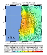
The 2007 Tocopilla earthquake was an earthquake
registered on November 14, 2007 at 15:40:53 UTC (12:40:53 local time). Its epicenter
was located between the localities of Quillagua
and Tocopilla
, affecting the Tarapacá
and the Antofagasta
regions in northern Chile
. The earthquake had a moment magnitude
of 7.7 and lasted about 3 minutes and 35 seconds. Seventeen aftershock
s of magnitude greater than 5.3, including one of magnitude 7.1 and two others of magnitude 6.3 or higher, were recorded. The Pacific Tsunami Warning Center
issued a tsunami
warning, stating a tsunami had been generated; after one hour, this warning was cancelled.
The earthquake was felt from Santiago
, 1,245 km south from the epicenter
, to La Paz
, about 700 km north-northeast.
reported that the earthquake resulted from the release of stresses generated by the subduction of the oceanic Nazca plate
beneath the South American Plate
. In this region, known as the Peru-Chile subduction
zone, the Nazca Plate thrusts beneath South America at a rate of approximately 79 mm/year in an east-north-east direction. This earthquake indicates subduction-related thrusting
, likely on the interface between these two plates.
This earthquake occurred near (and within) the southern end of the rupture area of the great magnitude 9.1 earthquake of 1877
, which produced a destructive tsunami and whose source region has since the late 1970’s been recognized as a potentially dangerous seismic gap
. In 1995, a magnitude 8.0 earthquake occurred in the same subduction zone approximately 200 km further south of the November 14th event.
 At least two deaths have been attributed to this earthquake, one being an 88-year old woman crushed under a collapsing wall at Tocopilla
, the other being a 54-year old woman, whose exact cause of death remains unknown. At least 150 were injured. There were also reports of widespread power outages in the region, including the cities of Antofagasta
, Calama
and Arica
. The earthquake disrupted copper mining in the region; because Chile is the world's top supplier of copper, the earthquake caused prices of the metal to jump by more than 6%. Tin
prices also rose 4% to reach a record high. There were reports of several dozens of road workers trapped inside a collapsed highway tunnel.
200 homes were destroyed by the shaking and up to 15,000 people were displaced. In Tocopilla alone, 1,000 homes were demolished, representing 30% of all standing structures.
Earthquake
An earthquake is the result of a sudden release of energy in the Earth's crust that creates seismic waves. The seismicity, seismism or seismic activity of an area refers to the frequency, type and size of earthquakes experienced over a period of time...
registered on November 14, 2007 at 15:40:53 UTC (12:40:53 local time). Its epicenter
Epicenter
The epicenter or epicentre is the point on the Earth's surface that is directly above the hypocenter or focus, the point where an earthquake or underground explosion originates...
was located between the localities of Quillagua
Quillagua
Quillagua is an oasis in the Tocopilla Province, in the Antofagasta Region of northern Chile. It is a part of the commune of María Elena. The Loa River is crossed by the Pan-American Highway in this area....
and Tocopilla
Tocopilla
Tocopilla is a city and commune in the Antofagasta Region, in the north of Chile. It is the capital of the province that bears the same name.Tocopilla celebrates its anniversary on September 29 every year with a big show the day before, which includes a parade down the main street of the city, food...
, affecting the Tarapacá
Tarapacá Region
The I Tarapacá Region is one of Chile's 15 first order administrative divisions. It borders the Chilean Arica and Parinacota Region to the north, Bolivia's Oruro Department on the east, the Antofagasta Region on the south and the Pacific Ocean on the west. The port city of Iquique The I Tarapacá...
and the Antofagasta
Antofagasta Region
The II Antofagasta Region is one of Chile's fifteen first-order administrative divisions. It comprises three provinces, Antofagasta, El Loa and Tocopilla...
regions in northern Chile
Chile
Chile ,officially the Republic of Chile , is a country in South America occupying a long, narrow coastal strip between the Andes mountains to the east and the Pacific Ocean to the west. It borders Peru to the north, Bolivia to the northeast, Argentina to the east, and the Drake Passage in the far...
. The earthquake had a moment magnitude
Moment magnitude scale
The moment magnitude scale is used by seismologists to measure the size of earthquakes in terms of the energy released. The magnitude is based on the seismic moment of the earthquake, which is equal to the rigidity of the Earth multiplied by the average amount of slip on the fault and the size of...
of 7.7 and lasted about 3 minutes and 35 seconds. Seventeen aftershock
Aftershock
An aftershock is a smaller earthquake that occurs after a previous large earthquake, in the same area of the main shock. If an aftershock is larger than the main shock, the aftershock is redesignated as the main shock and the original main shock is redesignated as a foreshock...
s of magnitude greater than 5.3, including one of magnitude 7.1 and two others of magnitude 6.3 or higher, were recorded. The Pacific Tsunami Warning Center
Pacific Tsunami Warning Center
The Pacific Tsunami Warning Center is one of two tsunami warning centers that are operated by NOAA in the United States. Headquartered in Ewa Beach, Hawaii, the PTWC is part of an international tsunami warning system program and serves as the operational center for TWS of the Pacific issuing...
issued a tsunami
Tsunami
A tsunami is a series of water waves caused by the displacement of a large volume of a body of water, typically an ocean or a large lake...
warning, stating a tsunami had been generated; after one hour, this warning was cancelled.
The earthquake was felt from Santiago
Santiago, Chile
Santiago , also known as Santiago de Chile, is the capital and largest city of Chile, and the center of its largest conurbation . It is located in the country's central valley, at an elevation of above mean sea level...
, 1,245 km south from the epicenter
Epicenter
The epicenter or epicentre is the point on the Earth's surface that is directly above the hypocenter or focus, the point where an earthquake or underground explosion originates...
, to La Paz
La Paz
Nuestra Señora de La Paz is the administrative capital of Bolivia, as well as the departmental capital of the La Paz Department, and the second largest city in the country after Santa Cruz de la Sierra...
, about 700 km north-northeast.
Tectonic summary
The USGSUnited States Geological Survey
The United States Geological Survey is a scientific agency of the United States government. The scientists of the USGS study the landscape of the United States, its natural resources, and the natural hazards that threaten it. The organization has four major science disciplines, concerning biology,...
reported that the earthquake resulted from the release of stresses generated by the subduction of the oceanic Nazca plate
Nazca Plate
]The Nazca Plate, named after the Nazca region of southern Peru, is an oceanic tectonic plate in the eastern Pacific Ocean basin off the west coast of South America. The ongoing subduction along the Peru-Chile Trench of the Nazca Plate under the South American Plate is largely responsible for the...
beneath the South American Plate
South American Plate
The South American Plate is a continental tectonic plate which includes the continent of South America and also a sizeable region of the Atlantic Ocean seabed extending eastward to the Mid-Atlantic Ridge....
. In this region, known as the Peru-Chile subduction
Subduction
In geology, subduction is the process that takes place at convergent boundaries by which one tectonic plate moves under another tectonic plate, sinking into the Earth's mantle, as the plates converge. These 3D regions of mantle downwellings are known as "Subduction Zones"...
zone, the Nazca Plate thrusts beneath South America at a rate of approximately 79 mm/year in an east-north-east direction. This earthquake indicates subduction-related thrusting
Thrust fault
A thrust fault is a type of fault, or break in the Earth's crust across which there has been relative movement, in which rocks of lower stratigraphic position are pushed up and over higher strata. They are often recognized because they place older rocks above younger...
, likely on the interface between these two plates.
This earthquake occurred near (and within) the southern end of the rupture area of the great magnitude 9.1 earthquake of 1877
1877 Iquique earthquake
The 1877 Iquique earthquake occurred at 21:16 local time on 9 May . It had a magnitude of 8.8 on the moment magnitude scale and a maximum felt intensity of XI on the Mercalli intensity scale and triggered a devastating tsunami...
, which produced a destructive tsunami and whose source region has since the late 1970’s been recognized as a potentially dangerous seismic gap
Seismic gap
A seismic gap is a segment of an active fault that has not slipped in an unusually long time when compared with other segments along the same structure. Seismic gap hypothesis/theory states that, over long periods of time, the displacement on any segment must be equal to that experienced by all...
. In 1995, a magnitude 8.0 earthquake occurred in the same subduction zone approximately 200 km further south of the November 14th event.
Damage and casualties
Tocopilla
Tocopilla is a city and commune in the Antofagasta Region, in the north of Chile. It is the capital of the province that bears the same name.Tocopilla celebrates its anniversary on September 29 every year with a big show the day before, which includes a parade down the main street of the city, food...
, the other being a 54-year old woman, whose exact cause of death remains unknown. At least 150 were injured. There were also reports of widespread power outages in the region, including the cities of Antofagasta
Antofagasta
Antofagasta is a port city in northern Chile, about north of Santiago. It is the capital of Antofagasta Province and Antofagasta Region. According to the 2002 census, the city has a population of 296,905...
, Calama
Calama, Chile
Calama is a city and commune in the Atacama Desert in northern Chile. It is the capital of El Loa Province, part of the Antofagasta Region. Calama is one of the driest cities in the world with average annual precipitation of just . The River Loa, Chile's longest, flows through the city...
and Arica
Arica, Chile
Arica is a commune and a port city with a population of 185,269 in the Arica Province of northern Chile's Arica and Parinacota Region, located only south of the border with Peru. The city is the capital of both the Arica Province and the Arica and Parinacota Region...
. The earthquake disrupted copper mining in the region; because Chile is the world's top supplier of copper, the earthquake caused prices of the metal to jump by more than 6%. Tin
Tin
Tin is a chemical element with the symbol Sn and atomic number 50. It is a main group metal in group 14 of the periodic table. Tin shows chemical similarity to both neighboring group 14 elements, germanium and lead and has two possible oxidation states, +2 and the slightly more stable +4...
prices also rose 4% to reach a record high. There were reports of several dozens of road workers trapped inside a collapsed highway tunnel.
200 homes were destroyed by the shaking and up to 15,000 people were displaced. In Tocopilla alone, 1,000 homes were demolished, representing 30% of all standing structures.
See also
- 2007 Peru earthquake2007 Peru earthquakeThe 2007 Peru earthquake was an earthquake measuring 8.0 on the moment magnitude scale that hit the central coast of Peru on Wednesday, August 15, 2007; it occurred at 23:40:57 UTC and lasted for about three minutes...
- 2007 Aysen Fjord earthquake
- Earthquakes in PeruEarthquakes in PeruEarthquakes in Peru are common occurrences as the country is located in a seismic zone. The interface between the Nazca and South American tectonic plates is located near the Peruvian coast. These plates are converging at a rate of per year...
- Great Chilean EarthquakeGreat Chilean EarthquakeThe 1960 Valdivia earthquake or Great Chilean Earthquake of Sunday, 22 May 1960 is to date the most powerful earthquake ever recorded on Earth, rating 9.5 on the moment magnitude scale...
- List of earthquakes in Chile
- Plate tectonicsPlate tectonicsPlate tectonics is a scientific theory that describes the large scale motions of Earth's lithosphere...
External links
- Oficina Nacional de Emergencia
- Report from the seismology service, University of Chile (in Spanish)