

Seismic gap
Encyclopedia
A seismic gap is a segment of an active fault
that has not slipped in an unusually long time when compared with other segments along the same structure. Seismic gap hypothesis/theory states that, over long periods of time, the displacement on any segment must be equal to that experienced by all the other parts of the fault. Any large and longstanding gap is therefore considered to be the fault segment most likely to suffer future earthquake
s.
The applicability of this approach has been criticised by some seismologists, although earthquakes have occurred in previously identified seismic gaps in some cases.
system recorded much less seismic activity than other parts of the fault. The main shock and aftershock
s of the 1989 event occurred within the previous seismic gap.
, a seismic gap analysis of the seismic zones around the Pacific Ocean identified the Central Kuril segment of the Kuril-Kamchatka Trench
subduction
zone as the most likely to give rise to a major earthquake. This zone, 500 km in length, at that time had experienced no major earthquake since 1780, but was bounded to north and south by segments that had moved within the last 100 years. The Mw
= 8.3 earthquake of 15 November 2006
and the Mw = 8.2 earthquake of 13 January 2007
occurred within the defined gap.
Active fault
An active fault is a fault that is likely to have another earthquake sometime in the future. Faults are commonly considered to be active if there has been movement observed or evidence of seismic activity during the last 10,000 years....
that has not slipped in an unusually long time when compared with other segments along the same structure. Seismic gap hypothesis/theory states that, over long periods of time, the displacement on any segment must be equal to that experienced by all the other parts of the fault. Any large and longstanding gap is therefore considered to be the fault segment most likely to suffer future earthquake
Earthquake
An earthquake is the result of a sudden release of energy in the Earth's crust that creates seismic waves. The seismicity, seismism or seismic activity of an area refers to the frequency, type and size of earthquakes experienced over a period of time...
s.
The applicability of this approach has been criticised by some seismologists, although earthquakes have occurred in previously identified seismic gaps in some cases.
Examples
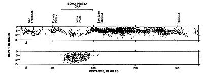
Loma Prieta Seismic Gap, California
Prior to the 1989 Loma Prieta earthquake, that segment of the San Andreas faultSan Andreas Fault
The San Andreas Fault is a continental strike-slip fault that runs a length of roughly through California in the United States. The fault's motion is right-lateral strike-slip...
system recorded much less seismic activity than other parts of the fault. The main shock and aftershock
Aftershock
An aftershock is a smaller earthquake that occurs after a previous large earthquake, in the same area of the main shock. If an aftershock is larger than the main shock, the aftershock is redesignated as the main shock and the original main shock is redesignated as a foreshock...
s of the 1989 event occurred within the previous seismic gap.
Central Kuril gap, Russia
Immediately following the 2004 Indian Ocean earthquake2004 Indian Ocean earthquake
The 2004 Indian Ocean earthquake was an undersea megathrust earthquake that occurred at 00:58:53 UTC on Sunday, December 26, 2004, with an epicentre off the west coast of Sumatra, Indonesia. The quake itself is known by the scientific community as the Sumatra-Andaman earthquake...
, a seismic gap analysis of the seismic zones around the Pacific Ocean identified the Central Kuril segment of the Kuril-Kamchatka Trench
Kuril-Kamchatka Trench
The Kuril–Kamchatka Trench or Kuril Trench is an oceanic trench in the northwest Pacific Ocean. It lies off the southeast coast of Kamchatka and parallels the Kuril Island chain to meet the Japan Trench east of Hokkaido...
subduction
Subduction
In geology, subduction is the process that takes place at convergent boundaries by which one tectonic plate moves under another tectonic plate, sinking into the Earth's mantle, as the plates converge. These 3D regions of mantle downwellings are known as "Subduction Zones"...
zone as the most likely to give rise to a major earthquake. This zone, 500 km in length, at that time had experienced no major earthquake since 1780, but was bounded to north and south by segments that had moved within the last 100 years. The Mw
Moment magnitude scale
The moment magnitude scale is used by seismologists to measure the size of earthquakes in terms of the energy released. The magnitude is based on the seismic moment of the earthquake, which is equal to the rigidity of the Earth multiplied by the average amount of slip on the fault and the size of...
= 8.3 earthquake of 15 November 2006
2006 Kuril Islands earthquake
The 2006 Kuril Islands earthquake was an 8.3 magnitude earthquake that hit the Kuril Islands at 11:14 UTC on November 15, 2006. A small tsunami hit the Japanese northern coast, with a larger wave following earlier small ones, due to reflection. The tsunami crossed the Pacific and did damage in...
and the Mw = 8.2 earthquake of 13 January 2007
2007 Kuril Islands earthquake
The 2007 Kuril Islands earthquake was a great earthquake that occurred east of the Kuril Islands on January 13, 2007 at 1:23 p.m. JST with a magnitude of 8.1 Mw. A tsunami warning was issued following the earthquake, and sea level gauges indicate that a tsunami was generated...
occurred within the defined gap.