
1921 Atlantic hurricane season
Encyclopedia
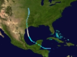
The 1921 Atlantic hurricane season ran through the summer and the first half of fall in 1921. The season was near average, with six tropical cyclones forming during the season.
into the southern Gulf of Mexico. The storm recurved towards the north, strengthening into a category 1
hurricane before it struck Sargent, Texas
. During the night of June 21, winds increased to 68 miles per hour (109.4 km/h) at Corpus Christi, Texas
. A barge with 18,000 gallons of oil sank in Port Aransas, Texas
. A storm surge
of 7.1 feet (2.2 m) was measured at Pass Cavallo
. As the cyclone
moved inland, it passed directly over Palacios, Texas
, Wharton, Texas
, and Wallis, Texas
. Winds gusted to 60 miles per hour (96.6 km/h) at both Galveston, Texas
and Houston, Texas
. Heavy rains accompanied the system, with 10.1 inches (256.5 mm) recorded at Matagorda, Texas
.
, a new 18-hour rainfall record was set for the United States
as 36.4 inches (924.6 mm) was recorded. The deluge led to one of the most destructive floods in the history of San Antonio, Texas
. Water rose to 7 feet (2.1 m) deep in the city, forcing people to evacuate vertically within taller buildings. The most significant river floods occurred on the Little
and San Gabriel river
s, where 159 people perished. Combined with the death toll from elsewhere across the region, 215 people died due to this storm and damages were estimated at $19 million (1921 USD).
struck Hispaniola
and grazed Bermuda
.
to just southwest of the Azores
. It was later determined that it was extratropical for most of the journey.
on October 20. It tracked north-northwestward, steadily strengthening into a hurricane on October 22. The storm turned more north-northeastward, and upon reaching the Gulf of Mexico on October 24 it rapidly intensified to a 140 mph Category 4. It weakened as it continued to the northeast, making landfall north of Clearwater
on October 25 as a Category 3 hurricane. It crossed Florida
, turned eastward across the Atlantic, and became extratropical on October 28 southwest of Bermuda. Its small and quick nature, as well as well-executed warnings, only caused $3 million in damage (1921 USD), with 6 casualties.
Hurricane One
A tropical storm formed in the western Caribbean before moving across the Yucatan peninsulaYucatán Peninsula
The Yucatán Peninsula, in southeastern Mexico, separates the Caribbean Sea from the Gulf of Mexico, with the northern coastline on the Yucatán Channel...
into the southern Gulf of Mexico. The storm recurved towards the north, strengthening into a category 1
Saffir-Simpson Hurricane Scale
The Saffir–Simpson Hurricane Scale , or the Saffir–Simpson Hurricane Wind Scale , classifies hurricanes — Western Hemisphere tropical cyclones that exceed the intensities of tropical depressions and tropical storms — into five categories distinguished by the intensities of their sustained winds...
hurricane before it struck Sargent, Texas
Sargent, Texas
Sargent is a small unincorporated community located in the eastern corner of Matagorda County, Texas, United States.Sargent is a fishing, boating, and water sports community with a variable population, as most of its inhabitants are weekend commuters from larger cities such as Houston, Austin, and...
. During the night of June 21, winds increased to 68 miles per hour (109.4 km/h) at Corpus Christi, Texas
Corpus Christi, Texas
Corpus Christi is a coastal city in the South Texas region of the U.S. state of Texas. The county seat of Nueces County, it also extends into Aransas, Kleberg, and San Patricio counties. The MSA population in 2008 was 416,376. The population was 305,215 at the 2010 census making it the...
. A barge with 18,000 gallons of oil sank in Port Aransas, Texas
Port Aransas, Texas
Port Aransas is a city in Nueces County, Texas. The population was 3,370 at the 2000 census.-Early history:Karankawa Indians played a key role in the early development of the Texas Gulf Coast. The Karankawa Indians inhabited the Gulf Coast of Texas from Galveston Bay all the way to Corpus Christi Bay...
. A storm surge
Storm surge
A storm surge is an offshore rise of water associated with a low pressure weather system, typically tropical cyclones and strong extratropical cyclones. Storm surges are caused primarily by high winds pushing on the ocean's surface. The wind causes the water to pile up higher than the ordinary sea...
of 7.1 feet (2.2 m) was measured at Pass Cavallo
Pass Cavallo (Texas)
Pass Cavallo, alternately known as Cavallo Pass, is one of five natural water inlets which separate the Gulf of Mexico and Matagorda Bay, in the U.S. state of Texas. René-Robert Cavelier, Sieur de La Salle came ashore in Texas at this point. Matagorda Island Lighthouse was originally built on...
. As the cyclone
Cyclone
In meteorology, a cyclone is an area of closed, circular fluid motion rotating in the same direction as the Earth. This is usually characterized by inward spiraling winds that rotate anticlockwise in the Northern Hemisphere and clockwise in the Southern Hemisphere of the Earth. Most large-scale...
moved inland, it passed directly over Palacios, Texas
Palacios, Texas
-Demographics:As of the census of 2000, there were 5,153 people, 1,661 households, and 1,244 families residing in the city. The population density was 1,021.4 people per square mile . There were 1,976 housing units at an average density of 391.7 per square mile...
, Wharton, Texas
Wharton, Texas
Wharton is a city in Wharton County, Texas, United States. The population was 9,237 at the 2000 census. It is the county seat of Wharton County and is located on the Colorado River of Texas just south of U.S...
, and Wallis, Texas
Wallis, Texas
Wallis is a city in Austin County, Texas, United States. The population was 1,172 at the 2000 census.-Geography:Wallis is located at ....
. Winds gusted to 60 miles per hour (96.6 km/h) at both Galveston, Texas
Galveston, Texas
Galveston is a coastal city located on Galveston Island in the U.S. state of Texas. , the city had a total population of 47,743 within an area of...
and Houston, Texas
Houston, Texas
Houston is the fourth-largest city in the United States, and the largest city in the state of Texas. According to the 2010 U.S. Census, the city had a population of 2.1 million people within an area of . Houston is the seat of Harris County and the economic center of , which is the ...
. Heavy rains accompanied the system, with 10.1 inches (256.5 mm) recorded at Matagorda, Texas
Matagorda, Texas
Matagorda is an unincorporated community in Matagorda County, Texas, United States. It had a population of approximately 710 in 2000. Matagorda is at the end of State Highway 60 and beginning of Farm to Market Road 2031, which runs over the Intracoastal Waterway and south to the Gulf of Mexico...
.
Hurricane Two
A category 1 struck Tampico, Mexico in early September after moving northwest from the Gulf of Mexico. After it dissipated on September 8, an extremely heavy rainfall event ensued across central Texas, which continued into September 11. In Williamson County, TexasWilliamson County, Texas
Williamson County is a county located on both the Edwards Plateau to the west, consisting of rocky terrain and hills, and Blackland Prairies in the east consising of rich, fertile farming land, The two areas are roughly bisected by Interstate 35...
, a new 18-hour rainfall record was set for the United States
United States
The United States of America is a federal constitutional republic comprising fifty states and a federal district...
as 36.4 inches (924.6 mm) was recorded. The deluge led to one of the most destructive floods in the history of San Antonio, Texas
San Antonio, Texas
San Antonio is the seventh-largest city in the United States of America and the second-largest city within the state of Texas, with a population of 1.33 million. Located in the American Southwest and the south–central part of Texas, the city serves as the seat of Bexar County. In 2011,...
. Water rose to 7 feet (2.1 m) deep in the city, forcing people to evacuate vertically within taller buildings. The most significant river floods occurred on the Little
Little River (Texas)
The Little River is a river in the U.S. state of Texas. It is formed by the confluence of the Leon River and the Lampasas River near Little River, Texas. It flows generally southeast for seventy-five miles until it empties into the Brazos River near Port Sulllivan....
and San Gabriel river
San Gabriel River (Texas)
The San Gabriel River is a river that flows through central Texas. The San Gabriel River is formed in Georgetown, Texas by the confluence of the North Fork San Gabriel and the South Fork San Gabriel, both of which originate in Burnet County. There are two major impoundments of the river: Lake...
s, where 159 people perished. Combined with the death toll from elsewhere across the region, 215 people died due to this storm and damages were estimated at $19 million (1921 USD).
Hurricane Three
A Category 2Saffir-Simpson Hurricane Scale
The Saffir–Simpson Hurricane Scale , or the Saffir–Simpson Hurricane Wind Scale , classifies hurricanes — Western Hemisphere tropical cyclones that exceed the intensities of tropical depressions and tropical storms — into five categories distinguished by the intensities of their sustained winds...
struck Hispaniola
Hispaniola
Hispaniola is a major island in the Caribbean, containing the two sovereign states of the Dominican Republic and Haiti. The island is located between the islands of Cuba to the west and Puerto Rico to the east, within the hurricane belt...
and grazed Bermuda
Bermuda
Bermuda is a British overseas territory in the North Atlantic Ocean. Located off the east coast of the United States, its nearest landmass is Cape Hatteras, North Carolina, about to the west-northwest. It is about south of Halifax, Nova Scotia, Canada, and northeast of Miami, Florida...
.
Hurricane Four
A category 1 formed in the Atlantic and never approached land. It dissipated on September 14.Tropical Storm Five
Another notable system was a tropical storm that made a transatlantic journey from off the coast of South CarolinaSouth Carolina
South Carolina is a state in the Deep South of the United States that borders Georgia to the south, North Carolina to the north, and the Atlantic Ocean to the east. Originally part of the Province of Carolina, the Province of South Carolina was one of the 13 colonies that declared independence...
to just southwest of the Azores
Azores
The Archipelago of the Azores is composed of nine volcanic islands situated in the middle of the North Atlantic Ocean, and is located about west from Lisbon and about east from the east coast of North America. The islands, and their economic exclusion zone, form the Autonomous Region of the...
. It was later determined that it was extratropical for most of the journey.
Hurricane Six
The most notable storm of the season, was the Tampa Bay Hurricane of 1921. It developed in the southwestern Caribbean SeaCaribbean Sea
The Caribbean Sea is a sea of the Atlantic Ocean located in the tropics of the Western hemisphere. It is bounded by Mexico and Central America to the west and southwest, to the north by the Greater Antilles, and to the east by the Lesser Antilles....
on October 20. It tracked north-northwestward, steadily strengthening into a hurricane on October 22. The storm turned more north-northeastward, and upon reaching the Gulf of Mexico on October 24 it rapidly intensified to a 140 mph Category 4. It weakened as it continued to the northeast, making landfall north of Clearwater
Clearwater, Florida
Clearwater is a city located in Pinellas County, Florida, US, nearly due west of Tampa and northwest of St. Petersburg. In the west of Clearwater lies the Gulf of Mexico and in the east lies Tampa Bay. As of the 2000 census, the city had a total population of 108,787. It is the county seat of...
on October 25 as a Category 3 hurricane. It crossed Florida
Florida
Florida is a state in the southeastern United States, located on the nation's Atlantic and Gulf coasts. It is bordered to the west by the Gulf of Mexico, to the north by Alabama and Georgia and to the east by the Atlantic Ocean. With a population of 18,801,310 as measured by the 2010 census, it...
, turned eastward across the Atlantic, and became extratropical on October 28 southwest of Bermuda. Its small and quick nature, as well as well-executed warnings, only caused $3 million in damage (1921 USD), with 6 casualties.
Tropical Storm Seven
Tropical Storm Seven formed on November 19. It made landfall in Cuba before dissipating on November 25.See also
- List of tropical cyclones
- List of Atlantic hurricane seasons