
1916 Texas Hurricane
Encyclopedia
The 1916 Texas Hurricane was a Category 4 hurricane
that struck the southern Texas
(the landfall was south of Corpus Christi, Texas
) coast in mid August 1916. The hurricane was the fourth hurricane and third major hurricane of an active 1916 Atlantic hurricane season
. Forming on August 12, the storm crossed the Leeward Islands
and Caribbean Sea
before hitting south Texas
on August 18. The 1916 storm was the strongest hurricane to hit the Texas coast since the Galveston Hurricane of 1900
, and the hurricane caused 24 fatalities and left millions of dollars in damage. The hurricane was also one of three hurricane to hit the Caribbean Island of Martinique
during the 1916 season.
and moved westward. At 1800 UTC, the storm rapidly reached hurricane strength before crossing over the Leeward Islands on the same day. On August 14, the hurricane then reached Category 2
strength as it moved west-northwest through the Caribbean sea. On the evening of August 15, the hurricane made landfall in Jamaica
as a 105 mph (169 km/h) hurricane. Despite the landfall, however, the storm did not weaken as it winds strengthened to 110 mph (177 km/h). As the storm moved west-northwest, the storm reached Category 3
status as it passed over the Cayman Islands
on August 16. As the storm approached the western tip of Cuba
, it veered slightly southwestward and brushed the north tip of the Yucatán Peninsula
, thus sparing western Cuba
of a direct landfall. The hurricane made landfall on August 19 south of Corpus Christi, Texas
as a Category 4 hurricane. After making landfall, the hurricane quickly weakened to a tropical storm and later to a tropical depression before dissipating.
and Calhoun
counties. Over 100 vehicles were used to transport residents to storm shelters.
 The Island of Martinique
was brushed by the hurricane. In Jamaica
, the hurricane left 17 people dead and 25-27 million dollars (1916 USD) in damage.
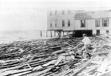
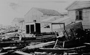
In Texas
, tropical storm force winds of 64-70 mph were felt as the hurricane neared land. A gust of 90 mi/h was reported at 6:50 pm (CST) as the hurricane made landfall. Rainfall totals from the hurricane was estimated at 1.58 inches (25.4 mm). The hurricane damaged some of the measuring equipment at the National Weather Service office. Offshore, a fishing boat sank, drowning two of its occupants. On land, five people perished during the storm; two from a house collapsing. In Corpus Christi
, the hurricane destroyed several wharfs and salt cedars. In Fort Brown
, the flooding from the hurricane forced United States Army
soldiers and National Guardsmen to seek refuge in city hall after their barracks were flooded. The storm left $1.6 million dollars (1916 USD) in damage in Texas
. In all the hurricane left $28.6 million dollars (1916 USD, $521.7 million (2005 USD) and 24 people dead.
Saffir-Simpson Hurricane Scale
The Saffir–Simpson Hurricane Scale , or the Saffir–Simpson Hurricane Wind Scale , classifies hurricanes — Western Hemisphere tropical cyclones that exceed the intensities of tropical depressions and tropical storms — into five categories distinguished by the intensities of their sustained winds...
that struck the southern Texas
Texas
Texas is the second largest U.S. state by both area and population, and the largest state by area in the contiguous United States.The name, based on the Caddo word "Tejas" meaning "friends" or "allies", was applied by the Spanish to the Caddo themselves and to the region of their settlement in...
(the landfall was south of Corpus Christi, Texas
Corpus Christi, Texas
Corpus Christi is a coastal city in the South Texas region of the U.S. state of Texas. The county seat of Nueces County, it also extends into Aransas, Kleberg, and San Patricio counties. The MSA population in 2008 was 416,376. The population was 305,215 at the 2010 census making it the...
) coast in mid August 1916. The hurricane was the fourth hurricane and third major hurricane of an active 1916 Atlantic hurricane season
1916 Atlantic hurricane season
The 1916 Atlantic hurricane season ran through the summer and the first half of fall in 1916. The season is one of only two in which two major hurricanes were reported before the month of August, the other being the 2005 season.-Storms:...
. Forming on August 12, the storm crossed the Leeward Islands
Leeward Islands
The Leeward Islands are a group of islands in the West Indies. They are the northern islands of the Lesser Antilles chain. As a group they start east of Puerto Rico and reach southward to Dominica. They are situated where the northeastern Caribbean Sea meets the western Atlantic Ocean...
and Caribbean Sea
Caribbean Sea
The Caribbean Sea is a sea of the Atlantic Ocean located in the tropics of the Western hemisphere. It is bounded by Mexico and Central America to the west and southwest, to the north by the Greater Antilles, and to the east by the Lesser Antilles....
before hitting south Texas
Texas
Texas is the second largest U.S. state by both area and population, and the largest state by area in the contiguous United States.The name, based on the Caddo word "Tejas" meaning "friends" or "allies", was applied by the Spanish to the Caddo themselves and to the region of their settlement in...
on August 18. The 1916 storm was the strongest hurricane to hit the Texas coast since the Galveston Hurricane of 1900
Galveston Hurricane of 1900
The Hurricane of 1900 made landfall on the city of Galveston in the U.S. state of Texas, on September 8, 1900.It had estimated winds of at landfall, making it a Category 4 storm on the Saffir-Simpson Hurricane Scale...
, and the hurricane caused 24 fatalities and left millions of dollars in damage. The hurricane was also one of three hurricane to hit the Caribbean Island of Martinique
Martinique
Martinique is an island in the eastern Caribbean Sea, with a land area of . Like Guadeloupe, it is an overseas region of France, consisting of a single overseas department. To the northwest lies Dominica, to the south St Lucia, and to the southeast Barbados...
during the 1916 season.
Meteorological history
On August 12, a tropical storm formed east of the Leeward IslandsLeeward Islands
The Leeward Islands are a group of islands in the West Indies. They are the northern islands of the Lesser Antilles chain. As a group they start east of Puerto Rico and reach southward to Dominica. They are situated where the northeastern Caribbean Sea meets the western Atlantic Ocean...
and moved westward. At 1800 UTC, the storm rapidly reached hurricane strength before crossing over the Leeward Islands on the same day. On August 14, the hurricane then reached Category 2
Saffir-Simpson Hurricane Scale
The Saffir–Simpson Hurricane Scale , or the Saffir–Simpson Hurricane Wind Scale , classifies hurricanes — Western Hemisphere tropical cyclones that exceed the intensities of tropical depressions and tropical storms — into five categories distinguished by the intensities of their sustained winds...
strength as it moved west-northwest through the Caribbean sea. On the evening of August 15, the hurricane made landfall in Jamaica
Jamaica
Jamaica is an island nation of the Greater Antilles, in length, up to in width and 10,990 square kilometres in area. It is situated in the Caribbean Sea, about south of Cuba, and west of Hispaniola, the island harbouring the nation-states Haiti and the Dominican Republic...
as a 105 mph (169 km/h) hurricane. Despite the landfall, however, the storm did not weaken as it winds strengthened to 110 mph (177 km/h). As the storm moved west-northwest, the storm reached Category 3
Saffir-Simpson Hurricane Scale
The Saffir–Simpson Hurricane Scale , or the Saffir–Simpson Hurricane Wind Scale , classifies hurricanes — Western Hemisphere tropical cyclones that exceed the intensities of tropical depressions and tropical storms — into five categories distinguished by the intensities of their sustained winds...
status as it passed over the Cayman Islands
Cayman Islands
The Cayman Islands is a British Overseas Territory and overseas territory of the European Union located in the western Caribbean Sea. The territory comprises the three islands of Grand Cayman, Cayman Brac, and Little Cayman, located south of Cuba and northwest of Jamaica...
on August 16. As the storm approached the western tip of Cuba
Cuba
The Republic of Cuba is an island nation in the Caribbean. The nation of Cuba consists of the main island of Cuba, the Isla de la Juventud, and several archipelagos. Havana is the largest city in Cuba and the country's capital. Santiago de Cuba is the second largest city...
, it veered slightly southwestward and brushed the north tip of the Yucatán Peninsula
Yucatán Peninsula
The Yucatán Peninsula, in southeastern Mexico, separates the Caribbean Sea from the Gulf of Mexico, with the northern coastline on the Yucatán Channel...
, thus sparing western Cuba
Cuba
The Republic of Cuba is an island nation in the Caribbean. The nation of Cuba consists of the main island of Cuba, the Isla de la Juventud, and several archipelagos. Havana is the largest city in Cuba and the country's capital. Santiago de Cuba is the second largest city...
of a direct landfall. The hurricane made landfall on August 19 south of Corpus Christi, Texas
Corpus Christi, Texas
Corpus Christi is a coastal city in the South Texas region of the U.S. state of Texas. The county seat of Nueces County, it also extends into Aransas, Kleberg, and San Patricio counties. The MSA population in 2008 was 416,376. The population was 305,215 at the 2010 census making it the...
as a Category 4 hurricane. After making landfall, the hurricane quickly weakened to a tropical storm and later to a tropical depression before dissipating.
Preparations
At 7 am (CST), local weather officials issued hurricane warnings to coastal sections. Telegraphs of the warnings were then sent out to CameronCameron County, Texas
Cameron County is the southernmost county located in the U.S. state of Texas. In 2010, its population was 406,220. Its county seat is Brownsville. Cameron was founded in 1848...
and Calhoun
Calhoun County, Texas
Calhoun County is a county located in the U.S. state of Texas. In 2000, the population was 20,647. Its county seat is Port Lavaca. It is a part of the Victoria Metropolitan Statistical Area...
counties. Over 100 vehicles were used to transport residents to storm shelters.
Impact
Martinique
Martinique is an island in the eastern Caribbean Sea, with a land area of . Like Guadeloupe, it is an overseas region of France, consisting of a single overseas department. To the northwest lies Dominica, to the south St Lucia, and to the southeast Barbados...
was brushed by the hurricane. In Jamaica
Jamaica
Jamaica is an island nation of the Greater Antilles, in length, up to in width and 10,990 square kilometres in area. It is situated in the Caribbean Sea, about south of Cuba, and west of Hispaniola, the island harbouring the nation-states Haiti and the Dominican Republic...
, the hurricane left 17 people dead and 25-27 million dollars (1916 USD) in damage.
In Texas
Texas
Texas is the second largest U.S. state by both area and population, and the largest state by area in the contiguous United States.The name, based on the Caddo word "Tejas" meaning "friends" or "allies", was applied by the Spanish to the Caddo themselves and to the region of their settlement in...
, tropical storm force winds of 64-70 mph were felt as the hurricane neared land. A gust of 90 mi/h was reported at 6:50 pm (CST) as the hurricane made landfall. Rainfall totals from the hurricane was estimated at 1.58 inches (25.4 mm). The hurricane damaged some of the measuring equipment at the National Weather Service office. Offshore, a fishing boat sank, drowning two of its occupants. On land, five people perished during the storm; two from a house collapsing. In Corpus Christi
Corpus Christi, Texas
Corpus Christi is a coastal city in the South Texas region of the U.S. state of Texas. The county seat of Nueces County, it also extends into Aransas, Kleberg, and San Patricio counties. The MSA population in 2008 was 416,376. The population was 305,215 at the 2010 census making it the...
, the hurricane destroyed several wharfs and salt cedars. In Fort Brown
Fort Brown
Fort Brown was a military post of the United States Army in Texas during the later half of 19th century and the early part of the 20th century.-Early years:...
, the flooding from the hurricane forced United States Army
United States Army
The United States Army is the main branch of the United States Armed Forces responsible for land-based military operations. It is the largest and oldest established branch of the U.S. military, and is one of seven U.S. uniformed services...
soldiers and National Guardsmen to seek refuge in city hall after their barracks were flooded. The storm left $1.6 million dollars (1916 USD) in damage in Texas
Texas
Texas is the second largest U.S. state by both area and population, and the largest state by area in the contiguous United States.The name, based on the Caddo word "Tejas" meaning "friends" or "allies", was applied by the Spanish to the Caddo themselves and to the region of their settlement in...
. In all the hurricane left $28.6 million dollars (1916 USD, $521.7 million (2005 USD) and 24 people dead.
See also
- Tropical cycloneTropical cycloneA tropical cyclone is a storm system characterized by a large low-pressure center and numerous thunderstorms that produce strong winds and heavy rain. Tropical cyclones strengthen when water evaporated from the ocean is released as the saturated air rises, resulting in condensation of water vapor...