
1895 Atlantic hurricane season
Encyclopedia
The 1895 Atlantic hurricane season ran through the summer and the first half of fall in 1895. The season was a fairly inactive one, with 6 storms forming, only 2 of which became hurricanes.
and moved north, making landfall in Alabama
. Its maximum sustained winds were at 60 mi/h.
and skimmed the Yucatán Peninsula
but did not hit it, and made landfall in the southernmost part of Texas
. Its maximum sustained winds were at 110 mi/h.
, then went through the Bahamas. Its maximum sustained winds were at 55 mph (89 km/h). This storm was responsible for an estimated 56 deaths.
as a tropical storm. After passing through the Windwards, it reached hurricane status and eventually strengthened to a Category 2 as it moved westward through the southern Caribbean Sea. Reaching its peak of 105 mi/h, the storm then curved northward and eventually northeast, hitting Cuba
and the Bahamas before moving out to sea.
and curving east-northeast past the tip of the Yucatán Peninsula
and making landfall in southwest Florida
. It weakened to a depression after moving inland and crossing the southern half of the state, finally dissipating off the southeast Florida coast near the Bahamas.
Tropical Storm One
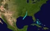
The first storm formed on August 14 and lasted until August 17. It formed in the Gulf of MexicoGulf of Mexico
The Gulf of Mexico is a partially landlocked ocean basin largely surrounded by the North American continent and the island of Cuba. It is bounded on the northeast, north and northwest by the Gulf Coast of the United States, on the southwest and south by Mexico, and on the southeast by Cuba. In...
and moved north, making landfall in Alabama
Alabama
Alabama is a state located in the southeastern region of the United States. It is bordered by Tennessee to the north, Georgia to the east, Florida and the Gulf of Mexico to the south, and Mississippi to the west. Alabama ranks 30th in total land area and ranks second in the size of its inland...
. Its maximum sustained winds were at 60 mi/h.
Hurricane Two
The second storm formed on August 22 and lasted until August 29. It formed directly to the east of the Lesser AntillesLesser Antilles
The Lesser Antilles are a long, partly volcanic island arc in the Western Hemisphere. Most of its islands form the eastern boundary of the Caribbean Sea with the Atlantic Ocean, with the remainder located in the southern Caribbean just north of South America...
and skimmed the Yucatán Peninsula
Yucatán Peninsula
The Yucatán Peninsula, in southeastern Mexico, separates the Caribbean Sea from the Gulf of Mexico, with the northern coastline on the Yucatán Channel...
but did not hit it, and made landfall in the southernmost part of Texas
Texas
Texas is the second largest U.S. state by both area and population, and the largest state by area in the contiguous United States.The name, based on the Caddo word "Tejas" meaning "friends" or "allies", was applied by the Spanish to the Caddo themselves and to the region of their settlement in...
. Its maximum sustained winds were at 110 mi/h.
Tropical Storm Three
The third storm formed on September 28 and lasted until October 7. It formed right on the east of the Yucatán Peninsula. It hit the Yucatán then curved over and under FloridaFlorida
Florida is a state in the southeastern United States, located on the nation's Atlantic and Gulf coasts. It is bordered to the west by the Gulf of Mexico, to the north by Alabama and Georgia and to the east by the Atlantic Ocean. With a population of 18,801,310 as measured by the 2010 census, it...
, then went through the Bahamas. Its maximum sustained winds were at 55 mph (89 km/h). This storm was responsible for an estimated 56 deaths.
Tropical Storm Four
The fourth tropical storm probably formed on 2 October 1895 in the western Caribbean Sea. It apparently crossed the Yucatán Peninsula on 3/4 October, just a few days after tropical storm 3 struck the same area. It peaked as a minimal tropical storm with wind of 35 knots. This cyclone moved into Texas and Louisiana on 7 October 1895, producing breezy conditions and some rain.Hurricane Five
The fifth storm formed on October 12 and lasted until October 26. It formed to the east of the southern Lesser Antilles and Windward IslandsWindward Islands
The Windward Islands are the southern islands of the Lesser Antilles, within the West Indies.-Name and geography:The Windward Islands are called such because they were more windward to sailing ships arriving in the New World than the Leeward Islands, given that the prevailing trade winds in the...
as a tropical storm. After passing through the Windwards, it reached hurricane status and eventually strengthened to a Category 2 as it moved westward through the southern Caribbean Sea. Reaching its peak of 105 mi/h, the storm then curved northward and eventually northeast, hitting Cuba
Cuba
The Republic of Cuba is an island nation in the Caribbean. The nation of Cuba consists of the main island of Cuba, the Isla de la Juventud, and several archipelagos. Havana is the largest city in Cuba and the country's capital. Santiago de Cuba is the second largest city...
and the Bahamas before moving out to sea.
Tropical Storm Six
The final storm formed on October 13 and lasted until October 17. The storm was fairly short-lived and mostly maintained its peak intensity as a minimal 40 mi/h tropical storm, forming in the Bay of CampecheBay of Campeche
The Bay of Campeche is the southern bight of the Gulf of Mexico. It is surrounded on three sides by the Mexican states of Campeche, Tabasco and Veracruz. It was named by Francisco Hernández de Córdoba and Antonio de Alaminos during their expedition in 1517...
and curving east-northeast past the tip of the Yucatán Peninsula
Yucatán Peninsula
The Yucatán Peninsula, in southeastern Mexico, separates the Caribbean Sea from the Gulf of Mexico, with the northern coastline on the Yucatán Channel...
and making landfall in southwest Florida
Florida
Florida is a state in the southeastern United States, located on the nation's Atlantic and Gulf coasts. It is bordered to the west by the Gulf of Mexico, to the north by Alabama and Georgia and to the east by the Atlantic Ocean. With a population of 18,801,310 as measured by the 2010 census, it...
. It weakened to a depression after moving inland and crossing the southern half of the state, finally dissipating off the southeast Florida coast near the Bahamas.
See also
- List of tropical cyclones
- List of Atlantic hurricane seasons