

17 Avenue SW, Calgary
Encyclopedia
17 Avenue SW is a major east-west arterial road
in the south-west quadrant of the city of Calgary
, Alberta
, Canada
.
Between the Calgary Stampede
Grounds and 14 Street SW, it is a commercial street, with bars, restaurants, nightclubs, and shops, which has been designated a Business Revitalization Zones. It carries the banner "Uptown 17th" on this portion. From 14th Street to Sarcee Trail, it is flanked by a mix of residential and commercial space, with small strip mall
s and denser commercial developments in the Westbrook Mall area. West of Sarcee Trail it runs through suburb
an neighbourhoods and acreages, by Rundle College
and Westside Recreation Centre.
The west extension of the C-Train
light rail transit
system (under construction as of 2009) runs along 17 Avenue west of 33 Street SW, as does the rapid bus transit.
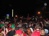
With a dense concentration of bars, restaurants, nightclubs, and shops, the street is effectively Calgary's primary "party street". Behind this lively commercial development are residential areas. The street also "dead-ends" at the Stampede Grounds on its east side, and is thus central to the party-like atmosphere that overtakes the city during the Calgary Stampede
festival. 17th Avenue was nicknamed the "Red Mile
" in 2004 during the playoff run of Calgary's NHL
team, the Calgary Flames
. During this time, it was not uncommon to see over 100,000 fans crowding the street and its bars and pubs on game nights.
Arterial road
An arterial road, or arterial thoroughfare, is a high-capacity urban road. The primary function of an arterial road is to deliver traffic from collector roads to freeways, and between urban centres at the highest level of service possible. As such, many arteries are limited-access roads, or feature...
in the south-west quadrant of the city of Calgary
Calgary
Calgary is a city in the Province of Alberta, Canada. It is located in the south of the province, in an area of foothills and prairie, approximately east of the front ranges of the Canadian Rockies...
, Alberta
Alberta
Alberta is a province of Canada. It had an estimated population of 3.7 million in 2010 making it the most populous of Canada's three prairie provinces...
, Canada
Canada
Canada is a North American country consisting of ten provinces and three territories. Located in the northern part of the continent, it extends from the Atlantic Ocean in the east to the Pacific Ocean in the west, and northward into the Arctic Ocean...
.
Between the Calgary Stampede
Calgary Stampede
The Calgary Stampede is an annual rodeo, exhibition and festival held every July in Calgary, Alberta, Canada. The ten-day event, which bills itself as "The Greatest Outdoor Show on Earth", attracts over one million visitors per year and features one of the world's largest rodeos, a parade, midway,...
Grounds and 14 Street SW, it is a commercial street, with bars, restaurants, nightclubs, and shops, which has been designated a Business Revitalization Zones. It carries the banner "Uptown 17th" on this portion. From 14th Street to Sarcee Trail, it is flanked by a mix of residential and commercial space, with small strip mall
Strip mall
A strip mall is an open-area shopping center where the stores are arranged in a row, with a sidewalk in front. Strip malls are typically developed as a unit and have large parking lots in front...
s and denser commercial developments in the Westbrook Mall area. West of Sarcee Trail it runs through suburb
Suburb
The word suburb mostly refers to a residential area, either existing as part of a city or as a separate residential community within commuting distance of a city . Some suburbs have a degree of administrative autonomy, and most have lower population density than inner city neighborhoods...
an neighbourhoods and acreages, by Rundle College
Rundle College Society
Rundle College Society is a not for profit organization operating five schools in Calgary, Alberta. -History:Rundle College was founded in 1985 and provides education for approximately 900 students in pre-school through Grade 12. In addition to academic achievement, Rundle's programs emphasize...
and Westside Recreation Centre.
The west extension of the C-Train
C-Train
C-Train is the light rail transit system in Calgary, Alberta, Canada. It has been in operation since May 25, 1981. The system is operated by Calgary Transit, a department of the Calgary municipal government.-Operations:...
light rail transit
Light Rail Transit
The name Light Rail Transit is used to refer to several light rail systems, as an official name or otherwise:* Please see List of tram and light-rail transit systems.-See also:* Light Rapid Transit * Light railway* Light rail...
system (under construction as of 2009) runs along 17 Avenue west of 33 Street SW, as does the rapid bus transit.
Red Mile
With a dense concentration of bars, restaurants, nightclubs, and shops, the street is effectively Calgary's primary "party street". Behind this lively commercial development are residential areas. The street also "dead-ends" at the Stampede Grounds on its east side, and is thus central to the party-like atmosphere that overtakes the city during the Calgary Stampede
Calgary Stampede
The Calgary Stampede is an annual rodeo, exhibition and festival held every July in Calgary, Alberta, Canada. The ten-day event, which bills itself as "The Greatest Outdoor Show on Earth", attracts over one million visitors per year and features one of the world's largest rodeos, a parade, midway,...
festival. 17th Avenue was nicknamed the "Red Mile
Red Mile
The Red Mile is the name given to a several-block stretch of 17th Avenue S.W. in Calgary, Alberta, Canada during the Calgary Flames 2004 Stanley Cup playoff run...
" in 2004 during the playoff run of Calgary's NHL
National Hockey League
The National Hockey League is an unincorporated not-for-profit association which operates a major professional ice hockey league of 30 franchised member clubs, of which 7 are currently located in Canada and 23 in the United States...
team, the Calgary Flames
Calgary Flames
The Calgary Flames are a professional ice hockey team based in Calgary, Alberta, Canada. They are members of the Northwest Division of the Western Conference of the National Hockey League . The club is the third major-professional ice hockey team to represent the city of Calgary, following the...
. During this time, it was not uncommon to see over 100,000 fans crowding the street and its bars and pubs on game nights.
Major intersections
- 0 km - starts at Macleod Trail (northbound) - 51.03785°N 114.05864°W
- 2.5 km - quadrant intersection with 14 Street SW - 51.03785°N 114.09456°W
- 3.8 km - interchange with Crowchild TrailCrowchild TrailCrowchild Trail is an expressway located on the west side of Calgary, Alberta, Canada.The road was originally signed as 24th Street SW from North Glenmore Park to the Bow River, 24th Street NW from the Bow to the intersection with 16th Avenue NW , and Highway 1A from 16th Ave NW to the city limits...
, via Richmond Road and 24th Street SW- 51.03789°N 114.11306°W - 5.8 km - quadrant intersection with 37 Street SW - 51.03780°N 114.14117°W
- 7.5 km - diamond intersection with Sarcee TrailSarcee TrailSarcee Trail is a major urban arterial road in Calgary, Alberta. It is divided into two portions, one in the north end of the city, and one in the south end of the city. Originally planned as one continuous route, plans to connect the two halves have been shelved...
- 51.03991°N 114.16413°W - 9.2 km - diamond intersection with 69 Street SW - 51.03767°N 114.18747°W
- 10.9 km - quadrant intersection with 85 Street SW - 51.03785°N 114.21095°W
- 12.5 km - Calgary city limits at 101 Street SW, continues as Township Road 242 - 51.03785°N 114.23434°W