
Água Fria de Goiás
Encyclopedia
| Água Fria de Goiás | |
|---|---|
| State | Goiás Goiás Goiás is a state of Brazil, located in the central part of the country. The name Goiás comes from the name of an indigenous community... |
| Geographical coordinates: | 14°58′51"S 47°46′08"W |
| Area: | 2,029.4 km² |
| Population: | 5,008 (IBGE 2007) |
| Urban and Rural Population: | 2,082 / 2,926 |
| Population density: | 2.47 inhab/km² (2007) |
| Elevation: | 980 m above sea level |
| Postcode (CEP): | 73780-000 |
| IBGE statistical microregion: | Entorno de Brasília |
| Became a city: | 1989 |
| Mayor: | Leandro Roberto Perobelli Ceolin |
| Distance to Goiânia Goiânia -Climate:The city has a tropical wet and dry climate with an average temperature of . There's a wet season, from October to April, and a dry one, from May to September. Annual rainfall is around 1,520 mm.... : |
342 km. |
| Website: | none |
Municipality
A municipality is essentially an urban administrative division having corporate status and usually powers of self-government. It can also be used to mean the governing body of a municipality. A municipality is a general-purpose administrative subdivision, as opposed to a special-purpose district...
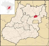
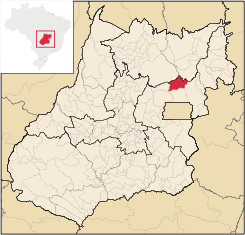
in northern Goiás
Goiás
Goiás is a state of Brazil, located in the central part of the country. The name Goiás comes from the name of an indigenous community...
state, Brazil
Brazil
Brazil , officially the Federative Republic of Brazil , is the largest country in South America. It is the world's fifth largest country, both by geographical area and by population with over 192 million people...
.
Location
Água Fria became a city in 1989 when it was dismembered from Planaltina de GoiásPlanaltina de Goiás
Planaltina is a city located in the center of the state of Goiás, Brazil. Planaltina is often referred to as Planaltina de Goiás, but in official documents it is called Planaltina.-Location and Geography:...
in 1989. Água Fria is located in the microregion called Entorno de Brasília, although it is almost 156 kilometers to the Plano Piloto of Brasília
Brasília
Brasília is the capital city of Brazil. The name is commonly spelled Brasilia in English. The city and its District are located in the Central-West region of the country, along a plateau known as Planalto Central. It has a population of about 2,557,000 as of the 2008 IBGE estimate, making it the...
. Communications are made by BR-020 to Planaltina
Planaltina
Planaltina is one of the administrative districts of the Federal District of Brazil, with an area of 1,534 kmª and a population of 147,114 in 2000, of whom 134,663 were classified as urban and 12,451 as rural...
, then north passing through Goiás. Another road links Água Fria by way of Mimoso de Goiás
Mimoso de Goiás
Mimoso de Goiás is a small town and municipality in northeastern Goiás state, Brazil.Mimoso is located in statistical microregion 012, called Entorno de Brasília. It is almost directly north of Brasília and is on an unpaved highway linking Padre Bernardo to Água Fria de Goiás...
and Padre Bernardo
Padre Bernardo
Padre Bernardo is a small city and municipality north of the Federal District of Brazil in Goiás state, Brazil.-Location:Padre Bernardo is located 42 km. north of the boundary with the Federal District...
.
The distance to the state capital, Goiânia
Goiânia
-Climate:The city has a tropical wet and dry climate with an average temperature of . There's a wet season, from October to April, and a dry one, from May to September. Annual rainfall is around 1,520 mm....
, is 342 km. Highway connections are made by BR-153 / Anápolis
Anápolis
Anápolis is the third largest city in the State of Goiás in Brazil. It lies in the center of a rich agricultural region and has become a leader in food processing and pharmaceutical plants.-Location and population:...
/ BR-060 / Alexânia
Alexânia
Alexânia is a small town and municipality in central Goiás state, Brazil. Alexânia is known for its alleged extraterrestrial sightings in the late sixties and early seventies. The Areias River passes through the municipality.-Location:...
/ Planaltina
Planaltina
Planaltina is one of the administrative districts of the Federal District of Brazil, with an area of 1,534 kmª and a population of 147,114 in 2000, of whom 134,663 were classified as urban and 12,451 as rural...
(DF) / GO-430 / BR-010/GO-118 / São Gabriel
São Gabriel
São Gabriel is a municipality in the state Rio Grande do Sul, Brazil.It's the birthplace of the Field Marshal Mascarenhas de Morais and Baron of Candiota.- Paleontology :This city belongs to the geopark of Paleorrota....
(district) / GO-230.
Municipal boundaries:
- north: NiquelândiaNiquelândiaNiquelândia is a small city and municipality in northern Goiás state, Brazil. It is the largest municipality in the state in area and is an important producer of minerals.-Geography:...
and Colinas do SulColinas do SulColinas do Sul is a small town and municipality in north-central Goiás state, Brazil.-Location:Colinas is located in the Chapada dos Veadeiros statistical micro-region and is almost directly north of Brasília, to which it is connected by G0-327 as far as Alto Paraíso de Goiás then by G0-118 south... - east: FormosaFormosa, GoiásFormosa is a city and municipality located in the state of Goiás, Brazil, approximately 80 kilometers east of Brasília. The population was 90,247 in a total area of 5,806.89 km² . Formosa is known for its waterfalls and natural beauty...
- west: Mimoso de GoiásMimoso de GoiásMimoso de Goiás is a small town and municipality in northeastern Goiás state, Brazil.Mimoso is located in statistical microregion 012, called Entorno de Brasília. It is almost directly north of Brasília and is on an unpaved highway linking Padre Bernardo to Água Fria de Goiás...
- south: Planaltina
Description
Água Fria is a quiet rural town far from the urban phenomena common to the cities located near BrasíliaBrasília
Brasília is the capital city of Brazil. The name is commonly spelled Brasilia in English. The city and its District are located in the Central-West region of the country, along a plateau known as Planalto Central. It has a population of about 2,557,000 as of the 2008 IBGE estimate, making it the...
. The urban area is made up of one main avenue, unpaved, and some cross streets. Along the avenue are the main public services which include the following: post office, telephone station, police station, town hall, health center, community center, tax office, a small library, and some small commercial shops and bars.
The residences, of adobe or brick, are on the side streets, which are also unpaved. Water is furnished to the population but is untreated. The sewage system consists of individual dwellings using septic tanks. There is only one health clinic (with a non-resident doctor) and one school.
Economy
The economy is based on cattle raising (44,900 head in 2006) and plantations of oranges (990 hectares), soybeans (19,000 hectares in 2006), corn (12,000 hectares in 2006), and beans. Orange production of 13,058 tons in 2006 made Água Fria the largest producer in the state. In 2006 there were 618 farms with a total area of 128,625 hectares, of which 26,500 hectares were cropland and 56,200 hectares were pasture. About 1,600 persons were directly connected to agriculture. Local commerce offers few employment possibilities and the biggest employer is the local government.Motor vehicles
- Number of automobiles: 210
- Number of pickup trucks: 27
- Number of inhabitants per motor vehicle: 21.13
Main crops in hectares
- Rice: 500
- Banana: 56
- Sugarcane: 24
- Beans: 7,600
- Oranges: 990
- Corn: 15,000
- Soybeans: 20,000
- Sorghum: 700 (All data are from 2006)
Health and education
Água Fria had a score of 0.69 on the 2000 Municipal Human Development IndexHuman Development Index
The Human Development Index is a composite statistic used to rank countries by level of "human development" and separate "very high human development", "high human development", "medium human development", and "low human development" countries...
, which gave it a state ranking of 212 (out of 242 municipalities)
and a national ranking of 3064 (out of 5507 municipalities).
- Hospitals: none (February 2007)
- Schools: 13 with 1,531 students (2006)
- Literacy rate in 2000: 80.3%
- Infant mortality rate in 2000: 25.57
'See also
- List of municipalities in Goiás
- Microregions of Goiás