
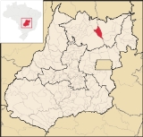
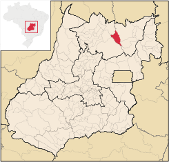
Colinas do Sul
Encyclopedia
| Colinas do Sul | |
|---|---|
| State | Goiás Goiás Goiás is a state of Brazil, located in the central part of the country. The name Goiás comes from the name of an indigenous community... |
| Coordinates: | 14°09′06"S 48°04′28"W |
| Area: | 1,708.2 km² |
| Population: | 3,856(IBGE 2007) |
| Population density | 2.26 inhab/km² |
| Urban population | 2,489 (2007) |
| Rural population | 1,367 (2007) |
| Elevation: | 5353m |
| Postcode (CEP): | 73740-000 |
| IBGE statistical microregion: | 018 Chapada dos Veadeiros Chapada dos Veadeiros Microregion The Chapada dos Veadeiros Microregion is an IBGE statistical region in north-central Goiás state, Brazil. It includes 8 cities with a population of 60,267 in a total area of 21,476 km²... |
| Became a city: | 1989 |
| Mayor: | Cristina Mary Fiuza Adorno |
| Distance to Goiânia Goiânia -Climate:The city has a tropical wet and dry climate with an average temperature of . There's a wet season, from October to April, and a dry one, from May to September. Annual rainfall is around 1,520 mm.... : |
458 km. |
| Website: | n/a |
Town
A town is a human settlement larger than a village but smaller than a city. The size a settlement must be in order to be called a "town" varies considerably in different parts of the world, so that, for example, many American "small towns" seem to British people to be no more than villages, while...
and municipality
Municipality
A municipality is essentially an urban administrative division having corporate status and usually powers of self-government. It can also be used to mean the governing body of a municipality. A municipality is a general-purpose administrative subdivision, as opposed to a special-purpose district...
in north-central Goiás
Goiás
Goiás is a state of Brazil, located in the central part of the country. The name Goiás comes from the name of an indigenous community...
state, Brazil
Brazil
Brazil , officially the Federative Republic of Brazil , is the largest country in South America. It is the world's fifth largest country, both by geographical area and by population with over 192 million people...
.
Location
Colinas is located in the Chapada dos VeadeirosChapada dos Veadeiros Microregion
The Chapada dos Veadeiros Microregion is an IBGE statistical region in north-central Goiás state, Brazil. It includes 8 cities with a population of 60,267 in a total area of 21,476 km²...
statistical micro-region and is almost directly north of Brasília
Brasília
Brasília is the capital city of Brazil. The name is commonly spelled Brasilia in English. The city and its District are located in the Central-West region of the country, along a plateau known as Planalto Central. It has a population of about 2,557,000 as of the 2008 IBGE estimate, making it the...
, to which it is connected by G0-327 as far as Alto Paraíso de Goiás
Alto Paraíso de Goiás
Alto Paraíso de Goiás is a small town and a municipality in northeastern Goiás state, Brazil. It has become known for its ecological and New Age tourism.-Location:...
then by G0-118 south to Planaltina
Planaltina
Planaltina is one of the administrative districts of the Federal District of Brazil, with an area of 1,534 kmª and a population of 147,114 in 2000, of whom 134,663 were classified as urban and 12,451 as rural...
, where the highway joins with BR-020. It is 458 kilometers from Goiânia
Goiânia
-Climate:The city has a tropical wet and dry climate with an average temperature of . There's a wet season, from October to April, and a dry one, from May to September. Annual rainfall is around 1,520 mm....
and 270 kilometers from Brasília
Brasília
Brasília is the capital city of Brazil. The name is commonly spelled Brasilia in English. The city and its District are located in the Central-West region of the country, along a plateau known as Planalto Central. It has a population of about 2,557,000 as of the 2008 IBGE estimate, making it the...
.
Highway connections from Goiânia
Goiânia
-Climate:The city has a tropical wet and dry climate with an average temperature of . There's a wet season, from October to April, and a dry one, from May to September. Annual rainfall is around 1,520 mm....
are made by GO-080 / Nerópolis
Nerópolis
Nerópolis is a small city and municipality in central Goiás state, Brazil.-Location:The municipality is part of the metropolitan region of Goiânia, which is 42 kilometers to the west. It is nationally known as the city of garlic and sweets...
/ Petrolina de Goiás
Petrolina de Goiás
Petrolina de Goiás is a small town and municipality in central Goiás state, Brazil.-Location:Petrolina de Goiás is located 81 km. almost due north of Goiânia, the state capital. It is 23 km. southwest of São Francisco de Goiás, 23 km. northwest of Ouro Verde de Goiás, 21 km....
/ BR-153 / Jaraguá / GO-080 / Goianésia
Goianésia
Goianésia is a municipality in the state of Goiás, Brazil. It is a large producer of sugarcane for production of alcohol used as a source of fuel.-Location:...
/ Barro Alto
Barro Alto
Barro Alto is a small town and municipality in northern Goiás state, Brazil, famous for its nickel mine and production of rubber. The population was 6,446 in 2007 and the total area of the municipality was 1,231.8 km².-Location:...
/ BR-080 / GO-342 / Uruaçu
Uruaçu
Uruaçu is a small city and municipality in north Goiás state, Brazil.-Geography:Uruaçu is located north of Anápolis and Goiânia on the important interstate highway BR-153, which links Brasília to Belém. It is 269 km. from Goiânia and 244 km. from Brasília...
/ GO-237 / Niquelândia
Niquelândia
Niquelândia is a small city and municipality in northern Goiás state, Brazil. It is the largest municipality in the state in area and is an important producer of minerals.-Geography:...
/ GO-132 / (54 km under construction in 2004).
Municipal boundaries are with:
- north: CavalcanteCavalcanteCavalcante is a small town and municipality in northern Goiás state, Brazil. It is one of the poorest municipalities in the state. It is home to communities of descendants of runaway slaves called Kalungas.-Location:...
- west: CampinaçuCampinaçuCampinaçu is a small town and municipality in north Goiás state, Brazil.-Location:Campinaçu is surrounded by the following municipalities:*north: Minaçu*east: Colinas do Sul*west: Campinorte and Uruaçu*south: Niquelândia...
and MinaçuMinaçuMinaçu is a small city and municipality in the north of the state of Goiás, Brazil. There is a large asbestos mine in the municipality.-Location and climate:... - east: Alto Paraíso de GoiásAlto Paraíso de GoiásAlto Paraíso de Goiás is a small town and a municipality in northeastern Goiás state, Brazil. It has become known for its ecological and New Age tourism.-Location:...
- south and west: NiquelândiaNiquelândiaNiquelândia is a small city and municipality in northern Goiás state, Brazil. It is the largest municipality in the state in area and is an important producer of minerals.-Geography:...
Colinas do Sul is halfway between São Jorge, district of Alto Paraíso de Goiás
Alto Paraíso de Goiás
Alto Paraíso de Goiás is a small town and a municipality in northeastern Goiás state, Brazil. It has become known for its ecological and New Age tourism.-Location:...
and Niquelândia
Niquelândia
Niquelândia is a small city and municipality in northern Goiás state, Brazil. It is the largest municipality in the state in area and is an important producer of minerals.-Geography:...
, near one of the southern arms of the Serra da Mesa artificial lake. By way of Colinas it is possible to reach touristic points on the banks of the lake, like Mato Verde (12 km.), Chapada da Visão, Chiqueiro de Pedra and Vale do Lago. On a dirt road it is possible to go around the Serra de Santana and the Chapada dos Veadeiros National Park
Chapada dos Veadeiros National Park
Brazil's Chapada dos Veadeiros National Park is located in the Chapada dos Veadeiros, an ancient plateau with an estimated age of 1.8 billion years. Based in the Brazilian state of Goias, the Park was created on January 11, 1961 by President Juscelino Kubitscheck, and listed as a World Heritage...
, going through Rio Preto and Capela until arriving at Cavalcante
Cavalcante
Cavalcante is a small town and municipality in northern Goiás state, Brazil. It is one of the poorest municipalities in the state. It is home to communities of descendants of runaway slaves called Kalungas.-Location:...
.
The economy
The main economic activities are ecotourism, based on the park, cattle raising (29,000 head in 2006) and some agriculture (rice and corn).Agricultural data 2006
- Farms: 363
- Total area: 130,630 ha.
- Area of permanent crops: 232 ha.
- Area of perennial crops: 1,405 ha.
- Area of natural pasture: 71,503 ha.
- Area of woodland and forests: 39,964 ha.
- Persons dependent on farming: 1,050
- Number of tractors: 86
- Cattle herd: 29,000
- Main crop: corn with 260 planted hectares IBGE
Health and education
- Schools: 08 (2006)
- Hospitals: 01 with 15 beds (2007)
- Adult literacy rate: 82.7% (2000)
- Infant mortality rate: 41.30 in 1,000 live births (2000)
- MHDI: 0.671
- State ranking: 228 (out of 242 municipalities)
- National ranking: 3,442 (out of 5,507 municipalities) Source: Frigoletto
History
Colinas do Sul appears for the first time in official documents as the district of Lages belonging to CavalcanteCavalcante
Cavalcante is a small town and municipality in northern Goiás state, Brazil. It is one of the poorest municipalities in the state. It is home to communities of descendants of runaway slaves called Kalungas.-Location:...
. In 1938 the district of Lages was made extinct and became the district of Cafelândia. In 1943 the district of Cafelândia changed its name to Araí. In 1949 the name of Lages returned. In 1955 the district of Lages passed to the district of Colinas, which in 1989 was dismembered from Cavalcante.