

Zone d'études et d'aménagement du territoire
Encyclopedia
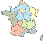
In 1967 the Institut national de la statistique et des études économiques (French National Institute for Statistics and Economic Studies, INSEE
INSEE
INSEE is the French National Institute for Statistics and Economic Studies. It collects and publishes information on the French economy and society, carrying out the periodic national census. Located in Paris, it is the French branch of Eurostat, European Statistical System...
), together with the French Commissariat général and DATAR (Délégation à l'aménagement du territoire et à l'action régionale) declared the nominal division of France
France
The French Republic , The French Republic , The French Republic , (commonly known as France , is a unitary semi-presidential republic in Western Europe with several overseas territories and islands located on other continents and in the Indian, Pacific, and Atlantic oceans. Metropolitan France...
into eight large regions. These were named Zones d'études et d'aménagement du territoire (Research and National Development Zones) or ZEAT.
Within the European Union
European Union
The European Union is an economic and political union of 27 independent member states which are located primarily in Europe. The EU traces its origins from the European Coal and Steel Community and the European Economic Community , formed by six countries in 1958...
the ZEAT corresponds to the first level
First level NUTS of the European Union
The Nomenclature of Territorial Units for Statistics, , is a geocode standard for referencing the administrative divisions of countries for statistical purposes. The standard was developed by the European Union.There are three levels of NUTS defined, with two levels of local administrative units ...
in the Nomenclature of Territorial Units for Statistics
Nomenclature of Territorial Units for Statistics
The Nomenclature of Territorial Units for Statistics or Nomenclature of Units for Territorial Statistics is a geocode standard for referencing the subdivisions of countries for statistical purposes...
(NUTS 1), putting them on a par with the States of Germany
States of Germany
Germany is made up of sixteen which are partly sovereign constituent states of the Federal Republic of Germany. Land literally translates as "country", and constitutionally speaking, they are constituent countries...
, as well as with Wales
Wales
Wales is a country that is part of the United Kingdom and the island of Great Britain, bordered by England to its east and the Atlantic Ocean and Irish Sea to its west. It has a population of three million, and a total area of 20,779 km²...
, Scotland
Scotland
Scotland is a country that is part of the United Kingdom. Occupying the northern third of the island of Great Britain, it shares a border with England to the south and is bounded by the North Sea to the east, the Atlantic Ocean to the north and west, and the North Channel and Irish Sea to the...
, Northern Ireland
Northern Ireland
Northern Ireland is one of the four countries of the United Kingdom. Situated in the north-east of the island of Ireland, it shares a border with the Republic of Ireland to the south and west...
and the regions of England
Regions of England
In England, the region is the highest tier of sub-national division used by central Government. Between 1994 and 2011, the nine regions had an administrative role in the implementation of UK Government policy, and as the areas covered by elected bodies...
.