
Zograf Peak
Encyclopedia
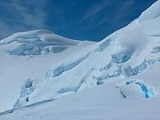
Zograf Peak rises to 1,011 metres at the northeastern extremity of the Friesland Ridge
in the Tangra Mountains
, Livingston Island in the South Shetland Islands
, Antarctica. The peak is heavily glaciated and crevassed, with precipitous and partly ice-free northern slopes. The peak surmounts Huron Glacier
to the north and Shipka Valley
to the east, and is accessible via the saddle of elevation 975 m linking it to the north rib of Lyaskovets Peak
. The peak is linked to the northeast by Lozen Saddle
to Lozen Nunatak
, Erma Knoll
and Aheloy Nunatak
.
The peak is named after the Bulgarian Zograf Monastery
on Mount Athos
.
First ascent by Lyubomir Ivanov from Camp Academia
on 31 December 2004.
, 4.26 km east by south of Pliska Peak
, 1.88 km south-southeast of Kuzman Knoll
, 3.9 km south by west of Maritsa Peak
and 1.55 km west of Komini Peak
.
, a central location in the upper Huron Glacier, Wörner Gap
area, eastern Livingston Island (62°38′41.9"S 60°10′18"W). This location can be accessed by an 11 km route from St. Kliment Ohridski base
, or a 12.5 km route from Juan Carlos I base
. The site offers convenient overland access to the Tangra Mountains
to the south; Bowles Ridge
, Vidin Heights
, Kaliakra Glacier
and Saedinenie Snowfield
areas to the north; Huron Glacier to the east and Perunika Glacier
and Huntress Glacier
to the west.
Camp Academia
hosted the base camp of the Bulgarian topographic survey Tangra 2004/05
from 3 December 2004 until 2 January 2005 and was named for the Bulgarian Academy of Sciences
in appreciation of that academy’s contribution to Antarctic exploration. Since 2004 the site has been designated as the summer post office Tangra 1091 of the Bulgarian Posts Plc.
Zograf Peak and Camp Academia
were mapped in 2005 and 2009 from the topographic survey Tangra 2004/05
.
Friesland Ridge
Friesland Ridge is a ridge on Livingston Island in the South Shetlands, part of the Tangra Mountains. The summit, Mount Friesland, which rises to , is the northwesternmost of the ridge’s six main peaks...
in the Tangra Mountains
Tangra Mountains
Tangra Mountains form the principal mountain range of Livingston Island in the South Shetland Islands, Antarctica...
, Livingston Island in the South Shetland Islands
South Shetland Islands
The South Shetland Islands are a group of Antarctic islands, lying about north of the Antarctic Peninsula, with a total area of . By the Antarctic Treaty of 1959, the Islands' sovereignty is neither recognized nor disputed by the signatories and they are free for use by any signatory for...
, Antarctica. The peak is heavily glaciated and crevassed, with precipitous and partly ice-free northern slopes. The peak surmounts Huron Glacier
Huron Glacier
Huron Glacier is a 7.7 km long and 3.5 km wide glacial flow on Livingston Island in the South Shetland Islands, Antarctica. The glacier is bounded by Bowles Ridge to the north, Wörner Gap to the west and Tangra Mountains to the south, receiving ice influx from several tributary glaciers...
to the north and Shipka Valley
Shipka Valley
Shipka Valley valley extending 2.4 km and 700 m wide in Tangra Mountains, Livingston Island in the South Shetland Islands, Antarctica...
to the east, and is accessible via the saddle of elevation 975 m linking it to the north rib of Lyaskovets Peak
Lyaskovets Peak
Lyaskovets Peak is the easternmost peak of Friesland Ridge in the Tangra Mountains, eastern Livingston Island and has an elevation 1,473 m...
. The peak is linked to the northeast by Lozen Saddle
Lozen Saddle
Lozen Saddle is a 437 m high saddle situated between Lozen Nunatak and Zograf Peak in Tangra Mountains, eastern Livingston Island in the South Shetland Islands, Antarctica which provides overland access from the Wörner Gap area to the Shipka Valley...
to Lozen Nunatak
Lozen Nunatak
Lozen Nunatak is a 440m hill in upper Huron Glacier, Livingston Island. It is part of a minor ridge in the north foothills of Tangra Mountains including also Erma Knoll and Aheloy Nunatak, and linked to Zograf Peak by Lozen Saddle. The hill was first visited on 17 December 2004 by the Bulgarian...
, Erma Knoll
Erma Knoll
Erma Knoll is a 412m peak in upper Huron Glacier, Livingston Island. The peak was first visited on 17 December 2004 by the Bulgarian Lyubomir Ivanov from Camp Academia, and was mapped by Bulgaria in 2005 and 2009 from the Tangra 2004/05 topographic survey. The knoll is named after Erma River in...
and Aheloy Nunatak
Aheloy Nunatak
Aheloy Nunatak is a rocky 390m peak in the upper Huron Glacier in Livingston Island. The peak forms the northeast extremity of a minor ridge which also features Erma Knoll and Lozen Nunatak, and is linked to Zograf Peak by Lozen Saddle...
.
The peak is named after the Bulgarian Zograf Monastery
Zograf Monastery
The Saint George the Zograf Monastery or Zograf Monastery is a Bulgarian Orthodox monastery on Mount Athos in Greece...
on Mount Athos
Mount Athos
Mount Athos is a mountain and peninsula in Macedonia, Greece. A World Heritage Site, it is home to 20 Eastern Orthodox monasteries and forms a self-governed monastic state within the sovereignty of the Hellenic Republic. Spiritually, Mount Athos comes under the direct jurisdiction of the...
.
First ascent by Lyubomir Ivanov from Camp Academia
Camp Academia
Camp Academia is a geographical locality in eastern Livingston Island, South Shetland Islands, Antarctica, named for the Bulgarian Academy of Sciences in appreciation of Academy’s contribution to the Antarctic exploration...
on 31 December 2004.
Location
The peak is located 1.33 km north by west of Lyaskovets PeakLyaskovets Peak
Lyaskovets Peak is the easternmost peak of Friesland Ridge in the Tangra Mountains, eastern Livingston Island and has an elevation 1,473 m...
, 4.26 km east by south of Pliska Peak
Pliska Ridge
Pliska Ridge is a three-peaked ridge rising to 667 m in eastern Livingston Island in the South Shetland Islands, Antarctica...
, 1.88 km south-southeast of Kuzman Knoll
Kuzman Knoll
Kuzman Knoll is a solitary ice-covered knoll rising to 620 m in eastern Livingston Island in the South Shetland Islands, Antarctica. The knoll forms a conspicuous landmark in Wörner Gap area, overlooking Huron Glacier and upper Perunika Glacier...
, 3.9 km south by west of Maritsa Peak
Maritsa Peak
Maritsa Peak rises to 560 m in eastern Bowles Ridge on Livingston Island in the South Shetland Islands, Antarctica. It has precipitous rocky south slopes, and is situated on the west side of Pirdop Gate, surmounting Huron Glacier to the south and Struma Glacier to the north...
and 1.55 km west of Komini Peak
Komini Peak
Komini Peak is a peak with an elevation of on the north slopes of Levski Peak, in the Tangra Mountains, in Livingston Island, Antarctica.The peak has precipitous rocky western slopes and was first climbed by Lyubomir Ivanov from Camp Academia by way of its 212-m high western rock wall on 21...
.
Camp Academia
The northwestern foothills of Zograf Peak are known as Camp AcademiaCamp Academia
Camp Academia is a geographical locality in eastern Livingston Island, South Shetland Islands, Antarctica, named for the Bulgarian Academy of Sciences in appreciation of Academy’s contribution to the Antarctic exploration...
, a central location in the upper Huron Glacier, Wörner Gap
Wörner Gap
Wörner Gap is a flat saddle extending 3 km in the south-north direction between Friesland Ridge and Bowles Ridge in eastern Livingston Island in the South Shetland Islands, Antarctica. Its elevation decreases from 585 m in the south to 541 m in the middle, and 525 m in the north...
area, eastern Livingston Island (62°38′41.9"S 60°10′18"W). This location can be accessed by an 11 km route from St. Kliment Ohridski base
St. Kliment Ohridski Base
St. Kliment Ohridski Base is a Bulgarian Antarctic base on Livingston Island in the South Shetland Islands.The base, originally known as Sofia University Refuge, was named in 1993 "for St...
, or a 12.5 km route from Juan Carlos I base
Juan Carlos I Base
Juan Carlos I Antarctic Base, named after the king of Spain, Juan Carlos I, is a seasonal scientific station operated by Spain, opened in January 1988...
. The site offers convenient overland access to the Tangra Mountains
Tangra Mountains
Tangra Mountains form the principal mountain range of Livingston Island in the South Shetland Islands, Antarctica...
to the south; Bowles Ridge
Bowles Ridge
Bowles Ridge is the central ridge of eastern Livingston Island. The ridge extends 6.5 km in the east-west direction and is 1.5 km wide. The summit of the ridge is Mount Bowles which rises to 822m and is located 9.77 km northwest of Great Needle Peak, 6.08 km north by west of...
, Vidin Heights
Vidin Heights
Vidin Heights are predominantly ice-covered heights rising to 604 m on Varna Peninsula, eastern Livingston Island in the South Shetland Islands, Antarctica. The feature is approximately 8 km long from the north end of Leslie Gap east-northeastwards to Inott Point and 9.6 km...
, Kaliakra Glacier
Kaliakra Glacier
Kaliakra Glacier is a glacier in northeastern Livingston Island, Antarctica extending 7 km in east-west direction and 8 km in north-south direction...
and Saedinenie Snowfield
Saedinenie Snowfield
Saedinenie Snowfield on Livingston Island in the South Shetland Islands, Antarctica, is bounded by Teres Ridge to the west, the glacial divide between the Drake Passage and Bransfield Strait to the south, Gleaner Heights, Elhovo Gap and Leslie Hill to the southeast, and Leslie Gap and Vidin...
areas to the north; Huron Glacier to the east and Perunika Glacier
Perunika Glacier
Perunika Glacier is an 8 km long and 3 km wide roughly crescent-shaped glacier in eastern Livingston Island in the South Shetland Islands, Antarctica....
and Huntress Glacier
Huntress Glacier
Huntress Glacier is a 7 km long and 3.7 km wide glacier on Livingston Island in the South Shetland Islands, Antarctica bounded by Friesland Ridge, Tangra Mountains to the southeast, Nesebar Gap, Pliska Ridge, Burdick Ridge and Willan Nunatak to the north, and Charrúa Gap and Napier Peak...
to the west.
Camp Academia
Camp Academia
Camp Academia is a geographical locality in eastern Livingston Island, South Shetland Islands, Antarctica, named for the Bulgarian Academy of Sciences in appreciation of Academy’s contribution to the Antarctic exploration...
hosted the base camp of the Bulgarian topographic survey Tangra 2004/05
Tangra 2004/05
The Tangra 2004/05 Expedition was commissioned by the Antarctic Place-names Commission at the Ministry of Foreign Affairs of Bulgaria, managed by the Manfred Wörner Foundation, and supported by the Bulgarian Antarctic Institute, the Institute of Mathematics and Informatics at the Bulgarian Academy...
from 3 December 2004 until 2 January 2005 and was named for the Bulgarian Academy of Sciences
Bulgarian Academy of Sciences
The Bulgarian Academy of Sciences is the National Academy of Bulgaria, established in 1869. The Academy is autonomous and has a Society of Academicians, Correspondent Members and Foreign Members...
in appreciation of that academy’s contribution to Antarctic exploration. Since 2004 the site has been designated as the summer post office Tangra 1091 of the Bulgarian Posts Plc.
Zograf Peak and Camp Academia
Camp Academia
Camp Academia is a geographical locality in eastern Livingston Island, South Shetland Islands, Antarctica, named for the Bulgarian Academy of Sciences in appreciation of Academy’s contribution to the Antarctic exploration...
were mapped in 2005 and 2009 from the topographic survey Tangra 2004/05
Tangra 2004/05
The Tangra 2004/05 Expedition was commissioned by the Antarctic Place-names Commission at the Ministry of Foreign Affairs of Bulgaria, managed by the Manfred Wörner Foundation, and supported by the Bulgarian Antarctic Institute, the Institute of Mathematics and Informatics at the Bulgarian Academy...
.
Maps
- L.L. Ivanov et al. Antarctica: Livingston Island and Greenwich Island, South Shetland Islands. Scale 1:100000 topographic map. Sofia: Antarctic Place-names Commission of Bulgaria, 2005.
- L.L. Ivanov. Antarctica: Livingston Island and Greenwich, Robert, Snow and Smith Islands. Scale 1:120000 topographic map. Troyan: Manfred Wörner Foundation, 2009. ISBN 978-954-92032-6-4