

Saedinenie Snowfield
Encyclopedia
South Shetland Islands
The South Shetland Islands are a group of Antarctic islands, lying about north of the Antarctic Peninsula, with a total area of . By the Antarctic Treaty of 1959, the Islands' sovereignty is neither recognized nor disputed by the signatories and they are free for use by any signatory for...
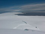
, Antarctica, is bounded by Teres Ridge
Teres Ridge
Teres Ridge is a ridge of elevation 330 m extending 2 km in north-south direction and 1.2 km in east-west direction near Siddons Point on the Hero Bay coast of Livingston Island in the South Shetland Islands, Antarctica surmounting Tundzha Glacier to the southwest and Saedinenie...
to the west, the glacial divide between the Drake Passage
Drake Passage
The Drake Passage or Mar de Hoces—Sea of Hoces—is the body of water between the southern tip of South America at Cape Horn, Chile and the South Shetland Islands of Antarctica...
and Bransfield Strait
Bransfield Strait
Bransfield Strait is a body of water about wide extending for in a general northeast-southwest direction between the South Shetland Islands and Antarctic Peninsula. It was named in about 1825 by James Weddell, Master, Royal Navy, for Edward Bransfield, Master, RN, who charted the South Shetland...
to the south, Gleaner Heights
Gleaner Heights
Gleaner Heights is a series of elevations extending southwest from Leslie Hill in the eastern part of Livingston Island in the South Shetland Islands, Antarctica...
, Elhovo Gap
Elhovo Gap
Elhovo Gap is a 420 m high saddle extending 1 km in westsouthwest-eastnortheast direction from Gleaner Heights to Leslie Hill, Livingston Island in the South Shetland Islands, Antarctica which forms part of the overland route between Bowles Ridge and Vidin Heights...
and Leslie Hill
Leslie Hill, Livingston Island
Leslie Hill is a hill lying northward of Bowles Ridge and south of Vidin Heights in the eastern part of Livingston Island in the South Shetland Islands, Antarctica...
to the southeast, and Leslie Gap
Leslie Gap
Leslie Gap is an 359m high ice-covered saddle extending 2.8 km in south-north direction between Leslie Hill and Radnevo Peak on Varna Peninsula in northeastern Livingston Island in the South Shetland Islands, Antarctica. The saddle separates the glacial catchments of Kaliakra Glacier to the...
and Vidin Heights
Vidin Heights
Vidin Heights are predominantly ice-covered heights rising to 604 m on Varna Peninsula, eastern Livingston Island in the South Shetland Islands, Antarctica. The feature is approximately 8 km long from the north end of Leslie Gap east-northeastwards to Inott Point and 9.6 km...
to the east. It extends 4.7 km inland, and 15.5 km in southwest-northeast direction and drains into Hero Bay
Hero Bay
Hero Bay is a 17 mi wide bay, which indents for 6 mi the north side of Livingston Island between Cape Shirreff and Williams Point, in the South Shetland Islands. The name ‘Blythe Bay’, originally applied to a small bay on the southeast side of Desolation Island on Powell's chart of 1822...
between Melta Point
Melta Point
Melta Point is a rocky point on the coast of Hero Bay, Livingston Island, formed by an offshoot of Teres Ridge. Adjacent ice-free area . The point is named after the ancient Melta, ancestor of the present town of Lovech in Northern Bulgaria...
and Slab Point
Slab Point
Slab Point is a rocky point on the northwest coast of Varna Peninsula, Livingston Island in the South Shetland Islands, Antarctica forming the north side of the entrance to Eliseyna Cove and the south side of the entrance to Charybdis Cove....
.
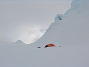
A survey bivouac in eastern Saedinenie Snowfield near Leslie Hill
Leslie Hill, Livingston Island
Leslie Hill is a hill lying northward of Bowles Ridge and south of Vidin Heights in the eastern part of Livingston Island in the South Shetland Islands, Antarctica...
was occupied 24–28 December 2004.
The snowfield was named after the Bulgaria
Bulgaria
Bulgaria , officially the Republic of Bulgaria , is a parliamentary democracy within a unitary constitutional republic in Southeast Europe. The country borders Romania to the north, Serbia and Macedonia to the west, Greece and Turkey to the south, as well as the Black Sea to the east...
n town of Saedinenie
Saedinenie
Saedinenie is a town in the Plovdiv Province, central Bulgaria. As of 2006 it has 6 302 inhabitants. There is a new electronics plant there with 540 employees.-Honour:...
(‘Reunification’), in association with the 120th anniversary of the Reunification of the Principality of Bulgaria
Principality of Bulgaria
The Principality of Bulgaria was a self-governing entity created as a vassal of the Ottoman Empire by the Treaty of Berlin in 1878. The preliminary treaty of San Stefano between the Russian Empire and the Porte , on March 3, had originally proposed a significantly larger Bulgarian territory: its...
and the province of Eastern Rumelia
Eastern Rumelia
Eastern Rumelia or Eastern Roumelia was an administratively autonomous province in the Ottoman Empire and Principality of Bulgaria from 1878 to 1908. It was under full Bulgarian control from 1885 on, when it willingly united with the tributary Principality of Bulgaria after a bloodless revolution...
in 1885. This is one of the Bulgarian names bestowed on hitherto nameless geographical features by by the Tangra 2004/05
Tangra 2004/05
The Tangra 2004/05 Expedition was commissioned by the Antarctic Place-names Commission at the Ministry of Foreign Affairs of Bulgaria, managed by the Manfred Wörner Foundation, and supported by the Bulgarian Antarctic Institute, the Institute of Mathematics and Informatics at the Bulgarian Academy...
Expedition.
Location
The snowfield is centred at 62°32′36"S 60°13′38"W (Bulgarian topographic survey Tangra 2004/05Tangra 2004/05
The Tangra 2004/05 Expedition was commissioned by the Antarctic Place-names Commission at the Ministry of Foreign Affairs of Bulgaria, managed by the Manfred Wörner Foundation, and supported by the Bulgarian Antarctic Institute, the Institute of Mathematics and Informatics at the Bulgarian Academy...
and mapping in 2005 and 2009).
Maps
- L.L. Ivanov et al. Antarctica: Livingston Island and Greenwich Island, South Shetland Islands. Scale 1:100000 topographic map. Sofia: Antarctic Place-names Commission of Bulgaria, 2005.
- L.L. Ivanov. Antarctica: Livingston Island and Greenwich, Robert, Snow and Smith Islands. Scale 1:120000 topographic map. Troyan: Manfred Wörner Foundation, 2009. ISBN 978-954-92032-6-4