

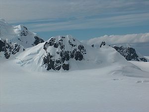
Maritsa Peak
Encyclopedia
Bowles Ridge
Bowles Ridge is the central ridge of eastern Livingston Island. The ridge extends 6.5 km in the east-west direction and is 1.5 km wide. The summit of the ridge is Mount Bowles which rises to 822m and is located 9.77 km northwest of Great Needle Peak, 6.08 km north by west of...
on Livingston Island in the South Shetland Islands
South Shetland Islands
The South Shetland Islands are a group of Antarctic islands, lying about north of the Antarctic Peninsula, with a total area of . By the Antarctic Treaty of 1959, the Islands' sovereignty is neither recognized nor disputed by the signatories and they are free for use by any signatory for...
, Antarctica. It has precipitous rocky south slopes, and is situated on the west side of Pirdop Gate
Pirdop Gate
Pirdop Gate is a 300-m wide pass between Maritsa Peak and Atanasoff Nunatak in eastern Bowles Ridge, Livingston Island in the South Shetland Islands, Antarctica. It has an elevation of 376 m at its northern entrance from Struma Glacier, and 261 m at the southern entrance from Huron Glacier...
, surmounting Huron Glacier
Huron Glacier
Huron Glacier is a 7.7 km long and 3.5 km wide glacial flow on Livingston Island in the South Shetland Islands, Antarctica. The glacier is bounded by Bowles Ridge to the north, Wörner Gap to the west and Tangra Mountains to the south, receiving ice influx from several tributary glaciers...
to the south and Struma Glacier
Struma Glacier
Struma Glacier is a glacier in eastern Livingston Island in the South Shetland Islands, Antarctica draining the area between Bowles Ridge and Melnik Ridge. The glacier is 4.8 km long and 1.5 km wide, flowing eastwards into Moon Bay south of Sindel Point and north of Elemag Point...
to the north. The peak is named after the Maritsa River
Maritsa
The Maritsa or Evros , ) is, with a length of 480 km, the longest river that runs solely in the interior of the Balkans. It has its origin in the Rila Mountains in Western Bulgaria, flowing southeast between the Balkan and Rhodope Mountains, past Plovdiv and Parvomay to Edirne, Turkey...
in Bulgaria.
Location
The cliff is located at 62°37′04"S 60°08′17"W which is 3.3 km east of Mount BowlesMount Bowles
Mount Bowles is an ice-covered mountain of elevation 822 m, the summit of Bowles Ridge in eastern Livingston Island, South Shetland Islands. Situated 3 mi north of Mount Friesland to which it is linked by Wörner Gap. Coordinates and elevation given according to 2003 Australian GPS survey...
, 970 m southeast of Asparuh Peak
Asparuh Peak
Asparuh Peak is a peak situated on Livingston Island, Antarctica. The peak rises to 760m in Bowles Ridge and is linked to the Melnik Ridge by the 575m high Yankov Gap...
, 1.18 km west-southwest of Atanasoff Nunatak
Atanasoff Nunatak
Atanasoff Nunatak is a nunatak, a sharp peak rising to 523 m in the east extremity of Bowles Ridge, Livingston Island, Antarctica. The peak sumounts Huron Glacier to the south and east, and Struma Glacier to the north...
, 2.48 km north of Aheloy Nunatak
Aheloy Nunatak
Aheloy Nunatak is a rocky 390m peak in the upper Huron Glacier in Livingston Island. The peak forms the northeast extremity of a minor ridge which also features Erma Knoll and Lozen Nunatak, and is linked to Zograf Peak by Lozen Saddle...
and 2.37 km northeast of Kuzman Knoll
Kuzman Knoll
Kuzman Knoll is a solitary ice-covered knoll rising to 620 m in eastern Livingston Island in the South Shetland Islands, Antarctica. The knoll forms a conspicuous landmark in Wörner Gap area, overlooking Huron Glacier and upper Perunika Glacier...
. Bulgarian topographic survey Tangra 2004/05
Tangra 2004/05
The Tangra 2004/05 Expedition was commissioned by the Antarctic Place-names Commission at the Ministry of Foreign Affairs of Bulgaria, managed by the Manfred Wörner Foundation, and supported by the Bulgarian Antarctic Institute, the Institute of Mathematics and Informatics at the Bulgarian Academy...
and mapping in 2005 and 2009.
Maps
- L.L. Ivanov et al. Antarctica: Livingston Island and Greenwich Island, South Shetland Islands. Scale 1:100000 topographic map. Sofia: Antarctic Place-names Commission of Bulgaria, 2005.
- L.L. Ivanov. Antarctica: Livingston Island and Greenwich, Robert, Snow and Smith Islands. Scale 1:120000 topographic map. Troyan: Manfred Wörner Foundation, 2009.