

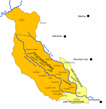
Ystradyfodwg
Encyclopedia
Highland (geography)
The term highland or upland is used to denote any mountainous region or elevated mountainous plateau. Generally speaking, the term upland tends to be used for ranges of hills, typically up to 500-600m, and highland for ranges of low mountains.The Scottish Highlands refers to the mountainous...
parish
Parish
A parish is a territorial unit historically under the pastoral care and clerical jurisdiction of one parish priest, who might be assisted in his pastoral duties by a curate or curates - also priests but not the parish priest - from a more or less central parish church with its associated organization...
in Glamorganshire, Wales
Wales
Wales is a country that is part of the United Kingdom and the island of Great Britain, bordered by England to its east and the Atlantic Ocean and Irish Sea to its west. It has a population of three million, and a total area of 20,779 km²...
. It is believed to have been named after Tyfodwg (or Dyfodwg) who was either a 7th century saint or chieftain.
It included most of the valleys of the Rhondda
Rhondda
Rhondda , or the Rhondda Valley , is a former coal mining valley in Wales, formerly a local government district, consisting of 16 communities built around the River Rhondda. The valley is made up of two valleys, the larger Rhondda Fawr valley and the smaller Rhondda Fach valley...
Fawr and Rhondda Fach rivers. Initially a sparsely populated wild area of upland sheep-walks, it became in the mid 19th century a dynamic centre of the coal mining
Coal mining
The goal of coal mining is to obtain coal from the ground. Coal is valued for its energy content, and since the 1880s has been widely used to generate electricity. Steel and cement industries use coal as a fuel for extraction of iron from iron ore and for cement production. In the United States,...
industry, with a large, new industrial population.
The parish was large, with an area of 10127 Hectare
Hectare
The hectare is a metric unit of area defined as 10,000 square metres , and primarily used in the measurement of land. In 1795, when the metric system was introduced, the are was defined as being 100 square metres and the hectare was thus 100 ares or 1/100 km2...
s, but had only 542 inhabitants in 1801. It stretched from the confluence
Confluence
Confluence, in geography, describes the meeting of two or more bodies of water.Confluence may also refer to:* Confluence , a property of term rewriting systems...
of the Rhondda rivers at Porth
Porth
Porth is a town and a community in the county borough of Rhondda Cynon Taf, within the historic county boundaries of Glamorgan, Wales, lying in the Rhondda Valley and is regarded as the gateway to the Rhondda Fawr and Rhondda Fach valleys because both valleys meet at Porth...
, over the mountain as far as the Vale of Neath
River Neath
River Neath is a river in south Wales running south west from its source in the Brecon Beacons National Park to its mouth at Baglan Bay below Briton Ferry on the east side of Swansea Bay.Several minor rivers rise on the southern slopes of Fforest Fawr...
. It was divided into four townships or hamlet (place)
Hamlet (place)
A hamlet is usually a rural settlement which is too small to be considered a village, though sometimes the word is used for a different sort of community. Historically, when a hamlet became large enough to justify building a church, it was then classified as a village...
s: Home (between the rivers), Clydach (south of the Rhondda Fawr), Middle (the upper part of the valley) and Rhigos
Rhigos
Rhigos is a village in the north of the Cynon Valley, in the county borough of Rhondda Cynon Taf, Wales. For postal purposes it comes under the town of Aberdare, although it is some from Aberdare town centre....
(north of the mountains).
During the 19th century, the population of the parish increased as follows:
| 1811 | 1821 | 1831 | 1841 | 1851 | 1861 | 1871 | 1881 | 1891 | 1901 | |
|---|---|---|---|---|---|---|---|---|---|---|
| Population | 973 | 985 | 1047 | 1363 | 1998 | 3857 | 17777 | 45052 | 69685 | 89907 |
Lower-quality coal from the Upper Coal series was worked in a small way in Trealaw
Trealaw
Trealaw is the longest village in the Rhondda Valley, Rhondda Cynon Taf, Wales.Trealaw stretches over two miles from the junction of Cemetery Road and Brithweunydd Road in the east, to the junction of Ynyscynon Road and Partridge Road to the northwest....
as early as 1807, but the development of the Rhondda steam coal
Coal
Coal is a combustible black or brownish-black sedimentary rock usually occurring in rock strata in layers or veins called coal beds or coal seams. The harder forms, such as anthracite coal, can be regarded as metamorphic rock because of later exposure to elevated temperature and pressure...
gave rise to the rapid population growth. The development began with the start-up of the Bute Merthyr colliery in Treherbert
Treherbert
Treherbert is a village and community situated at the head of the Rhondda Fawr valley in the county borough of Rhondda Cynon Taf, Wales. Treherbert is a former industrial coal mining village which was at its economic peak between 1850 and 1920...
in 1855. In the Rhondda Fach, the first coal was mined in 1862 at Ferndale. The Taff Vale Railway
Taff Vale Railway
The Taff Vale Railway is a railway in Glamorgan, South Wales, and is one of the oldest in Wales. It operated as an independent company from 1836 until 1922, when it became a constituent company of the Great Western Railway...
reached Treherbert
Treherbert
Treherbert is a village and community situated at the head of the Rhondda Fawr valley in the county borough of Rhondda Cynon Taf, Wales. Treherbert is a former industrial coal mining village which was at its economic peak between 1850 and 1920...
in 1856. Collieries then rapidly developed along the valley, with the lower part of the valley developing last because of the deeper pits required to find the steam coal in that area. By the end of the century, mining villages formed an almost continuous urban strip along both valley floors, with coal mining and its ancillary trades virtually the sole industry.
The majority of the incomers came from West Wales
West Wales
West Wales is the western area of Wales.Some definitions of West Wales include only Pembrokeshire, Ceredigion and Carmarthenshire, an area which historically comprised the Welsh principality of Deheubarth., an area called "South West Wales" in the Nomenclature of Territorial Units for Statistics....
, particularly Carmarthenshire
Carmarthenshire
Carmarthenshire is a unitary authority in the south west of Wales and one of thirteen historic counties. It is the 3rd largest in Wales. Its three largest towns are Llanelli, Carmarthen and Ammanford...
and Ceredigion
Ceredigion
Ceredigion is a county and former kingdom in mid-west Wales. As Cardiganshire , it was created in 1282, and was reconstituted as a county under that name in 1996, reverting to Ceredigion a day later...
and spoke Welsh
Welsh language
Welsh is a member of the Brythonic branch of the Celtic languages spoken natively in Wales, by some along the Welsh border in England, and in Y Wladfa...
. Over 70% of the population of the parish
Parish
A parish is a territorial unit historically under the pastoral care and clerical jurisdiction of one parish priest, who might be assisted in his pastoral duties by a curate or curates - also priests but not the parish priest - from a more or less central parish church with its associated organization...
was Welsh-speaking in 1891.
In 1877, the Hamlet of Rhigos was made a separate civil parish, and the remainder of Ystradyfodwg, together with the adjoining Rhondda valley portions of the parishes of Llanwonno and Llantrisant
Llantrisant
Llantrisant is a town in the county borough of Rhondda Cynon Taf in Wales, within the historic county boundaries of Glamorgan, Wales, lying on the River Ely and the Afon Clun. The town's name translates as The Parish of the Three Saints. The three saints in question are St Illtyd, St Gwynno and St...
, became the urban sanitary district of Ystradyfodwg. This extended district became Ystradyfodwg Civil Parish and Urban District in 1894, and was re-named Rhondda Civil Parish and Urban District in 1897. See Rhondda (district)
Rhondda (district)
Rhondda was a local government district based around the geographical area of the Rhondda Valley, south Wales.The district was initially created as Ystradyfodwg Local Government District from parts of Ystradyfodwg, Llanwonno and Llantrisant parishes, Glamorgan, in 1877, when the Local Government...
.