

Yoshiwara-juku
Encyclopedia
53 Stations of the Tokaido
The are the rest areas along the Tōkaidō, which was a coastal route that ran from Nihonbashi in Edo to Sanjō Ōhashi in Kyoto.-Stations of the Tōkaidō:...
of the Tōkaidō
Tokaido (road)
The ' was the most important of the Five Routes of the Edo period, connecting Edo to Kyoto in Japan. Unlike the inland and less heavily travelled Nakasendō, the Tōkaidō travelled along the sea coast of eastern Honshū, hence the route's name....
. It is located in the present-day city of Fuji
Fuji, Shizuoka
is a city in eastern Shizuoka Prefecture. Fuji is the 3rd largest city in terms of population in Shizuoka Prefecture, trailing Hamamatsu and Shizuoka. As of February 2010, the city has an estimated population of 254,113 and a population density of 1040 persons per km²...
, Shizuoka Prefecture
Shizuoka Prefecture
is a prefecture of Japan located in the Chūbu region on Honshu island. The capital is the city of Shizuoka.- History :Shizuoka prefecture was formed from the former Tōtōmi, Suruga and Izu provinces.The area was the home of the first Tokugawa Shogun...
, Japan
Japan
Japan is an island nation in East Asia. Located in the Pacific Ocean, it lies to the east of the Sea of Japan, China, North Korea, South Korea and Russia, stretching from the Sea of Okhotsk in the north to the East China Sea and Taiwan in the south...
.
The Yoshiwara-juku Festival is held each year in October and November in Fuji, showing visitors the area's history.
History
The Yoshiwara-juku was originally located near the present-day Yoshiwara StationYoshiwara Station
is an interchange railway station in Fuji, Shizuoka Prefecture, Japan. The station is 141.3 rail kilometers from Tokyo Station. Yoshiwara is on the Tōkaidō Main Line of Central Japan Railway Company and is a terminal station for the Gakunan Railway Line of the Gakunan Railway and a freight...
, on the modern Tōkaidō Main Line
Tokaido Main Line
The is the busiest trunk line of the Japan Railways Group , connecting Tōkyō and Kōbe stations. It is long, not counting its many freight feeder lines around the major cities...
railway, but after a very destructive tsunami
Tsunami
A tsunami is a series of water waves caused by the displacement of a large volume of a body of water, typically an ocean or a large lake...
in 1639, was rebuilt further inland, on what is now the Yodahara section of present-day Fuji. In 1680, the area was again devastated by a large tsunami, and the post town
Shukuba
were post stations during the Edo period in Japan, generally located on one of the Edo Five Routes or one of its sub-routes. They were also called shukueki . These post stations were places where travelers could rest on their journey around the nation...
was again relocated and moved to its current place. Although most of the route of the Tōkaidō in Sagami
Sagami Province
was an old province in the area that is today the central and western Kanagawa prefecture. It was sometimes called . Sagami bordered on Izu, Musashi, Suruga provinces; and had access to the Pacific Ocean through Sagami Bay...
and Suruga Province
Suruga Province
was an old province in the area that is today the central part of Shizuoka prefecture. It was sometimes called . Suruga bordered on Izu, Kai, Sagami, Shinano, and Tōtōmi provinces; and had access to the Pacific Ocean through Suruga Bay.-History:...
s was along the seashore as the name "East Sea Route"
implied, at Hara-juku
Hara-juku (Tokaido)
was the thirteenth of the fifty-three stations of the Tōkaidō. It is located in the present-day city of Numazu, Shizuoka Prefecture, Japan.-History:...
travelers walked away from the sea. Also, up until this point on the journey, Mount Fuji
Mount Fuji
is the highest mountain in Japan at . An active stratovolcano that last erupted in 1707–08, Mount Fuji lies about south-west of Tokyo, and can be seen from there on a clear day. Mount Fuji's exceptionally symmetrical cone is a well-known symbol of Japan and it is frequently depicted in art and...
could always be seen to the right of the travelers coming from Edo
Edo
, also romanized as Yedo or Yeddo, is the former name of the Japanese capital Tokyo, and was the seat of power for the Tokugawa shogunate which ruled Japan from 1603 to 1868...
. However, as they traveled inland, they could see Mount Fuji to their left, and the view came to be called .
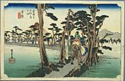
During the Edo period
Edo period
The , or , is a division of Japanese history which was ruled by the shoguns of the Tokugawa family, running from 1603 to 1868. The political entity of this period was the Tokugawa shogunate....
, there was a long colonnade of pine trees lining the route along this point. This is depicted in the classic ukiyoe print by Ando Hiroshige (Hoeido edition) from 1831-1834 which shows a groom leading a horse with women travelers down a narrow path lined with pine trees with Mount Fuji to the left.
Neighboring post towns
Tōkaidō- Hara-jukuHara-juku (Tokaido)was the thirteenth of the fifty-three stations of the Tōkaidō. It is located in the present-day city of Numazu, Shizuoka Prefecture, Japan.-History:...
- Yoshiwara-juku - Kanbara-jukuKanbara-jukuwas the fifteenth of the fifty-three stations of the Tōkaidō. It is located in what is now part of the Shimizu-ku ward of Shizuoka, Shizuoka Prefecture, Japan...
Further reading
- Carey, Patrick. Rediscovering the Old Tokaido:In the Footsteps of Hiroshige. Global Books UK (2000). ISBN 1901903109
- Chiba, Reiko. Hiroshige's Tokaido in Prints and Poetry. Tuttle. (1982) ISBN 0804802467
- Taganau, Jilly. The Tokaido Road: Travelling and Representation in Edo and Meiji Japan. RoutledgeCurzon (2004). ISBN 0415310911