

Lambityeco
Encyclopedia
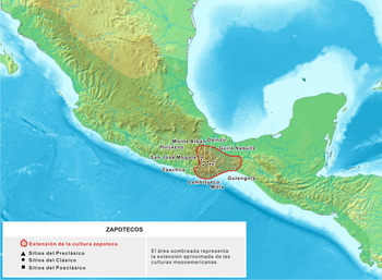
| Zapotec Culture – Archaeological Site | ||
| Name: | Lambityeco Archaeological Site | |
| Type | Mesoamerican archaeology | |
| Location | Tlacolula Tlacolula de Matamoros Tlacolula de Matamoros is a city and municipality in the Mexican state of Oaxaca, about 30 km from the center of the city of Oaxaca on Federal Highway 190, which leads east to Mitla and the Isthmus of Tehuantepec .... , Oaxaca Oaxaca Oaxaca , , officially Estado Libre y Soberano de Oaxaca is one of the 31 states which, along with the Federal District, comprise the 32 federative entities of Mexico. It is divided into 571 municipalities; of which 418 are governed by the system of customs and traditions... |
|
| Region | Mesoamerica Mesoamerica Mesoamerica is a region and culture area in the Americas, extending approximately from central Mexico to Belize, Guatemala, El Salvador, Honduras, Nicaragua, and Costa Rica, within which a number of pre-Columbian societies flourished before the Spanish colonization of the Americas in the 15th and... |
|
| Coordinates | 16°58′18"N 96°29′31"W | |
| Culture | Zapotec | |
| Language | Zapotec | |
| Chronology | 700 BCE to 750 CE | |
| Period | Mesoamerican Classical - Postclassical | |
| Apogee | 600 - 750 CE | |
| INAH Web Page | Lambityeco Archaeological Site | |
Lambityeco is a small archaeological site just about 3 kilometers west of the Tlacolula
Tlacolula de Matamoros
Tlacolula de Matamoros is a city and municipality in the Mexican state of Oaxaca, about 30 km from the center of the city of Oaxaca on Federal Highway 190, which leads east to Mitla and the Isthmus of Tehuantepec ....
city in the Mexican state of Oaxaca
Oaxaca
Oaxaca , , officially Estado Libre y Soberano de Oaxaca is one of the 31 states which, along with the Federal District, comprise the 32 federative entities of Mexico. It is divided into 571 municipalities; of which 418 are governed by the system of customs and traditions...
. It is located just off Highway 190 about 25 km (15.5 mi) east from the city of Oaxaca enroute to Mitla. The site has been securely dated to the Late Classical Period.
The Lambityeco name has several possible origins: from zapoteco “Yehui” that translats as Guava River. From “Lambi” corrupted zapoteco of the Spanish word “alambique or still” and of zapoteco “Pityec” that would translate as mound, hence the name would mean “the still mound”
Some claim that Lambityeco is a zapoteco word that means “Hollow Hill” This last interpretation seems to be accepted, considering that this site was a salt producer, as much during prehispanic times as in relatively recent times, since records show that as late as 1940 salt was still produced in this zone.
This process was made by running water through the region dirt, obtaining salt water; this water was boiled in pots to obtain salt after evaporating the water. It is confirmed that this city was a salt production center and that it provided up to 90% of the salt consumed in the valley between 600 and 700 AD. The salt was extracted from dirt in the southern part of the site.
Lambityeco is a small part of the larger site known as Yeguih, which according to another version it is the Zapotec word for "small hill". The two main structures at Lambityeco are Mound 190 and Mound 195. Mound 190 is an elite residence with the entrance flanked by two imposing Cocijo
Cocijo
Cocijo is a lightning deity of the pre-Columbian Zapotec civilization of southern Mexico. He has attributes characteristic of similar Mesoamerican deities associated with rain, thunder and lightning, such as Tlaloc of central Mexico, and Chaac of the Maya civilization...
masks, the Zapotec rain god.
The site dates to the Late Classic and Early Postclassic.
Lambityeco was part of a zapoteco settlement from the late classic and early Postclassical period in the Oaxaca valley. The extraordinary artistic quality shown in the various urns, engraved bones and mural paintings in tombs as well as by decorated architectonic elements with mosaics in stucco is remarkable.
Background
The Oaxaca state is best known for native ancestral cultures. The most numerous and best known are the Zapotecs and the Mixtecs, but there are sixteen that are officially recognized. These cultures have survived better to the present than most others in Mexico due to the state’s rugged and isolating terrain.The name of the state comes from the name of its capital city, Oaxaca. This name comes from the Nahuatl
Nahuatl
Nahuatl is thought to mean "a good, clear sound" This language name has several spellings, among them náhuatl , Naoatl, Nauatl, Nahuatl, Nawatl. In a back formation from the name of the language, the ethnic group of Nahuatl speakers are called Nahua...
word “Huaxyacac”, which refers to a tree called a “guaje” (Leucaena leucocephala), found in area around the capital city. The name was originally applied to the Valley of Oaxaca
Valley of Oaxaca
The Valley of Oaxaca is a geographic region located within the modern day State of Oaxaca in southern Mexico. The valley, which is located within the Sierra Madre Mountains, is shaped like a distorted and almost upside-down “Y,” with each of its arms bearing specific names: the northwestern Etla...
by Nahuatl speaking Aztecs.
Most of what is known about pre-historic Oaxaca comes from archeological work in the Central Valleys region. Evidence of human habitation dating back to about 11,000 years BCE has been found in the Guilá Naquitz cave near the town of Mitla
San Pablo Villa de Mitla
San Pablo de Mitla is a town and municipality in Mexico which is most famous for being the site of the Mitla archeological ruins.It is part of the Tlacolula District in the east of the Valles Centrales Region....
. This area was recognized as a UNESCO World Heritage site in 2010 in recognition for the "earliest known evidence of domesticated plants in the continent, while corn cob fragments from the same cave are said to be the earliest documented evidence for the domestication of maize." More finds of nomadic peoples date back to about 5000 BCE, with some evidence of the beginning of agriculture. By 2000 BCE, agriculture had been established in the Central Valleys region of the state, with sedentary villages. The diet developed around this time would remain until the Spanish Conquest, consisting primarily of harvested corn, beans, chocolate, tomatoes, chili peppers, squash and gourds. Meat was generally hunted and included tepescuintle
Paca
The Lowland Paca , also known as the Spotted Paca, is a large rodent found in tropical and sub-tropical America, from East-Central Mexico to Northern Argentina...
, turkey, deer, peccary
Peccary
A peccary is a medium-sized mammal of the family Tayassuidae, or New World Pigs. Peccaries are members of the artiodactyl suborder Suina, as are the pig family and possibly the hippopotamus family...
, armadillo
Armadillo
Armadillos are New World placental mammals, known for having a leathery armor shell. Dasypodidae is the only surviving family in the order Cingulata, part of the superorder Xenarthra along with the anteaters and sloths. The word armadillo is Spanish for "little armored one"...
and iguana
Iguana
Iguana is a herbivorous genus of lizard native to tropical areas of Central America and the Caribbean. The genus was first described in 1768 by Austrian naturalist Josephus Nicolaus Laurenti in his book Specimen Medicum, Exhibens Synopsin Reptilium Emendatam cum Experimentis circa Venena...
.
The oldest known major settlements, such as Yanhuitlán
Santo Domingo Yanhuitlán
Santo Domingo Yanhuitlán is a village and municipality in the state of Oaxaca, Mexico, located northeast of Oaxaca city.It is part of the Nochixtlán District in the southeast of the Mixteca Region.It is 2,140 meters above sea level...
and Laguna Zope are located in this area as well. The latter settlement is known for its small figures called “pretty women” or “baby face.” Between 1200 and 900 BCE, pottery was being produced in the area as well. This pottery has been linked with similar work done in La Victoria, Guatemala. Other important settlements from the same time period include Tierras Largas
Tierras Largas
Tierras Largas is a formative-period archaeological site located in the Etla arm in the Valley of Oaxaca in Mexico. It is considered to be one of the first villages where sedentism originated in the Oaxaca area. The name is Spanish for “Long Lands”....
, San José Mogote
San Jose Mogote
San José Mogote is a pre-Columbian archaeological site of the Zapotec, a Mesoamerican culture that flourished in the region of what is now the Mexican state of Oaxaca. A forerunner to the better-known Zapotec site of Monte Albán, San José Mogote was the largest and most important settlement in the...
and Guadalupe
Guadalupe Etla
Guadalupe Etla is a village and municipality in the Mexican state of Oaxaca. The municipality has a total area of 17.86 km ².Guadalupe Etla is part of the region of the central valleys of Oaxaca....
, whose ceramics show Olmec
Olmec
The Olmec were the first major Pre-Columbian civilization in Mexico. They lived in the tropical lowlands of south-central Mexico, in the modern-day states of Veracruz and Tabasco....
influence. The major native language family, Oto-Manguean
Oto-Manguean languages
Oto-Manguean languages are a large family comprising several families of Native American languages. All of the Oto-Manguean languages that are now spoken are indigenous to Mexico, but the Manguean branch of the family, which is now extinct, was spoken as far south as Nicaragua and Costa Rica.The...
, is thought to have been spoken in northern Oaxaca around 4400 BCE and to have evolved into nine distinct branches by 1500 BCE.
The Zapotecs were the earliest to gain dominance over the Central Valleys region. The first major dominion was centered in Monte Albán, which flourished from 500 BCE until 750 CE.
At its height, Monte Albán
Monte Albán
Monte Albán is a large pre-Columbian archaeological site in the Santa Cruz Xoxocotlán Municipality in the southern Mexican state of Oaxaca...
was home to some 25,000 people and was the capital city of the Zapotec nation. It remained a secondary center of power for the Zapotecs until the Mixtecs overran it in 1325.
The Zapotecs
Valley of Oaxaca
The Valley of Oaxaca is a geographic region located within the modern day State of Oaxaca in southern Mexico. The valley, which is located within the Sierra Madre Mountains, is shaped like a distorted and almost upside-down “Y,” with each of its arms bearing specific names: the northwestern Etla...
of southern Mesoamerica
Mesoamerica
Mesoamerica is a region and culture area in the Americas, extending approximately from central Mexico to Belize, Guatemala, El Salvador, Honduras, Nicaragua, and Costa Rica, within which a number of pre-Columbian societies flourished before the Spanish colonization of the Americas in the 15th and...
. Archaeological evidence shows their culture goes back at least 2500 years. They left archaeological evidence at the ancient city of Monte Albán
Monte Albán
Monte Albán is a large pre-Columbian archaeological site in the Santa Cruz Xoxocotlán Municipality in the southern Mexican state of Oaxaca...
in the form of buildings, ball courts
Mesoamerican ballgame
The Mesoamerican ballgame or Tlatchtli in Náhuatl was a sport with ritual associations played since 1,000 B.C. by the pre-Columbian peoples of Ancient Mexico and Central America...
, magnificent tombs and grave goods including finely worked gold jewelry.
Little is known about the Zapotec origins, unlike other mesoamerican cultures, thy did not have a known tradition or legend about their origins, they believed that were born directly from rocks, trees and Jaguars.
Archaeologist Marcus Winter points out the following development stages of the culture:
- Agricultural Stage (9500 a 1500 BCE)
- Settlements Stage (1500 a 500 BCE)
- Urban Stage (500 BCE to 750 CE)
- Altépetl or City-State Stage (750 a 1521 CE)
The expansion of the Zapotec empire peaked during the Monte Alban II phase. Zapotecs conquered or colonized settlements far beyond The Valley of Oaxaca. This expansion is visible in several ways; most important is the sudden change of ceramics found in regions outside the valley. These regions previously had their own unique styles which were suddenly replaced with Zapotec style pottery, indicating that they had become part of the Zapotec empire.
Etymology
The name Zapotec is an exonym coming from Nahuatl tzapotēcah (singular tzapotēcatl), which means "inhabitants of the place of sapoteSapote
Sapote is a term for a soft, edible fruit. The word is incorporated into the common names of several unrelated fruit-bearing plants native to Mexico, Central America and northern parts of South America....
". The Zapotec referred to themselves by some variant of the term Be'ena'a, which means "The People."
Language

Zapotec language
The Zapotec language are a group of closely related indigenous Mesoamerican languages spoken by the Zapotec people from the southwestern-central highlands of Mexico. Present-day native speakers are estimated to number over half a million, with the majority inhabiting the state of Oaxaca....
belongs to a language family
Historical linguistics
Historical linguistics is the study of language change. It has five main concerns:* to describe and account for observed changes in particular languages...
called Oto-manguean
Oto-Manguean languages
Oto-Manguean languages are a large family comprising several families of Native American languages. All of the Oto-Manguean languages that are now spoken are indigenous to Mexico, but the Manguean branch of the family, which is now extinct, was spoken as far south as Nicaragua and Costa Rica.The...
, an ancient family of Mesoamerican languages
Mesoamerican languages
Mesoamerican languages are the languages indigenous to the Mesoamerican cultural area, which covers southern Mexico, all of Guatemala and Belize and parts of Honduras and El Salvador. The area is characterized by extensive linguistic diversity containing several hundred different languages and...
. By 1500 BCE the Oto-manguean language began to differ. The Manguean languages
Manguean languages
The extinct Manguean languages were a branch of the Oto-Mangean family. They were Chorotega of Costa Rica and Nicaragua , and Chiapanec of Mexico....
probably split first, then the Oto-pamean branch
Oto-Pamean languages
The Oto-Pamean languages are a branch of the Oto-Manguean languages of central Mexico that includes are half a dozen languages, or more accurately dialect clusters:*Otomian: Otomi, Mazahua*Matlatzinca*Pamean*Chichimeca...
and later the divergence of Mixtecan
Mixtecan languages
The Mixtec language, actually multiple languages, belong to Otomanguean language family of Mexico, and are closely related to the Trique and Cuicatec languages. They are spoken by over half a million people. Identifying how many Mixtec languages there are in this complex dialect continuum poses...
and Zapotecan languages
Zapotecan languages
The Zapotecan languages are a group of related Oto-Manguean languages which descend from the common proto-Zapotecan language spoken by the Zapotec people during the era of the dominance of Monte Albán....
. The Zapotecan group includes the Zapotec languages and the closely related Chatino
Chatino language
The Chatino language is an indigenous Mesoamerican language, which is classified under the Zapotecan branch of the Oto-Manguean language family...
. Zapotec languages are spoken in the southwest part of the state of Oaxaca.
Zapotec is a tone language, which means that the meaning of a word is often determined by voice pitch. These tones are essential to understand the meaning of different words. The technical word for it is tonemes. The Zapotec language has several tonemes, in some there are 4 tones; high, low, rising and falling, and in some there are three; high, low and rising.
The site
The site comprises about 197 mounds within a 117 hectares area; most of the mounds are covered by weed. The site was occupied from 700 BC, and it apogee matches that of Monte Alban. The site was abandoned around 750 AD., and it also matches the Monte Alban abandonment and disintegration of the zapoteco state. This disintegration formed numerous smaller settlements in the Oaxaca Valley during that time; it is believed that the Lambityeco population might have moved to the YagulYagul
Yagul is an archaeological site and former city-state associated with the Zapotec civilization of pre-Columbian Mesoamerica, located in the Mexican state of Oaxaca. The site was declared one of the country's four Natural Monuments on 13 October 1998. The site is also known locally as Pueblo Viejo ...
site, located a few kilometers west.
Occupation
Lambityeco occupation began around 700 BC., before the Monte Alban foundation, and concluded around 750 AD. The Lambityeco apogee occurred between 600 and 750 AD.; a time in which significant changes took place in the Oaxaca Valley as a result of the gradual weakening and abandonment of Monte Alban, one of those changes is the blossoming of several ceremonial civic centers. Although of lesser scale and political influence Lambityeco was one of them. These establishments retook political leadership and perhaps most of the Monte Alban population. This site sculpted representations unlike those commonly found in Monte Alban document important royalty marriages, source of the very important postclassical political cohesion. The initial explorations of these palaces, along with their tombs were excavated and recovered in 1961-1976 under the direction of John Paddock.Structures
Lambityeco is a site with over two hundred platforms of which, unfortunately only two have been explored, structures 195 and 190.Structure 195
This set includes the largest site structure, it is 6 meters high made up of two slope bodies with stairways on its west side. There are remains of walls of a temple-patio-altar complex. Its rear section was constructed towards the end of the site occupation covers a large area. Under the remains stratified remains of six residences belonging to elite groups and three associated tombs that can be seen climbing up the noted stairway. According to carbon 14 dating those rooms were occupied during an estimated period of 115 years, each house would have been used by a period of 23 to 29 years during four or five generations.The currently visible construction, once the covering materials were removed, has been called the House of the Great Lord. The building constructed with adobe and stucco finished includes a series of rooms covering a surface of 370 square meters, the north patio rooms surely were used as dormitories, the south Patio is larger and elaborated, it is believed governors attended public matters here. In the east side a two level, three element altar was built, with the characteristic recessed board zapoteco style. The inner tableau has a series of stucco figures summarizing aspects of Lambityeco governors and their spouses.
The people depicted in the tableau are: a man in a horizontal position (face down), with a tipped jaw, has ears, wears a maxtlatl and in his hand holds a human femur. The female is in the same position as the man with a Zapotec hairstyle with entwined ribbons, earrings and round bead necklaces, wears a quechquémitl. In the frieze located on the northern wall, are depicted "Señor 4 cara humana" and "Señora 10 mono" who occupied the oldest Palace between 600 and 625 CE. On the frieze located on the southern wall are depicted "Señor 8 búho" and "Señora 3 turquesa" that utilized the second palace between 625 and 650 CE.
Under the altar frieze is access to Tomb No. 6, on the façade are masks "Señor 1 temblor de tierra" and "Señora 10 caña", the last governors Lambityeco.
Unfortunately the top level has almost disappeared; it would represent “señor 8 muerte” and “señora 5 Caña” that people buried in Tomb 6 located in front of the altar. At the lower level on the left side appears “señor 4 Cara” and “señora 10 Mono”, at their right “señora 3 Turquesa” and “señor 8 Búho”. They would respectively be the great-grandparents and grandparents of first mentioned couple. Each of the masculine figures of the inferior fraises holds a human femur human in their hands; this was the way to represent the right to govern granted by their ancestors.
Tomb 6 is in front of this altar, where great lords and their wives were buried. The tomb facade also has a recessed tableau with stucco representation of the faces of “señor 1 Terremoto” and “señora 10 Caña”, “señor 8 Muerte” parents. The remains of six individuals accompanied by 186 objects were discovered in the tomb, this was frequent in the Oaxaca region, as graves were used several times, placing previous remains to a side (disordered); only the last body remains were in the correct place.
Structure 190
It is located 15 meters south of the previous. Although it is known as Cocijo Patio, in fact it was another high level residence that includes a surface of almost 400 square meters. Rooms are distributed around two patios oriented east-west, in front of each building still is pottery embedded in the dirt floor possibly used for some ceremonies. Between both patios a small room was constructed with east side access to a higher level that allowed construction of a stairway bordered by two walls decorated with recessed boards. Each wall has a large stone and mud mask covered with a thin stucco layer that represents CocijoCocijo
Cocijo is a lightning deity of the pre-Columbian Zapotec civilization of southern Mexico. He has attributes characteristic of similar Mesoamerican deities associated with rain, thunder and lightning, such as Tlaloc of central Mexico, and Chaac of the Maya civilization...
, the zapoteco god of rain, thunder and lightning. These identical one meter diameter masks, extraordinary and unique in Zapotec art, allow appreciation of some elements that identify the God as one of the more commonly represented deities and of the most important in the Zapotec pantheon.
The Cocijo image seen in Lambityeco, wears a mask that covers almost all the face; the eyes are framed with a type of goggle; a thick plate in the nose connected to the lower part of the goggles and the mouth mask. Upon the center of the mask in a large feather hairdo and “C glyph”; from the hairdo protrude two tapes adorned in its ends with green stones. The sides have earflaps over a feather base.
The last decorative aspect of this structure is the pectoral, made up of a circular plate superposed to a semi rectangular plate; possibly it represents a shell, jade and obsidian mosaic. An additional and distinctive element is the presence of arms. His right hand holds a vessel from which water or a river flows; the left has a series of rays, hence the name of Thunder or lightening God.
Facing the Cocijo walls, at the end of the Patio is Tomb 2 with masonry walls forming an antechamber and main chamber. The facade was constructed later; it displays a recessed board with double cornices. The remains of seven adult individuals were discovered inside representing at least four generations. In addition to the remains 144 objects were recovered, containing bat claw vessels, thorn decorated braziers, uncooked vessels, carved bones and five identical molded mud urns representing Cocijo.
As per ethnographic data, this would be the supreme priest residence, who controlled and directed all religious topics and at least be the Cocijo terrestrial representative, as is assumed by the urns and masks decorating the central chamber, from where possibly celebrated ceremonies related to the cult to the God of Rain. Generally this priest was related with the Great Lord and has been described as the Lord second son.
Lambityeco images recovered from a tomb
After five months of restoration works, one of the few pictures of prehispanic governors was recovered, located in the facade of Tomb 6 at the Lambityeco archaeological site, in Oaxaca.These are “señor 1 Temblor” and “señora 10 Caña” with an antiquity of more than 1300 years, recovered by the work of National Anthropology and History Institute (INAH) specialists.
The rescued Lambityeco figures are famous by their realism, as they reveal characteristics of a marriage that is currently preserved by zapotecos women.
Further Reading
- DainzúDainzúDainzú is a Zapotec archaeological site located in the eastern side of the Valles Centrales de Oaxaca, about 20 km south-east of the city of Oaxaca, Oaxaca State, Mexico. It is an ancient village near to and contemporary with Monte Alban and Mitla, with an earlier development. Dainzú was...
- MitlaMitlaMitla is the second most important archeological site in the state of Oaxaca in Mexico, and the most important of the Zapotec culture. The site is located 44 km from the city of Oaxaca. in the upper end of the Tlacolula Valley, one of the three that form the Central Valleys Region of the...
- Monte AlbánMonte AlbánMonte Albán is a large pre-Columbian archaeological site in the Santa Cruz Xoxocotlán Municipality in the southern Mexican state of Oaxaca...
- San José MogoteSan Jose MogoteSan José Mogote is a pre-Columbian archaeological site of the Zapotec, a Mesoamerican culture that flourished in the region of what is now the Mexican state of Oaxaca. A forerunner to the better-known Zapotec site of Monte Albán, San José Mogote was the largest and most important settlement in the...
- Valley of OaxacaValley of OaxacaThe Valley of Oaxaca is a geographic region located within the modern day State of Oaxaca in southern Mexico. The valley, which is located within the Sierra Madre Mountains, is shaped like a distorted and almost upside-down “Y,” with each of its arms bearing specific names: the northwestern Etla...
- YagulYagulYagul is an archaeological site and former city-state associated with the Zapotec civilization of pre-Columbian Mesoamerica, located in the Mexican state of Oaxaca. The site was declared one of the country's four Natural Monuments on 13 October 1998. The site is also known locally as Pueblo Viejo ...
- ZaachilaZaachilaZaachila was a powerful Mesoamerican city in what is now Oaxaca, Mexico, 6 km from the city of Oaxaca. The city is named after Zaachila Yoo, the Zapotec ruler, in the late 14th and early 15th century. It is now an archaeological site...
- Tlacolula de MatamorosTlacolula de MatamorosTlacolula de Matamoros is a city and municipality in the Mexican state of Oaxaca, about 30 km from the center of the city of Oaxaca on Federal Highway 190, which leads east to Mitla and the Isthmus of Tehuantepec ....
- OaxacaOaxacaOaxaca , , officially Estado Libre y Soberano de Oaxaca is one of the 31 states which, along with the Federal District, comprise the 32 federative entities of Mexico. It is divided into 571 municipalities; of which 418 are governed by the system of customs and traditions...
External links
- Spencer, Charles S., 2007: State Formation in Ancient Oaxaca, History & Mathematics: Historical Dynamics and Development of Complex Societies Moscow: KomKniga, ISBN 5-484-01002-0
- Wasserspring, Lois: Oaxacan Ceramics: Traditional Folk Art by Oaxacan Women, ISBN 0-8118-2358-X
- Oaxaca Mio
- Recuperated images
- Official site of the State Government
- Oaxaca's Tourist Guide, on the web since 1995
- Oaxaca Photo Blog
- Mexican and Central American Archaeological Projects – Electronic articles published by the Division of Anthropology, American Museum of Natural History
- A political analysis of the Oaxaca Commune
- The Art of Revolution – Read how the people of Oaxaca support their cause by selling art