

Xilitla
Encyclopedia
Municipalities of Mexico
Municipalities are the second-level administrative division in Mexico . There are 2,438 municipalities in Mexico, making the average municipality population 45,616...
in the state of San Luis Potosí
San Luis Potosí
San Luis Potosí officially Estado Libre y Soberano de San Luis Potosí is one of the 31 states which, with the Federal District, comprise the 32 Federal Entities of Mexico. It is divided in 58 municipalities and its capital city is San Luis Potosí....
, in the Huasteca region of Mexico
Mexico
The United Mexican States , commonly known as Mexico , is a federal constitutional republic in North America. It is bordered on the north by the United States; on the south and west by the Pacific Ocean; on the southeast by Guatemala, Belize, and the Caribbean Sea; and on the east by the Gulf of...
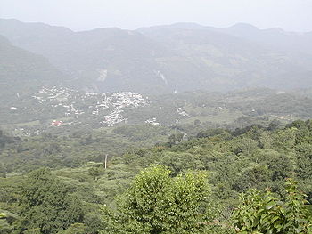
. Xilitla is known for its fertile mountains and springs, which create panoramic landscapes throughout the municipality. The mountains have also partly shielded Xilitla from industrialization, helping preserve its indigenous Nahuatl
Nahuatl
Nahuatl is thought to mean "a good, clear sound" This language name has several spellings, among them náhuatl , Naoatl, Nauatl, Nahuatl, Nawatl. In a back formation from the name of the language, the ethnic group of Nahuatl speakers are called Nahua...
and Teenek cultures and traditional agrarian lifestyles. Most of Xilitla's 50,000 residents live in over 100 comunidades (communities)—rural villages of several dozen or up to several hundred people known as campesinos
Peasant
A peasant is an agricultural worker who generally tend to be poor and homeless-Etymology:The word is derived from 15th century French païsant meaning one from the pays, or countryside, ultimately from the Latin pagus, or outlying administrative district.- Position in society :Peasants typically...
. A few thousand people live in the municipality seat itself, also named Xilitla.
Geography
Xilitla is located in the Sierra Madre OrientalSierra Madre Oriental
The Sierra Madre Oriental is a mountain range in northeastern Mexico.-Setting:Spanning the Sierra Madre Oriental runs from Coahuila south through Nuevo León, southwest Tamaulipas, San Luis Potosí, Querétaro, and Hidalgo to northern Puebla, where it joins with the east-west running Eje Volcánico...
mountain range, with narrow valleys dipping to 400m and hilltops as high as 1400m above sea level. Its land area is 415km², which is largely steep but habitable slopes. To the south and west, Xilitla borders the mountains of Querétaro
Querétaro
Querétaro officially Estado Libre y Soberano de Querétaro de Arteaga is one of the 31 states which, with the Federal District, comprise the 32 Federal Entities of Mexico. It is divided into 18 municipalities and its capital city is Santiago de Querétaro....
and Hidalgo states. To the northeast, Xilitla borders flat terrain along the Tancuilin river, and Mexican highway 85.
There are a number of cave
Cave
A cave or cavern is a natural underground space large enough for a human to enter. The term applies to natural cavities some part of which is in total darkness. The word cave also includes smaller spaces like rock shelters, sea caves, and grottos.Speleology is the science of exploration and study...
s and caverns in Xilitla, as well as many natural spring
Spring (hydrosphere)
A spring—also known as a rising or resurgence—is a component of the hydrosphere. Specifically, it is any natural situation where water flows to the surface of the earth from underground...
s which provide potable water. The land is largely sedimentary rock
Sedimentary rock
Sedimentary rock are types of rock that are formed by the deposition of material at the Earth's surface and within bodies of water. Sedimentation is the collective name for processes that cause mineral and/or organic particles to settle and accumulate or minerals to precipitate from a solution....
with striations visible on cliffs and roads.
Climate
Transportation
Most of Xilitla's residents do not own vehicles. Instead, the rural communities count on one or two residents who make their living as independent drivers.(Needs Sources) Drivers own heavy-duty pickup truckPickup truck
A pickup truck is a light motor vehicle with an open-top rear cargo area .-Definition:...
s, outfitted to carry 20 or more passengers (compare songthaew
Songthaew
A songthaew , also known in English as a baht bus, is a passenger vehicle in Malaysia, Thailand and Laos adapted from a pick-up or a larger truck and used as a share taxi....
). These trucks make frequent unscheduled trips along the network of steep winding gravel roads, connecting remote communities with the town. From most communities, the trip to town takes about an hour and costs about 10 pesos.(Needs Sources)
The highway to the southwest winds around tight curves through the mountains to Querétaro
Querétaro
Querétaro officially Estado Libre y Soberano de Querétaro de Arteaga is one of the 31 states which, with the Federal District, comprise the 32 Federal Entities of Mexico. It is divided into 18 municipalities and its capital city is Santiago de Querétaro....
and Mexico City
Mexico City
Mexico City is the Federal District , capital of Mexico and seat of the federal powers of the Mexican Union. It is a federal entity within Mexico which is not part of any one of the 31 Mexican states but belongs to the federation as a whole...
. Heading northeast from town, the highway winds 10km to La Y Griega, a large T-intersection into highway 85. Ciudad Valles
Ciudad Valles
Ciudad Valles is the second-largest city in the Mexican state of San Luis Potosí. It is located in the eastern part of the state at . The city is also the municipal seat of the surrounding municipality of the same name. The city had a 2005 census population of 116,261, while the municipality's...
is 100km north along 85, and Tamazunchale
Tamazunchale
Tamazunchale is a town and municipality in the state of San Luis Potosí, central Mexico.-Etymology:The name Tamazunchale comes from the Huastec language, and means "Place of the Government"; it was the Huastec capital around the 1400s.-History:...
is 50km south. Buses run hourly from the town to Ciudad Valles
Ciudad Valles
Ciudad Valles is the second-largest city in the Mexican state of San Luis Potosí. It is located in the eastern part of the state at . The city is also the municipal seat of the surrounding municipality of the same name. The city had a 2005 census population of 116,261, while the municipality's...
and Tamazunchale
Tamazunchale
Tamazunchale is a town and municipality in the state of San Luis Potosí, central Mexico.-Etymology:The name Tamazunchale comes from the Huastec language, and means "Place of the Government"; it was the Huastec capital around the 1400s.-History:...
and several times daily to Monterrey
Monterrey
Monterrey , is the capital city of the northeastern state of Nuevo León in the country of Mexico. The city is anchor to the third-largest metropolitan area in Mexico and is ranked as the ninth-largest city in the nation. Monterrey serves as a commercial center in the north of the country and is the...
, Mexico City
Mexico City
Mexico City is the Federal District , capital of Mexico and seat of the federal powers of the Mexican Union. It is a federal entity within Mexico which is not part of any one of the 31 Mexican states but belongs to the federation as a whole...
, San Luis Potosí
San Luis Potosí, San Luis Potosí
San Luis Potosí, commonly called SLP or simply San Luis, is the capital of, and most populous city in the Mexican state of the same name. The city lies at an elevation of 1,850 meters...
and Tampico
Tampico
Tampico is a city and port in the state of Tamaulipas, in the country of Mexico. It is located in the southeastern part of the state, directly north across the border from Veracruz. Tampico is the third largest city in Tamaulipas, and counts with a population of 309,003. The Metropolitan area of...
. More frequent buses are available at Y Griega.
The most important agricultural activities are the cultivation of coffee and palmilla, an ornamental plant native to the region.
The natural beauty of the area, particularly Xilitla, has made it a source of inspiration of many people, among those Edward James
Edward James
Edward William Frank James was a British poet known for his patronage of the surrealist art movement.-Early life and marriage:...
, who built "Las Pozas", a surrealist
Surrealism
Surrealism is a cultural movement that began in the early 1920s, and is best known for the visual artworks and writings of the group members....
landscape, just outside the town. Filmmaker Antonino Isordia
Antonino Isordia
Antonino Isordia Llamazares is a Mexican film and documentary director known for making documentary films in a more cinematic style. His films have been shown at international film festivals and received awards in his native Mexico, Argentina, Austria, Canada, Chile, Colombia, Cuba, France,...
was born in Xilitla in 1973.
Xilitla is a bustling center and important meeting point for the people of the surrounding communities. Xilitla has a wide range of businesses including food, clothing, and shoe stores, restaurants (including the Comedor Popular, La Flor de Café) in addition to a bank, a telephone call center, and an internet café. The church is the largest structure in the town and is located on one edge of the main plaza. On Sundays, the market day, the town fills with people and energy and welcomes people from surrounding communities who come to buy and sell their agricultural and commercial products.
A local specialty is the zacahuitl, a giant tamale (3 to 4 feet long) wrapped in banana leaves and filled with pork on one side and chicken on the other.
External links
- Xilitla, Enciclopedia de los Municipios de México, Instituto Nacional para el Federalismo y el Desarrollo Municipal, SEGOB.
- About Xilitla - AFSCAmerican Friends Service CommitteeThe American Friends Service Committee is a Religious Society of Friends affiliated organization which works for peace and social justice in the United States and around the world...
info for international community service - Xilitla Map and Municipal Statistics (Spanish) - from the San Luis PotosíSan Luis PotosíSan Luis Potosí officially Estado Libre y Soberano de San Luis Potosí is one of the 31 states which, with the Federal District, comprise the 32 Federal Entities of Mexico. It is divided in 58 municipalities and its capital city is San Luis Potosí....
state government - Topographic Map - shows Xilitla in lower-left section