
Woodville, Ohio
Encyclopedia
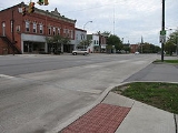
Woodville is a village in Sandusky County
, Ohio
, United States
. The population was 1,977 at the 2000 census. The National Arbor Day Foundation
has designated Woodville as a Tree City USA
.
with Lower Sandusky, which has since been renamed Fremont
.
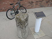 A mile marker from the road remains at 100 East Main Street, in front of the village pharmacy. Several of the milestone
s are still in place along the 31 miles (49.9 km) stretch between present day Fremont and Perrysburg. The route is currently designated U.S. Route 20
.
Woodville is also the point at which U.S. 20 crosses the Portage River
. The former Pennsylvania Railroad
also crossed the Portage River in Woodville. The line was at one time a main route from Toledo
to Pittsburgh.
A half mile upstream from the highway and the rail bridges lies Trailmarker Park. This is site of a shallow point in the river where Native Americans routinely crossed the Portage. A tree that was bent by Native Americans
to mark the crossing point had a large limb that stretched over the west bank of the river, just south of the Cherry Street bridge. However, the limb was mistakenly removed by village workers in the 1990s.
The origin of the name Woodville is often attributed to General Amos E. Wood
, for which nearby Wood County is named. However, it is unclear whether this is true.
State Route 105 also runs through Woodville.
According to the United States Census Bureau
, the village has a total area of 1.2 square miles (3.1 km²), all of it land.
of 2000, there were 1,977 people, 786 households, and 558 families residing in the village. The population density
was 1,585.7 people per square mile (610.7/km²). There were 815 housing units at an average density of 653.7 per square mile (251.7/km²). The racial makeup of the village was 97.67% White, 0.15% African American, 0.25% Native American, 0.86% from other races
, and 1.06% from two or more races. Hispanic or Latino of any race were 3.19% of the population.
There were 786 households out of which 37.0% had children under the age of 18 living with them, 59.8% were married couples
living together, 8.3% had a female householder with no husband present, and 28.9% were non-families. 25.4% of all households were made up of individuals and 14.2% had someone living alone who was 65 years of age or older. The average household size was 2.52 and the average family size was 3.04.
In the village the population was spread out with 27.8% under the age of 18, 5.6% from 18 to 24, 28.5% from 25 to 44, 22.5% from 45 to 64, and 15.6% who were 65 years of age or older. The median age was 38 years. For every 100 females there were 90.8 males. For every 100 females age 18 and over, there were 86.5 males.
The median income for a household in the village was $47,039, and the median income for a family was $56,467. Males had a median income of $38,793 versus $28,350 for females. The per capita income
for the village was $21,414. About 2.3% of families and 3.9% of the population were below the poverty line, including 4.3% of those under age 18 and 4.4% of those age 65 or over.
Immediately following the consolidation, students attended classes through fifth grade in their hometown, or the village nearest to their homes. A portion of the school in Woodville was used as a Middle School for grades 6-8 and the Elmore building was used as the High School for all students. In the early 1980s, all students in grades K-6 began attending school in Woodville and all students in grades 7-12 were moved to the high school in Elmore
.
Most of the high school was demolished, rebuilt and opened for the 1990-91 academic year. The original portion of the Elementary School dates back to the early 1900s.
Woodmore High School
athletic teams are called the Wildcats and compete in the Suburban Lakes League
.
Trailmarker Park is the largest. It is located along the west bank of the Portage River and is home to a public pool, several pieces of playground equipment and a boat ramp.
Veterans Memorial Park is also referred to locally as Waterworks Park because of its proximity to the water treatment plant on North Perry Street. The park features a memorial to soldiers, complete with a decommissioned cannon and is located on First Street between Walnut and Perry Streets. Playground equipment is also in place at Veterans Memorial Park.
Busdiecker Park was originally named Teardrop Park because of its shape. It is located at the intersection of Main Street (U. S. 20) and Findlay Road and is also bounded by the Portage River. Busdiecker Park features 13 flagpoles, one for each of the astronauts killed in the United States space program at the time of the park's renaming in the mid 1990s.
Sandusky County, Ohio
Sandusky County is a county in the U.S. state of Ohio. As of the 2010 census, the population was 60,944. Its county seat is Fremont and it is named for a native word meaning "water" ....
, Ohio
Ohio
Ohio is a Midwestern state in the United States. The 34th largest state by area in the U.S.,it is the 7th‑most populous with over 11.5 million residents, containing several major American cities and seven metropolitan areas with populations of 500,000 or more.The state's capital is Columbus...
, United States
United States
The United States of America is a federal constitutional republic comprising fifty states and a federal district...
. The population was 1,977 at the 2000 census. The National Arbor Day Foundation
National Arbor Day Foundation
The Arbor Day Foundation is the world's oldest and largest tree-planting organization. The foundation began September 3, 1971 with a mission "to inspire people to plant, nurture, and celebrate trees". The Foundation is supported by donations, selling trees and merchandise, and by corporate sponsors...
has designated Woodville as a Tree City USA
Tree City USA
Tree City USA is a tree planting and tree care program sponsored by the National Arbor Day Foundation for cities and towns in the United States.- Requirements :...
.
History
Woodville was incorporated in 1836 and is the midway point on the Western Reserve and Maumee Turnpike, which was also known as the "Old Mud Pike" because of the thick mud that often mired animals and vehicles alike. It was the first permanent route across the Black Swamp. The toll road connected PerrysburgPerrysburg, Ohio
As of the census of 2000, there were 16,945 people, 6,592 households, and 4,561 families residing in the city. The population density was 1,899.2 people per square mile . There were 6,964 housing units at an average density of 780.5 per square mile...
with Lower Sandusky, which has since been renamed Fremont
Fremont, Ohio
Fremont Public Schools enroll 4,450 students in public primary and secondary schools. The district administers 9 public schools including seven elementary schools, one middle school, and one high school, Fremont Ross. In addition, the city is home to one private catholic high school, Saint Joseph...
.
Milestone
A milestone is one of a series of numbered markers placed along a road or boundary at intervals of one mile or occasionally, parts of a mile. They are typically located at the side of the road or in a median. They are alternatively known as mile markers, mileposts or mile posts...
s are still in place along the 31 miles (49.9 km) stretch between present day Fremont and Perrysburg. The route is currently designated U.S. Route 20
U.S. Route 20
U.S. Route 20 is an east–west United States highway. As the "0" in its route number implies, US 20 is a coast-to-coast route. Spanning , it is the longest road in the United States, and the route sparsely parallels Interstate 90...
.
Woodville is also the point at which U.S. 20 crosses the Portage River
Portage River (Ohio)
Approximately in length, the Portage River meanders across Ottawa, Sandusky, and Wood counties in northwest Ohio before it empties into Lake Erie at Port Clinton...
. The former Pennsylvania Railroad
Pennsylvania Railroad
The Pennsylvania Railroad was an American Class I railroad, founded in 1846. Commonly referred to as the "Pennsy", the PRR was headquartered in Philadelphia, Pennsylvania....
also crossed the Portage River in Woodville. The line was at one time a main route from Toledo
Toledo, Ohio
Toledo is the fourth most populous city in the U.S. state of Ohio and is the county seat of Lucas County. Toledo is in northwest Ohio, on the western end of Lake Erie, and borders the State of Michigan...
to Pittsburgh.
A half mile upstream from the highway and the rail bridges lies Trailmarker Park. This is site of a shallow point in the river where Native Americans routinely crossed the Portage. A tree that was bent by Native Americans
Native Americans in the United States
Native Americans in the United States are the indigenous peoples in North America within the boundaries of the present-day continental United States, parts of Alaska, and the island state of Hawaii. They are composed of numerous, distinct tribes, states, and ethnic groups, many of which survive as...
to mark the crossing point had a large limb that stretched over the west bank of the river, just south of the Cherry Street bridge. However, the limb was mistakenly removed by village workers in the 1990s.
The origin of the name Woodville is often attributed to General Amos E. Wood
Amos E. Wood
Amos Eastman Wood was a U.S. Representative from Ohio.Born in Ellisburg, New York, Wood attended the common schools. He moved to Sandusky County, Ohio, in 1833 and engaged in agricultural pursuits...
, for which nearby Wood County is named. However, it is unclear whether this is true.
State Route 105 also runs through Woodville.
Geography
Woodville is located at 41°27′4"N 83°21′57"W (41.451093, -83.365967).According to the United States Census Bureau
United States Census Bureau
The United States Census Bureau is the government agency that is responsible for the United States Census. It also gathers other national demographic and economic data...
, the village has a total area of 1.2 square miles (3.1 km²), all of it land.
Demographics
As of the censusCensus
A census is the procedure of systematically acquiring and recording information about the members of a given population. It is a regularly occurring and official count of a particular population. The term is used mostly in connection with national population and housing censuses; other common...
of 2000, there were 1,977 people, 786 households, and 558 families residing in the village. The population density
Population density
Population density is a measurement of population per unit area or unit volume. It is frequently applied to living organisms, and particularly to humans...
was 1,585.7 people per square mile (610.7/km²). There were 815 housing units at an average density of 653.7 per square mile (251.7/km²). The racial makeup of the village was 97.67% White, 0.15% African American, 0.25% Native American, 0.86% from other races
Race (United States Census)
Race and ethnicity in the United States Census, as defined by the Federal Office of Management and Budget and the United States Census Bureau, are self-identification data items in which residents choose the race or races with which they most closely identify, and indicate whether or not they are...
, and 1.06% from two or more races. Hispanic or Latino of any race were 3.19% of the population.
There were 786 households out of which 37.0% had children under the age of 18 living with them, 59.8% were married couples
Marriage
Marriage is a social union or legal contract between people that creates kinship. It is an institution in which interpersonal relationships, usually intimate and sexual, are acknowledged in a variety of ways, depending on the culture or subculture in which it is found...
living together, 8.3% had a female householder with no husband present, and 28.9% were non-families. 25.4% of all households were made up of individuals and 14.2% had someone living alone who was 65 years of age or older. The average household size was 2.52 and the average family size was 3.04.
In the village the population was spread out with 27.8% under the age of 18, 5.6% from 18 to 24, 28.5% from 25 to 44, 22.5% from 45 to 64, and 15.6% who were 65 years of age or older. The median age was 38 years. For every 100 females there were 90.8 males. For every 100 females age 18 and over, there were 86.5 males.
The median income for a household in the village was $47,039, and the median income for a family was $56,467. Males had a median income of $38,793 versus $28,350 for females. The per capita income
Per capita income
Per capita income or income per person is a measure of mean income within an economic aggregate, such as a country or city. It is calculated by taking a measure of all sources of income in the aggregate and dividing it by the total population...
for the village was $21,414. About 2.3% of families and 3.9% of the population were below the poverty line, including 4.3% of those under age 18 and 4.4% of those age 65 or over.
Schools
Woodville and the surrounding Woodville Township are part of the Woodmore Local School District. Until 1967, Woodville had its own school district and the athletic teams were known as the Warriors, with a Native American mascot. In 1967, Woodville's school absorbed the Harris-Elmore Local Schools and the name of the district was changed to Woodmore. Elmore's athletic teams formerly competed as the Bulldogs.Immediately following the consolidation, students attended classes through fifth grade in their hometown, or the village nearest to their homes. A portion of the school in Woodville was used as a Middle School for grades 6-8 and the Elmore building was used as the High School for all students. In the early 1980s, all students in grades K-6 began attending school in Woodville and all students in grades 7-12 were moved to the high school in Elmore
Elmore, Ohio
Elmore is a village in Ottawa and Sandusky counties in the U.S. state of Ohio. The population was 1,426 at the 2000 census.The Ottawa County portion of Elmore is part of the Toledo Metropolitan Statistical Area, while the Sandusky County portion is part of the Fremont Micropolitan Statistical...
.
Most of the high school was demolished, rebuilt and opened for the 1990-91 academic year. The original portion of the Elementary School dates back to the early 1900s.
Woodmore High School
Woodmore High School
Woodmore High School is a public high school in Elmore, Ohio. It is the only high school in the Woodmore Local Schools district, which also serves Woodville, Ohio. Their nickname is the Wildcats...
athletic teams are called the Wildcats and compete in the Suburban Lakes League
Suburban Lakes League
The Suburban Lakes League was an OHSAA athletic league with 7 member schools located in northwest Ohio. The league was formed in 1972 by former members of the Northern Lakes League, Sandusky Bay Conference, and the Lakeshore Conference....
.
Industry
Limestone is the primary export of Woodville. Two quarries located in Woodville Township each rank in the top ten in size in the United States among lime quarries.Recreation
There are three public parks in Woodville:Trailmarker Park is the largest. It is located along the west bank of the Portage River and is home to a public pool, several pieces of playground equipment and a boat ramp.
Veterans Memorial Park is also referred to locally as Waterworks Park because of its proximity to the water treatment plant on North Perry Street. The park features a memorial to soldiers, complete with a decommissioned cannon and is located on First Street between Walnut and Perry Streets. Playground equipment is also in place at Veterans Memorial Park.
Busdiecker Park was originally named Teardrop Park because of its shape. It is located at the intersection of Main Street (U. S. 20) and Findlay Road and is also bounded by the Portage River. Busdiecker Park features 13 flagpoles, one for each of the astronauts killed in the United States space program at the time of the park's renaming in the mid 1990s.
Notable residents
- Terence T. HenricksTerence T. HenricksTerence Thomas "Tom" Henricks is a retired colonel in the United States Air Force and a former NASA astronaut. He served on four Space Shuttle missions.-Personal data:...
, astronaut - Jon GieslerJon GieslerJon William Giesler is a former American football offensive tackle who played ten seasons with the Miami Dolphins of the NFL. He was selected by the Dolphins in the first round as the 24th overall pick in the 1979 NFL Draft....
, former offensive tackleAmerican football positionsIn American football, each team has eleven players on the field at one time. Because the rules allow unlimited substitution between plays, the types of players on the field for each team differ depending on the situation...
for the Miami DolphinsMiami DolphinsThe Miami Dolphins are a Professional football team based in the Miami metropolitan area in Florida. The team is part of the Eastern Division of the American Football Conference in the National Football League...