
Woodstock, New Hampshire
Encyclopedia
Woodstock is a town in Grafton County
, New Hampshire
, United States. The population was 1,374 at the 2010 census. Woodstock includes the village of North Woodstock
, the commercial center. Its extensive land area is largely forested, and includes the Hubbard Brook Experimental Forest
. Parts of the White Mountain National Forest
are in the east and west. The Appalachian Trail
crosses the town's northwest corner. Russell Pond Campground is in the east. West of North Woodstock is the Lost River Reservation
.
Governor Benning Wentworth
named the town Peeling after an English
town. Many of the first colonists were originally from Lebanon
, Connecticut
. In 1771, his nephew, Governor John Wentworth
, gave it the name Fairfield, after Fairfield
, Connecticut
. The town was renamed Woodstock in 1840 for Blenheim Palace
in Woodstock, England.
Logging
became a principal early industry, with sawmill
s established using water power from the Pemigewasset River
. The entrance of the railroad in the 19th century opened the wilderness
to development, carrying away wood products to market. It also brought tourists, many attracted by paintings of the White Mountains
by White Mountain art
ists. Several inns and hotels were built to accommodate the wealthy, who sought relief from the summer heat, humidity and pollution of coal-age Boston, Hartford
, New York
and Philadelphia. They often relaxed by taking carriage
rides through the White Mountains
, or by hiking along the Lost River
in Lost River Reservation
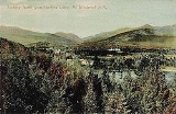
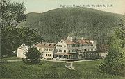
. But with the advent of automobiles, patrons were no longer restricted by the limits of rail service. Consequently, many grand hotels established near depots declined and closed. Woodstock, however, remains a popular tourist destination
.
The Hubbard Brook Experimental Forest
, an outdoor laboratory for ecological
studies founded by the United States Forest Service
in 1955, is located in the southern part of town.
, the town has a total area of 59.2 square miles (153.3 km²), of which 58.7 sq mi (152 km²) is land and 0.5 sq mi (1.3 km²) is water, comprising 0.84% of the town. Woodstock is drained by the Pemigewasset River. The town's highest point is the summit of Mount Jim, at 4172 feet (1,271.6 m) above sea level
, a spur of Mount Moosilauke.
Woodstock is crossed by Interstate 93
, U.S. Route 3, New Hampshire Route 112
and New Hampshire Route 175
.
 As of the census
of 2000, there were 1,139 people, 500 households, and 278 families residing in the town. The population density
was 19.4 people per square mile (7.5/km²). There were 1,264 housing units at an average density of 21.5 per square mile (8.3/km²). The racial makeup of the town was 97.37% White, 0.09% African American, 0.35% Native American, 0.18% Asian, 0.53% from other races
, and 1.49% from two or more races. Hispanic or Latino of any race were 0.70% of the population.
There were 500 households out of which 29.0% had children under the age of 18 living with them, 42.0% were married couples
living together, 8.2% had a female householder with no husband present, and 44.2% were non-families. 33.8% of all households were made up of individuals and 10.0% had someone living alone who was 65 years of age or older. The average household size was 2.28 and the average family size was 2.92.
In the town the population was spread out with 23.8% under the age of 18, 7.5% from 18 to 24, 33.4% from 25 to 44, 25.1% from 45 to 64, and 10.3% who were 65 years of age or older. The median age was 37 years. For every 100 females there were 101.6 males. For every 100 females age 18 and over, there were 101.9 males.
The median income for a household in the town was $35,556, and the median income for a family was $40,875. Males had a median income of $29,539 versus $23,750 for females. The per capita income
for the town was $19,973. About 7.6% of families and 9.6% of the population were below the poverty line, including 14.8% of those under age 18 and 14.0% of those age 65 or over.
Grafton County, New Hampshire
Grafton County is a county located in the U.S. state of New Hampshire. As of the 2010 census, the population was 89,118. Its county seat is North Haverhill, which is a village within the town of Haverhill. Until 1972, the county courthouse and other offices were located in downtown Woodsville, a...
, New Hampshire
New Hampshire
New Hampshire is a state in the New England region of the northeastern United States of America. The state was named after the southern English county of Hampshire. It is bordered by Massachusetts to the south, Vermont to the west, Maine and the Atlantic Ocean to the east, and the Canadian...
, United States. The population was 1,374 at the 2010 census. Woodstock includes the village of North Woodstock
North Woodstock, New Hampshire
North Woodstock is a census-designated place in the town of Woodstock in Grafton County, New Hampshire. It had a population of 528 at the 2010 census....
, the commercial center. Its extensive land area is largely forested, and includes the Hubbard Brook Experimental Forest
Hubbard Brook Experimental Forest
Hubbard Brook Experimental Forest is an area of land in the White Mountains of New Hampshire that functions as an outdoor laboratory for ecological studies...
. Parts of the White Mountain National Forest
White Mountain National Forest
The White Mountain National Forest is a federally-managed forest contained within the White Mountains in the northeastern United States. It was established in 1918 as a result of the Weeks Act of 1911; federal acquisition of land had already begun in 1914. It has a total area of...
are in the east and west. The Appalachian Trail
Appalachian Trail
The Appalachian National Scenic Trail, generally known as the Appalachian Trail or simply the AT, is a marked hiking trail in the eastern United States extending between Springer Mountain in Georgia and Mount Katahdin in Maine. It is approximately long...
crosses the town's northwest corner. Russell Pond Campground is in the east. West of North Woodstock is the Lost River Reservation
Lost River Reservation
The Lost River Reservation is a series of caves in the White Mountains in Woodstock, New Hampshire, United States. Located west of the village of North Woodstock on New Hampshire Route 112, Lost River Reservation is set in Kinsman Notch...
.
History
First granted in 1763, ColonialColony
In politics and history, a colony is a territory under the immediate political control of a state. For colonies in antiquity, city-states would often found their own colonies. Some colonies were historically countries, while others were territories without definite statehood from their inception....
Governor Benning Wentworth
Benning Wentworth
Benning Wentworth was the colonial governor of New Hampshire from 1741 to 1766.-Biography:The eldest child of the John Wentworth who had been Lieutenant Governor, he was born and died in Portsmouth, New Hampshire. Wentworth graduated from Harvard College in 1715...
named the town Peeling after an English
England
England is a country that is part of the United Kingdom. It shares land borders with Scotland to the north and Wales to the west; the Irish Sea is to the north west, the Celtic Sea to the south west, with the North Sea to the east and the English Channel to the south separating it from continental...
town. Many of the first colonists were originally from Lebanon
Lebanon, Connecticut
Lebanon is a town in New London County, Connecticut, United States. The population was 6,907 at the 2000 census. The town lies just to the northwest of Norwich, north of New London, and east of Hartford...
, Connecticut
Connecticut
Connecticut is a state in the New England region of the northeastern United States. It is bordered by Rhode Island to the east, Massachusetts to the north, and the state of New York to the west and the south .Connecticut is named for the Connecticut River, the major U.S. river that approximately...
. In 1771, his nephew, Governor John Wentworth
John Wentworth (governor)
Sir John Wentworth, 1st Baronet was the British colonial governor of New Hampshire at the time of the American Revolution. He was later also Lieutenant-Governor of Nova Scotia.-Early life:...
, gave it the name Fairfield, after Fairfield
Fairfield, Connecticut
Fairfield is a town located in Fairfield County, Connecticut, United States. It is bordered by the towns of Bridgeport, Trumbull, Easton, Redding and Westport along the Gold Coast of Connecticut. As of the 2010 census, the town had a population of 59,404...
, Connecticut
Connecticut
Connecticut is a state in the New England region of the northeastern United States. It is bordered by Rhode Island to the east, Massachusetts to the north, and the state of New York to the west and the south .Connecticut is named for the Connecticut River, the major U.S. river that approximately...
. The town was renamed Woodstock in 1840 for Blenheim Palace
Blenheim Palace
Blenheim Palace is a monumental country house situated in Woodstock, Oxfordshire, England, residence of the dukes of Marlborough. It is the only non-royal non-episcopal country house in England to hold the title of palace. The palace, one of England's largest houses, was built between...
in Woodstock, England.
Logging
Logging
Logging is the cutting, skidding, on-site processing, and loading of trees or logs onto trucks.In forestry, the term logging is sometimes used in a narrow sense concerning the logistics of moving wood from the stump to somewhere outside the forest, usually a sawmill or a lumber yard...
became a principal early industry, with sawmill
Sawmill
A sawmill is a facility where logs are cut into boards.-Sawmill process:A sawmill's basic operation is much like those of hundreds of years ago; a log enters on one end and dimensional lumber exits on the other end....
s established using water power from the Pemigewasset River
Pemigewasset River
The Pemigewasset River , known locally as "The Pemi", is a river in the state of New Hampshire, the United States. It is in length and drains approximately...
. The entrance of the railroad in the 19th century opened the wilderness
Wilderness
Wilderness or wildland is a natural environment on Earth that has not been significantly modified by human activity. It may also be defined as: "The most intact, undisturbed wild natural areas left on our planet—those last truly wild places that humans do not control and have not developed with...
to development, carrying away wood products to market. It also brought tourists, many attracted by paintings of the White Mountains
White Mountains (New Hampshire)
The White Mountains are a mountain range covering about a quarter of the state of New Hampshire and a small portion of western Maine in the United States. Part of the Appalachian Mountains, they are considered the most rugged mountains in New England...
by White Mountain art
White Mountain art
White Mountain art is the body of work created during the 19th century by over four hundred artists who painted landscape scenes of the White Mountains of New Hampshire in order to promote the region and, consequently, sell their works of art....
ists. Several inns and hotels were built to accommodate the wealthy, who sought relief from the summer heat, humidity and pollution of coal-age Boston, Hartford
Hartford, Connecticut
Hartford is the capital of the U.S. state of Connecticut. The seat of Hartford County until Connecticut disbanded county government in 1960, it is the second most populous city on New England's largest river, the Connecticut River. As of the 2010 Census, Hartford's population was 124,775, making...
, New York
New York City
New York is the most populous city in the United States and the center of the New York Metropolitan Area, one of the most populous metropolitan areas in the world. New York exerts a significant impact upon global commerce, finance, media, art, fashion, research, technology, education, and...
and Philadelphia. They often relaxed by taking carriage
Carriage
A carriage is a wheeled vehicle for people, usually horse-drawn; litters and sedan chairs are excluded, since they are wheelless vehicles. The carriage is especially designed for private passenger use and for comfort or elegance, though some are also used to transport goods. It may be light,...
rides through the White Mountains
White Mountains (New Hampshire)
The White Mountains are a mountain range covering about a quarter of the state of New Hampshire and a small portion of western Maine in the United States. Part of the Appalachian Mountains, they are considered the most rugged mountains in New England...
, or by hiking along the Lost River
Lost River (New Hampshire)
The Lost River is a stream located in the White Mountains of New Hampshire in the United States. It is a tributary of the Pemigewasset River, part of the Merrimack River watershed....
in Lost River Reservation
Lost River Reservation
The Lost River Reservation is a series of caves in the White Mountains in Woodstock, New Hampshire, United States. Located west of the village of North Woodstock on New Hampshire Route 112, Lost River Reservation is set in Kinsman Notch...
. But with the advent of automobiles, patrons were no longer restricted by the limits of rail service. Consequently, many grand hotels established near depots declined and closed. Woodstock, however, remains a popular tourist destination
Tourist destination
A tourist destination is a city, town, or other area that is dependent to a significant extent on the revenues accruing from tourism. It may contain one or more tourist attractions and possibly some "tourist traps."...
.
The Hubbard Brook Experimental Forest
Hubbard Brook Experimental Forest
Hubbard Brook Experimental Forest is an area of land in the White Mountains of New Hampshire that functions as an outdoor laboratory for ecological studies...
, an outdoor laboratory for ecological
Ecology
Ecology is the scientific study of the relations that living organisms have with respect to each other and their natural environment. Variables of interest to ecologists include the composition, distribution, amount , number, and changing states of organisms within and among ecosystems...
studies founded by the United States Forest Service
United States Forest Service
The United States Forest Service is an agency of the United States Department of Agriculture that administers the nation's 155 national forests and 20 national grasslands, which encompass...
in 1955, is located in the southern part of town.
Geography
According to the United States Census BureauUnited States Census Bureau
The United States Census Bureau is the government agency that is responsible for the United States Census. It also gathers other national demographic and economic data...
, the town has a total area of 59.2 square miles (153.3 km²), of which 58.7 sq mi (152 km²) is land and 0.5 sq mi (1.3 km²) is water, comprising 0.84% of the town. Woodstock is drained by the Pemigewasset River. The town's highest point is the summit of Mount Jim, at 4172 feet (1,271.6 m) above sea level
Sea level
Mean sea level is a measure of the average height of the ocean's surface ; used as a standard in reckoning land elevation...
, a spur of Mount Moosilauke.
Woodstock is crossed by Interstate 93
Interstate 93
Interstate 93 is an Interstate Highway in the New England section of the United States. Its southern terminus is in Canton, Massachusetts, in the Boston metropolitan area, at Interstate 95; its northern terminus is near St. Johnsbury, Vermont, at Interstate 91...
, U.S. Route 3, New Hampshire Route 112
New Hampshire Route 112
New Hampshire Route 112 is a long east–west state highway in northern New Hampshire. The highway winds across the state, connecting Bath to Conway via the scenic and mountainous area of the White Mountain National Forest. Part of this highway, which runs through the White Mountains, is known as...
and New Hampshire Route 175
New Hampshire Route 175
New Hampshire Route 175 is a long north–south state highway in Grafton County in central New Hampshire. The highway winds from Holderness in the Lakes Region, north along the Pemigewasset River, to Woodstock in the White Mountains Region...
.
Demographics
Census
A census is the procedure of systematically acquiring and recording information about the members of a given population. It is a regularly occurring and official count of a particular population. The term is used mostly in connection with national population and housing censuses; other common...
of 2000, there were 1,139 people, 500 households, and 278 families residing in the town. The population density
Population density
Population density is a measurement of population per unit area or unit volume. It is frequently applied to living organisms, and particularly to humans...
was 19.4 people per square mile (7.5/km²). There were 1,264 housing units at an average density of 21.5 per square mile (8.3/km²). The racial makeup of the town was 97.37% White, 0.09% African American, 0.35% Native American, 0.18% Asian, 0.53% from other races
Race (United States Census)
Race and ethnicity in the United States Census, as defined by the Federal Office of Management and Budget and the United States Census Bureau, are self-identification data items in which residents choose the race or races with which they most closely identify, and indicate whether or not they are...
, and 1.49% from two or more races. Hispanic or Latino of any race were 0.70% of the population.
There were 500 households out of which 29.0% had children under the age of 18 living with them, 42.0% were married couples
Marriage
Marriage is a social union or legal contract between people that creates kinship. It is an institution in which interpersonal relationships, usually intimate and sexual, are acknowledged in a variety of ways, depending on the culture or subculture in which it is found...
living together, 8.2% had a female householder with no husband present, and 44.2% were non-families. 33.8% of all households were made up of individuals and 10.0% had someone living alone who was 65 years of age or older. The average household size was 2.28 and the average family size was 2.92.
In the town the population was spread out with 23.8% under the age of 18, 7.5% from 18 to 24, 33.4% from 25 to 44, 25.1% from 45 to 64, and 10.3% who were 65 years of age or older. The median age was 37 years. For every 100 females there were 101.6 males. For every 100 females age 18 and over, there were 101.9 males.
The median income for a household in the town was $35,556, and the median income for a family was $40,875. Males had a median income of $29,539 versus $23,750 for females. The per capita income
Per capita income
Per capita income or income per person is a measure of mean income within an economic aggregate, such as a country or city. It is calculated by taking a measure of all sources of income in the aggregate and dividing it by the total population...
for the town was $19,973. About 7.6% of families and 9.6% of the population were below the poverty line, including 14.8% of those under age 18 and 14.0% of those age 65 or over.