
Woodbridge, Ontario
Encyclopedia
Woodbridge is a large suburban community in the City of Vaughan
, just north of Toronto
in Southern Ontario
. It was once an independent town before being amalgamated with nearby communities to form the city in 1971. Its traditional downtown core is the Woodbridge Ave. stretch between Islington Avenue and Kipling Avenue
north of Highway 407
.
, Woodbridge rests at an average elevation of 200 metres between Highway 27 and Pine Valley Drive. The terrain can be described as a series of rolling hills and valleys requiring plenty of planning when road construction projects are initiated. There are numerous valley intersections that demonstrate the geography of the area, notably Highway 7 and Islington and Highway 27 and Rutherford.
The area was mainly farmland
before the onset of suburbanization
in the 1970s, but the residential communities are interspersed with forests along the Humber River
and its eastern branch. Today, much of the area is residential with commercial and industrial properties to the south, close to the border with the City of Toronto
and to the east near Pine Valley Drive.
Dfa), with warm, humid summers and cold, snowy winters. Woodbridge winters feature cold snaps where maximum temperatures remain below −10 °C (14 °F), often made to feel colder by wind chill. Accumulating snow can fall any time from November until mid-April. Summer in Woodbridge is characterized by long stretches of humid weather. Spring and autumn are transitional seasons, with generally mild or cool temperatures and alternating dry and wet periods. According to the USDA plant hardiness level, Woodbridge is 5a.
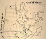
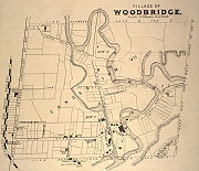 The community had its origins with the British Crown granting the west half of lots six and seven, concession 7 of Vaughan Township to Jacob Philips and Hugh Cameron in 1802. During the early half the 19th century, a school was built on Vaughan's eighth concession, a flour mill and store flourished at Pine Grove which is among the oldest areas of the city. A scattering of houses arose around Smith's mill (presently Hayhoe Mills on Pine Grove). Smith's mill later became known as Smithsville, but was eventually incorporated into the town of Woodbridge. A similar settlement, known as Brownsville, came into being around a mill run by John Brown on the Humber River on what is today Wallace Street in today's downtown Woodbridge business section. Woodbridge proper, however, did not begin to take the form of a settlement or village until the arrival of Rowland Burr in 1837. The town's name was changed to Woodbridge in 1855 because there was already a settlement named Burrwick. The name was taken from the wooden bridge that crossed the Humber River as an entry point into town. The historic bridge was located close to what is today Islington Avenue and Langstaff Road, on Langstaff looking north. A replica bridge circa 1930 made out of concrete remains close to the original bridge location and is accessible from Boyd Park and to a city maintenance facility. However, it has not been maintained for decades and is dangerous to stand on.
The Toronto, Grey and Bruce Railway arrived from Weston in 1870. This line was constructed as a narrow gauge railway through Caledon and completed to Owen Sound in 1873. Owing to financial difficulty, it was operated by the Grand Trunk Railway
until 1883, when it was leased to the Canadian Pacific Railway
. Conversion to standard gauge required realigning some of the track curves, particularly around Woodbridge. In 1908 this line was linked to the transcontinental route through Sudbury, while the original route between Bolton and Orangeville, was abandoned in 1934.
Woodbridge was also served by a branch of the Toronto Suburban Railway
until the 1930s. The Radial railway from Weston came in along the west side of the river, north of Humber Summit
, after descending from its route along Albion Road and Kipling Avenue.
Construction of Highway 7 began in the 1920s, passing south of the business section and through an underpass of the Canadian Pacific. The original railway bridge spanned the valley of the Humber River, while construction of Highway 407 has undermined the banks of the river on both sides, requiring a third overpass for the railway.Hurricane Hazel
in the 1950s ruined a bridge over Highway 7 and devastated much of the community. During much of this time, the land surrounding much of Woodbridge was used for farming. Slowly the area became populated with custom country houses.
 In the 1950s, Woodbridge experienced growth from suburban Toronto
houses. The suburban expansion began east of the Humber and East Humber and to the northeast. Prior to the expansion, the urban area was up to Kipling Avenue and to the Humber. It later expanded in the west up to Martin Grove Road with a north to south width of about 800 m in the 1960s and to the north and portions of the northeast of Langstaff Road. It later expanded north in the 1970s and the 1980s. A drive-in theatre from the 60s-70s was situated at Highway 27 and Langstaff near Martin Grove Road for many years until it was torn down in the late 1990s for residential houses. The housing developments in the west expanded north to Langstaff and in the central part of Woodbridge including a part which transformed older stores into smaller units of housing in the early-1980s and west to Highway 27 in the late-1980s and in 1992. The houses expanded north to 400 m south of Rutherford Road in the 1980s and east up to Weston Road from Highway 7 to 400 m south of Rutherford Road and south to 200 m north of the present-day Highway 407. The Industrial areas began appearing first to the west and then to the southwest and to the east.
The housing developments in mid-1990s expanded Martin Grove Road northward. Woodbridge Highlands was formed in the northwest, east of Highway 27 in the 1990s. In 1994 housing developments reached to Rutherford and continued until 1996 except for the northeast and the southeastern part. The condominiums began construction and now appear between Woodbridge Avenue and the Humber. Sonoma Heights at Islington and Rutherford and the Vellore area at Weston and Rutherford have been developed. The Vellore area includes Vellore Village developed by builders such as Greenpark Homes, Aspen Ridge Homes and Remington Homes. The Vellore Woods area was developed by Arista Homes and Fieldgate Homes. Development in the west end of Woodbridge then followed with Weston Rd and Rutherford becoming a major focal point for the building of additional residential units stretching north to Major Mackenzie. Land on both sides of Weston Road to Major Mackenzie were completely filled in. As an example of the scope of the development process, as of 2009 the entire area between Pine Valley Drive and Jane Street from Rutherford to Teston Road will eventually become houses. Houses were also built inside the Islington, Hwy 27, Major Mackenzie, and Rutherford quadrant. In addition, Vaughan Mills and a newer business section occupy the lands east of the 400, south of Rutherford. It is estimated that over 15,000 homes were built in less than 12 years with continued growth expected. All of these areas were previously fields less than 10 years ago with Canada's Wonderland previously sitting adjacent to hectares of empty farm land.
Woodbridge Avenue between Islington Avenue and Kipling Avenue was once home to some of the historical buildings from the late 19th century in addition to newer 1920s-1960s buildings, but is rapidly being reconstructed. Two examples of a histoic buildings include a Tinsmith Shop and Masonic Lodge (circa 1850) and the Burwick family home (from 1844 on Pine Street) that were moved to Black Creek Pioneer Village. Market Lane remains the commercial hub of this area, with several other shops and stores lining Woodbridge Avenue. Since 2000, there has been an increase in condominiums and apartment buildings on the historic avenue. Much of the avenue will be dominated by condominiums in the future as previous landowners have sold to developers.
The population was 3,000 until the 1950s, it reached 10,000 in the 1960s, 20,000 in the 1980s, 40,000 in the mid-1980s, 50,000 in the early 1990s, 60,000 in 1997 or 1998, and 70,000 in the 2000s, in the late 2000s, it is slightly over 100,000.
On August 20, 2009, a Tornado struck certain streets of Woodbridge, ripping off roofs from houses and leaving other buildings severely damaged.
 Woodbridge has no political boundaries, but is commonly viewed as lying between either Highway 50 or Highway 27 to the west, Steeles Avenue
to the south, Highway 400 to the east, and Major Mackenzie Drive to the north. However, new housing subdivisions being built north of Major Mackenzie between Pine Valley and the 400, have been given names like "Woodbridge Retreat" by developers, and will most likely extend the popularly accepted northeast boundary northwards to Teston Road.
Although Woodbridge is home to a large Italian-Canadian population, the area has seen an increase in almost every population from nations worldwide. Woodbridge is also considered by many law enforcement agencies and the community alike to be a hub for street racing in the GTA. Documentaries have aired on A&E (Inside Story: Street Racing: The Need For Speed) about the magnitude and organization of the street racing issue in Woodbridge.
:
Vaughan, Ontario
Vaughan is a city in York Region north of Toronto, Ontario, Canada. Vaughan is the fastest growing municipality in Canada achieving a population growth rate of 80.2% between 1996–2006, according to Statistics Canada having nearly doubled in population since 1991. Vaughan is located in Southern...
, just north of Toronto
Toronto
Toronto is the provincial capital of Ontario and the largest city in Canada. It is located in Southern Ontario on the northwestern shore of Lake Ontario. A relatively modern city, Toronto's history dates back to the late-18th century, when its land was first purchased by the British monarchy from...
in Southern Ontario
Southern Ontario
Southern Ontario is a region of the province of Ontario, Canada that lies south of the French River and Algonquin Park. Depending on the inclusion of the Parry Sound and Muskoka districts, its surface area would cover between 14 to 15% of the province. It is the southernmost region of...
. It was once an independent town before being amalgamated with nearby communities to form the city in 1971. Its traditional downtown core is the Woodbridge Ave. stretch between Islington Avenue and Kipling Avenue
Kipling Avenue
Kipling Avenue, originally named Mimico Avenue, is a street in the Etobicoke district of Toronto, Ontario, Canada. It is a concession road, 6 concessions from Yonge Street, and is a major north–south arterial road that also extends beyond Toronto, into the Regional Municipality of York.The...
north of Highway 407
Highway 7 (Ontario)
King's Highway 7, commonly referred to as Highway 7 and historically as the Northern Highway, is a provincially maintained highway in the Canadian province of Ontario...
.
Geography
Situated in hilly terrain of the Humber River ValleyHumber River (Ontario)
The Humber River is one of two major rivers on either side of Toronto, Ontario, Canada, the other being the Don River to the east. It was designated a Canadian Heritage River on September 24, 1999....
, Woodbridge rests at an average elevation of 200 metres between Highway 27 and Pine Valley Drive. The terrain can be described as a series of rolling hills and valleys requiring plenty of planning when road construction projects are initiated. There are numerous valley intersections that demonstrate the geography of the area, notably Highway 7 and Islington and Highway 27 and Rutherford.
The area was mainly farmland
Arable land
In geography and agriculture, arable land is land that can be used for growing crops. It includes all land under temporary crops , temporary meadows for mowing or pasture, land under market and kitchen gardens and land temporarily fallow...
before the onset of suburbanization
Suburbanization
Suburbanization a term used to describe the growth of areas on the fringes of major cities. It is one of the many causes of the increase in urban sprawl. Many residents of metropolitan regions work within the central urban area, choosing instead to live in satellite communities called suburbs...
in the 1970s, but the residential communities are interspersed with forests along the Humber River
Humber River (Ontario)
The Humber River is one of two major rivers on either side of Toronto, Ontario, Canada, the other being the Don River to the east. It was designated a Canadian Heritage River on September 24, 1999....
and its eastern branch. Today, much of the area is residential with commercial and industrial properties to the south, close to the border with the City of Toronto
Toronto
Toronto is the provincial capital of Ontario and the largest city in Canada. It is located in Southern Ontario on the northwestern shore of Lake Ontario. A relatively modern city, Toronto's history dates back to the late-18th century, when its land was first purchased by the British monarchy from...
and to the east near Pine Valley Drive.
Climate
Woodbridge has a humid continental climate (Koppen climate classificationKöppen climate classification
The Köppen climate classification is one of the most widely used climate classification systems. It was first published by Crimea German climatologist Wladimir Köppen in 1884, with several later modifications by Köppen himself, notably in 1918 and 1936...
Dfa), with warm, humid summers and cold, snowy winters. Woodbridge winters feature cold snaps where maximum temperatures remain below −10 °C (14 °F), often made to feel colder by wind chill. Accumulating snow can fall any time from November until mid-April. Summer in Woodbridge is characterized by long stretches of humid weather. Spring and autumn are transitional seasons, with generally mild or cool temperatures and alternating dry and wet periods. According to the USDA plant hardiness level, Woodbridge is 5a.
History
The Toronto, Grey and Bruce Railway arrived from Weston in 1870. This line was constructed as a narrow gauge railway through Caledon and completed to Owen Sound in 1873. Owing to financial difficulty, it was operated by the Grand Trunk Railway
Grand Trunk Railway
The Grand Trunk Railway was a railway system which operated in the Canadian provinces of Quebec and Ontario, as well as the American states of Connecticut, Maine, Michigan, Massachusetts, New Hampshire, and Vermont. The railway was operated from headquarters in Montreal, Quebec; however, corporate...
until 1883, when it was leased to the Canadian Pacific Railway
Canadian Pacific Railway
The Canadian Pacific Railway , formerly also known as CP Rail between 1968 and 1996, is a historic Canadian Class I railway founded in 1881 and now operated by Canadian Pacific Railway Limited, which began operations as legal owner in a corporate restructuring in 2001...
. Conversion to standard gauge required realigning some of the track curves, particularly around Woodbridge. In 1908 this line was linked to the transcontinental route through Sudbury, while the original route between Bolton and Orangeville, was abandoned in 1934.
Woodbridge was also served by a branch of the Toronto Suburban Railway
Toronto Suburban Railway
The Toronto Suburban Railway was an electric railway operator with local routes in west Toronto, and a radial route to Guelph.-History:...
until the 1930s. The Radial railway from Weston came in along the west side of the river, north of Humber Summit
Humber Summit
Humber Summit is one of the northernmost neighbourhoods in Toronto, Ontario, located in the North York district of the city. It is bounded by Steeles Avenue to the north, Highway 400 to the east, Finch Avenue to the south, and follows the Humber River to the west.-Character:In the 1840s, Humber...
, after descending from its route along Albion Road and Kipling Avenue.
Construction of Highway 7 began in the 1920s, passing south of the business section and through an underpass of the Canadian Pacific. The original railway bridge spanned the valley of the Humber River, while construction of Highway 407 has undermined the banks of the river on both sides, requiring a third overpass for the railway.Hurricane Hazel
Hurricane Hazel
Hurricane Hazel was the deadliest and costliest hurricane of the 1954 Atlantic hurricane season. The storm killed as many as 1,000 people in Haiti before striking the United States near the border between North and South Carolina, as a Category 4 hurricane...
in the 1950s ruined a bridge over Highway 7 and devastated much of the community. During much of this time, the land surrounding much of Woodbridge was used for farming. Slowly the area became populated with custom country houses.
Greater Toronto Area
The Greater Toronto Area is the largest metropolitan area in Canada, with a 2006 census population of 5.5 million. The Greater Toronto Area is usually defined as the central city of Toronto, along with four regional municipalities surrounding it: Durham, Halton, Peel, and York...
houses. The suburban expansion began east of the Humber and East Humber and to the northeast. Prior to the expansion, the urban area was up to Kipling Avenue and to the Humber. It later expanded in the west up to Martin Grove Road with a north to south width of about 800 m in the 1960s and to the north and portions of the northeast of Langstaff Road. It later expanded north in the 1970s and the 1980s. A drive-in theatre from the 60s-70s was situated at Highway 27 and Langstaff near Martin Grove Road for many years until it was torn down in the late 1990s for residential houses. The housing developments in the west expanded north to Langstaff and in the central part of Woodbridge including a part which transformed older stores into smaller units of housing in the early-1980s and west to Highway 27 in the late-1980s and in 1992. The houses expanded north to 400 m south of Rutherford Road in the 1980s and east up to Weston Road from Highway 7 to 400 m south of Rutherford Road and south to 200 m north of the present-day Highway 407. The Industrial areas began appearing first to the west and then to the southwest and to the east.
The housing developments in mid-1990s expanded Martin Grove Road northward. Woodbridge Highlands was formed in the northwest, east of Highway 27 in the 1990s. In 1994 housing developments reached to Rutherford and continued until 1996 except for the northeast and the southeastern part. The condominiums began construction and now appear between Woodbridge Avenue and the Humber. Sonoma Heights at Islington and Rutherford and the Vellore area at Weston and Rutherford have been developed. The Vellore area includes Vellore Village developed by builders such as Greenpark Homes, Aspen Ridge Homes and Remington Homes. The Vellore Woods area was developed by Arista Homes and Fieldgate Homes. Development in the west end of Woodbridge then followed with Weston Rd and Rutherford becoming a major focal point for the building of additional residential units stretching north to Major Mackenzie. Land on both sides of Weston Road to Major Mackenzie were completely filled in. As an example of the scope of the development process, as of 2009 the entire area between Pine Valley Drive and Jane Street from Rutherford to Teston Road will eventually become houses. Houses were also built inside the Islington, Hwy 27, Major Mackenzie, and Rutherford quadrant. In addition, Vaughan Mills and a newer business section occupy the lands east of the 400, south of Rutherford. It is estimated that over 15,000 homes were built in less than 12 years with continued growth expected. All of these areas were previously fields less than 10 years ago with Canada's Wonderland previously sitting adjacent to hectares of empty farm land.
Woodbridge Avenue between Islington Avenue and Kipling Avenue was once home to some of the historical buildings from the late 19th century in addition to newer 1920s-1960s buildings, but is rapidly being reconstructed. Two examples of a histoic buildings include a Tinsmith Shop and Masonic Lodge (circa 1850) and the Burwick family home (from 1844 on Pine Street) that were moved to Black Creek Pioneer Village. Market Lane remains the commercial hub of this area, with several other shops and stores lining Woodbridge Avenue. Since 2000, there has been an increase in condominiums and apartment buildings on the historic avenue. Much of the avenue will be dominated by condominiums in the future as previous landowners have sold to developers.
The population was 3,000 until the 1950s, it reached 10,000 in the 1960s, 20,000 in the 1980s, 40,000 in the mid-1980s, 50,000 in the early 1990s, 60,000 in 1997 or 1998, and 70,000 in the 2000s, in the late 2000s, it is slightly over 100,000.
On August 20, 2009, a Tornado struck certain streets of Woodbridge, ripping off roofs from houses and leaving other buildings severely damaged.
Community identity and boundaries
Steeles Avenue
Steeles Avenue is an east-west street that forms the northern city limit of Toronto and the southern limit of York Region, Ontario, Canada. It stretches across the western Greater Toronto Area from Milborough Townline in Halton Region east to the Scarborough-Pickering limit. It runs for within...
to the south, Highway 400 to the east, and Major Mackenzie Drive to the north. However, new housing subdivisions being built north of Major Mackenzie between Pine Valley and the 400, have been given names like "Woodbridge Retreat" by developers, and will most likely extend the popularly accepted northeast boundary northwards to Teston Road.
Although Woodbridge is home to a large Italian-Canadian population, the area has seen an increase in almost every population from nations worldwide. Woodbridge is also considered by many law enforcement agencies and the community alike to be a hub for street racing in the GTA. Documentaries have aired on A&E (Inside Story: Street Racing: The Need For Speed) about the magnitude and organization of the street racing issue in Woodbridge.
Surrounding communities
- KleinburgKleinburg, Ontario-External links:* * *...
, N (Vaughan) - MapleMaple, OntarioMaple is a high-growth suburban community northwest of Toronto, Ontario, Canada, part of the city of Vaughan in York Region.-Geography:The west branch of the Don River rises to the northwest and flows 1 km west of Maple. Several creeks are to the east and the Black Creek begins slightly west...
, NE (Vaughan) - ConcordConcord, OntarioConcord is an unincorporated suburban industrial community in the City of Vaughan in York Region, located north of Toronto, Ontario, Canada. According to the 2001 Census, the community has 8,255 residents ....
, E (Vaughan) - Etobicoke, S (Toronto)
- BramptonBramptonBrampton is the third-largest city in the Greater Toronto Area of Ontario, Canada.Brampton may also refer to:- Canada :* Brampton, a city in Ontario** Brampton GO Station, a station in the GO Transit network located in the city- United Kingdom :...
, W (ClairevilleClaireville, OntarioClaireville is an unincorporated community in Brampton, Ontario, Canada bordering Toronto. It is bounded by Goreway Drive to the west, Highway 50 to the east, Steeles Avenue to the south and Castlemore Road to the north...
) - Rexdale,S (Toronto)
Schools
- Blue Willow Public School
- Dayley's Mills Public School
- Padre Dave Cheapola
- Emily Carr Secondary SchoolEmily Carr Secondary SchoolEmily Carr Secondary School is a high school in Woodbridge, Ontario, Canada, part of the city of Vaughan. It is administered by the York Region District School Board. Most students from this high school come from the school near the area...
- Father Bressani Catholic High SchoolFather Bressani Catholic High SchoolFather Bressani Catholic High School is a high school in Woodbridge, Ontario, Canada operated by the York Catholic District School Board. It is the only school of the York Catholic District School Board that offers the Advanced Placement Program....
- Fossil Hill Public SchoolFossil Hill Public SchoolFossil Hill Public School is a school located on 2 Firenza Road, L4H 2P5, Woodbridge, Ontario, Canada. It is administered by the York Region District School Board, and is part of the City of Vaughan. Opened in 2003, most of the students were from Vellore Woods Public School, a neighbouring school...
- Elders Mills Public School
- Holy Cross Catholic AcademyHoly Cross Catholic AcademyHoly Cross Catholic Academy High School is a Catholic high school. It was first established in September 1986 to serve western Woodbridge, a community in Vaughan, Ontario, Canada. The school has offered instruction to grades seven through nine when it first opened and added a new grade each...
- Immaculate Conception Catholic Elementary School
- Lorna Jackson Public School
- Our Lady of Fatima Catholic Elementary School
- Pine Grove Public School
- San Marco Catholic Elementary School
- St. Agnes Of Assisi Elementary School
- St. Andrew Catholic Elementary School
- St. Angela Merici Catholic Elementary School
- St. Catherine of Siena Catholic Elementary School
- St. Clare Catholic Elementary School
- St. Clement Catholic Elementary School
- St. Francis of Assisi Catholic Elementary School
- St. Gabriel the Archangel Catholic Elementary School
- St. Gregory the Great Academy
- St. Jean de Brebeuf Catholic High SchoolSt. Jean de Brebeuf Catholic High SchoolSt. Jean de Brebeuf Catholic High School, also known as SJB, is a Catholic high school located in Woodbridge, Ontario, Canada. Opened in September 2005 to about 600 students, it has since grown to about 1500 enrolled students. SJB is part of the York District Catholic School Board . St...
- St. John Bosco Catholic Elementary School
- St. Margaret Mary Catholic Elementary School
- St. Padre Pio Catholic Elementary School
- St. Peter Catholic Elementary School
- St. Stephen Catholic Elementary School
- Toronto District Christian High SchoolToronto District Christian High SchoolToronto District Christian High School is an independent Christian secondary school located in Woodbridge, Ontario, Canada. It was founded in 1960 and began classes in 1963. TDCH currently has an enrollment of about 450 students...
- Vellore Woods Public School
- Woodbridge CollegeWoodbridge CollegeWoodbridge College opened its doors in 1958 as Woodbridge High School, and remained a regular neighborhood high school until 1991, when it became an academy alternative school, changing its name to Woodbridge College, with students in grades 7-OAC...
- Woodbridge Montessori School (Private Elementary)
- Woodbridge Public School
Greenspaces
Woodbridge is home to two natural preserves along the Humber RiverHumber River (Ontario)
The Humber River is one of two major rivers on either side of Toronto, Ontario, Canada, the other being the Don River to the east. It was designated a Canadian Heritage River on September 24, 1999....
:
- Boyd Conservation AreaBoyd Conservation AreaBoyd Conservation Area is a suburban land preserve owned and operated by the Toronto and Region Conservation Authority. It also overlaps a life science Area of Natural and Scientific Interest of the same name....
- Kortright Centre for Conservation
- Doctors McLean District Park
- Rainbow Creek Park
- Woodbridge Fairgrounds
- Fundale Park
- Maxey Park
Sites of interest
- Market Lane
- Memorial Hill with a tower
- Pierre Berton LibraryPierre BertonPierre Francis de Marigny Berton, was a noted Canadian author of non-fiction, especially Canadiana and Canadian history, and was a well-known television personality and journalist....
- Woodbridge Fairgrounds
- Boyd Conservation Area
- Kortright Centre
Notable people
- Mark BocekMark BocekMark Andrew Bocek is a Canadian mixed martial artist. He competes in the Lightweight division.-Background:Bocek is one of Canada's first Brazilian Jiu-Jitsu black belts and has been studying the art for more than a decade...
- martial arts - Andrew CoglianoAndrew CoglianoAndrew Cogliano is a Canadian professional ice hockey player currently playing for the Anaheim Ducks of the National Hockey League . He formerly played for the Edmonton Oilers.- Junior :...
- NHL player - David RoccoDavid RoccoDavid Rocco is a Canadian actor and producer. He is most famous for producing and hosting the television series David Rocco's Dolce Vita...
- actor and TV cooking show host - Steve EmingerSteve EmingerSteve Eminger is a Canadian professional ice hockey defenceman for the New York Rangers..-Playing career:Eminger, who is also known for his physical play, started his hockey career with the Kitchener Rangers of the Ontario Hockey League in 1999. He was drafted in the first round, 12th overall by...
- NHL player - Dina PuglieseDina PuglieseDina Pugliese is an Canadian television personality, currently the co-host of Citytv Toronto's Breakfast Television. She joined the show in 2006, replacing Liza Fromer....
- TV personality - Elizabeth ArdenElizabeth ArdenFlorence Nightingale Graham , who went by the business name Elizabeth Arden, was a Canadian-American businesswoman who built a cosmetics empire in the United States. At the peak of her career, she was one of the wealthiest women in the world.-Biography:Arden was born in 1884 at Woodbridge, Ontario,...
- Canadian born American founder of cosmetic company of the same name - Tahmena BokhariTahmena BokhariTahmena Bokhari is a Pakistani-Canadian beauty pageant titleholder and social worker. She was born in Toronto, Ontario, Canada and spent several childhood years in Faisalabad, Pakistan. She won Mrs. Pakistan World 2010 in Toronto and became the 3rd Pakistani woman in history to represent women...
- Mrs Pakistan World 2010 - Marco RedaMarco RedaMarco Reda is a Canadian soccer player, currently without a club.-Toronto Lynx:Reda signed for the Toronto Lynx in 1998 and established himself there as one of the best defenders in the A-League, helping the Lynx reach the playoff semifinals in 2000...
- Canadian soccer player