

Woodbine Avenue (Ontario)
Encyclopedia
Woodbine Avenue consists of two north-south road sections in central Ontario
:
York Region
designates this section as an arterial road
.
It runs parallel to Highway 404 as York Regional Road 8.
to Highway 401 was removed when the Don Valley Parkway
was constructed in the 1960s. Woodbine was a single land concession (#3) from Steeles to York Mills Road and an open allowance southwards to Lawrence Avenue East. Another section from Highway 401 to Steeles Avenue
was lost when Highway 404 was built in the 1970s, although the Parclo A4 interchange
with Steeles included a Y-junction modification to accommodate Woodbine traffic. Victoria Park Avenue
, a major north-south arterial in the City of Toronto, terminates shortly after the intersection with Steeles, so Woodbine Avenue takes up most of the traffic.
Woodbine Avenue is presently six lanes from Steeles Avenue to Highway 7, and four lanes between Highway 7 and Major Mackenzie Drive, plus there is a centre turning lane. North of Major Mackenzie Drive, Woodbine narrows to a two-lane rural road, though with occasional left-turn lane. Recent housing developments since the early 2000s have necessitated the widening of Woodbine to cope with increased traffic levels. However, due to existing properties around Victoria Square, the intersection of Woodbine Avenue and Elgin Mills Road, was realigned. The Woodbine Avenue By-Pass opened on November 15, 2010. Woodbine Avenue By-Pass cuts through the new home development area known as Cathedraltown
. It is requested by the Town of Markham that the by-passed Woodbine Avenue would be renamed Victoria Square Boulevard to reflect the geographical location of the road—within the area of Victoria Square
. Hence, the Woodbine Avenue By-Pass would drop the By-Pass to become Woodbine Avenue for the continuity of the regional road. Victoria Square Boulevard would then be transferred under the jurisdiction of the Town of Markham and will no longer serve as a regional road.
On Christmas Eve, in 2001, the Woodbine Building Supply fire
occurred. The store was located at the intersection of Danforth and Woodbine. It was one of the biggest fires in Toronto
's history, as 170 firefighters were required to bring the six-alarm blaze under control. The building was less than 50 metres from residences in the neighborhood and more than 50 families had to evacuate their homes on Christmas morning. One person was killed and another was severely disfigured. Police and insurance quickly suspected arson and several people have been convicted.
is in Etobicoke, and not anywhere close to Woodbine Avenue. Greenwood Race Track used to be located at the south end of Woodbine Avenue until it was demolished in 1994. Greenwood Race Track was the original Woodbine Racetrack until the construction of the current Woodbine Racetrack in 1956. The name was then transferred to the new facility. Known as "Old Woodbine Race Track" for several years, the facility changed its name to Greenwood Race Track after nearby Greenwood Avenue.
subway station in 1966 changed transit patterns, as many residents now needed to get all the way north to Danforth. The northern part of the route, from Danforth to O'Connor is served by the 91 Woodbine North.
The portion of Woodbine in York region is served by the 24 and 224 Victoria Park North TTC routes. The far north of the road, through the town of Keswick
is served by York Region Transit's 51 Keswick Local.
Ontario
Ontario is a province of Canada, located in east-central Canada. It is Canada's most populous province and second largest in total area. It is home to the nation's most populous city, Toronto, and the nation's capital, Ottawa....
:
- The southern section in TorontoTorontoToronto is the provincial capital of Ontario and the largest city in Canada. It is located in Southern Ontario on the northwestern shore of Lake Ontario. A relatively modern city, Toronto's history dates back to the late-18th century, when its land was first purchased by the British monarchy from...
begins near Ashbridges Bay on the shore of Lake OntarioLake OntarioLake Ontario is one of the five Great Lakes of North America. It is bounded on the north and southwest by the Canadian province of Ontario, and on the south by the American state of New York. Ontario, Canada's most populous province, was named for the lake. In the Wyandot language, ontarío means...
, at Lake Shore Boulevard. Woodbine then continues north to O'Connor Drive. - The northern section runs from Steeles AvenueSteeles AvenueSteeles Avenue is an east-west street that forms the northern city limit of Toronto and the southern limit of York Region, Ontario, Canada. It stretches across the western Greater Toronto Area from Milborough Townline in Halton Region east to the Scarborough-Pickering limit. It runs for within...
at the Toronto-MarkhamMarkham, OntarioMarkham is a town in the Regional Municipality of York, located within the Greater Toronto Area of Southern Ontario, Canada. The population was 261,573 at the 2006 Canadian census...
border to the shore of Lake SimcoeLake SimcoeLake Simcoe is a lake in Southern Ontario, Canada, the fourth-largest lake wholly in the province, after Lake Nipigon, Lac Seul, and Lake Nipissing. At the time of the first European contact in the 17th century the lake was called Ouentironk by the Huron natives...
, ending at Lake Drive in GeorginaGeorgina, OntarioGeorgina is a town in south-central Ontario, and the northernmost municipality in the Regional Municipality of York. It forms part of the northern boundary of the Greater Toronto Area and is situated on the southern shores of Lake Simcoe...
.
York Region
Regional Municipality of York, Ontario
The Regional Municipality of York, also called York Region, is a regional municipality in Southern Ontario, Canada, between Lake Simcoe and Toronto. It replaced the former York County in 1971, and is part of the Greater Toronto Area and the inner ring of the Golden Horseshoe...
designates this section as an arterial road
Arterial road
An arterial road, or arterial thoroughfare, is a high-capacity urban road. The primary function of an arterial road is to deliver traffic from collector roads to freeways, and between urban centres at the highest level of service possible. As such, many arteries are limited-access roads, or feature...
.
It runs parallel to Highway 404 as York Regional Road 8.
History
In Toronto, the portion of Woodbine Avenue north of Eglinton AvenueEglinton Avenue
Eglinton Avenue, originally known as the Richview Sideroad within Etobicoke, is an east-west arterial thoroughfare in Toronto and Mississauga, in the Canadian province of Ontario. Within Toronto, Eglinton Avenue is the only road which crosses through all six former boroughs...
to Highway 401 was removed when the Don Valley Parkway
Don Valley Parkway
The Don Valley Parkway is a controlled-access six-lane municipal expressway in Toronto connecting the Gardiner Expressway in downtown Toronto with Ontario Highway 401, the Macdonald–Cartier Freeway. North of Highway 401, it continues as Ontario Highway 404. The parkway runs through...
was constructed in the 1960s. Woodbine was a single land concession (#3) from Steeles to York Mills Road and an open allowance southwards to Lawrence Avenue East. Another section from Highway 401 to Steeles Avenue
Steeles Avenue
Steeles Avenue is an east-west street that forms the northern city limit of Toronto and the southern limit of York Region, Ontario, Canada. It stretches across the western Greater Toronto Area from Milborough Townline in Halton Region east to the Scarborough-Pickering limit. It runs for within...
was lost when Highway 404 was built in the 1970s, although the Parclo A4 interchange
Parclo interchange
A partial cloverleaf interchange or parclo is a modification of a cloverleaf interchange. The parclo interchange was developed by the Ontario Ministry of Transportation as a replacement for the cloverleaf on 400-Series Highways, removing the dangerous weaving patterns and allowing for more...
with Steeles included a Y-junction modification to accommodate Woodbine traffic. Victoria Park Avenue
Victoria Park Avenue
Victoria Park Avenue is a major north-south route in eastern Toronto, Ontario, Canada. It marks the border between the Old City of Toronto and Scarborough.-History:Victoria Park Avenue was originally a pioneer road for settlement of Scarborough...
, a major north-south arterial in the City of Toronto, terminates shortly after the intersection with Steeles, so Woodbine Avenue takes up most of the traffic.
Woodbine Avenue is presently six lanes from Steeles Avenue to Highway 7, and four lanes between Highway 7 and Major Mackenzie Drive, plus there is a centre turning lane. North of Major Mackenzie Drive, Woodbine narrows to a two-lane rural road, though with occasional left-turn lane. Recent housing developments since the early 2000s have necessitated the widening of Woodbine to cope with increased traffic levels. However, due to existing properties around Victoria Square, the intersection of Woodbine Avenue and Elgin Mills Road, was realigned. The Woodbine Avenue By-Pass opened on November 15, 2010. Woodbine Avenue By-Pass cuts through the new home development area known as Cathedraltown
Cathedraltown, Ontario
Cathedraltown is a new and developing community in the Town of Markham, Ontario, Canada. The community gains its name Cathedraltown because it is landmarked by the Cathedral of the Transfiguration.The community is divided into two parts. The part east of Woodbine Avenue is centred around Hazelton...
. It is requested by the Town of Markham that the by-passed Woodbine Avenue would be renamed Victoria Square Boulevard to reflect the geographical location of the road—within the area of Victoria Square
Victoria Square, Ontario
Victoria Square is an unincorporated community in Markham, Ontario, Canada.The community was formed in the early nineteenth century. The first church was built in 1830s on the east side of 4th Line, where the cemetery is still located. The Wesleyan Methodists built a wood-frame church south of the...
. Hence, the Woodbine Avenue By-Pass would drop the By-Pass to become Woodbine Avenue for the continuity of the regional road. Victoria Square Boulevard would then be transferred under the jurisdiction of the Town of Markham and will no longer serve as a regional road.
On Christmas Eve, in 2001, the Woodbine Building Supply fire
John Magno
John Magno is a Toronto businessman who is currently awaiting trial for arson, allegedly for insurance fraud....
occurred. The store was located at the intersection of Danforth and Woodbine. It was one of the biggest fires in Toronto
Toronto
Toronto is the provincial capital of Ontario and the largest city in Canada. It is located in Southern Ontario on the northwestern shore of Lake Ontario. A relatively modern city, Toronto's history dates back to the late-18th century, when its land was first purchased by the British monarchy from...
's history, as 170 firefighters were required to bring the six-alarm blaze under control. The building was less than 50 metres from residences in the neighborhood and more than 50 families had to evacuate their homes on Christmas morning. One person was killed and another was severely disfigured. Police and insurance quickly suspected arson and several people have been convicted.
Distinction from Woodbine Racetrack
Woodbine RacetrackWoodbine Racetrack
Woodbine Racetrack is a Canadian racetrack for Thoroughbred horse races located at 555 Rexdale Blvd. in the city of Toronto, Ontario. It is the only horseracing track in North America which stages, or is capable of staging, thoroughbred and standardbred horseracing programs on the same day...
is in Etobicoke, and not anywhere close to Woodbine Avenue. Greenwood Race Track used to be located at the south end of Woodbine Avenue until it was demolished in 1994. Greenwood Race Track was the original Woodbine Racetrack until the construction of the current Woodbine Racetrack in 1956. The name was then transferred to the new facility. Known as "Old Woodbine Race Track" for several years, the facility changed its name to Greenwood Race Track after nearby Greenwood Avenue.
Transportation
Woodbine south of Danforth is served by the 92 Woodbine South Bus. Transit service along Woodbine only began in the 1950s, before then it was assumed that anyone along Woodbine could walk to one of the many east-west streetcar lines. The opening of WoodbineWoodbine (TTC)
Woodbine is a station on the Bloor–Danforth line of the subway system in Toronto, Canada. The address of the station is 2072 Danforth Avenue and it is physically located at the intersection of Woodbine Avenue and Strathmore Boulevard....
subway station in 1966 changed transit patterns, as many residents now needed to get all the way north to Danforth. The northern part of the route, from Danforth to O'Connor is served by the 91 Woodbine North.
The portion of Woodbine in York region is served by the 24 and 224 Victoria Park North TTC routes. The far north of the road, through the town of Keswick
Keswick, Ontario
Keswick is a community in the south central portion of the Canadian province of Ontario. Located north of Toronto on Cook's Bay , Keswick is part of the Town of Georgina...
is served by York Region Transit's 51 Keswick Local.
Southern section
| Landmark | Cross street | Notes | Image |
|---|---|---|---|
| Woodbine Beach | Lake Ontario | part of The Beaches The Beaches The Beaches is a neighbourhood and popular tourist destination located in Toronto, Ontario, Canada. It is located on the east side of the "Old" City of Toronto. The original boundaries of the neighbourhood are from Fallingbrook Avenue on the east to Kingston Road on the north, to Woodbine Avenue... |
|
| Greenwood Raceway Greenwood Raceway Greenwood Raceway is a defunct horse racing facility in Toronto.Inaugurated in 1874 as Woodbine Race Course at the foot of Woodbine Avenue and Lake Ontario, it was owned and operated by two gentlemen named Pardee and Howell. Within a few years financial problems resulted in the property reverting... |
Queen St | Racetrack demolished in the 1990s | |
| St. John's Cemetery Norway St. John's Cemetery Norway St. John's Cemetery Norway is an historic cemetery in Toronto, Ontario. It is located at the intersection of Kingston Road and Woodbine Avenue in the east end of the city just northwest of The Beaches neighbourhood.-History:... |
Kingston Road | 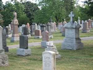 |
|
| St. John the Baptist, Norway Anglican Church | Kingston Road | 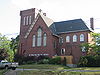 |
|
| Woodbine subway station Woodbine (TTC) Woodbine is a station on the Bloor–Danforth line of the subway system in Toronto, Canada. The address of the station is 2072 Danforth Avenue and it is physically located at the intersection of Woodbine Avenue and Strathmore Boulevard.... |
Danforth Ave | 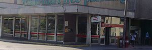 |
|
| Toronto Chinese Mennonite Church | Danforth | Formerly Rogers Memorial Presbyterian |
Northern section
| Landmark | Cross street | Notes | Image |
|---|---|---|---|
| Buttonville Buttonville, Ontario Buttonville is a suburban community part of Unionville within the Town of Markham in York Region, directly north of Toronto, Ontario, Canada. It is located in the western part of Unionville. The population is presently about 30,000. Rouge River is to the northeast and Buttonville Airport is... |
16th Ave | Former village | |
| Cathedral of the Transfiguration | Major Mackenzie | ||
| Victoria Square Victoria Square, Ontario Victoria Square is an unincorporated community in Markham, Ontario, Canada.The community was formed in the early nineteenth century. The first church was built in 1830s on the east side of 4th Line, where the cemetery is still located. The Wesleyan Methodists built a wood-frame church south of the... |
Elgin Mills Rd | Unincorporated Village | |
| Fletcher's Fields Fletcher's Fields Fletcher's Fields is a rugby stadium in Markham, Ontario, Canada. It currently serves as home to the Toronto Rebellion of the Rugby Canada Super League. The stadium, which seats 3,000 people, has hosted numerous Canada national rugby union team matches in the past was one of the venues for the... |
19th Ave | Rugby Statdium | |
| Gormley Gormley, Ontario Gormley is a hamlet in York Region, Ontario, Canada that overlaps parts of Richmond Hill, and Whitchurch–Stouffville, two municipalities within the Greater Toronto Area. It was divided into two parts due to the construction of Highway 404. A portion of Gormley situated within Richmond Hill's... |
Stouffville Rd | Village | 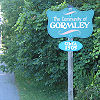 |
| Preston Lake Preston Lake, Ontario The Community of Preston Lake is located in the Town of Whitchurch–Stouffville in the Regional Municipality of York in Ontario... |
Bloomington Rd | Village and lake | |
| Vandorf Vandorf, Ontario Vandorf is a small hamlet situated in the Town of Whitchurch–Stouffville, Ontario, in Canada. It is the most westerly settlement within the Town of Whitchurch-Stouffville. With a population of approximately 722, Vandorf consists mainly of estate residential homes and farms.Vandorf was founded in... |
Vandorf Side Road | Village | |
| Wesley Corners Wesley Corners, Ontario Wesley Corners is a community situated in the Town of Whitchurch–Stouffville, Ontario, Canada.The hamlet is located at the intersection of Woodbine Avenue and York Regional Road 15/ Aurora Road. It was originally known as Hacking's Corners, after Rev. James Hacking who settled there in 1817... |
Aurora Road | Village | |
| Pleasantville Pleasantville, Ontario Pleasantville is a community located in the Town of Whitchurch–Stouffville, Ontario, Canada.It is a small hamlet consisting of mainly farms, residential homes and horse ranches... |
Vivian Road | Village |