
Windsor, New Jersey
Encyclopedia
Windsor is a small historic community and unincorporated area located within Robbinsville Township (known as Washington Township until 2007) in Mercer County
, New Jersey
, United States
. The area is served as United States Postal Service
ZIP Code
08561. There are approximately 50 homes in the area, and as of the United States Census, 2000
, the population for ZIP Code Tabulation Area
08561 was 314. While most of the locals have heard of neighboring West Windsor
and East Windsor
, few have heard of "just Windsor," which contributed to the naming of Windsor's community association website www.justwindsor.org.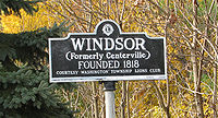
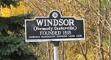
camps. Founded in 1818, it was named Centerville because it was the geographical center of the state. Until then, adjacent heavily wooded lands were called Magrilla (origins unknown). In 1814, after the completion of the Bordentown and South Amboy stagecoach turnpike, William McKnight, director of the turnpike company, built a tavern at the intersection of the turnpike and present-day Windsor-Perrineville Road. A major thruway between New York
and Philadelphia, the turnpike replaced Old York Road, which started out as a Native-American path prior to European settlement. In 1816 the local section of the stagecoach turnpike between New York and Philadelphia ran along Main Street. In late 1831, the Camden and Amboy Railroad was constructed through Centerville. The village became a stopover for rail travelers, and a thriving center for the bountiful farms and mills which serviced the growing population. It quickly became the largest village between Yardville (Sand Town) and Hightstown
, and was renamed "Windsor" in 1846 to avoid any confusion with a Centerville post office in Hunterdon County
.
Mercer County, New Jersey
As of the census of 2000, there were 350,761 people, 125,807 households, and 86,303 families residing in the county. The population density was 1,552 people per square mile . There were 133,280 housing units at an average density of 590 per square mile...
, New Jersey
New Jersey
New Jersey is a state in the Northeastern and Middle Atlantic regions of the United States. , its population was 8,791,894. It is bordered on the north and east by the state of New York, on the southeast and south by the Atlantic Ocean, on the west by Pennsylvania and on the southwest by Delaware...
, United States
United States
The United States of America is a federal constitutional republic comprising fifty states and a federal district...
. The area is served as United States Postal Service
United States Postal Service
The United States Postal Service is an independent agency of the United States government responsible for providing postal service in the United States...
ZIP Code
ZIP Code
ZIP codes are a system of postal codes used by the United States Postal Service since 1963. The term ZIP, an acronym for Zone Improvement Plan, is properly written in capital letters and was chosen to suggest that the mail travels more efficiently, and therefore more quickly, when senders use the...
08561. There are approximately 50 homes in the area, and as of the United States Census, 2000
United States Census, 2000
The Twenty-second United States Census, known as Census 2000 and conducted by the Census Bureau, determined the resident population of the United States on April 1, 2000, to be 281,421,906, an increase of 13.2% over the 248,709,873 persons enumerated during the 1990 Census...
, the population for ZIP Code Tabulation Area
ZIP Code Tabulation Area
ZIP Code Tabulation Areas are statistical entities developed by the United States Census Bureau for tabulating summary statistics from Census 2000. This new entity was developed to overcome the difficulties in precisely defining the land area covered by each ZIP code...
08561 was 314. While most of the locals have heard of neighboring West Windsor
West Windsor Township, New Jersey
-Demographics:As of Census 2010, West Windsor had a population of 27,165. The median age was 39.6. The racial and ethnic composition of the population was 54.9% White, 3.7% Black or African American, 0.1% Native American, 37.7% Asian, 1.0% some other race and 2.6% reporting two or more races...
and East Windsor
East Windsor Township, New Jersey
-Demographics:As of the census of 2000, there were 24,919 people, 9,448 households, and 6,556 families residing in the township. The population density was 1,592.8 people per square mile . There were 9,880 housing units at an average density of 631.5 per square mile...
, few have heard of "just Windsor," which contributed to the naming of Windsor's community association website www.justwindsor.org.
History
Earliest mention of the local area in the 17th century refers to it as a wilderness with several IndianNative Americans in the United States
Native Americans in the United States are the indigenous peoples in North America within the boundaries of the present-day continental United States, parts of Alaska, and the island state of Hawaii. They are composed of numerous, distinct tribes, states, and ethnic groups, many of which survive as...
camps. Founded in 1818, it was named Centerville because it was the geographical center of the state. Until then, adjacent heavily wooded lands were called Magrilla (origins unknown). In 1814, after the completion of the Bordentown and South Amboy stagecoach turnpike, William McKnight, director of the turnpike company, built a tavern at the intersection of the turnpike and present-day Windsor-Perrineville Road. A major thruway between New York
New York
New York is a state in the Northeastern region of the United States. It is the nation's third most populous state. New York is bordered by New Jersey and Pennsylvania to the south, and by Connecticut, Massachusetts and Vermont to the east...
and Philadelphia, the turnpike replaced Old York Road, which started out as a Native-American path prior to European settlement. In 1816 the local section of the stagecoach turnpike between New York and Philadelphia ran along Main Street. In late 1831, the Camden and Amboy Railroad was constructed through Centerville. The village became a stopover for rail travelers, and a thriving center for the bountiful farms and mills which serviced the growing population. It quickly became the largest village between Yardville (Sand Town) and Hightstown
Hightstown, New Jersey
Hightstown is a Borough in Mercer County, New Jersey, United States. As of the 2010 United States Census, the borough population was 5,494.Hightstown was incorporated as a borough by an Act of the New Jersey Legislature on March 5, 1853, within portions of East Windsor Township. The borough became...
, and was renamed "Windsor" in 1846 to avoid any confusion with a Centerville post office in Hunterdon County
Hunterdon County, New Jersey
Hunterdon County is a county located in the western section of the U.S. state of New Jersey. As of the 2010 United States Census, the population was 128,349. It is part of the New York Metropolitan Area. Its county seat is Flemington....
.
Notables residents
Notable current and former residents of Windsor include:- Elijah C. HutchinsonElijah C. HutchinsonElijah Cubberley Hutchinson was an American Republican Party politician who represented from 1915 to 1923....
(1855–1932), represented from 1915–1923.