
Winding Hills Park
Encyclopedia
Winding Hills Park is located off NY 17K
in the Comfort Hills two miles (3.2 km) west of the village of Montgomery
, New York
, United States
, straddling the Montgomery
-Crawford
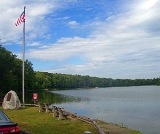
town line. It is a 502 acres (203.2 ha) area centered around 40 acres (16.2 ha) Diamond Lake that is primarily used for outdoor recreation.
Much of the park is wooded
, with some clear areas around the roads. The hills slope up to the east, and the terrain to the north and west remains gently rolling. Elevations range from 500 feet (151 m) above sea level at the west, where Pine Swamp drains toward the Wallkill River
via a short unnamed tributary
, to 780 feet (237.7 m) at the USGS
Kimball benchmark
.
The lake is available for paddleboat rental and angling
in season, and two smaller ponds on the property are also open to fishermen. There are 51 campsite
s available for overnight use, between May and October, with payment of an adequate reservation fee. A 10-mile (16 km) trail
system is open to hikers
and horseback riders
, as well as snowshoe
rs and snowmobile
rs in winter.
A 20-acre picnic area with 40 individual picnic sites is available for use. Each individual picnic site contains a table and charcoal grill. A picnic shelter for group use is also available. The rental fee for use of the shelter is $150.00, for both Orange County and Non-County groups.
New York State Route 17K
New York State Route 17K is an east–west state highway located within Orange County, New York, in the United States. It extends for from an intersection with County Route 76 east of Bloomingburg to a junction with U.S. Route 9W midway across the city of Newburgh...
in the Comfort Hills two miles (3.2 km) west of the village of Montgomery
Montgomery (village), New York
Montgomery is a village located in Orange County, New York, United States, 60 miles northwest of New York City, and 90 miles southwest of Albany. The population was 3,636 at the 2000 census...
, New York
New York
New York is a state in the Northeastern region of the United States. It is the nation's third most populous state. New York is bordered by New Jersey and Pennsylvania to the south, and by Connecticut, Massachusetts and Vermont to the east...
, United States
United States
The United States of America is a federal constitutional republic comprising fifty states and a federal district...
, straddling the Montgomery
Montgomery (town), New York
Montgomery is a town in Orange County, New York, United States. The population was 20,891 at the 2000 census. It was named in honor of Richard Montgomery, an American Revolutionary War general killed in 1775 at the Battle of Quebec....
-Crawford
Crawford, New York
Crawford is a town in Orange County, New York, USA. The population was 7,875 at the 2000 census. The name comes a settler who gave his name to a community in the town now called Pine Bush....
town line. It is a 502 acres (203.2 ha) area centered around 40 acres (16.2 ha) Diamond Lake that is primarily used for outdoor recreation.
Much of the park is wooded
Woodland
Ecologically, a woodland is a low-density forest forming open habitats with plenty of sunlight and limited shade. Woodlands may support an understory of shrubs and herbaceous plants including grasses. Woodland may form a transition to shrubland under drier conditions or during early stages of...
, with some clear areas around the roads. The hills slope up to the east, and the terrain to the north and west remains gently rolling. Elevations range from 500 feet (151 m) above sea level at the west, where Pine Swamp drains toward the Wallkill River
Wallkill River
The Wallkill River, a tributary of the Hudson, drains Lake Mohawk in Sparta, New Jersey, flowing from there generally northeasterly to Rondout Creek in New York, near Rosendale, with the combined flows reaching the Hudson at Kingston....
via a short unnamed tributary
Tributary
A tributary or affluent is a stream or river that flows into a main stem river or a lake. A tributary does not flow directly into a sea or ocean...
, to 780 feet (237.7 m) at the USGS
United States Geological Survey
The United States Geological Survey is a scientific agency of the United States government. The scientists of the USGS study the landscape of the United States, its natural resources, and the natural hazards that threaten it. The organization has four major science disciplines, concerning biology,...
Kimball benchmark
Benchmark (surveying)
The term bench mark, or benchmark, originates from the chiseled horizontal marks that surveyors made in stone structures, into which an angle-iron could be placed to form a "bench" for a leveling rod, thus ensuring that a leveling rod could be accurately repositioned in the same place in the future...
.
The lake is available for paddleboat rental and angling
Angling
Angling is a method of fishing by means of an "angle" . The hook is usually attached to a fishing line and the line is often attached to a fishing rod. Fishing rods are usually fitted with a fishing reel that functions as a mechanism for storing, retrieving and paying out the line. The hook itself...
in season, and two smaller ponds on the property are also open to fishermen. There are 51 campsite
Campsite
A campsite or camping pitch is a place used for overnight stay in the outdoors. In British English a campsite is an area, usually divided into a number of pitches, where people can camp overnight using tents or camper vans or caravans; this British English use of the word is synonymous with the...
s available for overnight use, between May and October, with payment of an adequate reservation fee. A 10-mile (16 km) trail
Trail
A trail is a path with a rough beaten or dirt/stone surface used for travel. Trails may be for use only by walkers and in some places are the main access route to remote settlements...
system is open to hikers
Hiking
Hiking is an outdoor activity which consists of walking in natural environments, often in mountainous or other scenic terrain. People often hike on hiking trails. It is such a popular activity that there are numerous hiking organizations worldwide. The health benefits of different types of hiking...
and horseback riders
Equestrianism
Equestrianism more often known as riding, horseback riding or horse riding refers to the skill of riding, driving, or vaulting with horses...
, as well as snowshoe
Snowshoe
A snowshoe is footwear for walking over the snow. Snowshoes work by distributing the weight of the person over a larger area so that the person's foot does not sink completely into the snow, a quality called "flotation"....
rs and snowmobile
Snowmobile
A snowmobile, also known in some places as a snowmachine, or sled,is a land vehicle for winter travel on snow. Designed to be operated on snow and ice, they require no road or trail. Design variations enable some machines to operate in deep snow or forests; most are used on open terrain, including...
rs in winter.
A 20-acre picnic area with 40 individual picnic sites is available for use. Each individual picnic site contains a table and charcoal grill. A picnic shelter for group use is also available. The rental fee for use of the shelter is $150.00, for both Orange County and Non-County groups.