

Wind wave model
Encyclopedia
Fluid dynamics
In physics, fluid dynamics is a sub-discipline of fluid mechanics that deals with fluid flow—the natural science of fluids in motion. It has several subdisciplines itself, including aerodynamics and hydrodynamics...
, wind wave modeling describes the effort to depict the sea state
Sea state
In oceanography, a sea state is the general condition of the free surface on a large body of water—with respect to wind waves and swell—at a certain location and moment. A sea state is characterized by statistics, including the wave height, period, and power spectrum. The sea state varies with...
and predict the evolution of the energy
Energy
In physics, energy is an indirectly observed quantity. It is often understood as the ability a physical system has to do work on other physical systems...
of wind waves using numerical techniques. These simulations consider atmospheric wind forcing, nonlinear wave interactions, and frictional dissipation, and they output statistic
Statistic
A statistic is a single measure of some attribute of a sample . It is calculated by applying a function to the values of the items comprising the sample which are known together as a set of data.More formally, statistical theory defines a statistic as a function of a sample where the function...
s describing wave height
Wave height
In fluid dynamics, the wave height of a surface wave is the difference between the elevations of a crest and a neighbouring trough. Wave height is a term used by mariners, as well as in coastal, ocean and naval engineering....
s, periods, and propagation directions for regional seas or global oceans. Such wave hindcast
Hindcast
A hindcast is a way of testing a mathematical model. Known or closely estimated inputs for past events are entered into the model to see how well the output matches the known results. Hindcasting is also known as backtesting....
s and wave forecast
Forecasting
Forecasting is the process of making statements about events whose actual outcomes have not yet been observed. A commonplace example might be estimation for some variable of interest at some specified future date. Prediction is a similar, but more general term...
s are extremely important for commercial interests on the high seas. For example, the shipping industry requires guidance for operational planning and tactical seakeeping
Seakeeping
Seakeeping ability is a measure of how well-suited a watercraft is to conditions when underway. A ship or boat which has good seakeeping ability is said to be very seaworthy and is able to operate effectively even in high sea states....
purposes.
For the specific case of predicting wind wave statistics on the ocean, the term ocean surface wave model is used.
Other applications, in particular coastal engineering, have led to the developments of wind wave models specifically designed for coastal applications.
Historical overview
Early forecasts of the sea stateSea state
In oceanography, a sea state is the general condition of the free surface on a large body of water—with respect to wind waves and swell—at a certain location and moment. A sea state is characterized by statistics, including the wave height, period, and power spectrum. The sea state varies with...
were created manually based upon empirical
Empirical
The word empirical denotes information gained by means of observation or experimentation. Empirical data are data produced by an experiment or observation....
relationships between the present state of the sea, the expected wind conditions, the fetch/duration, and the direction of the wave propagation. Alternatively, the swell
Swell (ocean)
A swell, in the context of an ocean, sea or lake, is a series surface gravity waves that is not generated by the local wind. Swell waves often have a long wavelength but this varies with the size of the water body, e.g. rarely more than 150 m in the Mediterranean, and from event to event, with...
part of the state has been forecasted as early as 1920 using remote observations.
During the 1950s and 1960s, much of the theoretical groundwork necessary for numerical descriptions of wave evolution was laid. For forecasting purposes, it was realized that the random nature of the sea state was best described by a spectral decomposition in which the energy of the waves was attributed to as many wave trains as necessary, each with a specific direction and period. This approach allowed to make combined forecasts of wind seas and swells. The first numerical model based on the spectral decomposition of the sea state was operated in 1956 by the French Weather Service, and focused on the North Atlantic. The 1970s saw the first operational, hemispheric wave model: the spectral wave ocean model (SWOM) at the Fleet Numerical Oceanography Center.
First generation wave models did not consider nonlinear wave interactions. Second generation models, available by the early 1980s, parameterized these interactions. They included the “coupled hybrid” and “coupled discrete” formulations. Third generation models explicitly represent all the physics relevant for the development of the sea state in two dimensions. The wave modeling project (WAM), an international effort, led to the refinement of modern wave modeling techniques during the decade 1984-1994.
Improvements included two-way coupling between wind and waves, assimilation of satellite wave data, and medium-range operational forecasting.
Wind wave models are used in the context of a forecasting or hindcasting system. Differences in model results arise, with decreasing order of importance, from differences in wind and sea ice forcing, differences in parameterizations of physical processes, the use of data assimilation
Data assimilation
Applications of data assimilation arise in many fields of geosciences, perhaps most importantly in weather forecasting and hydrology. Data assimilation proceeds by analysis cycles...
and associated methods, the numerical techniques used to solve the wave energy evolution equation.
Input
A wave model requires as initial conditions information describing the current state of the sea. An analysis of the sea or ocean can be created through data assimilation, where observations such as buoy or satellite altimeter measurements are combined with a background guess from a previous forecast or climatology to create the best estimate of the current conditions.Representation
The sea state is described as a spectrum; the sea surface can be decomposed into waves of varying frequenciesFrequency
Frequency is the number of occurrences of a repeating event per unit time. It is also referred to as temporal frequency.The period is the duration of one cycle in a repeating event, so the period is the reciprocal of the frequency...
using the principle of superposition. The waves are also separated by their direction of propagation. The model domain size can range from regional to the global ocean. Smaller domains can be nested within a global domain to provide higher resolution in a region of interest. The sea state evolves according to physical equations, which include wave propagation
Wave propagation
Wave propagation is any of the ways in which waves travel.With respect to the direction of the oscillation relative to the propagation direction, we can distinguish between longitudinal wave and transverse waves....
/ advection, and a source function which allows for wave energy to be augmented or diminished. The source function has at least three terms: wind forcing, nonlinear transfer, and dissipation by whitecapping. Wind data are typically provided from a separate atmospheric model from an operational weather forecasting center.
For intermediate water depths the effect of bottom friction should also be added. At ocean scales, the dissipation of swells - without breaking- is a very important term.
Output
The output of a wind wave model is a description of the wave spectra, with amplitudes associated with each frequency and propagation direction. Results are typically summarized by the significant wave heightSignificant wave height
In physical oceanography, the significant wave height is defined traditionally as the mean wave height of the highest third of the waves , but now usually defined as four times the standard deviation of the surface elevation...
, which is the average height of the one-third largest waves, and the period and propagation direction of the dominant wave.
Coupled models
Wind waves also act to modify atmospheric properties through frictional drag of near-surface winds and heat fluxes. Two-way coupled models allow the wave activity to feed back upon the atmosphere.WAVEWATCH
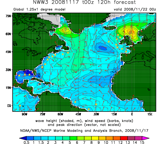
The operational wave forecasting systems at NOAA are based on the WAVEWATCH III model. This system has a global domain of approximately 100 km resolution, with nested regional domains for the northern hemisphere oceanic basins at approximately 25 km resolution. Physics includes wave field refraction, nonlinear resonantNonlinear resonance
In physics, nonlinear resonance is the occurrence of resonance in a nonlinear system. In nonlinear resonance the system behaviour – resonance frequencies and modes – depends on the amplitude of the oscillations, while for linear systems this is independent of amplitude.-Description:Generically two...
interactions, sub-grid representations of unresolved islands, and dynamically updated ice coverage. Wind data is provided from the GDAS data assimilation system for the GFS weather model. Up to 2008, the model was limited to regions outside the surf zone where the waves are not strongly impacted by shallow depths.
The model can handle the effects of currents on waves from its early design by Hendrik Tolman in the 1990s, and is now extended for nearshore applications.
Other models
The European Centre for Medium-Range Weather ForecastsEuropean Centre for Medium-Range Weather Forecasts
The European Centre for Medium-Range Weather Forecasts is an independent intergovernmental organisation supported by 19 European Member States and 15 Co-operating States...
(ECMWF) has incorporated the WAM wave model as part of its ensemble forecasting system. This model includes 30 frequency bins, 24 propagation directions, and an average spatial resolution of 40 km.
Wind wave forecasts are issued regionally by Environment Canada
Environment Canada
Environment Canada , legally incorporated as the Department of the Environment under the Department of the Environment Act Environment Canada (EC) (French: Environnement Canada), legally incorporated as the Department of the Environment under the Department of the Environment Act Environment...
.
Regional wave predictions are also produced by universities, such as Texas A&M University’s use of the SWAN model to forecast waves in the Gulf of Mexico.
Other wind wave models include the U.S. Navy
United States Navy
The United States Navy is the naval warfare service branch of the United States Armed Forces and one of the seven uniformed services of the United States. The U.S. Navy is the largest in the world; its battle fleet tonnage is greater than that of the next 13 largest navies combined. The U.S...
Standard Surf Model (NSSM).
The private sector is also active in producing wind wave simulations and surf forecasts
Surf forecasting
Surf forecasting is the process of using offshore swell data to predict onshore wave conditions. It is used by millions of people across the world, including professionals who put their forecasts online, meteorologists who work for news crews, and surfers all over the world...
. For example, Oceanweather Inc. provides global operational forecasts and hindcasts of the sea state.
Validation
Comparison of the wave model forecasts with observations is essential for characterizing model deficiencies and identifying areas for improvement. In-situ observations are obtained from buoys, ships and oil platforms. Altimetry data from satellites, such as GEOSATGeosat
The GEOSAT was a U.S. Navy Earth observation satellite, launched on March 12, 1985 into an 800 km, 108° inclination orbit, with an orbital period of 23.07 days and a 330 pass orbit. The satellite carried a radar altimeter capable of measuring the distance from the satellite to sea surface...
and TOPEX, can also be used to infer the characteristics of wind waves.
Hindcasts of wave models during extreme conditions also serves as a useful test bed for the models.
Reanalyses
A retrospective analysis, or reanalysis, combines all available observations with a physical model to describe the state of a system over a time period of decades. Wind waves are a part of both the NCEP Reanalysis and the ERA-40ERA-40
ERA-40 is a ECMWF re-analysis of the global atmosphere and surface conditions for 45-years, over the period from September 1957 through August 2002 by ECMWF. Many sources of the meteorological observations were used, including radiosondes, balloons, aircraft, buoyes, satellites, scatterometers....
from the ECMWF. Such resources permit the creation of monthly wave climatologies, and can track the variation of wave activity on interannual and multi-decadal time scales. During the northern hemisphere winter, the most intense wave activity is located in the central North Pacific south of the Aleutians, and in the central North Atlantic south of Iceland. During the southern hemisphere winter, intense wave activity circumscribes the pole at around 50°S, with 5 m significant wave heights typical in the southern Indian Ocean.